Monthly News Summary – June 2011
- Satellites Detail Devastating Tornado Outbreaks
- Grímsvötn Volcanic Eruption
- MODIS Images Show Flooding at the Confluence of the Mississippi and Ohio Rivers
- GOES-R Aviation/Nowcasting Applications Seminar Held at Environment Canada
- Webinar for Storm Spotters: Climate Change, Mitigation & Mobile Apps Presented
- National Science Olympiads Opens Pipeline to Future Scientists
- Science On a Sphere Network Conference
- Space News International Examines Coming GOES-R Advances
- Shturmakov Receives the Antarctica Service Medal
- “Satellites See Wisconsin” Exhibit Draws Praise
Satellites Detail Devastating Tornado Outbreaks
The Cooperative Institute for Meteorological Satellite Studies (CIMSS) Satellite Blog displays a variety of Geostationary Operational Environmental Satellite (GOES), Polar Operational Environmental Satellite (POES), and Moderate Resolution Imaging Spectroradiometer (MODIS) images of the significant tornado outbreaks that occurred on 22 May 2011 (which produced the deadly Joplin, Missouri EF-5 tornado and 24 May 2011 (which produced three EF-4 tornadoes across central Oklahoma).
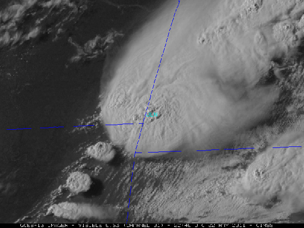
GOES-13 visible image of the tornadic supercell near the time that a large tornado was approaching Joplin, Missouri (JLN). The shadows from a number of overshooting tops can be seen on the anvil of the thunderstorm.
MODIS images showing tornado damage paths
Moderate Resolution Imaging Spectroradiometer (MODIS) visible and true color images, posted on the CIMSS Satellite Blog, showed several tornado damage paths across northern Alabama from the 27 April 2011 tornado outbreak across the southeastern United States.
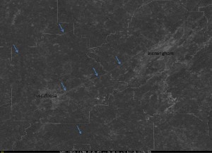
250 meter resolution MODIS 0.65 micrometer visible image showing 3 large tornado damage paths in the vicinity of Tuscaloosa and Birmingham in northern Alabama.
The Grímsvötn volcano in Iceland began erupting violently on 21 May 2011 and continued to erupt until 25 May 2011, disrupting air traffic over the North Atlantic and Europe.
The Center for Satellite Applications and Research (STAR) and the Cooperative Institute for Meteorological Satellite Studies (CIMSS) provided near real-time satellite retrievals of ash cloud height, mass loading, and particle size to the volcanic ash operational and research community, including the London Volcanic Ash Advisory Center (VAAC), through the CIMSS Web site.
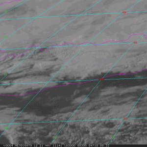
Meteosat-9 visible channel images showed the volcanic eruption cloud emanating from the Grímsvötn volcano in Iceland on 21 May 2011 (images courtesy of Dave Santek, SSEC). According to the Icelandic Met Office, at 21:00 UTC the eruption plume had risen to an altitude of over 65,000 ft (~20 km).
NOAA/NESDIS/STAR contributed satellite-derived information on the height and horizontal location of volcanic ash to these reports.
STAR and CIMSS scientists developed the volcanic ash products in preparation for the next generation Geostationary Environmental Operational Satellite (GOES-R). The Spinning Enhanced Visible/Infrared Imager (SEVIRI) was used as a proxy for GOES-R data. In addition, several new satellite images and animations of the eruption have been added to the CIMSS Satellite Blog and the STAR web site contains additional information about the eruption and the STAR/CIMSS volcanic ash products.
In response to the eruption, the NOAA Volcanic Ash Working Group (VAWG) prepared twice daily significant event reports to NOAA senior leadership. These reports were used to help brief White House officials on the status of the ash cloud over Europe and the North Atlantic.
The airborne volcanic ash is a major threat to aviation. Satellite products developed by NOAA/NESDIS/STAR were used to quantitatively track Grímsvötn volcanic ash in near real-time as it spread over the North Atlantic and Europe, impacting air traffic, while President Obama was visiting Europe. London VAAC was responsible for issuing ash cloud advisories for the Grímsvötn cloud.
MODIS Images Show Flooding at the Confluence of the Mississippi and Ohio Rivers
Moderate Resolution Imaging Spectroradiometer (MODIS) visible, near-IR, and true color images posted on the CIMSS Satellite Blog showed the areal coverage of flooding across the region surrounding the confluence of the Mississippi River and the Ohio River on 4 May 2011.
In addition, a comparison of MODIS true color images from 4 May 2010 and 4 May 2011 reveal dramatic changes in the Mississippi River north of Memphis, Tennessee.
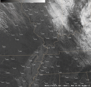
A comparison of AWIPS images of the 1-km resolution MODIS 0.65 µm visible channel (first shown with a map overlay and location of METAR sites) and the corresponding 1-km resolution MODIS 2.1 µm near-IR “snow/ice channel” shows the areal coverage of flood waters across the region of the confluence of the Mississippi River and the Ohio River on 4 May 2011. Water appears very dark on the MODIS near-IR “snow/ice” image.
GOES-R Aviation/Nowcasting Applications Seminar Held at Environment Canada
Wayne Feltz (Cooperative Institute for Meteorological Satellite Studies) gave a seminar titled “GOES-R Overview of Aviation and Nowcasting Applications: Current Status and a Look into Future” on 28-29 April 2011 at Environment Canada’s headquarters in Toronto (hosted by Ismail Gultepe) and at the Canadian Meteorological Centre in Montreal (hosted by Louis Garand).
The presentation covered new research developments regarding the use of infrared radiances to provide information on detection of turbulence, convective initiation, convective overshooting, volcanic ash, and low cloud/fog. The seminars were very well attended and provided additional justification for Canada to continue pursuing the new Polar Communication and Weather (PCW) satellite mission, a highly elliptical orbit that would provide “pseudo-geostationary” coverage of the Arctic.
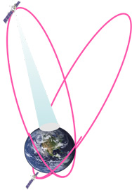
The highly elliptical orbit that will be used by the PCW mission.
Webinar for Storm Spotters: Climate Change, Mitigation & Mobile Apps Presented
National Weather Service (NWS) Storm Spotters attended a web seminar on 10 May 2011 presented by Steve Ackerman and Margaret Mooney from the Cooperative Institute for Meteorological Satellite Studies (CIMSS).
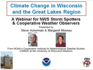
The topics were climate change, climate mitigation, and emerging applications to monitor weather and climate using mobile devices. CIMSS hopes to leverage the wealth of human capital cultivated by the NWS with storm spotters’ history of community service and passion for weather to cultivate a similar mitigation and stewardship response to climate change.
CIMSS would like to thank Rusty Kapela, Warning Coordination Meteorologist from Milwaukee/Sullivan, for helping to recruit spotters and Erin Robinson from the Federation of Earth Science Information Partners (ESIP) for hosting and recording the webinar which is available for viewing.
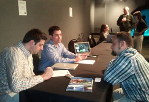
National Science Olympiad Opens Pipeline to Future Scientists
Patrick Rowley and Margaret Mooney from the Cooperative Institute for Meteorological Satellite Studies (CIMSS) staffed an exploration station at the Wisconsin Institute for Discovery on 20 May 2011 for young scholars attending the National Science Olympiad (NSO) in Madison, Wisconsin. The station featured the popular weather and climate applets developed at CIMSS which are available on-line. The middle and high school scholars attending were state champions destined for science-related careers.
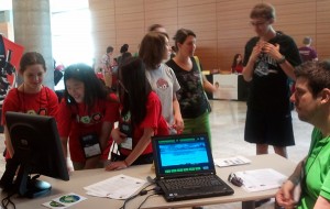

Patrick Rowley, CIMSS, showcasing the CIMSS applets at the Wisconsin Institutes for Discovery
Other participants at AOSS are sharing their expertise with National Science Olympiad (NOS) scholars this week, were:
- Jesse Roberts, AOS, presented climate science & ocean research.
- Hsuan-Yun Pi, SSEC, co-presented with Dolly Ledin on regional climate change.
- Dan Hartung, CIMSS/SSEC, presented aviation forecasting & SNAAP research at the CAVE (CIMSS Analysis and Visualization Environment).
- Ed Hopkins, of the State Climatology Office, gave a tour to AMS Educators and their NOS students.
Tours conducted at AOSS also visited the 3D globe, AMRC and, of course, the roof.
These middle and high school students at NSO are all state champions and likely to be society’s scientists of tomorrow.
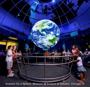
Science On a Sphere Network Conference
The 2011 Science On a Sphere (SOS) Network conference was held 3-5 May 2011 at the Museum of Science and Industry in Chicago, IL. With almost 70 SOS installations around the world (and even more institutions with other spherical display devices, like our 3D Globe), the network is growing rapidly. At the last SOS conference in November 2009, there were only 35 SOS installations. Margaret Mooney and Patrick Rowley represented CIMSS at the conference and along with Dan Pisut (NOAA Environmental Visualization Lab), helped solicit feedback about our nascent EarthNow project, a NOAA ELG-funded project aimed at assisting museum docents with interpretation of real-time weather and climate data on spherical displays.
Patrick Rowley also gave a joint presentation with Peter Leighton (Nauticus Maritime Science Museum, Norfolk, VA) about the use of real-time data on Science On Spheres. Peter provided information about the Earth Watch program at Nauticus, which Patrick helped to create during his time there. Patrick followed that up with a preview of the EarthNow blog/website and how the project will help enhance docents’ understanding of real-time data, leading to higher quality SOS presentations.
Rowley was joined by Margaret Mooney from CIMSS and Dan Pisut from NOAA in a break-out session collecting user feedback to advise the project moving forward.
If you have global data you think will help convey weather-climate relationship stories, please contact Patrick. The project is in its early stages and any feedback is welcome!
submitted by Patrick Rowley
Space News International Examines Coming GOES-R Advances
Tim Schmit, meteorologist at NOAA’s Center for Satellite Applications and Research at the UW-Madison, was among those interviewed by Space News International for an article entitled “Weather Satellites Saw Tornado Swam Coming 5 Days Out.” The story highlighted coming advances in the next generation Geostationary Operational Environmental Satellite (GOES)-R and potential benefits, especially those associated with severe weather.
Shturmakov Receives the Antarctica Service Medal
Alex Shturmakov, Engineering and Research Director of Ice Coring and Drilling Services, has been awarded the Antarctica Service Medal. The medal is an award of the United States military, issued in the name of the Department of Defense, and is authorized for wear on active duty uniforms. The medal may also be awarded to U.S. civilians, but after the initial award, the civilian may only wear the miniature or the lapel pin depending on the occasion.
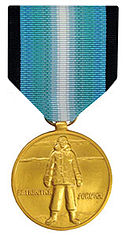
To qualify for the Antarctica Service Medal, personnel must serve between fifteen to thirty days stationed on the Antarctic continent, defined as south of 60 degrees latitude.
“Satellites See Wisconsin” Exhibit Draws Praise

The “Comments” box at the “Satellites See Wisconsin” exhibit at the Dane County Regional Airport keeps filling up with positive reviews. Here are a few of them.