Monthly News Summary – October 2010
- McIDAS-V Graduates from Beta to 1.0
- Into the Blue: Drilling the Blue Ice
- CIMSS Scientists in Tri-Agency Hurricane Research Project
- GOES-15 NOAA Science Test Concludes
- GOES, MODIS, and POES Capture Wildfire
- AOSS Photo Contest Focuses on Wisconsin Weather
- CIMSS Animation of Hurricane Igor on ABC World News
- AMRC and Lazzara Featured in Weatherwise Article
- Bachmeier Named NESDIS Team Member of the Month
- WisconsinEye Features Weather Satellites
- SSEC Provides Funding for Innovative Habitat
- Jim Kossin Interviewed on WNYC
- Mike Pavolonis Gives Public Lecture on Volcanic Ash
- Paper on Cloud Composition Remote Sensing Published
McIDAS-V Graduates from Beta to 1.0
After more than 3 years in development, the Man-computer Interactive Data Access System (McIDAS) has left the “beta” designation and is now an operationally supported software toolkit. This fifth generation of McIDAS is a Java-based, open-source system designed to support new environmental satellite observations and their multispectral and hyperspectral researchers and algorithm developers.
McIDAS-V provides powerful new data manipulation and visualization tools to work in this data rich environment. Unlike most other 2-D weather display tools, the multi-dimensional display capability brings weather data into the three-dimensional world with powerful new display capabilities. This new data analysis and visualization system will support both researchers and operational users of the advanced measurement systems on GOES-R, JPSS, and Metop.
![]()
McIDAS had its origins in the early 1970’s. The data analysis and visualization capabilities of this system were state-of-the-art for many years and continue to provide powerful tools even 35 years later. The software is used by many atmospheric scientists in research, operations and industry.
McIDAS-V is a software ensemble containing many features. It builds upon several years of VisAD and IDV development to enhance functionality. McIDAS-V will integrate the multi- and hyperspectral satellite data capabilities from HYDRA and allow a two-way dialog with a McIDAS-X session to make those data and products available. In addition to these powerful attributes, McIDAS-V offers improved data and server management and a friendly, user-configurable interface. Finally, since the software is freely available and open source, we will add our own and our collaborators’ improvements to continue to evolve the capabilities of the software.
Learn more about McIDAS-V and download the software, user manuals, and training materials, at our new web site.
We also encourage you to take advantage of the McIDAS Users Group.
Into the Blue: Drilling the Blue Ice
On 17 September 2010 the Ice Drill Design and Operations (IDDO) group at the UW-Madison Space Science and Engineering Center presented their Blue Ice Drill for review to Jeff Severinghaus, Principal Investigator of the National Science Foundation’s Office of Polar Programs.
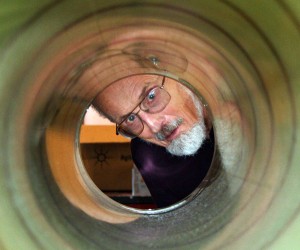
Professor Emeritus Charles Bentley, Principal Investigator of Ice Coring and Drilling Services, examines the barrel of the Blue Ice Drill.
The IDDO group designed, built, and tested the new drill. Developed specifically to take samples from blue ice – a dense, extremely hard ice formed deep under the Antarctic ice sheet by the incredible pressure of hundreds, even thousands, of meters of ice above it. If a flowing glacier meets an immovable geological structure, such as a mountain, the blue ice at the bottom of the glacier can be forced to the surface. As the years pass, the oldest ice in the glacier is exposed to the light, and to researchers’ drills.
Studying the bubbles of ancient atmosphere trapped in the ice can reveal much about the Earth’s climate in millennia past.
The drill was designed with simplicity in mind. Generally, three scientists and two technicians will be present on site for the drilling, but as few as two people can operate the device. The drill cuts a very large core sample: 24 cm thick and a meter deep. One of the challenges facing the IDDO team was snapping the core of super-hardened ice off of its parent glacier at depth in a narrow, confined bore hole. A second piece of equipment, the Core Recovery Drill, is sent down into the hole where a piston on the side of the recovery tool drives the sample horizontally.
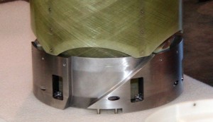
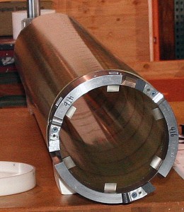
Two views of the Blue Ice Drill head.
The drill can bore 12 meters down into the ice and produce 7 sample cores per day. The disassembled drill is small and light enough (at most 500kg/1100lbs) to fit into a Bell 212 helicopter.
The Blue Ice Drill passed its review with flying colors. The drill will be deployed this season in Antarctica.
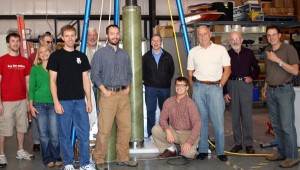
The IDDO group presented the Blue Ice drill for Jeff Severinghaus’ (NSF Principal Investigator – kneeling) approval. From left to right: Josh Goetz, Fred Best, Kristina Dahnert, Jay Johnson, Tony Wendricks, Tanner Kuhl, Tom Demke, Alex Shturmakov, Charles Bentley, Chris Gibson. Not pictured: Michael Gerasimoff and Don Lebar.
CIMSS Scientists in Tri-Agency Hurricane Research Project
A team from the Cooperative Institute for Meteorological Satellite Studies (CIMSS) returned this week from St. Croix, U.S. Virgin Islands, the operations center of the NSF-sponsored PRE-Depression Investigation of Cloud systems in the Tropics (PREDICT) experiment. PREDICT, a major collaborative tri-agency (NOAA/NASA/NSF) hurricane field project, is designed to study the genesis and rapid intensification of tropical cyclones in the Atlantic.
Prediction and understanding of tropical cyclogenesis remains one of the most challenging aspects of atmospheric science. A multitude of tropical disturbances emerge from the West African coast near the Cape Verde islands every year, but only a few of these develop into tropical depressions, storms, or hurricanes.
Scientists from CIMSS are supplying satellite expertise and support for the project, including hurricane diagnostic algorithms based on polar and geostationary satellites, and is participating directly in real-time mission planning/coordination, forecasting, nowcasting, and data analysis.
The PREDICT field experiment deployed the NSF/NCAR Gulfstream V aircraft in the Atlantic basin in the heart of hurricane season, 15 August – 30 September 2010, to explore multi-scale interactions in tropical wave-like disturbances that promote or hinder the development of a tropical depression vortex.
The U.S. Virgin Islands was chosen because it offers the best range for the Gulfstream V to cover the area of interest to the scientists and because of its airport and support facilities.
PREDICT is one project in a tri-agency collaborative study of the formation of tropical hurricanes. The National Center for Atmospheric Research (NCAR), National Aeronautics and Space Administration (NASA) and National Oceanic and Atmospheric Administration (NOAA) will collaborate and coordinate multi-aircraft deployments over the tropical Atlantic Ocean. These three projects are being deployed simultaneously, each having their own specific hypotheses and agenda, however each are complimenting the others.
NESDIS is providing support through GOES-East, and special rapid-scan datasets being provided as part of the GOES-15 science checkout. The multi-platform observations from this summer’s hurricane project will be used in research analysis for years to come. The project ended on 1 October 2010.
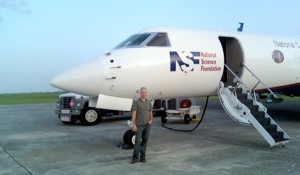
CIMSS scientist Derrick Herndon in front of the NSF/NCAR Gulfstream-V jet used in PREDICT.
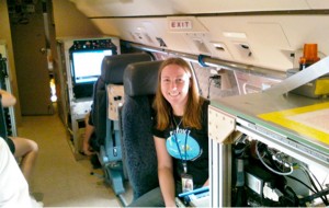
CIMSS graduate student Sarah Monette aboard the GV during a mission.
Project overview and video.
Slideshow of operations.
PREDICT Support page.
John Sears, student blog.
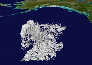
GOES-15 NOAA Science Test Concludes
The last day of the NOAA Geostationary Operational Environmental Satellite (GOES)-15 Science Test consisted of 1-minute imagery over the Midwest. Animations of the full day (12:45 – 23:45 UTC on 21 September) of GOES-15 1-minute interval SRSO imagery have been posted on the CIMSS blog.
The GOES-15 NOAA Science test began on 11 August 2010 and concluded on 22 September 2010 and was lead by Tim Schmit (SSEC) and Donald Hillger (NOAA).
More information and the rapid scan imagery is available online, as are other results.
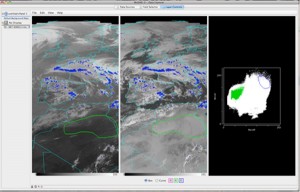
GOES, MODIS, and POES Capture Wildfire
Geostationary Operational Environmental Satellite (GOES), MODerate resolution Imaging Spectroradiometer (MODIS), and Polar Operational Environmental Satellite (POES) captured images of the wildfire at Fourmile Canyon near Boulder, Colorado on 6 September 2010 and the fire resulting from a deadly natural gas explosion at San Bruno, California on 9 September 2010.
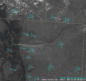
AWIPS images of the MODIS visible, shortwave IR, and IR window channels, showing the smoke plume and thermal “hot spot” from the large Fourmile Canyon fire west of Boulder, Colorado, on 6 September 2010.
AOSS Photo Contest Focuses on the Art and Science of Wisconsin Weather
Eleven photographers (all scientists, faculty, staff and/or students from the Atmospheric Oceanic and Space Sciences Building (of which SSEC is a part) submitted nearly two dozen images, illustrating that the scientific eye encompasses art as well.
The winning entries are:
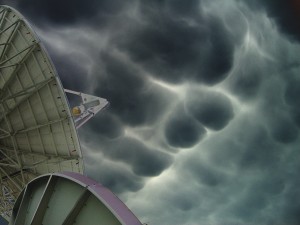
1st Place: Hank Revercomb for Mammatus Clouds
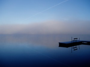
2nd Place: Tom Achtor for Autumn Fog
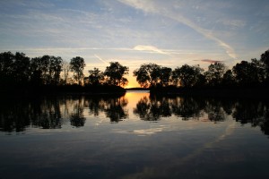
3rd Place: Bill Bellon for Contrail Cloud at Sunset
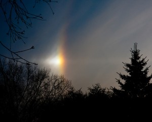
Honorable Mention: Grant Petty for Vivid Perihelion (Sundog
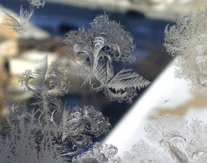
Honorable Mention: Hank Revercomb for Frost Sculptures
To view the rest of the entries, either visit the exhibit located on the third floor of the AOSS Building, west corridor, outside the Schwerdtfeger Library, or check out the online slideshow.
CIMSS Animation of Hurricane Igor on ABC World News
ABC World News with Diane Sawyer and the Weather Channel featured Cooperative Institute for Meteorological Satellite Studies (CIMSS) Geostationary Operational Environmental Satellite (GOES)-15 animated imagery of Hurricane Igor on their 13 September 2010 broadcasts. The QuickTime movie used in the broadcasts was compiled by Scott Bachmeier (SSEC).
Hurricane Igor was also featured during the week of 11-17 September 2010 in a number of posts to the CIMSS Satellite Blog – in particular, GOES-15 1-minute interval Super Rapid Scan Operations (SRSO) visible images of the hurricane at Category 4 intensity.
AMRC and Lazzara Featured in Weatherwise Article
The September/October issue of Weatherwise magazine headlines an article by Ann Posegate entitled “Observing Weather at the Bottom of the World: The South Pole.” The article features the work of the Antarctic Meteorological Research Center. Matthew Lazzara, who gave an in-depth interview for the article, describes the Antarctic Automatic Weather Stations system.
Weatherwise front page and article.
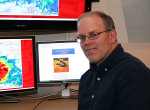
Bachmeier Named NESDIS Team Member of the Month
Scott Bachmeier of the Cooperative Institute for Meteorological Satellite Studies (CIMSS) was selected NESDIS Team Member of the Month, effective October 2010. Scott was nominated for his efforts to improve public awareness of NOAA satellite applications, both for the general public and for NOAA
WisconsinEye Features CIMSS and Weather Satellites
Steve Ackerman, Director of the Cooperative Institute for Meteorological Satellite Studies (CIMSS), and Jeff Key, Chief of the NESDIS/STAR Advanced Satellite Products Branch, were interviewed for a WisconsinEye video segment on weather satellites and the recent CIMSS re-competition.
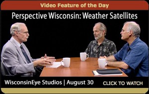
The 35-minute piece, titled “Wisconsin Perspective: Weather Satellites,” is available online.
SSEC Provides Funding for Innovative Habitat
UW undergrads from several disciplines are participating in a joint NASA/National Space Grant Foundation effort to design, build, and test an inflatable, hard-shell habitat that astronauts can transport to their destination (in orbit, the Moon, Mars) and use to expand their living quarters.
“This project will allow us to improve upon an already excellent educational design course model, specifically in the area of systems engineering, while attracting a broad range of organizations,” says Fred Best, SSEC technical director. “I think this group of students is going to be very successful and I hope to see more collaboration like this in the future.”
SSEC is supplying outreach funds for the project, enabling students to connect with various experts and a private systems engineer.
The UW College of Engineering has posted a complete article on the project.
Jim Kossin Interviewed on WNYC
Leonard Lopate, on New York’s National Public Radio station WNYC, interviewed NOAA scientist Jim Kossin regarding new developments in hurricane science in the past five years since since Katrina.
Mike Pavolonis Gives Public Lecture on Volcanic Ash
Mike Pavolonis (NOAA/NESDIS) gave an invited public lecture on 15 September 2010 entitled “The role of satellites in preventing aircraft encounters with volcanic ash.”
The lecture was part of the University of Wisconsin Alumni Association “Wednesday Nite @ the Lab” lecture series. The lecture, which was free and open to the public, was also broadcast live on the Internet and will be shown on Wisconsin Public Television in the coming months
Paper on Cloud Composition Remote Sensing Published
A paper by Michael Pavolonis (NOAA/NESDIS/STAR) entitled “Advances in Extracting Cloud Composition Information from Spaceborne Infrared Radiances: A Robust Alternative to Brightness Temperatures Part I: Theory” was published in the September 2010 issue of the Journal of Applied Meteorology and Climatology. The paper describes the theory behind a new approach for determining cloud phase and detecting volcanic ash and dust clouds.