Lake Michigan Ozone Study 2017: Collaborative field campaign will pursue sources and transport of ozone
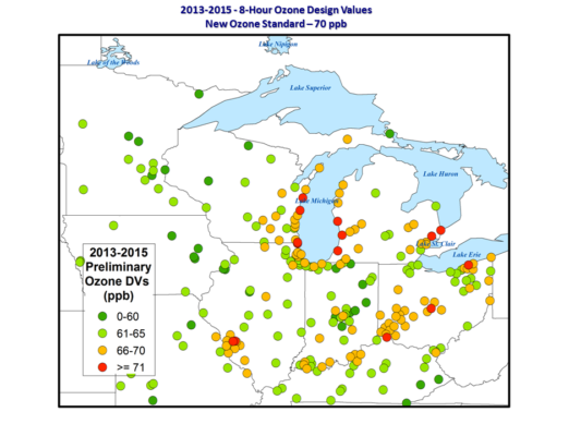
Preliminary 2013-2015 Design Values (DV) for ozone in the Midwestern US showing high ozone mixing ratios along the coast of Lake Michigan. The ozone Design Value (DF) is the 3 year average of fourth highest 8-hour mean ozone mixing ratio in parts per billion by volume (ppb) observed at surface monitor stations. Design Values above 70ppb violate the new ozone standard established by the U.S. Environmental Protection Agency (EPA). Figure credit: Rob Kaleel (LADCO)
For years communities around Lake Michigan have had issues with an overabundance of surface-level ozone, leading to exceedances (or violations) of federal air quality standards as set by the U.S. Environmental Protection Agency (EPA). Excessive ozone near the surface can lead to significant respiratory health problems in people, as well as damage vegetation.
Learning more about the origins of this ozone is key to addressing the problem. In this case, an equally important component is understanding the role of atmospheric dynamics in moving the ozone from its source in urban areas to the areas with the highest concentrations, which tend to be along the Lake Michigan shoreline.
Brad Pierce, a NOAA Advanced Satellite Products Branch scientist stationed at the Cooperative Institute for Meteorological Satellite Studies (CIMSS) at the University of Wisconsin-Madison, is part of a team planning to collect and analyze observations of ozone and its precursors over Lake Michigan during a field campaign next summer, from mid-May to mid-June.
The Lake Michigan Ozone Study 2017 (LMOS 2017) was commissioned to fill in important knowledge gaps about ozone formation along the lakeshore raised by Angela Dickens of the Wisconsin Department of Natural Resources (DNR) and Rob Kaleel of the Lake Michigan Air Directors Consortium (LADCO). LADCO is a non-profit organization established by states surrounding Lake Michigan (Illinois, Indiana, Michigan, Wisconsin, Minnesota, and Ohio) to monitor and assess air quality and to support states in their discussions of air quality issues and in their development of State Implementation Plans (SIPs) to mitigate air quality problems.
Dickens and Kaleel brought these scientific questions to the NASA Air Quality Applied Sciences Team (AQAST), of which Pierce is a member, and the result was a planned field experiment to study Lake Michigan ozone.
“There are these sites along the lake… that are in violation, and they’re not really areas that have a whole lot of industry,” says Pierce. “The sense is that a lot of this has to do with lake breeze circulations. We want to go out and measure the lake breeze circulation and the transport of ozone precursors – the emissions that end up producing ozone – in the springtime when this lake breeze is most dominant.”
Pierce notes that spring is ideal for such a study as the land is warming up and the water is still cold, an environment that is favorable for lake breeze circulation. In addition, ozone measurements are more likely to exceed EPA standards at this time of year.
The mission involves coordinating multiple science and instrument teams. NASA’s Airborne Science Program is onboard to supply the Geostationary Trace gas and Aerosol Sensor Optimization (GeoTASO), an airborne simulator that mimics the future Tropospheric Emissions: Monitoring of Pollution (TEMPO) instrument; TEMPO will provide the first air quality measurements from a geostationary satellite, says Pierce. Campaigns using airborne simulators provide scientists an opportunity to prepare for working with the satellite-based version once it is launched.
“[GeoTASO is] very useful for trying to map out NO2 (nitrogen oxide) emissions. NO2 is one of the main precursors to ozone formation. We’ll be mapping out the column NO2 amounts and trying to look at how it’s transported up the shore of Lake Michigan,” says Pierce.
Two mobile trailers with ground-based remote sensing instruments will also be deployed. The National Severe Storms Laboratory and the University of Oklahoma will send their Collaborative Lower Atmospheric Mobile Profiling System (CLAMPS). CLAMPS will carry an Atmospheric Emitted Radiance Interferometer (AERI), an instrument developed at UW-Madison’s Space Science and Engineering Center (SSEC), to provide temperature and water vapor profiles, plus a Halo wind lidar to measure winds.
The LMOS2017 team is considering Zion, Illinois as a possible site for CLAMPS. Located on the shores of Lake Michigan, Zion is north of Chicago, near the Wisconsin-Illinois border – a location that would allow the team to obtain measurements of ozone and its precursors close to their potential source.
Additional ground-based instruments placed at Zion will provide in situ measurements necessary to study the Chicago plume in greater detail – beyond just the column distribution of NO2 – to focus on all the nitrogen species and volatile organic compounds (VOCs).
With this additional layer of vital information, says Pierce, “We can really understand the ozone photochemistry of that plume.”
SSEC will also contribute its mobile trailer, the SSEC Portable Atmospheric Research Center (SPARC), to the campaign. The SPARC will also house an AERI and Halo wind lidar, plus a High Spectral Resolution Lidar (HSRL) to measure aerosol extinction and the boundary layer depth.
The plan is for the SPARC to be based in Sheboygan, Wisconsin. Sheboygan has had some of the largest ozone exceedances and would also be ideal for studying the effects of lake breeze circulation. In addition, the nearby Spaceport Sheboygan, a non-profit science education facility, will provide ample opportunities for K-12 students to learn firsthand about the effects of ozone in the atmosphere where they live.
The team may take measurements around Detroit, Michigan. In part, that depends on conditions and whether they are getting good data elsewhere. It also depends on where the NASA aircraft will be based, as that sets some limits on how far they can fly and take observations without refueling. If they choose to base the aircraft in Gary, Indiana, then Detroit is an option; if they choose Madison, Wisconsin, then Detroit is less likely, unless an additional airport could be used for refueling.
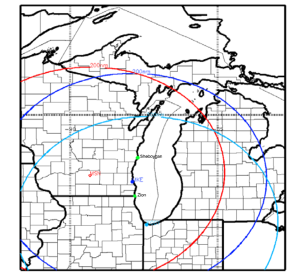
Map detailing possible locations for the aircraft base during LMOS2017, with rings indicating the aircraft range. Also shown are the mobile trailer sites.
Choosing Madison as the campaign base has its perks, though, as the aircraft would be nearby at Truax Field (which has been used as a base for numerous SSEC field campaigns). Plus, participants would be able to use SSEC for meetings. And yes, it would mean less travel for Pierce.
The data and analyses from the field campaign will be used later on as states develop their SIPs. Following the ozone along the lake breeze circulation back to its source impacts which state (or, possibly, states) will need to address the problem. For example, if an ozone source in one state leads to excessive ozone measurements in another state, both states will need to work together to create a mitigation plan.
A second component of this study is for scientists to determine how well their air quality models perform: Do they accurately capture and predict the level of emissions and their location? Pierce recalled their experience in studying a July 2011 ozone event in the area and the model difficulties that persist, even among those models that seemingly should provide better detail. Despite some success in capturing the transport of the ozone plume from this event, a higher-resolution (4 kilometer) model underperformed a lower-resolution (12 kilometer) model in terms of predicting the amount of ozone.
“There’s a lot we don’t understand about how big the emissions are in Chicago, though we have estimates of that. [Also] how much of all the emissions that go out, how much of it actually becomes NO2 that causes ozone production,” says Pierce. “We’ll see how well we’re able to resolve this transport within the lake breeze circulation.”
Improving the models is important because states use them in their implementation plans to demonstrate that emission reductions curb ozone production.
For now Pierce and the rest of the team are focused on all the necessary logistics to pull off a successful campaign, from getting the staff and instruments in the right places to securing additional funding.
All in all, says Pierce, “It’ll be a busy year trying to get that all put together.”
by Leanne Avila