Hurricane Matthew, network reliability, and public safety
Twenty years ago when a hurricane approached the coastal United States—or anywhere else in the world for that matter—peak demands for data and analyses from the Tropical Cyclones Research Team at the UW-Madison Cooperative Institute for Meteorological Satellite Studies (CIMSS) could bring the research center’s web servers to a grinding halt. And, says lead scientist Chris Velden, these events would sometimes interfere with servers elsewhere on campus, interrupting the flow of vital information to researchers, forecasters with government agencies around the world, and the public in affected areas.
But two decades hence, Hurricane Matthew tells a different story: one that outlines the importance of a robust computing infrastructure. This time around, critical access to the tropical cyclone group’s real-time imagery, analysis products, and intensity estimates, was uninterrupted, says Velden, thanks to the support provided by the team of IT professionals at SSEC and ongoing improvements to the campus network bandwidth that make it possible to quickly move large amounts of data. Collaboration across campus has resulted in a system designed to protect against overloads and failures.
SSEC systems administrator and network engineer John Lalande reported that on Wednesday, 6 October and Thursday, 7 October web server requests peaked at 16 million, seamlessly handling an average of 185 requests per second. With 2,000 to 2,500 simultaneous connections throughout the day—as Hurricane Matthew approached the Florida coast—traffic to the web server more than tripled: from a normal average of 500 Mbps (megabits per second) to 1.5 Gbps (gigabits per second) with peak traffic increasing from 1 Gbps to more than 3 Gbps.
The graphics below show data transfer rates and throughput activity (transactions per second) during Hurricane Matthew:

The data transfer rate to and from the web server that hosts the CIMSS Tropical Cyclones web site (tropic.ssec.wisc.edu)—and other SSEC web sites from 9/28/16 to 10/7/16. Credit: John Lalande, SSEC.
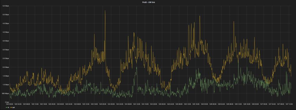
The throughput link to campus shows the effect of the increased traffic to (green) and from (gold) the web server that hosts the CIMSS Tropical Cyclones web site (tropic.ssec.wisc.edu) on SSEC’s link to campus. Credit: John Lalande, SSEC.
But scientists, agencies, and the interested public were relying on other CIMSS web sites, too. The CIMSS Satellite Blog, which disseminates large weather animations and images with explanations and analyses suitable for a broad range of professional and lay audiences, averaged more than 21,000 unique site views and an uptick in data transfer during Hurricane Matthew.
A GOES-13 water vapor animation of Hurricane Matthew (below) across its life cycle (29 September 2016 to 9 October 2016), was the most visited URL on the CIMSS Satellite Blog during the period with nearly 24,000 hits.
“
”The CIMSS Tropical Cyclones web site and the CIMSS Satellite Blog are crucial to meteorologists at United States operational forecast centers during high-impact tropical cyclone events, providing time-sensitive data analysis, products, and interpretation of these events.
The influence of computing infrastructure can sometimes be underestimated or overlooked, but its impact is never more apparent than during natural disasters when information and communication are key. With that in mind, SSEC’s technical computing team has constructed an agile system capable of meeting peak demand, allowing researchers and users to focus on providing data and analyses that decision-makers and the public need to stay safe.
By Jean Phillips
Featured image: MODIS image of Hurricane Matthew on 7 October 2016. Credit: SSEC.