9.5. Creating AMSR2 Reprojections
This example walks through some common tasks when working with GCOM-W1 AMSR2 Level 1B data.
9.5.1. Creating AMSR2 GeoTIFF files
Find the options available for creating AMSR2 Level 1B GeoTIFFs:
polar2grid.sh -r amsr2_l1b -w geotiff -h
List all of the products that can be created from your AMSR2 HDF5 dataset:
polar2grid.sh -r amsr2_l1b -w geotiff --list-products-all -f <path_to_l1b_file>
To create AMSR2 GeoTIFF files of all default bands found in your data set and reprojected to the default Platte Carrée projection:
polar2grid.sh -r amsr2_l1b -w geotiff -f <path_to_l1b_file>
Create the default set of GeoTIFF images for the AMSR2 Level 1B file acquired on 10 September 2022, at 23:35 UTC:
polar2grid.sh -r amsr2_l1b -w geotiff --fill-value 0 -f GW1AM2_202209102335_181A_L1DLBTBR_1110110.h5
Executing this command produces these files in WGS84 (Platte Carrée) projection:
gcom-w1_amsr2_btemp_36.5h_20220910_233500_wgs84_fit.tif
gcom-w1_amsr2_btemp_36.5v_20220910_233500_wgs84_fit.tif
gcom-w1_amsr2_btemp_89.0ah_20220910_233500_wgs84_fit.tif
gcom-w1_amsr2_btemp_89.0av_20220910_233500_wgs84_fit.tif
gcom-w1_amsr2_btemp_89.0bh_20220910_233500_wgs84_fit.tif
gcom-w1_amsr2_btemp_89.0bv_20220910_233500_wgs84_fit.tif
The GeoTIFF image for AMSR2 89.0ah GHz band is displayed below.
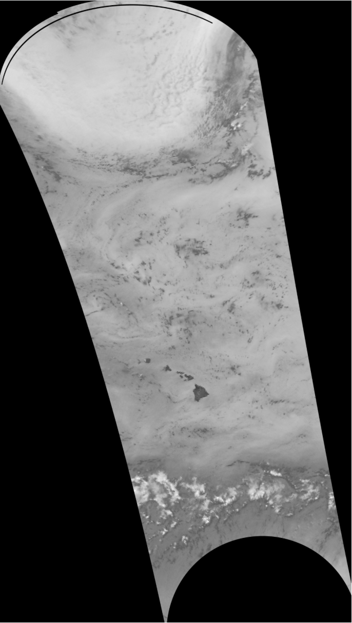
Fig. 9.20 GCOMW-1 AMSR2 L1B 89.0ah GHz brightness temperatures using default scaling. Data set was observed at 23:35 UTC on 10 Setember 2022.
9.5.2. Naval Research Lab (NRL) Image Reproductions
Polar2Grid inclues the capability to reproduce the AMSR2 color enhanced images staged on the the Naval Research Lab (NRL) tropical cyclone page: http://www.nrlmry.navy.mil/TC.html
First, create a reprojected GeoTIFF in Lambert Conic Conformal (LCC) projection and rescale the data. The data in this example is from 10 September 2022. We are pointing to the rescale information that is stored in the $POLAR2GRID_HOME/example_enhancements/amsr2_png/enhancements/generic.yaml file. This will produce a linear scaled output of data ranging from 180.0 K to 280.0 K brightness temperatures for our default products.
polar2grid.sh -r amsr2_l1b -w geotiff --extra-config-path $POLAR2GRID_HOME/example_enhancements/amsr2_png -g lcc_fit --fill-value 0 -f GW1AM2_202209102335_181A_L1DLBTBR_1110110.h5
Executing this command produces these AMSR2 LCC GeoTIFF files:
gcom-w1_amsr2_btemp_36.5h_20220910_233500_lcc_fit.tif
gcom-w1_amsr2_btemp_36.5v_20220910_233500_lcc_fit.tif
gcom-w1_amsr2_btemp_89.0ah_20220910_233500_lcc_fit.tif
gcom-w1_amsr2_btemp_89.0av_20220910_233500_lcc_fit.tif
gcom-w1_amsr2_btemp_89.0bh_20220910_233500_lcc_fit.tif
gcom-w1_amsr2_btemp_89.0bv_20220910_233500_lcc_fit.tif
Once the data has been rescaled, you are ready to apply the NRL colormaps to the data. In this example we are using the 89A/H GHz file. There is also a 36 GHz colormap that can be used.
add_colormap.sh $POLAR2GRID_HOME/libexec/python_runtime/lib/python3.11/site-packages/polar2grid/etc/colormaps/amsr2_89h.cmap gcom-w1_amsr2_btemp_89.0ah_20220910_233500_lcc_fit.tif
This command adds the enhancement to the original GeoTIFF. The rescaled and final color enhanced product are shown below:
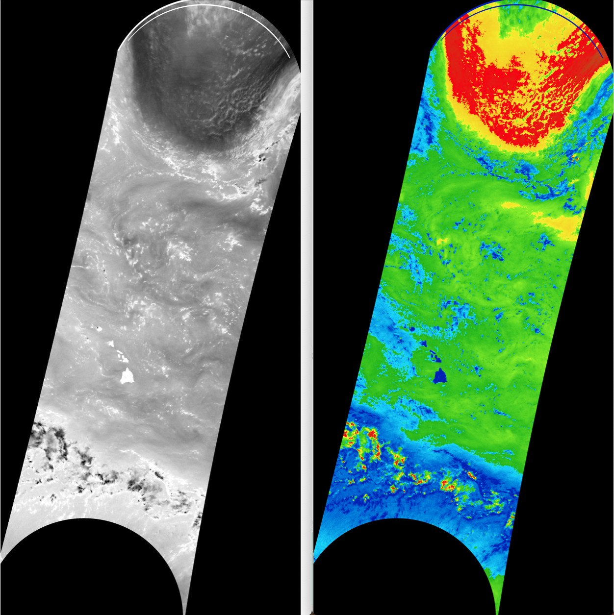
Fig. 9.21 GCOMW-1 AMSR2 L1B 89.0A/H GHz brightness temperatures reprojected in Lambert Conic Conformal Projection and rescaled (left), and with a color table applied (right) using the Naval Research Lab color ehancement. The data set was collected at 23:35 UTC on 10 September 2022.