6.1. AWIPS Tiled Writer
The AWIPS Tiled writer is used to create AWIPS compatible tiled NetCDF4 files.
The Advanced Weather Interactive Processing System (AWIPS) is a program used by the United States National Weather Service (NWS) and others to display and analyze data relevant to meteorology. Sectorized Cloud and Moisture Imagery (SCMI) is a NetCDF4 format accepted by AWIPS to store one image broken up into one or more “tiles”. This format has been used to support additional products over time and so this writer is now called “awips_tiled” to refer to the generic use of these files. Once AWIPS is configured for specific products the AWIPS Tiled writer can be used to provide compatible products to the system. The files created by this writer are compatible with AWIPS II.
The writer takes remapped image data and creates an AWIPS-compatible NetCDF4 file. The writer and the AWIPS client may need to be configured to make things appear the way the user wants in the AWIPS client. The writer can only produce files for datasets mapped to areas with specific projections:
Lambert Conformal Conic (+proj=lcc)
Geostationary (+proj=geos)
Mercator (+proj=merc)
Polar Stereographic (+proj=stere)
This is a limitation of the AWIPS client and not of the writer.
6.1.1. Numbered versus Lettered Grids
By default the writer will save tiles by number starting with ‘1’ representing the upper-left image tile. Tile numbers then increase along the column and then on to the next row.
By specifying --letters on the command line, tiles can be designated with a
letter. Lettered grids or sectors are preconfigured in the writer
configuration file (awips_tiled.yaml in SatPy). The lettered tile locations are
static and will not change with the data being written to them. Each lettered
tile is split in to a certain number of subtiles (–letter-subtiles),
default 2 rows by 2 columns. Lettered tiles are meant to make it easier for
receiving AWIPS clients/stations to filter what tiles they receive; saving
time, bandwidth, and space.
Tiles (numbered or lettered) not containing any valid data are not created.
Warning
The writer does not default to using any grid. Therefore, it is recommended to specify one or more grids for remapping by using the -g flag.
For more detailed information on templates and other options for this writer
see the Satpy documentation here.
6.1.2. Command Line Arguments
usage: |script| -r <reader> -w awips_tiled [-h] [--compress] [--output-filename FILENAME] [--use-end-time] [--use-sector-reference] [--tiles TILE_COUNT TILE_COUNT] [--tile-size TILE_SIZE TILE_SIZE] [--letters]
                                           [--letter-subtiles LETTER_SUBTILES LETTER_SUBTILES] [--source-name SOURCE_NAME] [--sector-id SECTOR_ID] [--template TEMPLATE] [--environment-prefix ENVIRONMENT_PREFIX]
                                           [--check-categories | --no-check-categories]
6.1. AWIPS Tiled Writer
- --compress
zlib compress each netcdf file
Default:
False- --output-filename
custom file pattern to save dataset to
- --use-end-time
use end_time metadata inplace of start_time (useful for multi-day composites)
Default:
False- --use-sector-reference
use the lettered sector location as reference and shift data to match tile pixel locations. Useful when tiles will be updated in future executions. By default the sector tiles are shifted to match the data location. Maximum shift is 0.5 pixels.
Default:
False- --tiles
Number of tiles to produce in Y (rows) and X (cols) direction respectively
Default:
[1, 1]- --tile-size
Specify how many pixels are in each tile (overrides ‘–tiles’)
- --letters
Create tiles from a static letter-based grid based on the product projection
Default:
False- --letter-subtiles
Specify number of subtiles in each lettered tile: ‘row col’
Default:
(2, 2)- --source-name
specify processing source name used in attributes and filename
Default:
'SSEC'- --sector-id
specify name for sector/region used in attributes and filename (example ‘LCC’)
- --template
specify name for pre-configured template used to determine output file structure and formatting.
Default:
'polar'- --environment-prefix
Force value for templates that support an ‘environment_prefix’ in the filename (default ‘OR’).
Default:
'DR'- --check-categories, --no-check-categories
Specify whether category/flag products should be checked for empty tiles. By default (True), tiles consisting entirely of ‘missing’ pixels will not be written. For category products this may not be desired as the missing or invalid value is something users are interested in.
Default:
True
6.1.3. Lettered Sectors

Fig. 6.1 “LCC” Sector Lettered Grid
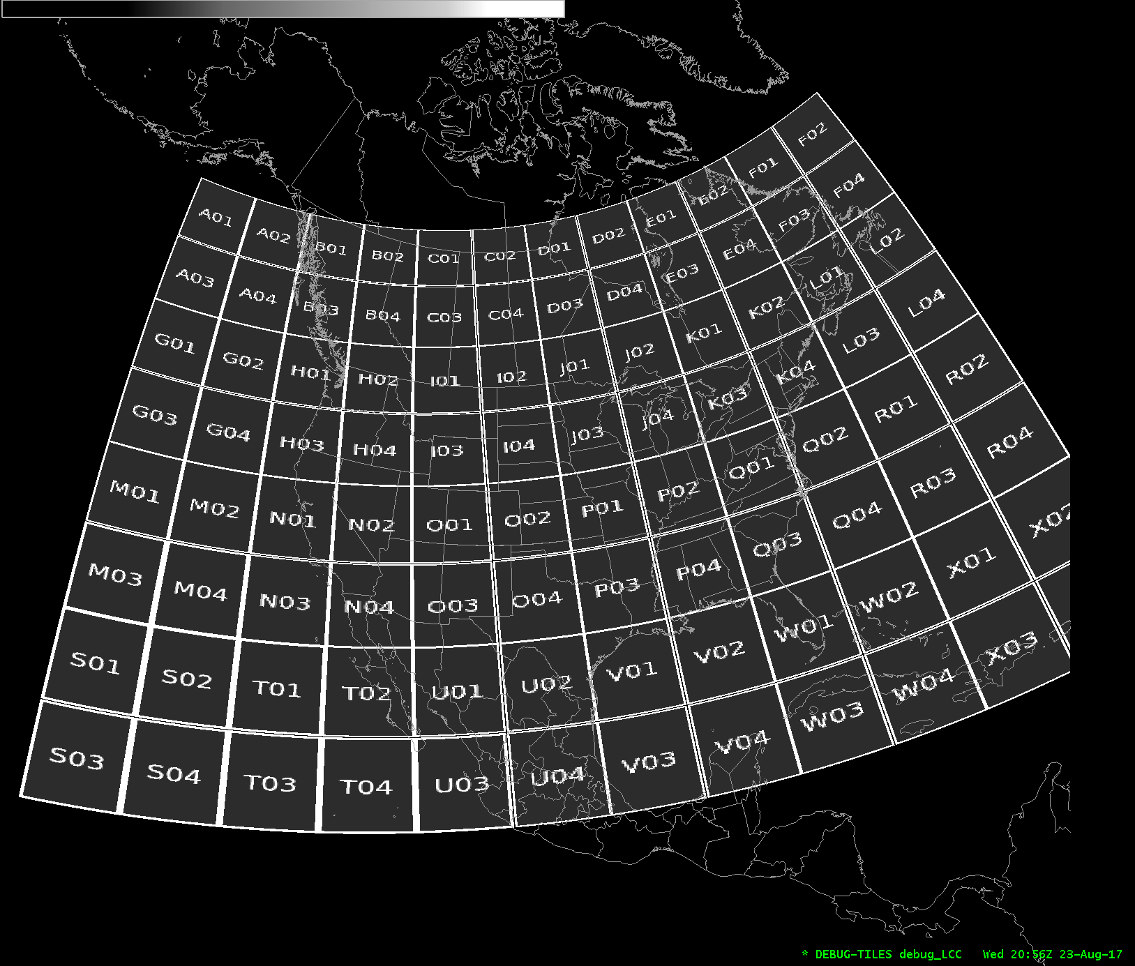

Fig. 6.2 “Pacific” Sector Lettered Grid
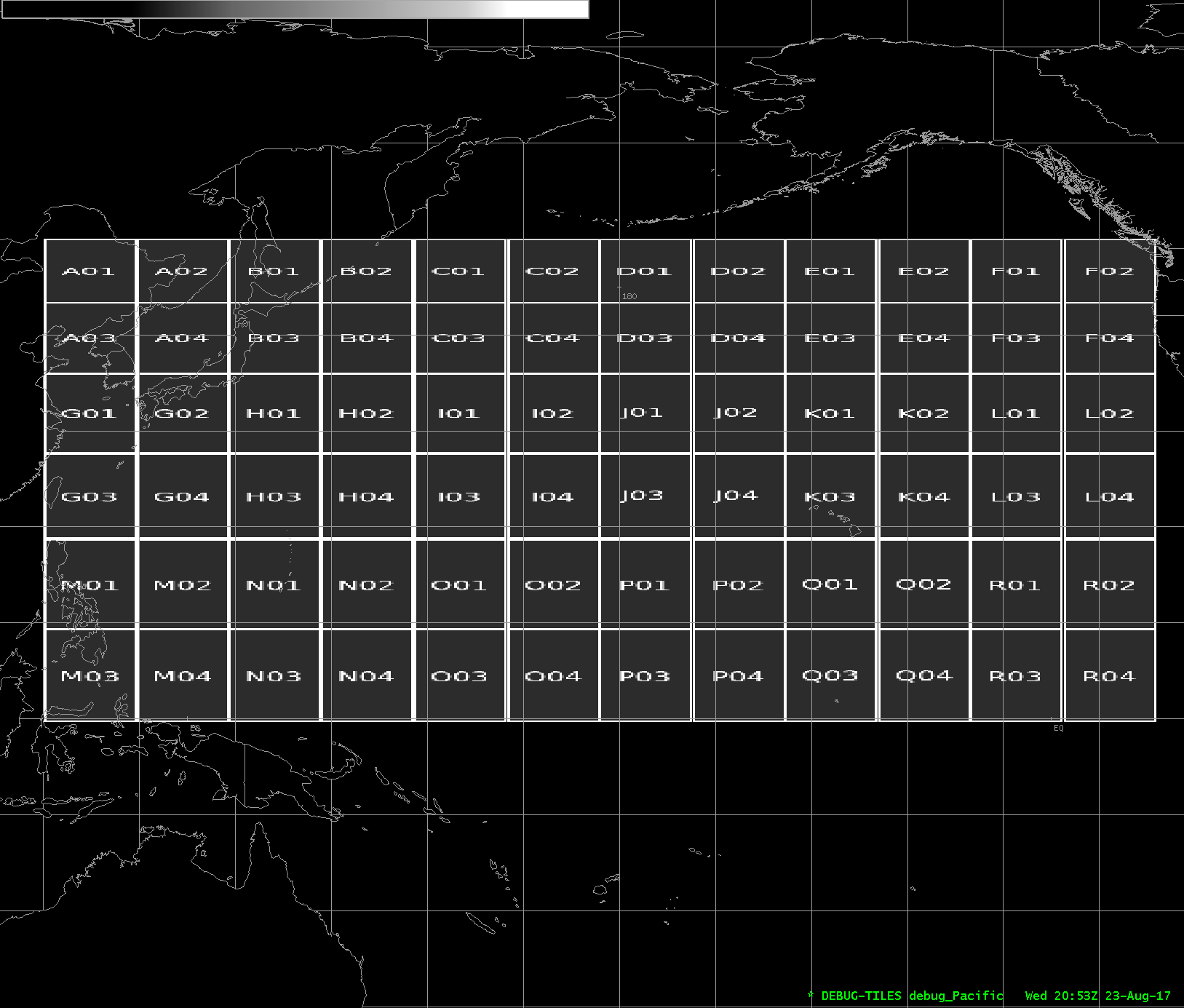
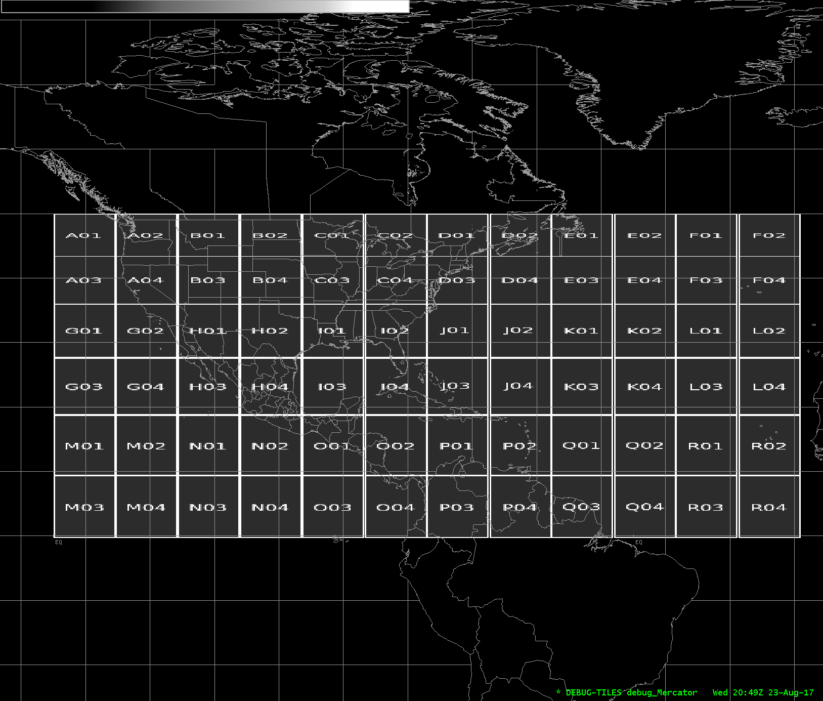
Fig. 6.3 “Mercator” Sector Lettered Grid
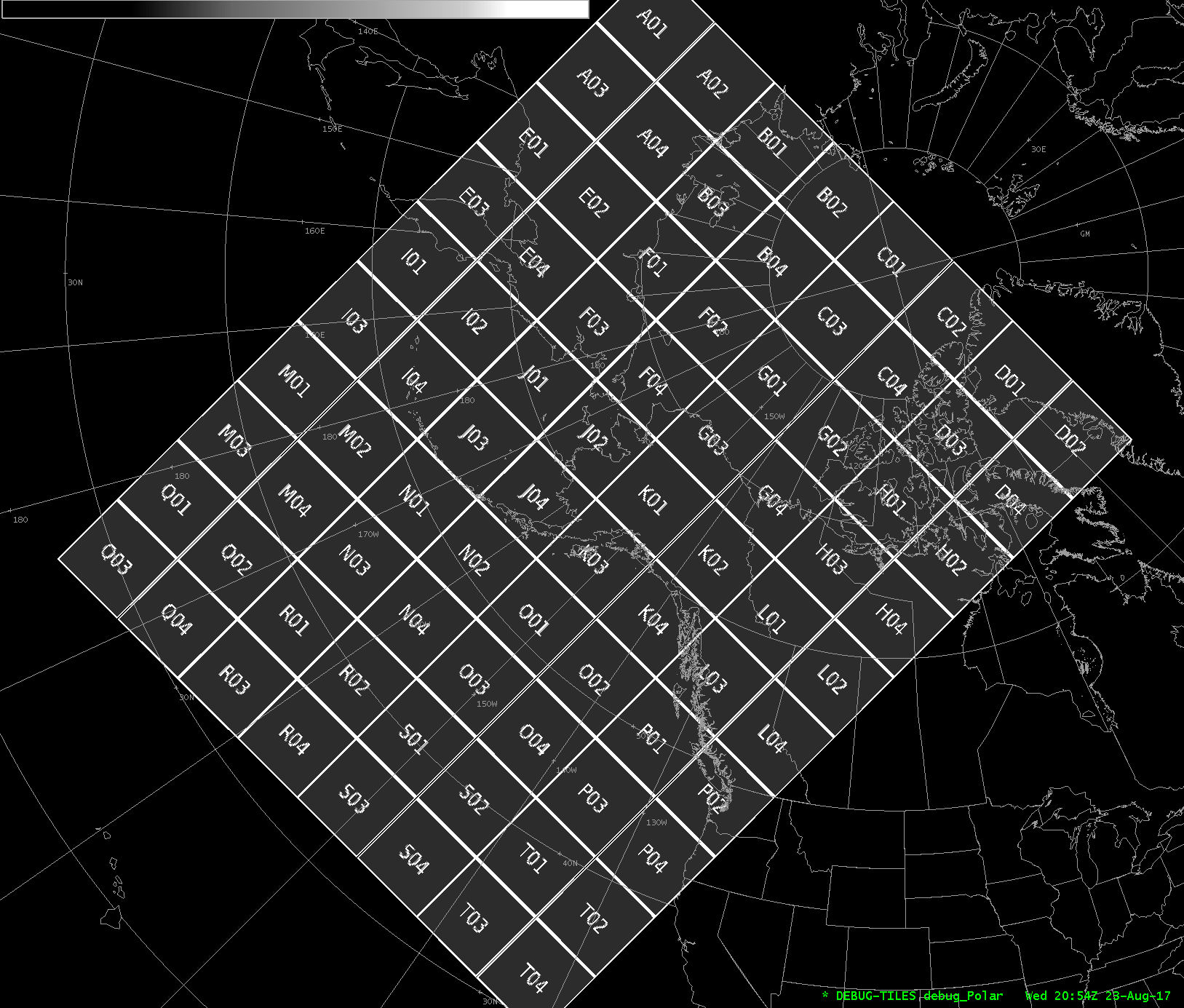
Fig. 6.4 “Polar” Sector Lettered Grid
Examples:
polar2grid.sh -r viirs_sdr -w awips_tiled --awips-true-color --awips-false-color --num-workers 8 -g lcc_conus_300 --sector-id LCC --letters --compress -f viirs/*.h5

polar2grid.sh -r modis_l1b -w awips_tiled -p vis01 bt31 -g lcc_conus_1km --sector-id LCC --letters --compress -f a1.22261.1857.250m.hdf a1.22261.1857.1000m.hdf a1.22261.1857.geo.hdf

polar2grid.sh -r amsr2_l1b -w awips_tiled --num-workers 4 -grid-coverage 0.002 -g polar_alaska_1km --sector-id Polar --letters --compress -f $data_dir/GW1AM2_202209102335_181A_L1DLBTBR_1110110.h5

polar2grid.sh -r amsr2_l1b -w awips_tiled --grid-coverage 0 -g merc_pacific_1km --sector-id Pacific --letters --compress -f GW1AM2_202209120018_188A_L1DLBTBR_1110110.h5

polar2grid.sh -r viirs_edr -w awips_tiled -p AOD -g lcc_conus_300 --sector-id LCC --letters --compress --grid-coverage 0.002 -f JRR-AOD_*.nc

polar2grid.sh -r viirs_edr -w awips_tiled -p NDVI -g lcc_conus_300 --sector-id LCC --letters --compress --grid-coverage 0.002 --maximum-weight-mode -f SurfRefl*.nc

polar2grid.sh -r acspo -w awips_tiled --num-workers 8 --grid-coverage 0 -g lcc_conus_750 --sector-id LCC --letters --compress --method ewa --weight-delta-max 40.0 --weight-distance-max 1.0 -f $data_dir/202*VIIRS_NPP-ACSPO_V2.80*.nc