


Research
Recent Research Activities
Studying Global Cloud Cover Changes
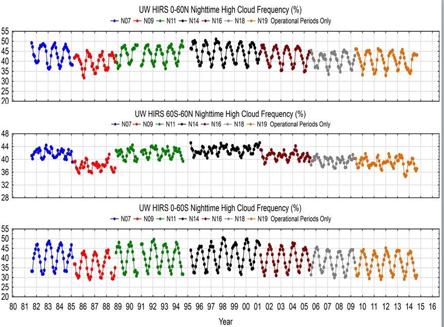
Seasonal changes in global cloud cover are being monitored with multi-spectral observations from the sixteen polar orbiting HIRS (High resolution Infrared Radiation Sounder) since December 1978 (Menzel et al., 2016). The HIRS longwave infrared data have a higher sensitivity to semi-transparent cirrus clouds than visible and infrared window techniques. Cloud top pressure (CTP) and effective emissivity (εf, cloud emissivity multiplied by cloud fraction) have been derived using the 15-µm spectral bands in the CO2 absorption band and implementing the CO2 slicing technique; the approach is robust for high semi-transparent clouds but weak for low clouds with little thermal contrast from clear sky radiances. To mitigate sensor to sensor calibration differences, the Metop-A HIRS has been calibrated using the Metop-A IASI (Infrared Advanced Sounding Interferometer) thus creating a reference HIRS for all others to be calibrated against via simultaneous nadir overpasses; spectral response function have been shifted to create a more cohesive data record. Incorporation of a cloud mask from the higher spatial resolution AVHRR (Advanced Very High Resolution Radiometer) has improved the sub-pixel cloud detection within the HIRS measurements. In the reprocessing of the HIRS data record clouds are found in 76.5% of all HIRS observations from 60 N to 60 S; high clouds are observed in 36% of the observations. Closer investigation of the tropics indicates that there has been little overall change in the global total cloud cover. It appears that high cloud cover changes are mostly caused by larger weather systems. Since 2000, the Moderate resolution Imaging Spectro-radiometer (MODIS) is generating another cloud data set that is being compared connected with the HIRS cloud data (Menzel et al 2008).
Investigating the cloud profiles with high spectral resolution data
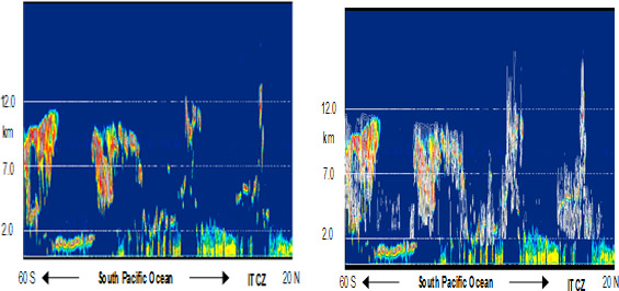
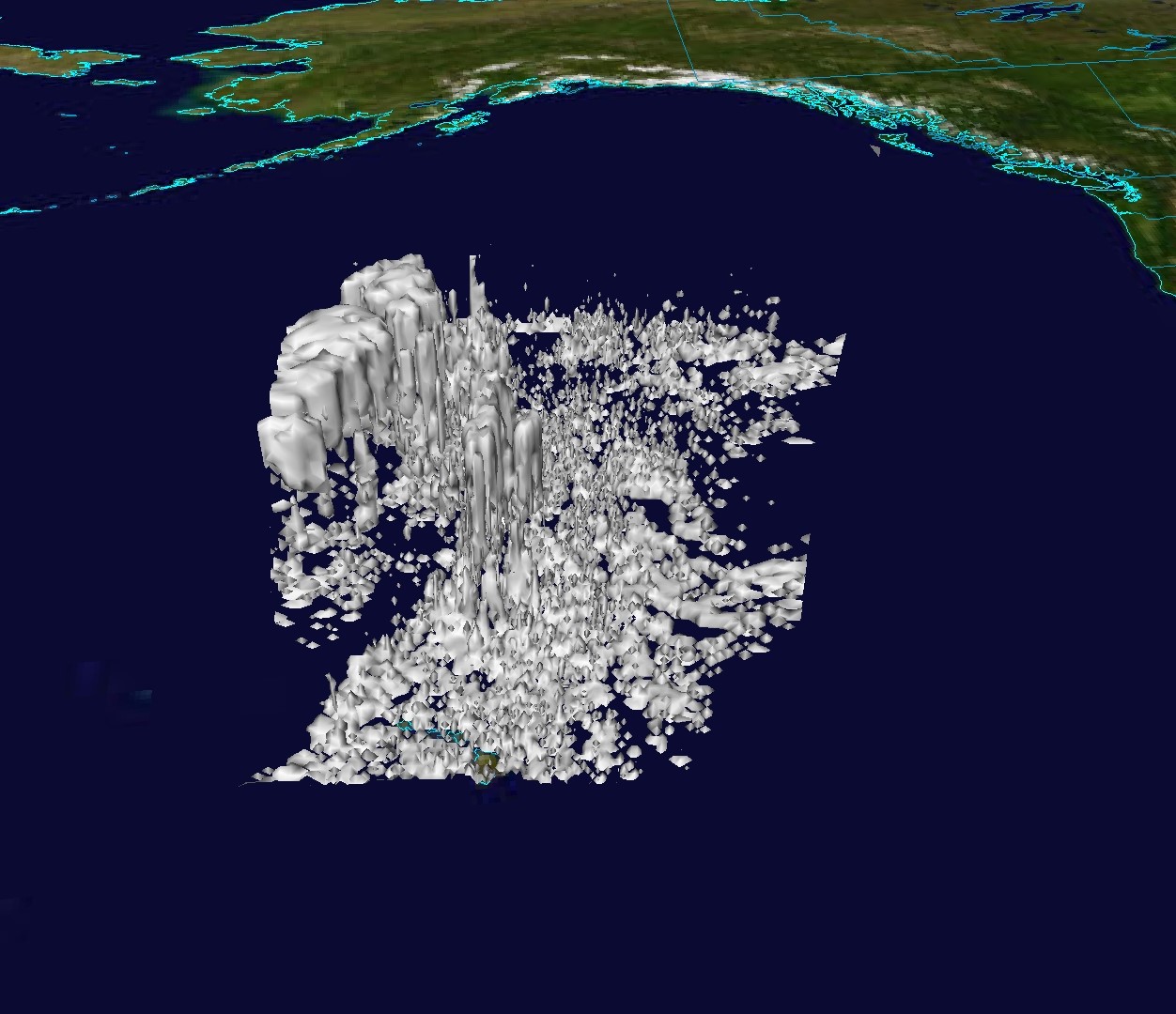
Plokhenko and Menzel are studying opportunities for 3-dimensional cloud property characterization using the combination of vertical cloud structure determined by AIRS high spectral resolution infrared measurements and MODIS high horizontal resolution measurements when semi-transparent high clouds cover lower clouds. Using a cloud radiative transfer model wherein cloud amount and cloud top pressure are adjusted in each of 25 levels (spaced to provide uniform vertical resolution as much as possible) to match calculated with measured radiances for the AIRS spectral bands, cloud amount profiles are estimated. Comparisons with Calipso cloud determinations are showing strong agreement; McIDAS-V 3D images are providing interesting depiction of the vertical distribution sof clouds.
Creating Sounder Radiances and Products at Imager Spatial Resolution
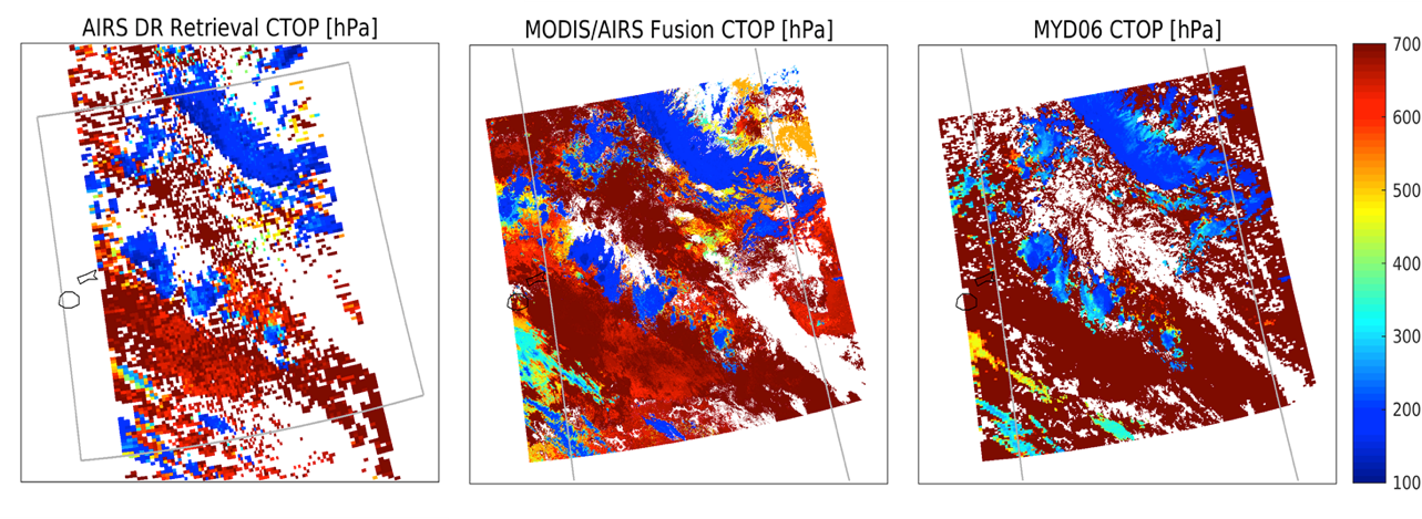
Wesiz, Baum, and Menzel have developed an approach (called Imager/Sounder Fusion) to construct high spatial resolution spectral bands for VIIRS in the CO2 (MODIS bands 24, 25 and 33-36), the O3 (MODIS band 30), and the H2O (MODIS bands 27 and 28) spectrally sensitive regions. The approach (Weisz et al., 2017, Cross et al., 2013) involves first finding a relationship between the high spatial resolution VIIRS IR window bands and the lower spatial resolution CrIS fields of view (FOVs). The relationship is determined for each imager granule using a k-d tree (i.e., multidimensional) search that associates each imager pixel with N nearby sounder FOVs where the radiances match closely; currently N is chosen to be 5. Hyperspectral Sounder radiances are convolved using the desired spectral response function and the N resulting radiances are averaged to construct the chosen spectral band radiance for each imager pixel. The same approach is also being implemented for creating sounder products at imager resolution. Initial testing was performed with the AIRS radiances converted to MODIS spatial resotuion (and validated against actual MODIS measurements).
Remote Sensing Lectures
A series of lectures on remote sensing have been offered by in Madison, WI, Jan 2018; Madison, WI, Jun 2013; Potenza, Italy, Jun 2012; Brienza, Italy Sep 2011; New Delhi, India Feb 2011; Sasso di Castaldo, Italy Jul 2009; Perth, Australia Jan 2009; Istanbul, Turkey Oct 2008; Monteponi, Sardenia Sep 2008; Benevento, Italy Jun 2007; Ostuni, Italy Jun 2006; Krakow, Poland May 2006; Bertinoro, Italy Sep 2004, Maratea, Italy May 2003; Rome, Italy Jun 2002; and Bologna, Italy Sep 2001 More than 350 students have attended. The World Meteorological Organization Technical Document "Applications with Meteorological Satellites" authored by Dr. Menzel was used as a text during these lectures. The courses included materials on (a) radiation and the radiative transfer equation, (b) remote sensing of the Earth surface and its atmosphere, (c) instrument considerations, (d) algorithms for detecting and estimating moisture, precipitation, and clouds properties, and (e)ccurrent and future capabilities of the global observing system Fifty hours of classroom work was split between lectures and laboratory exercises that emphasized investigation of high spatial resolution visible and infrared data (from the Moderate resolution Imaging Spectroradiometer, MODIS, Meteosat Second Generation Imager, SEVIRI, GOES Imager ABI, and Visible Infrared Imaging Suite, VIIRS), high spectral resolution infrared data (from the Advanced Infrared Sounder, AIRS, the Infrared Atmospheric Sounding Interferometer, IASI, and the Cross Track Imaging Sounder, CrIS), and microwave sounding data (from the Advanced Technology Microwave Sounder, ATMS) . Homework assignments and classroom tests verified that good progress was made in learning and mastering the materials presented.