McIDAS-X Learning Guide
Version 2020
[Search Manual]
[Table of Contents]
[Go
to Previous]
[Go
to Next]
Grids and Grid Files - Basic Concepts
A grid is a lattice of regularly spaced data points superimposed on a projection
of the earth. Grids can store numerical model data and serve as an interface
between observational data stored in MD files and analyzed data displayed as
contours on a frame. To contour observational data, compute derived parameters,
and display manually digitized radar (MDR) data, etc., the data must first be
interpolated from the observing locations to a uniform latitude, longitude lattice.
McIDAS stores this geographic lattice as a grid.
Grids are stored in grid files, GRIB files or netCDF files. This manual will use a local grib file and real time grib/grid servers in the real time RTGRIDS dataset. McIDAS Grid files use the naming convention GRnnnnnn where nnnnnn is
the six-digit file number. If the file number is less than six digits, I and
D replace the first two digits and zeros precede the number. For example, GR111111
is the name of the file for grid 111111, GRI90112 is the name for grid file 90112,
and GRID0013 is the name for grid file 13. In ADDE, sequences of grid files are
grouped together in a dataset.
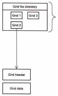
Each grid file contains a grid file directory and up to 10,000 grids. Each grid
contains a grid header and grid data, as shown below. A partial grid dataset directory
and a listing of grid header information are also shown below.
 |
 GRDLIST RTGRIDS/GFS FORM=FILE
 DATASET NAME: RTGRIDS/GFS
  Dataset Position  Creation Date Max Grids         Directory Title
  ----------------  ------------- --------- -------------------------------
        3             2020133      20000   ALL  00Z GFS 0  HR<=VT<=24 HR
        4             2020134      20000   ALL  00Z GFS 0  HR<=VT<=24 HR
        5             2020135      20000   ALL  00Z GFS 0  HR<=VT<=24 HR
       13             2020133      20000   ALL  00Z GFS 24 HR<=VT<=48 HR
       14             2020134      20000   ALL  00Z GFS 24 HR<=VT<=48 HR
|
|
| |
 GRDLIST RTGRIDS/GFS FORM=ALL
 Dataset position 3      Directory Title= ALL  00Z GFS 0  HR<=VT<=24 HR
 PAR  LEVEL      DAY          TIME     SRC  FHR  FDAY         FTIME    GRID  PRO
 ---- ---------- ------------ -------- ---- ---- ------------ -------- ----- ----
 Z      550 MB   12 MAY 20133 00:00:00  GFS    6 12 MAY 20133 06:00:00     1 LAMB
 Total pts=   6045 Num rows=  65  Num columns=  93   received:  2020133 033333Z
 Geopotential height
 GRIB ID numbers: Geographic =  211; PAR =  7; Model ID = 96; Level type =100
 Units of gridded variable are GPM  Scale of variable is:   2
 Lambert Conformal Tangent Cone Projection
 Row num of pole= -113.34  Col num of pole=   53.00  Col spacing (m)= 81270.0
 Standard Latitudes=   25.00     25.00   Standard Longitude=   95.00
 Number of grids listed = 1
 GRDLIST - done
|
|
The GRDLIST and GRDCOPY commands
manipulate individual grids or groups of grids. GRDLIST can
list grids, while GRDCOPY can
copy, move, and perform mathematical operations on grids. These operations
include adding or subtracting two grids, filling a grid with a constant value,
or redefining all values within a grid that are less than a specified number
to be a new number (e.g., all values less than zero are set to zero). If you
have u and v component grids, you can create a vorticity or divergence grid,
or use the grid components to advect a parameter in another grid.
The GRDINFO command provides
information about grids. You can use it to list information about the grid
header and statistics on the grid data, or list data points.
The GRDLIST and GRDCOPY commands
can also manipulate grid files. With these commands you can create, list, or
copy a grid file.
SSEC receives real-time grid data for many numerical models via the NOAAPORT data stream. The models and datasets change frequently so the following list is just a subset of grid dataset names and models that are available.
| ADDE Dataset |
Description |
|
|
| RTGRIDS/ALL |
All model grids decoded by McIDAS-XCD |
| RTGRIDS/AWC-ALL |
National Convective Weather Diagnostic grids |
| RTGRIDS/AWR-ALL |
Alaska Waters Regional Wave Model grids |
| RTGRIDS/ENP-ALL |
Eastern North Pacific Regional Wave Model grids |
| RTGRIDS/FFG-ALL |
NWS Flash Flood Guidance System grids |
| RTGRIDS/GFS-ALL |
Global Forecast System grids |
| RTGRIDS/ICA-ALL |
Ice Concentration Analysis grids |
| RTGRIDS/ICN-ALL |
Current Icing Potential grids |
| RTGRIDS/MDR-ALL |
Manually Digitized Radar grids |
| RTGRIDS/NAM-ALL |
North American Mesoscale Model grids |
| RTGRIDS/NCE-ALL |
NCEP quantitative precipitation forecast grids |
| RTGRIDS/RAP-ALL |
Rapid Refresh model grids |
| RTGRIDS/SST-ALL |
Sea Surface Temp Analysis grids |
| RTGRIDS/UKM-ALL |
Global Coastal Ocean Circulation grids |
| RTGRIDS/WHG-ALL |
Great Lakes wind wave height grids |
| RTGRIDS/WNA-ALL |
Western North Atlantic Regional Wave Model grids |
| RTGRIDS/WWF-ALL |
Global Wind-Wave Forecast grids |
[Search Manual]
[Table of Contents]
[Go
to Previous]
[Go
to Next]