McIDAS-X Learning Guide
Version 2020

[Search Manual] [Table of Contents] [Go to Previous] [Go to Next]


ADDE - Getting Started

The exercise below introduces you to ADDE concepts such as dataset names, aliases, clients and servers. Use this exercise to practice adding entries to your client routing table and local server's mapping table. The image listing, display and copy commands will be explained further in the Satellite Imagery Section.
  1. Start a McIDAS session.
    At the Unix prompt:
    Type:  mcidas -config
    Your session should still be set for six frames from the last time you changed the settings in the Configuration GUI. Set it for twenty frames, save the settings as described in Getting Started.
  2. List your client routing table's groups and associated server IP addresses.
    Type:  DATALOC

    If this is the first time you are using the ADDE, the table is empty and the following listing is displayed.

      
     Group Name                    Server IP Address
     --------------------          ---------------------------------------- 
      
  3. Modify your client routing table so that commands requesting data from a real-time dataset containing free data from Unidata. The group RTGOESR is routed to the Unidata remote server with the IP address ADDE.UCAR.EDU.
    Type:  DATALOC ADD RTGOESR ADDE.UCAR.EDU
  4. List all datasets in the group RTGOESR.
    Type:  DSINFO ALL RTGOESR
  5. List all datasets of type IMAGE in the group RTGOESR.
    Type:  DSINFO I RTGOESR

    Note that instead of the full word, 'IMAGE,' only an I is used. Each parameter in DSINFO can be abbreviated with its first letter instead of writing it out in its entirety.

    The first part of the listing is displayed below. The NumPos value is the number of positions in the dataset. When setting up servers with newer data types, NumPos of 99999 usually means that the server can access an unlimited number of files on the remote machine.

      
              Dataset Names of Type:  IMAGE in Group:  RTGOESR   
                                                               
     Name         NumPos   Content                             
     ------------ ------   -------------------------------------- 
     CONUS        99999    GOES-East CONUS all bands                                              
     CONUSC01     99999    GOES-East CONUS 0.47 um VIS aerosol-over-land                          
     CONUSC02     99999    GOES-East CONUS 0.64 um VIS clouds fog/insol/winds                     
     CONUSC03     99999    GOES-East CONUS 0.86 um Near IR veg/burn scar/aerosol                  
     CONUSC04     99999    GOES-East CONUS 1.37 um Near IR cirrus cloud                           
     CONUSC05     99999    GOES-East CONUS 1.61 um Near IR cloud phase/snow                       
     CONUSC06     99999    GOES-East CONUS 2.24 um Near IR land/cloud vege/snow                   
     CONUSC07     99999    GOES-East CONUS 3.89 um IR Sfc/cloud/fog/fire/winds                      
      
  6. List the 11 most recent images in the dataset RTGOESR/CONUSC13 in reverse chronological order.
    Type:  IMGLIST RTGOESR/CONUSC13.-10

    The following listing is a sample of what is displayed. The Pos value is the absolute position of the image in the dataset. The image listed first is the most recent image, relative position 0. The next image is the second most recent image, relative position -1...

      
     Image file directory listing for:RTGOESR/CONUSC13              
       Pos Satellite/         Date       Time      Center   Band(s)   
           sensor                                 Lat  Lon           
       --- -------------  ------------  --------  ---- ---- ------------ 
       576  GOES-16       16 SEP 19259  02:16:14    30   87 13
       575  GOES-16       16 SEP 19259  02:11:14    30   87 13  
       574  GOES-16       16 SEP 19259  02:06:14    30   87 13 
    	  
  7. List the two most recent images (positions 0 and -1) in the dataset RTGOESR/FD (all bands are included in this dataset) with expanded information on the available Band (1).
    Type:  IMGLIST RTGOESR/FD.-1 BAND=1

    The following listing is an example of what is displayed. The Pos value is the absolute position of the image in the dataset. The Res values are the resolution of the images' center pixels.

      
     Image file directory listing for:RTGOESR/FD                                                            
     Pos Satellite/         Date       Time      Center      Res (km)   Image_Size                         
         sensor                                 Lat  Lon    Lat   Lon                                      
     --- -------------  ------------  --------  ---- ----  ----- ----- ------------                        
     192  GOES-16       16 SEP 19259  02:10:17     0   75                                                  
       Band: 1    0.47 um VIS aerosol-over-land             1.00  1.00 10848 x10848                        
     191  GOES-16       16 SEP 19259  02:00:17     0   75                                                  
       Band: 1    0.47 um VIS aerosol-over-land             1.00  1.00 10848 x10848                        
    IMGLIST: done
    	  
  8. Create the aliases G16C and G16FD for the dataset names RTGOESR/CONUS and RTGOESR/FD.
    Type:  AKA ADD G16C RTGOESR/CONUS
    Type:  AKA ADD G16FD RTGOESR/FD
  9. List the aliases in your client routing table.
    Type:  AKA

    The following listing is displayed.

      
     Alias Name                     Group/Descriptor
     --------------------           ---------------------------------------- 
     G16C                           RTGOESR/CONUS 
     G16FD                          RTGOESR/FD 
    	
  10. Display the most recent image in the dataset with the alias name G16C. Display the image on frame 1, band 13, centered on Athens, Georgia, and draw a map on it. The AKA listing in step 9 shows that the alias G16C represents dataset RTGOESR/CONUS.
    Type:  IMGDISP G16C 1 BAND=13 STATION=KAHN SF=YES;MAP VH 2
  11. Assign the dataset name MYDATA/IMAGES to all of the areas available on your local workstation.
    Type:  DSSERVE ADD MYDATA/IMAGES AREA 1 9999 "ALL AREA FILES
  12. Use the IMGLIST command to find five empty areas on the local server.
    Type:  IMGLIST MYDATA/IMAGES.4000 4004

    If data exists in this block of areas, move or delete the areas or use the IMGLIST command to find an empty block of 5 areas.
  13. Assign the dataset name MYDATA/TEST-IMAGES to the empty block of areas.
    Type:  DSSERVE ADD MYDATA/TEST-IMAGES AREA 4000 4004 "Scratch areas for testing

    A listing similar to the following is displayed.

      
     Group/Descriptor         Type  Format & Range     RT Comment 
     ------------------------ ----- ------------------ -- --------------------
     MYDATA/IMAGES            IMAGE AREA 1-9999           ALL AREA FILES
     MYDATA/TEST-IMAGES       IMAGE AREA 4000-4004        Scratch areas for testing 
    	  
  14. List the groups in your client routing table.
    Type:  DATALOC

    A listing similar to the following is displayed.

      
     Group Name                    Server IP Address
     --------------------          ----------------------------------------
     RTGOESR                       ADDE.UCAR.EDU 
     MYDATA                        <LOCAL-DATA>
    
     <LOCAL-DATA> indicates that data will be accessed from the local data directory. 
    	
    
  15. Create the alias TI for the dataset name MYDATA/TEST-IMAGES.
    Type:  AKA ADD TI MYDATA/TEST-IMAGES
  16. List the aliases in your client routing table.
    Type:  AKA

    The following listing is displayed.

      
      Alias Name                   Group/Descriptor
     --------------------          ---------------------------------------- 
     G16C                          RTGOESR/CONUS
     G16FD                         RTGOESR/FD
     TI                            MYDATA/TEST-IMAGES
    	
  17. List all the images in the dataset with the alias name TI. The AKA listing in step 16 shows that the alias TI represents dataset MYDATA/TEST-IMAGES.
    Type:  IMGLIST TI.ALL

    The following output is displayed because the dataset has no images.

      
     Image file directory listing for:TI
     IMGLIST: No images satisfy the selection criteria 
    	
  18. Copy the most recent image in the dataset with the alias name G16C to position 5 in the dataset with the alias name TI. Copy band 13 and place Athens, Georgia, at its center. The AKA listing in step 16 shows that the aliases G16C and TI represent datasets RTGOESR/CONUS and MYDATA/TEST-IMAGES.
    Type:  IMGCOPY G16C TI.5 STATION=KAHN BAND=13
  19. List all the images in the dataset with the alias name TI.
    Type:  IMGLIST TI.ALL

    An example of the listing is displayed.

      
     Image file directory listing for:TI                            
      Pos Satellite/         Date       Time      Center   Band(s) 
          sensor                                 Lat  Lon         
      --- -------------  ------------  --------  ---- ---- ------------ 
        5  GOES-16       16 SEP 19259  02:10:17    34   83 13
    		 
  20. In addition to the MYDATA/TEST-IMAGES local area file dataset, you can setup local datasets as defined in the DSSERVE help section. In the following exercises you will access GOES-R Series netCDF format files with the IMG* commands by using DSSERVE to assign a dataset name to the files. When doing so, specify "ABIN" in the format parameter, TYPE=IMAGE, and the directory and file masks in the DIRFILE keyword. The files in this exercise are mission-standard Level 1b or Level 2 files in netCDF-4 format, like those from NOAA CLASS or from the GRB data stream after they've been decoded with CSPP Geo or other software. The names of files should look similar to ABI-L1b-RadC-M3C01_G16_s2015229195720.nc (current CSPP Geo naming convention) or OR_ABI-L1b-RadC-M4C16_G16_s20151702215532_e20151702220362_c20151702220394.nc (GOES-R Ground System naming convention).

    Use ftp via web browser or command line instructions below to download the following three files:

    OR_ABI-L1b-RadC-M3C02_G16_s20180041657204_e20180041659577_c20180041700012.nc
    OR_ABI-L1b-RadC-M3C14_G16_s20180041657204_e20180041659577_c20180041700023.nc
    OR_ABI-L2-TPWC-M3_G16_s20180041657204_e20180041659577_c20180041701161.nc


    ftp ftp.ssec.wisc.edu
    login: anonymous
    password: your email
    binary
    prompt
    cd pub/mug/Data/ABI/NetCDF
    mget *.nc
    exit
  21. Create a local dataset with DSSERVE to access the 2 *RadC* ABI netCDF files on your local machine in the directory, <local-path>/Data/ABI/NetCDF.
    Type:  DSSERVE ADD ABI/CONUS ABIN TYPE=IMAGE DIRFILE='<local-path>/Data/ABI/NetCDF/*RadC*'
  22. List the most recent image in the dataset (the default is position 0, so it doesn't need to be specified).
    Type:  IMGLIST ABI/CONUS
  23. Datasets can be organized however the user chooses. Make a dataset that includes all of the files in the data directory.
    Type:  DSSERVE ADD ABI/DATA ABIN TYPE=IMAGE DIRFILE= '<local-path>/Data/ABI/NetCDF/*'
  24. IMGLIST can list the image directory and band information with the FORM=ALL keyword. Your IMGLIST command should match the image.
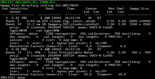
    Type:  IMGLIST ABI/DATA.ALL FORM=ALL

  25. Another IMGLIST keyword, FORM=BAND, lists the band and resolution without the file’s expanded listing.
    Type:  IMGLIST ABI/DATA.1 BAND=2 FORM=BAND
  26. Exit McIDAS.
    Type:  EXIT

[Search Manual] [Table of Contents] [Go to Previous] [Go to Next]