The range rings control displays a set of concentric circles labeled by distance from the central point, with radial lines, useful for judging distance and angle from a geographic location. You display range rings from the Main Display window with the Display->Add Range Rings menu item. Range rings are often used with radar imagery, but they can be used with any data. The control window is composed of two tabs: Location and Settings.
The Location tab allows you to specify the location to center the range rings:
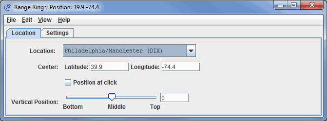
Image 1: Location Tab of the Range Rings Properties Dialog
- Location - Displays range rings centered at the location chosen in the drop-down menu.
- Center - Centers the rings at the entered lat/lon values. Note: West longitudes are negative.
- Position at click - Centers range rings where you left-click in the Main Display window.
- Vertical Position - Sets the vertical position of the range rings with respect to other data being displayed. This can be changed by dragging the slider or typing in a value and pressing Enter.
The Settings tab allows you to control how the range rings are displayed:
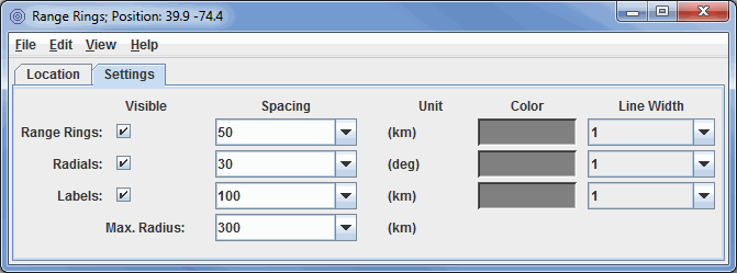
Image 2: Settings Tab of the Range Rings Properties Dialog
The range rings are oriented with local north-south on the displayed map projection. In some cases, the eastward radial line may not be horizontal. The range rings will appear centered on the map projection. You can move the range rings by resetting the latitude-longitude or the station. McIDAS-V can display multiple range rings at once and at any location.
- Visible - Toggles the visibility of the range rings, labels, and radials on and off with the Visible checkboxes. To toggle the entire range ring display at once, use View->Visible checkbox menu item.
- Spacing - Sets the ring spacing, label spacing, and the azimuth interval of the radials using the control window. The values appear in the text fields under Spacing. You can give new values two ways: enter a new value in the text field and press Enter, or click on the pull-down arrow on the right side of the text field to see a list of common values.
- Max. Radius - Sets the maximum radius of the range rings from the center location.
- Unit - Determines the unit that is used for the numerical values in the Spacing and Max. Radius fields.
- Color - Sets the color of the range rings, radials, and labels.
- Line Width - Sets the width of the range rings, radials, and labels.
Many of the menu items seen utilizing this display are standard options that can be found in the Menus section of the Layer Controls page. However, there is one option that is unique to this display.
The Edit menu has this unique option:
- Set Locations - Allows the user to select a specific location, radar site, earthquake location, etc. to center the range rings about.