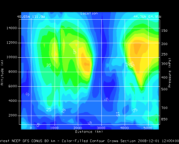
Image 1: Transect View of Wind Speed
The Transect View is a 2-Dimensional display that shows data along a transect line. This type of view can be created through the File->New Display Tab(Window)->Transect Display menu item in the Main Display window.
The left vertical axis shows altitude in meters, the right axis shows pressure levels. The bottom horizontal axis shows distance along the transect. The top horizontal axis shows the latitude and longitude locations of the end points of the transect line drawn in the map display. You can zoom and pan in this display with the normal key and mouse combinations. The transect display will also be duplicated in the Layer Controls tab of the Data Explorer.
To work with a transect display, you must have two tabs/windows open. One of these tabs/windows must have the transect display, and the other must have a standard map display. To control the location of the transect, in the transect display tab, select Transects->Edit. This creates a Transect Drawing Control in the map display. Using the Create a transect Mode, click and drag in the map display to draw the transect. The transect drawn in the transect display will be representative of the most recent transect line you have drawn. You can also select any of the pre-defined or user created transects from the Transects menu of the transect display.
In the Transects tab of the Properties dialog for the Transect View (from View->Properties menu item in the transect display window/tab) you can define a maximum distance to show. Normally, data that lies with the bounding lines that are orthogonal to the transect line is shown in this display. The max distance gives a display radius. Data that lies past this max distance is not displayed.