McIDAS Programmer's Manual
Version 2003
[Search Manual]
[Table of Contents] [Go
to Previous] [Go
to Next]
McIDAS
navigation
All geophysical
data must have a location to be meaningful. McIDAS-X stores geophysical data
in the form closest to its native spatial structure; for example, remotely
sensed data is stored in the image coordinates of the scanner line and element,
while NWP model output is stored as model grid points. Since earth coordinates
(for example, latitude, longitude and height above mean sea level) are easiest
to interpret, McIDAS-X uses a process called navigation to
convert a dataset's native coordinate system to earth coordinates and back
again.
Navigating
datasets implies the ability to transform any dataset into the spatial coordinates
of any other dataset. McIDAS-X' ability to integrate and display a variety
of datasets is made possible by its navigation subsystems.
This
section describes:
- Basic navigation
concepts, such as navigation transforms, subsystems and terminology
- APIs you
will use with the navigation subsystems
- How
to design a navigation type and implement an image navigation module

|
For
more information about McIDAS-X coordinate systems, see Chapter
2, Learning
the Basics. For additional information about map projections,
see Map Projections -- A Working Manual, USGS
Professional Paper 1395, U.S. Government Printing Office, Washington,
1987. |
Basic
concepts
To select and
use the best McIDAS-X navigation subsystem for a given task, you need to understand
the nature of navigation transforms. Navigation systems and transforms are
described below, along with some navigation-specific terminology used throughout
this section.
Navigation
transforms
A navigation
transform is a set of equations for converting a dataset's image or
native coordinates to and from earth coordinates. Each dataset has its
own navigation transform. However, navigation transforms can be grouped
into classes or types. Within a type, the differences
between transforms are quantitative only. Each type has a set of variables,
or parameters, whose values uniquely specify an instance of
that type. For example, the parameters for a tangent cone projection include
the standard latitude and longitude, the scale factor, and the location
of the pole relative to the projection surface's origin.
All navigated
McIDAS-X data has an associated type and a full set of parameters defining
an instance.
Navigation
subsystems
McIDAS-X
uses three navigation subsystems.
- Grid navigation
- Image navigation
- Frame
navigation
Grid
navigation
Grid navigation
converts earth coordinates to and from the row and column locations in the
grid structure. This subsystem is separate from image and frame navigation,
and supports fewer projections These projection types are implemented in
a single set of functions. To add other types, you would have to modify the
functions and recompile all grid applications. Since only a single instance
can be in use at one time, you must repeatedly reinitialize the subsystem
to use multiple projections within an application.
For example,
to compare two grids, A and B, you initialize grid navigation for A, compute
the earth location of a grid point a in A, reinitialize
the subsystem using B's parameters, and transform the earth location of a to
a grid in B. This process is then repeated for every grid point being compared.
Most applications that process or use grids use grid navigation.

|
For
more information about grid projection formats, see the Grid
data section earlier in this chapter. |
Image
navigation
Image navigation
converts image coordinates to and from earth coordinates. Each image navigation
type is implemented in its own source file or module,
and each navigable image dataset has an associated navigation block that
identifies the type and contains a complete set of parameters needed to define
an instance of that type.
Each module
implements the same function names and calling sequence. Since McIDAS-X uses
the type identifier to select the correct module, you can add new types without
modifying existing modules. In addition, up to three instances of navigation,
of the same or different types, can be active simultaneously in a single
application through different slots. This requires
a one- or two-step initialization process before use and is typically used
by applications that work directly with image datasets.
Frame
navigation
Frame navigation
converts frame coordinates to and from earth coordinates. Frame navigation
uses the image navigation subsystem but through a simpler API. It is sufficient
for most applications that just add information to an existing display.
Terminology
This
section contains some navigation-specific terms that may be unfamiliar to
you. They are defined below.
- A conformal
projection is a projection in which angles are preserved; for example,
parallels of latitude and meridians of longitude intersect at right angles.
Conformal projections preserve area at the expense of shape. McIDAS-X
supports Mercator, Lambert conformal, polar stereographic, and tangent-cone
conformal projections. The pseudo-Mercator (latitude/longitude) projection
is not conformal.
- An equal-area
projection is a projection in which areas are preserved; two equal
areas on the Earth are also equal on the projection, even though their
shapes are different. McIDAS-X supports the sinusoidal equal-area projection.
- The geocentric
latitude of a point is the angle between the equatorial plane and
a ray through the point from the Earth's center.
- Geodetic
latitude is the angle between a line perpendicular to the surface
of the geoid through a point and the Earth's equatorial plane. Due to
the Earth's oblateness, geodetic latitudes (the most common form of earth
location) are slightly greater than geocentric latitudes except at the
equator and poles where they are identical.
- A geoid is
the spheroid (surface formed by rotating an ellipse about the polar or
Z axis of the terrestrial coordinate system) that most closely approximates
the Earth's surface.
- A navigation
block is a McIDAS-X data structure containing the projection type
and set of projection parameters needed to compute transformations between
earth and image coordinates. A navigation block is sometimes also called
a navigation codicil.
- A projection is
a set of equations relating earth locations (three variables) to a location
in Cartesian coordinates on the projection plane. Distortions and even
breaks, or interruptions, are unavoidable and are especially prominent
when most or all of the Earth's surface is represented. Some projections
are conformal or equal-area projections. The relationships between satellite
image coordinates and earth coordinates can also be thought of as a projection,
albeit a complicated one.
- Projection
parameters are one or more constants contained in projection equations.
Specifying values for these constants defines an instance of the projection.
- A pseudo-Mercator
projection is a projection in which latitude and longitude vary
uniformly with line (or row) and element (or column). This projection
is distinct from a true Mercator and is neither conformal nor equal-area.
Using
the navigation APIs
The
McIDAS-X library provides Application Program Interfaces for geographic calculations
as well as grid, image and frame navigation. These APIs are described below.
Geographic
calculation API
Many calculations
just require a change from one form of earth or planetary coordinate to another;
for example, changing from a terrestrial (earth-relative) to celestial (star-relative)
coordinate system, or converting a position from a Cartesian to spherical
representation. The table below lists the functions for performing these
tasks.
| Functions |
Description |
m0distnc |
calculates
the great-circle distance on a sphere |
geolat |
performs
geodetic/geocentric latitude conversions |
nllxyz,
nxyzll |
perform
spherical/Cartesian conversions |
raerac,
racrae |
perform
terrestrial/celestial longitude conversions |
solarp |
calculates
solar position |
cartll,
llcart, llobl, llopt |
perform
generic spherical/Cartesian conversions |
Grid
navigation API
The table
below shows the grid navigation API. You will use the grddef function
with the header to initialize the subsystem, then call ijll and llij to
transform grid coordinates to and from earth coordinates, respectively.
| Function |
Description |
grddef |
initializes
the grid transformation |
ijll |
converts
grid coordinates to earth coordinates |
llij |
converts
earth coordinates to grid coordinates |
No API functions
currently exist for creating grid headers for a projection. When creating
McIDAS-X grid files, you must determine the projection to use and then insert
the projection type and parameters into the grid header. The grid header
format is described in the GRIDnnnn data
structure in Chapter 6.
Frame
navigation API
Use the two
functions below to determine the earth coordinates of a pixel or the pixel
location of a point in earth coordinates.
| Function |
Description |
illtv |
converts
earth coordinates to image and frame coordinates |
itvll |
converts
frame coordinates to image and earth coordinates |
The only
prerequisite for these functions is that the frame has navigation associated
with it. The McIDAS-X IMGDISP command
creates frame navigation when it displays an image dataset. The McIDAS-X MAP, PTDISP and GRDDISP commands,
which can define a map base before generating a display, also establish frame
navigation.
The two examples
below assume that frame navigation information exists. The first code fragment
uses the illtv function to convert an earth
location (zlat,zlon) to a frame location (itvlin,itvele),
as is done in the McIDAS-X PC command.
zlat = 43.13
zlon = 89.35

if(illtv(iframe,gnum,zlat,zlon,ilin,iele,itvlin,itvele).ne.0)then
   call edest('unable to navigate point',0)
   return
endif
|
The second
code fragment uses itvll to determine the
earth location of the cursor, as is done in the McIDAS-X E command.
     if( mcmoubtn( 0, left, right, itvlin, itvele ) ) then
C        // handle cursor-positioning error here
     end if
     frame = mcgetimageframenumber()
     rc    = itvll(frame,itvlin,itvele,ilin,iele,rlat,rlon,iscene)
|
Image
navigation API
Use
the appropriate image navigation API functions from the table below if your
application must perform one of these tasks:
- Navigate
image datasets that have not been displayed
- Use navigation
information from an independent source, such as system navigation files
- Make repeated
navigation calculations for more than one dataset
- Use
navigation services other than earth/image coordinate changes, such as
satellite subpoint
| Function |
Description |
nvprep |
dynamically
loads a navigation module for a specified slot, given a set of parameters |
nvset |
initializes
navigation for a specified slot from a specified source |
nvxeas |
converts
earth coordinates to image coordinates; due to dynamic linking, this
function is called nv1eas, nv2eas or nv3eas from applications, depending
on the navigation slot used |
nvxini |
initializes
the navigation module; due to dynamic linking, this function is called
nv1ini, nv2ini or nv3ini from applications, depending on the navigation
slot used |
nvxopt |
performs
special navigation services and is module-dependent; due to dynamic
linking, this function is called nv1opt, nv2opt or nv3opt from applications,
depending on the navigation slot used |
nvxsae |
converts
image coordinates to earth coordinates; due to dynamic linking, this
function is called nv1sae, nv2sae or nv3sae from applications, depending
on the navigation slot used |
To
use image navigation services, the application must do the following:
- Obtain
a navigation block
- Dynamically
link the proper module for the type
- Initialize
an instance of that type in a slot with the parameters
The example
below, from remap.pgm, illustrates the initialization
and use of two instances (slots) of navigation at the same time.
The lines
below assume that navigation blocks were already obtained from the source
(snav) and destination (dnav)
areas. To link the appropriate navigation module to a slot and initialize
it, use nvprep. The lines below initialize
slot 1 for the source and slot 2 for the destination. The nv1ini and nv2ini calls
set the earth coordinate form to Cartesian for both slots.
c --- check for initialization
      if( init.eq.0 ) then
c ------ initialize the source navigation
         if( nvprep( 1, snav(1) ).ne.0 ) then
        navinit = -1
        return
         endif
c ------ initialize the destination navigation
         if( nvprep( 2, dnav(1) ).ne.0 ) then
        navinit = -1
        return
         endif
     init = 1
      endif
c ------ initialize the navigations
c ------ trans can be 'LL  ' for latitude longitude
c ------ or 'XYZ ' for cartesian
      itrans = lit( trans(1:4) )
      call nv1ini(2, itrans)
     call nv2ini(2, itrans)
|
The lines
below map image coordinate (dline,delement)
in the destination image to image coordinate (sline,selement)
in the source image by converting from destination image coordinates to earth
coordinates, then from earth coordinates to source image coordinates.
c --- convert destination line/element to latitude/longitude
      status = nv2sae( dline, delement, 0., dlat, dlon, dz )
      if( status.ne.0 ) then
     crossnav = -1
     return
      endif
c --- convert latitude/longitude to source line/element
      status = nv1eas( dlat, dlon, dz, sline, selement, dz)
      if( status.ne.0 ) then
     crossnav = -2
     return
      endif
|
When the
navigation block source is a local McIDAS-X area format image file or a frame
whose number is known and you only intend to use slot 1, you can use nvset.
It reads the navigation block out of an area or frame and calls nvprep.
| nvset
('AREA', area_num) |
| |
-or- |
| nvset
('FRAME', frame_num) |
In addition
to the commonly used conversions between earth and image coordinates available
through nvxsae and nvxeas,
other special services are available through the nvxopt function.
Some of these services and the modules that support them are listed in the
table below.
| Special services |
Modules that support them |
oblate
radius |
nvxmerc,
nvxps, nvxrect |
orbital
period |
nvxdmsp |
parallax
correction |
nvxgoes,
nvxgvar, nvxmsat |
satellite
location/subpoint |
nvxdmsp,
nvxgoes, nvxgraf, nvxgvar, nvxlamb, nvxmerc, nvxmsat, nvxps, nvxradr,
nvxrect, nvxsin, nvxtiro |
view
angles (satellite, solar, etc.) |
nvxgoes,
nvxgvar |
The
sample code below shows the use of nvxopt.
When using nvxopt, you need to be aware that the input/output can be different
for the different satellite navigations, and you'll have to check the nvx sat.dlm
file to check what is appropriate for input/output.
      real         xin(6)
      real         xout(6)

      ...

C --- initialize slot 1 navigation (navblk is assumed to be
C --- filled with valid parameters)
      if( nvprep( 1, navblk ) .ne.0 ) then
C         (error handler)
      end if

C --- call nvxopt(), and extract the outputs
      if( nv1opt( lit('SPOS'), xin, xout ) .ne.0 ) then
C         (error handler)
      end if

      lat = xout(1)
      lon = xout(2)
|
Implementing
an image navigation module
You can extend
image navigation to include a new type and make it available to all McIDAS-X
commands without changing any applications or existing navigation modules.
This section describes the process for implementing a tangent-cone map projection.
The complete source listing is in the next section titled Example
navigation module code.
Requirements
The
new module must adhere to strict guidelines governing the following:
- Contents
of the navigation block
- Module
name
- Names
and calling sequences of the functions that it implements
- Retention
of parameters between calls
- Response
to invalid inputs
Navigation
block contents
The navigation
block must consist of an array of no more than 640 Fortran integers that
are sufficient to uniquely specify a particular instance of the new navigation
type. The first word of the block must be four ASCII characters that uniquely
identify the type, stored in an integer variable. The block contents are
obvious once the algorithm is fully specified and understood.
Module name
The navigation
module name must be nvxtype.dlm,
where type is the same four characters specified
in the first word of the block. The nvprep function
uses the type from the block to link the application with the correct module.
Functions
The navigation
module must implement the functions nvxini, nvxsae, nvxeas and nvxopt,
with calling sequences following the documentation blocks in the tangent
cone example. In particular, nvxini must
support modes 1 (initialize) and 2 (set earth coordinate mode 'LL' (Latitude-longitude)
or 'XYZ' (Cartesian)). The nvxopt function
must provide, at minimum, an 'SPOS' (subpoint)
service.
Parameters
Between calls,
the navigation module must remember the navigation parameters uniquely defining
an instance. This is typically accomplished by storing these parameters,
and quantities derived from them, in a named common block that is shared
among all four API functions in the module.
Invalid inputs
Satellites
and map projections cannot physically represent all earth locations. The
limits vary from type to type and even from instance to instance. Applications,
therefore, cannot be expected to validate inputs to navigation modules. The
new module must be able to recognize inputs it cannot handle and return an
error status, typically a negative integer.
Algorithms
A navigation
algorithm is a set of equations for mapping McIDAS-X image coordinates to
earth coordinates and vice versa. For satellite navigation types, this typically
involves a lengthy expression in vector notation. Map projections are simpler.
Some manipulation and derivation of additional relationships is often necessary
to extend a published relationship into a full algorithm.
The example
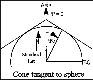
presented here will show the development of a northern hemisphere tangent
cone projection algorithm. The geometry of the tangent cone is shown in Figure
5-6 below. The cone is tangent to the planet at one parallel of latitude
and the planetary axis pierces the apex of the cone. A line between a point
on the Earth's surface and the pole opposite the cone apex maps that point
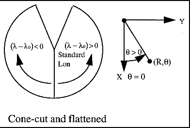
onto the cone. The imaginary cone is then cut along a meridian opposite an
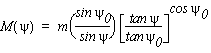
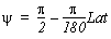
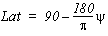
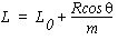
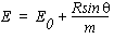
arbitrary standard longitude and flattened. Each point on the Earth's surface
in colatitude ψ and longitude λ corresponds
to a point (R,θ) in polar coordinates on the
flattened cone.
Figure 5-6. Tangent cone projection geometry.
A published form
of the equations defining the location (R,θ)
on the flattened cone in terms of an earth location (ψ,λ)
is:
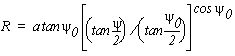 |
(1) |
 |
(2)
|
| Also provided is an equation
for the ratio of the distance between two closely spaced points on the
cone to the distance between the corresponding points on the Earth's surface. |
 |
(3) |
|
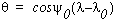
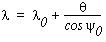
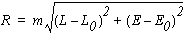
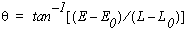
As you can see from (1) and
(2), the planetary radius, a the standard colatitude ψ0,
and the standard longitude λ0 define
an instance of the tangent cone. In equation 3, m is
the map scale expressed as a unitless ratio of projection plane distance
to map distance.
This is not
yet a complete algorithm ready for McIDAS-X implementation. The inverse relationship
capable of converting earth location to projection coordinate (R,θ)
must be derived, the earth location (λ,ψ)
related to its equivalent in McIDAS-X (LAT, LON), and the projection coordinate
(R,θ) related to McIDAS-X image coordinates.
The inverse is: |
 |
|
| and |
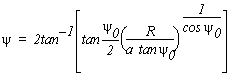 |
(5) |
|
The relationships between
McIDAS-X planetary coordinates and (λ,ψ)
are: |
  |
(6) |
| and |
  |
(7) |
| Those between projection
and image coordinates are: |
  |
(8) |
| and |
 |
(9) |
 |
|
Adding (6) - (9) to make a complete
McIDAS-X navigation algorithm adds additional parameters to make the complete
set ψ0, λ0, m,
L0, and E0, where the latter specify the scale in km
per pixel and the location of the pole of the projection surface in image coordinates.
The last
step before implementation is to examine the completed algorithm for limits
and singularities; these will serve as the basis for input validation. The
limits on the inputs are summarized below.
| Parameters |
|
0 < ψ0 < π/2
-π < λ0 ≤ π |
standard
colatitude is confined to the northern
hemisphere
standard longitude must
be a legal value |
| Earth
coordinates |
|
0 ≤ ψ < π
-π < λ ≤ π |
all colatitudes are navigable
except the south pole; note that map scale M(ψ) is undefined at
the north pole,
however all longitudes are navigable |
| Image
coordinates |
| R ≥ 0
π cos(ψ0) < θ ≤ π cos( ψ0) |
no
valid earth location maps to -R
area in the split region
of the flattened cone
isn't navigable; exclude it as input |
Implementation
Implementing
the navigation module consists of three steps:
- Specifying
the navigation block format
- Creating
or modifying the routines and applications that will create instances of
the new type
- creating
the navigation module for the new type
Each of these
steps is discussed below.
Defining the
navigation block
The
contents of the navigation block follow directly from the parameters provided
in the previous Algorithms section. The five parameters
are:
- Standard
latitude
- Standard
longitude
- Pole line
- Pole element
- Scale
A sixth parameter,
planetary radius, could also be added but is not included in the examples.
The parameters can be represented in different ways, such as standard colatitude
in place of latitude. However, since the applications will create navigation
blocks, you should use units and quantities convenient for McIDAS-X, as shown
in the lines of code below. This code is taken from the documentation block
at the beginning of nvxini and is shown
in lines 0017 through 0022 in the complete source listing that follows.
*$   param( 1) = 'TANC'
*$   param( 2) = image line of pole   *10000
*$   param( 3) = image element of pole*10000
*$   param( 4) = km per pixel         *10000
*$   param( 6) = standard latitude    *10000
*$   param( 7) = standard longitude   *10000
|
All instances
of 'TANC' navigation must be specified with
these parameters.
Creating navigation
blocks in applications
Applications
that create navigation blocks must provide values for a complete set of parameters.
Sometimes they must be derived from user inputs using the navigation transformation
itself. Below is a code fragment from an application (not the navigation
module itself) that creates a tangent-cone navigation block. It assumes that
the center latitude and longitude (clat and clon),
the standard latitude and longitude (slat and slon),
and the scale of standard latitude (sscale),
in km per pixel, are already provided. First, the earth locations are converted
from McIDAS-X to projection form.
    psi   = PI/2.d0 - D2R*clat
    psi_0 = PI/2.d0 - D2R*slat
    lam   =         - D2R*clon
    lam_0 =         - D2R*slon
|
Next, the
radius of the specified image coordinate center point (relative to the projection
center or the pole) is computed.
    radius = A * tan(psi_0) *
$       (tan(psi/2.d0)/tan(psi_0/2.d0))**cos(psi_0)
    theta  = cos(psi_0)*(lam-lam_0)
|
Then the
pole's image coordinate is computed using simple trigonometry.
    call status = mcfsize(mcgetimageframenumber, nlins, neles)
    lin_c  = dble(nlins) / 2.d0
    ele_c  = dble(neles) / 2.d0


    lin_0  = lin_c - radius*cos(theta)/sscale
    ele_0  = ele_c - radius*sin(theta)/sscale
|
Once the
parameters are computed, the navigation block can be filled and written either
to the image dataset:
C   // Create and insert the navigation block

    nvblk( 1) = lit('TANC') ! Tangent Cone nav type
    nvblk( 2) = nint(10000*lin_0)   ! image line of pole
    nvblk( 3) = nint(10000*ele_0)   ! image element of pole
    nvblk( 4) = nint(10000*sscale)  ! scale km/pixel at slat
    nvblk( 5) = nint(10000*slat)    ! standard latitude
    nvblk( 6) = nint(10000*slon)    ! standard longitude

    status = mcaput(dataset, nsort, sort, adir, nvblk, calblk)
|
or a McIDAS-X
area format image file:
call araput(aranum,4*DIRSIZ,4*NVWDS,nvblk)
|
Creating the
navigation module
If the algorithm
and navigation block are complete and unambiguous, implementing a map projection
as a McIDAS-X navigation module is generally straightforward. Your major
design decision is what to store in the common block. At minimum, you should
include the navigation parameters or quantities derived from them without
loss of information. This is necessary for the module to remember the characteristics
of the instance.
Because navigation
modules are called many times, you should precompute additional quantities
in the initialization routine nvxini and
store them in common, especially if doing so eliminates trigonometric function
calls in the other functions. Thus, the variables Coscl, Tancl, Tancl2,
and Mxtheta are included in the common block
below. This code is located in lines 0099 through 0120 of the source listing
that follows.
C     // Common block contents: precomputed intermediate values

      real      Coscl       ! cosine(Colat0)
      real      Tancl       ! tangent(Colat0)
      real      Tancl2      ! tangent(Colat0/2)
      real      Mxtheta     ! limit of angle from std. lon
C               ! on projection surface

C     // Common block contents: constants

      real      D2R     ! degrees to radians factor
      real      Pi
      real      Badreal     ! returned when navigation
C                       ! cannot be done
      real      Erad        ! Earth radius
      logical       Init        ! initialized flag
      logical       Latlon      ! .TRUE. for lat/lon I/O


      COMMON/TANC/ Lin0, Ele0, Scale, Lon0, Colat0,
     &  Coscl, Tancl, Tancl2, Mxtheta,
     &  D2R, Pi, Badreal, Erad, Init, Latlon
|
Also included in the block are physical constants and two flags; Init is
set when nvxini runs successfully, and Latlon is
set if the earth coordinate mode is latitude and longitude rather than Cartesian.
The overall
structure of nvxini is a large if-block
to handle the two options. Option 1 (lines 0144 - 0220 in the source listing)
initializes the instance by range checking the navigation parameters and
precomputing the quantities to retain in the common block. Option 2 (lines
0222 - 0233) sets the earth coordinate mode based on word param(1).
The forward
(image to Earth) navigation routine's one subtlety is input validation. Points
within the split of the projection plane, which is shown in Figure 5-6, are
not navigable.
Recognizing
such points is possible only after the conversion from McIDAS-X image coordinates
to projection coordinates is complete. The code below is from lines 0370
through 0384.
C  // Compute radius and bearing from pole

   dx   = Scale*(lin-Lin0)
   dy   = Scale*(ele-Ele0)

   radius   = sqrt(dx*dx+dy*dy)
   theta    = atan2(dy,dx)


C  // Apply range checking on theta to determine if point is navigable

   if ( theta.le.-Mxtheta .or. theta.gt.Mxtheta ) then
      NVXSAE = -1
      return
   end if
|
When range
checking is done, the projection is inverted and the colatitude and longitude
(in radians, east positive) is converted to latitude and longitude (in degrees,
west positive); see lines 0389 - 0401. A call to nllxyz to
generate Cartesian coordinate output is made if the Latlon flag
was cleared by an earlier call to nvxini (line
0404). Inverse (earth-to-image) navigation in nvxeas follows
a similar pattern, except the earth-coordinate option must be handled at
the beginning (line 0544).
The nvxopt function
performs special services. Since the contents of the argument vector depend
on the option selected, the routine consists of a large if-block (lines 0716
- 0742) with one branch per recognized option and the necessary input validation
done within each branch. As in nvxini,
the code must be able to recognize options that it doesn't know and return
an appropriate error status. All core McIDAS-X navigation modules have an SPOS option
that returns the subpoint at a given time (for satellites) or the latitude
and longitude of the center (maps). The example that follows implements only
an SCAL to return the map scale factor at any
latitude.

Example
navigation module code
0001    C   THIS IS SSEC PROPRIETARY SOFTWARE - ITS USE IS RESTRICTED.
0002
0003    C *** McIDAS Revision History ***
0004    C *** McIDAS Revision History ***
0005
0006    *$ Name:
0007    *$  nvxini - Initialize navigation for tangent cone projection
0008    *$
0009    *$ Interface:
0010    *$  integer function
0011    *$  nvxint(integer option, integer param(*))
0012    *$
0013    *$ Input:
0014    *$  option  - 1 to set or change projection parameters
0015    *$  option  - 2 set output option
0016    *$  param   - For option 1:
0017    *$        param( 1) = 'TANC'
0018    *$        param( 2) = image line    of pole*10000
0019    *$        param( 3) = image element of pole*10000
0020    *$        param( 4) = km per pixel         *10000
0021    *$        param( 6) = standard latitude    *10000
0022    *$        param( 7) = standard longitude   *10000
0023    *$          for option 2:
0024    *$          param( 1) = 'LL' or 'XYZ'
0025    *$
0026    *$ Input and Output:
0027    *$  none
0028    *$
0029    *$ Output:
0030    *$  none
0031    *$
0032    *$ Return values:
0033    *$   0  - success
0034    *$  -3  - invalid or inconsistent navigation parameters
0035    *$  -4  - invalid navigation parameter type
0036    *$  -5  - invalid nvxini() option
0037    *$
0038    *$ Remarks:
0039    *$  Latitudes and longitudes are in degrees, West positive.
0040    *$  Projection parameters must be in the following ranges:
0041    *$      0. <  standard latitude  <  90.
0042    *$      -180. <= standard longitude < 180.
0043    *$      0. <  scale
0044    *$  Accuracy may suffer near the standard latitude limits.
0045    *$
0046    *$  The projection algorithm is adapted from that in
0047    *$  Saucier, W. J. 1989: Principles of meteorological analysis.
0048    *$  Dover Publications, Inc. 433 pp.
0049    *$
0050    *$ Categories:
0051    *$  navigation
0052
0053    C     // CODING CONVENTION note: function declarations and common
0054    C     // block declarations are all capitalized to be recognizable
0055    C     // to script 'convdlm;' this is necessary for a correct build
0056    C     // in MCIDAS-X. For the same reason, avoid referring to
0057    C     // function or common block names in uppercase elsewhere
0058
0059          INTEGER FUNCTION NVXINI(option,param)
0060
0061
0062          implicit      NONE
0063
0064
0065    C     // Interface variables (formal arguments)
0066
0067          integer           option      ! initialization option
0068          integer           param(*)        ! navigation parameters or
0069    C                   ! output coordinate type
0070
0071    C     // Local variable definitions
0072
0073          character*4           navtyp      ! codicil type
0074          character*4           outcoord        ! output coordinate type
0075          real          lat0        ! standard latitude
0076          character*80          cbuf        ! text output buffer
0077
0078
0079
0080    C     /////////////////////////////////////////////////////////
0081    C     Common block variables and declaration.
0082
0083    C     ALL CODE BETWEEN THE '//////' SEPARATORS MUST BE
0084    C     DUPLICATED EXACTLY IN EACH NAVIGATION ROUTINE
0085
0086    C     (A more maintenance-safe version would use ENTRY points
0087    C     rather than separate functions for the navigation API
0088    C     but entry points cannot be processed by 'convdlm.')
0089
0090    C     // Common block contents: projection parameters
0091
0092          real          Lin0        ! image line of pole
0093          real          Ele0        ! image element of pole
0094          real          Scale       ! km per unit image coordinate
0095    C                   ! (pixel)
0096          real          Lon0        ! standard longitude
0097          real          Colat0      ! standard colatitude
0098
0099    C     // Common block contents: precomputed intermediate values
0100
0101          real          Coscl       ! cosine(Colat0)
0102          real          Tancl       ! tangent(Colat0)
0103          real          Tancl2      ! tangent(Colat0/2)
0104          real          Mxtheta     ! limit of angle from std. lon
0105    C                   ! on projection surface
0106
0107    C     // Common block contents: constants
0108
0109          real          D2R     ! degrees to radians factor
0110          real          Pi
0111          real          Badreal     ! returned when navigation
0112    C                   ! cannot be done
0113          real          Erad        ! Earth radius
0114          logical           Init        ! initialized flag
0115          logical           Latlon      ! .TRUE. for lat/lon I/O
0116
0117
0118          COMMON/TANC/ Lin0, Ele0, Scale, Lon0, Colat0,
0119         &  Coscl, Tancl, Tancl2, Mxtheta,
0120         &  D2R, Pi, Badreal, Erad, Init, Latlon
0121
0122    C     End of common block variables and declaration.
0123    C     /////////////////////////////////////////////////////////
0124
0125
0126
0127    C     // Begin initialization process by setting values of constants.
0128
0129          Erad      = 6370.         ! This value of Erad is ok
0130    C                   ! for low precision nav
0131    C                   ! where a spherical Earth is
0132    C                   ! adequate (Saucier, p. 32)
0133          Pi        = acos(-1.)
0134          D2R       = Pi / 180.
0135          Badreal       = -1.E10            ! obvious unreasonable value
0136    C                   ! for nav transform result
0137
0138    C     // Process initialization options. Only one option, initialize
0139    C     // navigation parameters, is supported in this demo version,
0140    C     // but a 'hook' is left for an additional option to set the
0141    C     // output coordinate to something other than lat/lon
0142
0143          if( option.eq.1 ) then
0144
0145             call DDEST('nvxini(tanc) option=1',0)
0146
0147             call movwc(param(1),navtyp)
0148             if( navtyp.eq.'TANC') then
0149
0150    C           // Unpack tangent cone projection parameters
0151
0152                Lin0            = param(2) / 10000.
0153                Ele0            = param(3) / 10000.
0154                Scale           = param(4) / 10000.
0155                lat0            = param(5) / 10000.
0156                Lon0            = param(6) / 10000.
0157
0158                write(cbuf,'('' nvxini: lat0, Lon0 '',2F12.4)')
0159         *        lat0, Lon0
0160                call DDEST(cbuf,0)
0161
0162    C           // apply range checking
0163
0164                if(Scale.le.0. ) then
0165                   call DDEST('nvxini(tanc) scale is negative',0)
0166                   Init         = .FALSE.
0167                   NVXINI           = -3
0168                   return
0169                end if
0170
0171                if(lat0.le.0. .or. lat0.ge.90. ) then
0172                   call DDEST('nvxini(tanc) standard lat out of range',0)
0173                   Init         = .FALSE.
0174                   NVXINI   = -3
0175                   return
0176                end if
0177
0178                if(Lon0.le.-180. .or. Lon0.gt.180. ) then
0179                   call DDEST('nvxini(tanc) standard lon out of range',0)
0180                   Init         = .FALSE.
0181                   NVXINI   = -3
0182                   return
0183                end if
0184
0185    C           // convert degrees to radians and latitude to colatitude.
0186    C           // Account for McIDAS longitude convention
0187
0188                Lon0            = -Lon0 * D2R
0189                Colat0          =  Pi/2. - D2R*lat0
0190
0191                write(cbuf,'('' nvxini:  Colat0, Lon_0 '',2F12.4)')
0192         *        Colat0, Lon0
0193                call DDEST(cbuf,0)
0194
0195    C           // Compute intermediate quantities
0196
0197                Coscl           = cos(Colat0)
0198                Tancl           = tan(Colat0)
0199                Tancl2          = tan(Colat0/2.)
0200                Mxtheta         = Pi*Coscl
0201
0202                write(cbuf,'('' nvxini: Coscl,   Tancl'', 2F7.4)')
0203         *        Coscl, Tancl
0204                call DDEST(cbuf,0)
0205                write(cbuf,'('' nvxini: Tancl2, Mxtheta '', 2F7.4)')
0206         *        tancl2, Mxtheta
0207                call DDEST(cbuf,0)
0208
0209            Latlon      = .TRUE.
0210
0211
0212             else           ! option=1 but type not 'TANC'
0213
0214                call DDEST('nvxini(tanc) parameter type bad',0)
0215                Init            = .FALSE.
0216                NVXINI          = -4
0217                return
0218
0219             end if
0220
0221          else if ( option .eq. 2) then
0222
0223         call movwc(param(1),outcoord)
0224         if( outcoord.eq.'LL' ) then
0225             Latlon     = .TRUE.
0226         else if( outcoord.eq.'XYZ') then
0227             Latlon     = .FALSE.
0228         else
0229                 call DDEST('option=2 coord '//outcoord//' not supported',0)
0230                 Init           = .FALSE.
0231                 NVXINI         = -5
0232         end if
0233
0234          else          ! option not 1 or 2
0235
0236             call DDEST('nvxini(tanc) unrecognized output option ',option)
0237             NVXINI     =  -4
0238             return
0239
0240          end if
0241
0242          NVXINI        = 0
0243          Init      = .TRUE.
0244
0245          return
0246          end
0247
0248
0249
0250
0251    *$ Name:
0252    *$  nvxsae - Compute earth coordinates from image coordinates
0253    *$
0254    *$ Interface:
0255    *$  integer function
0256    *$  nvxsae( real lin, real ele, real dummy,
0257    *$              real e1,  real  e2, real    e3 )
0258    *$
0259    *$ Input:
0260    *$  lin - image line
0261    *$  ele - image element
0262    *$  dummy   - (unused)
0263    *$
0264    *$ Input and Output:
0265    *$  none
0266    *$
0267    *$ Output:
0268    *$  e1  - latitude  or x
0269    *$  e2  - longitude or y
0270    *$  e3  - height    or z
0271    *$
0272    *$ Return values:
0273    *$   0  - success
0274    *$  -1  - input data physically valid but not navigable
0275    *$        given the specified projection
0276    *$  -6  - module not initialized
0277    *$
0278    *$ Remarks:
0279    *$  The navigation module must first be initialized with
0280    *$  a call to nvxini(). The output form (lat,lon) or (x,y,z)
0281    *$  depends on the last call to nvxini() with option 2.
0282    *$
0283    *$ Categories:
0284    *$  navigation
0285
0286          INTEGER FUNCTION NVXSAE( lin, ele, dummy, e1, e2, e3 )
0287
0288          implicit      NONE
0289
0290    C     // Interface variables (formal arguments)
0291
0292          real          lin     ! image line to navigate
0293          real          ele     ! image element to navigate
0294          real          dummy       ! (unused argument)
0295          real          e1      ! Earth coordinate 1
0296          real          e2      ! Earth coordinate 2
0297          real          e3      ! Earth coordinate 3
0298
0299    C     // Local variables
0300
0301          real          lat     ! latitude  (McIDAS convention)
0302          real          lon     ! longitude (McIDAS convention)
0303          real          hgt     ! height
0304          real          dx      ! zonal displacement from pole
0305    C                   ! on projection surface
0306          real          dy      ! meridional displacement from pole
0307          real          radius      ! distance from pole on projection
0308          real          theta       ! angle from standard longitude on
0309    C                   ! projection surface
0310          real          colat       ! colatitude of navigated point
0311
0312
0313    C     ///////////////////////////////////////////////////////
0314    C     Common block variables and declaration.
0315
0316    C     ALL CODE BETWEEN THE '//////' SEPARATORS MUST BE
0317    C     DUPLICATED EXACTLY IN EACH NAVIGATION ROUTINE
0318
0319    C     (A more maintenance-safe version would use ENTRY points
0320    C     rather than separate functions for the navigation API
0321    C     but entry points cannot be processed by 'convdlm.')
0322
0323    C     // Common block contents: projection parameters
0324
0325          real          Lin0        ! image line of pole
0326          real          Ele0        ! image element of pole
0327          real          Scale       ! km per unit image coordinate
0328    C                   ! (pixel)
0329          real          Lon0        ! standard longitude
0330          real          Colat0      ! standard colatitude
0331
0332    C     // Common block contents: pre-computed intermediate values
0333
0334          real          Coscl       ! cosine(Colat0)
0335          real          Tancl       ! tangent(Colat0)
0336          real          Tancl2      ! tangent(Colat0/2)
0337          real          Mxtheta     ! limit of angle from std. lon
0338    C                   ! on projection surface
0339
0340    C     // Common block contents: constants
0341
0342          real          D2R     ! degrees to radians factor
0343          real          Pi
0344          real          Badreal     ! returned when navigation
0345    C                   ! cannot be done
0346          real          Erad        ! Earth radius
0347          logical           Init        ! initialized flag
0348          logical           Latlon      ! .TRUE. for lat/lon I/O
0349
0350          COMMON/TANC/ Lin0, Ele0, Scale, Lon0, Colat0,
0351         &  Coscl, Tancl, Tancl2, Mxtheta,
0352         &  D2R, Pi, Badreal, Erad, Init, Latlon
0353
0354    C     End of common block variables and declaration.
0355    C     ///////////////////////////////////////////////////
0356
0357          e1        = Badreal
0358          e2        = Badreal
0359          e3        = Badreal
0360
0361
0362    C     // verify initialized module
0363
0364          if(.not.Init) then
0365              NVXSAE = -6
0366              return
0367          end if
0368
0369
0370    C     // Compute radius and bearing from pole
0371
0372          dx        = Scale*(lin-Lin0)
0373          dy        = Scale*(ele-Ele0)
0374
0375          radius        = sqrt(dx*dx+dy*dy)
0376          theta     = atan2(dy,dx)
0377
0378
0379    C     // Apply range checking on theta to determine if point is navigable
0380
0381          if ( theta.le.-Mxtheta .or. theta.gt.Mxtheta ) then
0382             NVXSAE = -1
0383             return
0384          end if
0385
0386    C     // Forward navigation: compute longitude and colatitude
0387    C     // from radius and theta
0388
0389          lon       = Lon0 + theta/Coscl
0390          if(lon.le.-Pi) lon = lon + 2.d0*Pi
0391          if(lon.gt. Pi) lon = lon - 2.d0*Pi
0392
0393          colat     = 2.*atan( Tancl2 * (radius/(Erad*Tancl))**(1./Coscl))
0394
0395    C     // Rescale to McIDAS convention (degrees, West positive).
0396    C     // Apply conversion to Cartesian coordinates if 'XYZ' set
0397    C     // as output form. Set return code for success.
0398
0399          lon       = -lon/D2R
0400          lat       = 90. - colat/D2R
0401          hgt       = 0.
0402
0403          if(.not.Latlon) then
0404              call nllxyz(lat,lon,e1,e2,e3)
0405          else
0406          e1 = lat
0407          e2 = lon
0408          e3 = 0.
0409          end if
0410
0411          NVXSAE        = 0
0412
0413          return
0414          end
0415    *$ Name:
0416    *$  nvxeas - Compute image coordinates from earth coordinates
0417    *$
0418    *$ Interface:
0419    *$  integer function
0420    *$  nvxeas( real e1, real e2, real e3,
0421    *$          real lin, real ele, real dummy)
0422    *$
0423    *$ Input:
0424    *$  e1  - latitude  or x
0425    *$  e2  - longitude or y
0426    *$  e3  - height    or z
0427    *$
0428    *$ Input and Output:
0429    *$  none
0430    *$
0431    *$ Output:
0432    *$  lin - image line
0433    *$  ele - image element
0434    *$  dummy   - (unused)
0435    *$
0436    *$ Return values:
0437    *$   0  - success
0438    *$  -1  - input data physically valid but not navigable
0439    *$        given the specified projection
0440    *$  -2  - input data exceed physical limits
0441    *$  -6  - module not initialized
0442    *$
0443    *$ Remarks:
0444    *$  The navigation module must first be initialized with
0445    *$  a call to nvxini(). The input form (lat,lon) or (x,y,z)
0446    *$  depends on the last call to nvxini() with option 2.
0447    *$  Input longitude may be in the range -360 to +360;
0448    *$  values outside this range will not be de-navigated.
0449    *$  Height (hgt) is ignored.
0450    *$
0451    *$ Categories:
0452    *$  navigation
0453
0454          INTEGER FUNCTION NVXEAS( e1, e2, e3, lin, ele, dummy)
0455
0456          implicit      NONE
0457
0458    C     // Interface variables (formal arguments)
0459
0460          real          e1      ! Earth coordinate 1
0461          real          e2      ! Earth coordinate 2
0462          real          e3      ! Earth coordinate 3
0463          real          lin     ! image line to navigate
0464          real          ele     ! image element to navigate
0465          real          dummy       ! (unused argument)
0466
0467    C     // Local variables
0468
0469          real          lat     ! latitude  (McIDAS convention)
0470          real          lon     ! longitude (McIDAS convention)
0471          real          hgt     ! height
0472          real          in_lon      ! input longitude (radians,
0473    C                   ! East positive)
0474          real          colat       ! colatitude
0475          real          radius      ! distance from pole on projection
0476          real          theta       ! angle from standard longitude on
0477    C                   ! projection surface
0478
0479    C     ////////////////////////////////////////////////////////
0480    C     Common block variables and declaration.
0481
0482    C     ALL CODE BETWEEN THE '//////' SEPARATORS MUST BE
0483    C     DUPLICATED EXACTLY IN EACH NAVIGATION ROUTINE
0484
0485    C     (A more maintenance-safe version would use ENTRY points
0486    C     rather than separate functions for the navigation API
0487    C     but entry points cannot be processed by 'convdlm.')
0488
0489    C     // Common block contents: projection parameters
0490
0491          real          Lin0        ! image line of pole
0492          real          Ele0        ! image element of pole
0493          real          Scale       ! km per unit image coordinate
0494    C                   ! (pixel)
0495          real          Lon0        ! standard longitude
0496          real          Colat0      ! standard colatitude
0497
0498    C     // Common block contents: precomputed intermediate values
0499
0500          real          Coscl       ! cosine(Colat0)
0501          real          Tancl       ! tangent(Colat0)
0502          real          Tancl2      ! tangent(Colat0/2)
0503          real          Mxtheta     ! limit of angle from std. lon
0504    C                   ! on projection surface
0505
0506    C     // Common block contents: constants
0507
0508          real          D2R     ! degrees to radians factor
0509          real          Pi
0510          real          Badreal     ! returned when navigation
0511    C                   ! cannot be done
0512          real          Erad        ! Earth radius
0513          logical           Init        ! initialized flag
0514          logical           Latlon      ! .TRUE. for lat/lon I/O
0515
0516
0517          COMMON/TANC/ Lin0, Ele0, Scale, Lon0, Colat0,
0518         &  Coscl, Tancl, Tancl2, Mxtheta,
0519         &  D2R, Pi, Badreal, Erad, Init, Latlon
0520
0521    C     End of common block variables and declaration.
0522    C     /////////////////////////////////////////////////////
0523
0524          lin       = Badreal
0525          ele       = Badreal
0526          dummy     = Badreal
0527
0528    C     // verify that module is initialized
0529
0530          if(.not.init) then
0531              NVXEAS = -6
0532              return
0533          end if
0534
0535    C     // Preprocess input values. If mode is 'XYZ' first convert
0536    C     // from Cartesian to lat/lon. If mode is 'LL' just transcribe
0537    C     // from arguments.
0538
0539          if(Latlon) then
0540          lat = e1
0541          lon = e2
0542          hgt = e3
0543          else
0544          call nxyzll( e1, e2, e3, lat, lon)
0545          hgt = 0.
0546          end if
0547
0548    C     // check that input values are physically possible and
0549    C     // then convert to radians and East positive
0550
0551          if ( lat.lt.-90. .or. lat.gt.90. ) then
0552             NVXEAS = -2
0553             return
0554          end if
0555          if( lon.le.-360..or.lon.gt.360.) then
0556              NVXEAS = -2
0557              return
0558          end if
0559
0560          if( lat.eq.-90. .or. lat.eq.90. ) then
0561              NVXEAS = -1
0562              return
0563          end if
0564
0565          colat     = Pi/2. - D2R*lat
0566          in_lon        = -D2R*lon
0567
0568    C     // map longitude into range -Pi to Pi
0569
0570          if(in_lon.le.-Pi) in_lon = in_lon + 2.*Pi
0571          if(in_lon.gt. Pi) in_lon = in_lon - 2.*Pi
0572
0573
0574    C     // Now trap South Pole. Though a physically possible latitude,
0575    C     // tan(colat/2) -> infinity there so it is not navigable
0576
0577          if ( colat.eq.Pi ) then
0578            NVXEAS      = -1
0579            return
0580          end if
0581
0582
0583    C     // Compute radius and theta of point on projection surface.
0584    C     // Theta is tricky; you have to compute offset relative
0585    C     // to standard longitude, force that into -pi to +pi range,
0586    C     // and THEN scale by cos(Colat0)
0587
0588          radius        = Erad * Tancl *( tan(colat/2.)/Tancl2 ) ** Coscl
0589          theta     = in_lon-Lon0
0590
0591          if(theta.le.-Pi) theta = theta + 2.*Pi
0592          if(theta.gt. Pi) theta = theta - 2.*Pi
0593
0594          theta     = Coscl * theta
0595
0596
0597    C     // Compute line and element
0598
0599          lin       = Lin0 + radius*cos(theta)/Scale
0600          ele       = Ele0 + radius*sin(theta)/Scale
0601          dummy     = 0.
0602
0603          NVXEAS        = 0
0604
0605          return
0606          end
0607
0608
0609    *$ Name:
0610    *$  nvxopt - Perform supplemental navigation operations
0611    *$
0612    *$ Interface:
0613    *$  integer function
0614    *$  nvxopt(integer option, real xin(*),
0615    *$    real xout(*) )
0616    *$ Input:
0617    *$  option  - 'SCAL' compute projection scale
0618    *$  xin(1)  - latitude
0619    *$
0620    *$ Input and Output:
0621    *$  none
0622    *$
0623    *$ Output:
0624    *$  xout(1) - km per pixel at given latitude
0625    *$ Return values:
0626    *$   0  - success
0627    *$  -1  - input latitude physically valid, but projection
0628    *$        undefined or scale infinite there
0629    *$  -2  - input latitude exceeds physical limits
0630    *$  -5  - unrecognized option
0631    *$  -6  - module not initialized
0632    *$
0633    *$ Remarks:
0634    *$  The navigation module must first be initialized by
0635    *$  a call to nvxini().  Latitude is in degrees, north positive,
0636    *$  and must lie between -90. and +90.
0637    *$
0638    *$ Categories:
0639    *$  navigation
0640
0641          INTEGER FUNCTION NVXOPT( option, xin, xout)
0642
0643          implicit      NONE
0644
0645    C     // Interface variables (formal arguments)
0646
0647          integer           option      ! special service name (character
0648    C                   ! stored as integer)
0649          real          xin(*)      ! input vector
0650          real          xout(*)     ! output vector
0651
0652    C     // Local variables
0653
0654          character*4           copt        ! special service (character form)
0655          real          colat       ! input colatitude
0656
0657    C     ////////////////////////////////////////////////////
0658    C     Common block variables and declaration.
0659
0660    C     ALL CODE BETWEEN THE '//////' SEPARATORS MUST BE
0661    C     DUPLICATED EXACTLY IN EACH NAVIGATION ROUTINE
0662
0663    C     (A more maintenance-safe version would use ENTRY points
0664    C     rather than separate functions for the navigation API
0665    C     but entry points cannot be processed by 'convdlm.')
0666
0667    C     // Common block contents: projection parameters
0668
0669          real          Lin0        ! image line of pole
0670          real          Ele0        ! image element of pole
0671          real          Scale       ! km per unit image coordinate
0672    C                   ! (pixel)
0673          real          Lon0        ! standard longitude
0674          real          Colat0      ! standard colatitude
0675
0676    C     // Common block contents: precomputed intermediate values
0677
0678          real          Coscl       ! cosine(Colat0)
0679          real          Tancl       ! tangent(Colat0)
0680          real          Tancl2      ! tangent(Colat0/2)
0681          real          Mxtheta     ! limit of angle from std. lon
0682    C                   ! on projection surface
0683
0684    C     // Common block contents: constants
0685
0686          real          D2R     ! degrees to radians factor
0687          real          Pi
0688          real          Badreal     ! returned when navigation
0689    C                   ! cannot be done
0690          real          Erad        ! Earth radius
0691          logical           Init        ! initialized flag
0692          logical           Latlon      ! .TRUE. for lat/lon I/O
0693
0694
0695          COMMON/TANC/ Lin0, Ele0, Scale, Lon0, Colat0,
0696         &  Coscl, Tancl, Tancl2, Mxtheta,
0697         &  D2R, Pi, Badreal, Erad, Init, Latlon
0698
0699    C     End of common block variables and declaration.
0700    C     ////////////////////////////////////////////////////
0701
0702
0703          xout(1)       = Badreal
0704
0705    C     // verify initialized module
0706
0707          if(.not.init) then
0708              NVXOPT        = -6
0709              return
0710          end if
0711
0712    C     // Extract and interpret the option
0713
0714          call movwc(option,copt)
0715
0716          if(copt.eq.'SCAL') then
0717
0718    C        //  Compute colatitude and make sure it is
0719    C        //  physically possible and navigable
0720
0721         if ( xin(1).gt.90. .or. xin(1).lt.-90. ) then
0722             NVXOPT     = -2
0723             return
0724         else if ( xin(1).eq.90. .or. xin(1).eq.-90. ) then
0725             NVXOPT     = -1
0726             return
0727         end if
0728
0729         colat  = Pi/2. - D2R*xin(1)
0730
0731    C        // Now compute actual scale for this colatitude
0732
0733         xout(1)    = scale
0734         *           *(sin(Colat0)*(tan(colat/2.)/Tancl2)**Coscl)/sin(colat)
0735
0736    C     else if(copt.eq.'????')
0737    C        // Add code for additional options here
0738
0739          else
0740         NVXOPT     = -5
0741         return
0742          end if
0743
0744          NVXOPT = 0
0745
0746          return
0747          end
[Search Manual]
[Table of Contents] [Go
to Previous] [Go
to Next]