
For a more complete description of user-level applications in McIDAS-X, see the McIDAS User's Guide.
McIDAS Programmer's Manual
Version 2015
[Search Manual] [Table of Contents] [Go to Previous] [Go to Next]
McIDAS-X is a tool for collecting, displaying and analyzing earth science data. As a McIDAS-X programmer, you should have a basic, user-level understanding of McIDAS-X. This section provides a general overview of McIDAS-X from a user's perspective, including:
For a more complete description of user-level applications in McIDAS-X, see the McIDAS User's Guide. |

Ingestors and decoders receive raw data signals from a variety of sources and convert them into these McIDAS-X data types:
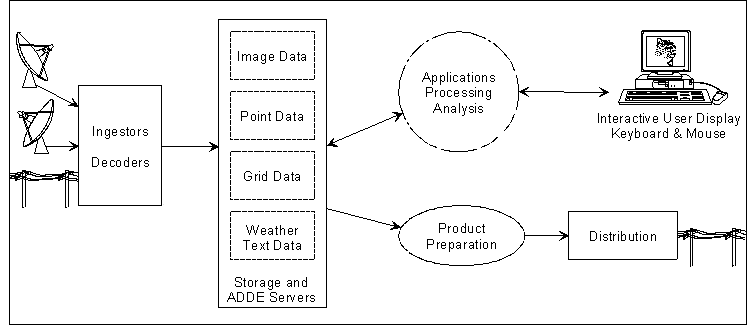
Once the data is converted, users can store, analyze, display and manipulate it using McIDAS-X applications. Figure 2-1 shows how data is received, stored and distributed in McIDAS-X.
Figure
2-1. Ingestors and decoders partition, format, and
file data on machines running ADDE (Abstract Data Distribution Environment)
server software. Then client applications analyze, process, and convert the
data.
A fifth data type, called static data, is also provided with the McIDAS-X software. Each type of McIDAS-X data is described briefly below. More information is presented in following chapters.
McIDAS-X images refer to satellite and radar data. The primary characteristics of image data include:
Gray shading is the most common method of displaying image data.
Satellite images are received from geostationary and polar orbiting satellites. Geostationary satellites remain above a fixed location on the Earth's surface, about 36,000 km above the equator. They are limited in view, approximately 60° either side of the equator. Because geostationary satellites rotate with the Earth, they always view the same portion of the globe. There are usually five geostationary satellites approximately equally spaced, resulting in nearly complete global coverage.
Polar orbiting satellites orbit at much lower elevations, normally 800 to 900 km. Their field of view is about 2,400 km, centered on the orbit path. Unlike geostationary satellites, one polar orbiting satellite generally provides complete coverage of the Earth's surface twice per day.
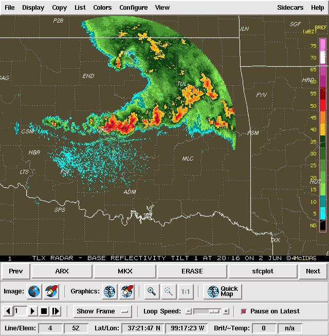
Radars use active sensors that emit short-wave radiation and sample the signals reflected back to the radar antenna. The information represented in radar data is related to the strength of the reflected radar signal and is usually correlated with rainfall intensities. Modern radars also sense the radial component of droplet velocity.
Point observations refer to data reports at specific, irregularly spaced locations. These reports usually contain data for multiple parameters. Most data gathered by direct measurements, such as weather balloons and synoptic reports, is stored as point data.
Point data is listed on the McIDAS-X Text and Command Window in tabular form. If displayed on the Image Window, it is superimposed as a graphic on a frame at the reporting locations.
Grids refer to data placed at regularly spaced intervals at some level in the atmosphere. Grids are displayed graphically using isopleths.
Like images, grids represent data in a two-dimensional, evenly spaced matrix. Unlike images, grids represent data having low volume and high resolution at each data point.
Since grids may represent forecast fields from numerical models, they must have two separate time attributes to identify the data temporally. One time attribute represents the time the model was initialized. The second represents the time the data is valid. For example, a 36-hour forecast from a model run at 00 UTC on 17 January is valid at 12 UTC on 18 January.
Weather text refers to any information transmitted in alphanumeric form. It can be man- or computer-generated output containing forecasts, observations, weather advisories or other public information.
In McIDAS-X, static data refers to database information that changes little over time. Two examples of static data are:
These static data make dissemination of the other McIDAS-X data easier.
The McIDAS-X MAP command uses map files to superimpose outlines of political or geographic boundaries on the McIDAS-X Image Window. These outlines may be associated with data already on the frame or defined in the MAP command itself.
Station tables provide a cross reference list of reporting stations, independent of the reports themselves. For example, if a synoptic observation tells you that the station reporting is number 72641, the report doesn't tell you that 72641 is Madison, Wisconsin. The station tables provide this information.
Users request, receive and display McIDAS-X data using the following:
ADDE makes McIDAS-X image, point, grid and weather text data available to users. During a McIDAS-X session, however, users may need to access other files, such as font files, political and geographic boundary files or station tables, which reside on their workstations but are not available with ADDE. These files can be accessed using file redirection. Additionally, users may want to access files specific to their application that aren't needed by other users. The Unix environment variable MCPATH allows them to do this.
ADDE, file redirection and MCPATH are briefly described on the following pages.
For more information about accessing McIDAS-X data, see the McIDAS User's Guide. |
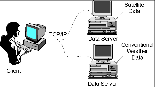
ADDE is a protocol developed for McIDAS that uses a networked system of clients and servers to make weather and other geophysical data available to users. A client is a workstation in a distributed system that initiates a data request, then receives and displays the requested data. A server is the machine in a distributed system that stores data and supplies it to the client upon request. ADDE allows many users to access ingested and decoded data from the same machine, regardless of their location. See Figure 2-2 below.
Figure 2-2. ADDE is a networked system of clients and servers that communicate using the TCP/IP communications protocol.
Each McIDAS-X workstation session acts as both a client and a local server. When a client requests data from the local server, this server searches for the data in the directories that the user's session has access to. A client may also request data from a remote server, which can be one of the following:
Any ADDE command entered by a user to access data must include the ADDE dataset name. The ADDE dataset name consists of two parts:
The group name, which the user configures with the McIDAS-X DATALOC command, is stored in a client routing table. On the client, the group name identifies the server machine to get the data from. On the server, it helps identify the data that the client is requesting.
The server uses the descriptor name to identify the type of data the user wants to access and the range or names of files to search. The table containing this information is called the server mapping table. Users assign dataset names on the server with the DSSERVE command.
When a user enters an ADDE request, the McIDAS-X software performs the steps below to determine the source of the data.
File redirection lets a user identify the location of individual files on the system. The default configuration of a McIDAS-X session is to search for local files in the following directories.
Local files may exist anywhere on the workstation, as long as an application knows where to look for them.
Entries in the file redirection table are made with the McIDAS-X REDIRECT command. For example, a user who has a McIDAS-X application that requires the file MYFILE in the directory /home/fred/data, would enter this REDIRECT command:
REDIRECT ADD MYFILE "/home/fred/data
All subsequent commands that access MYFILE would assume it is in /home/fred/data.
McIDAS-X also contains the environment variable, MCPATH, which defines directories for McIDAS-X commands to search when looking for data and help files. Commands requiring these types of files search each directory in the order listed in MCPATH.
If a user lets McIDAS-X set MCPATH, it will contain the directories shown below. Other directories can be added to MCPATH using the colon (:) character to separate the directory names.
$HOME/mcidas/data:$HOME/mcidas/help:~mcidas/data:~mcidas/help |
If a file exists in more that one directory in MCPATH, McIDAS-X will use the first one that it finds. If you write data to a new file, MCPATH will place that file in the first writable directory in the MCPATH list.
When a user starts a McIDAS-X session, these two windows appear on the screen:
The title bar in each window lists the version of McIDAS-X. In McIDAS-X, it also shows the user's logon and the host name. Optionally, a Graphical User Interface (GUI) can be started, which will become part of the Image Window.
In this section, you will learn how the windows are used and the type of output displayed on them.
The McIDAS-X Text and Command Window is used for:
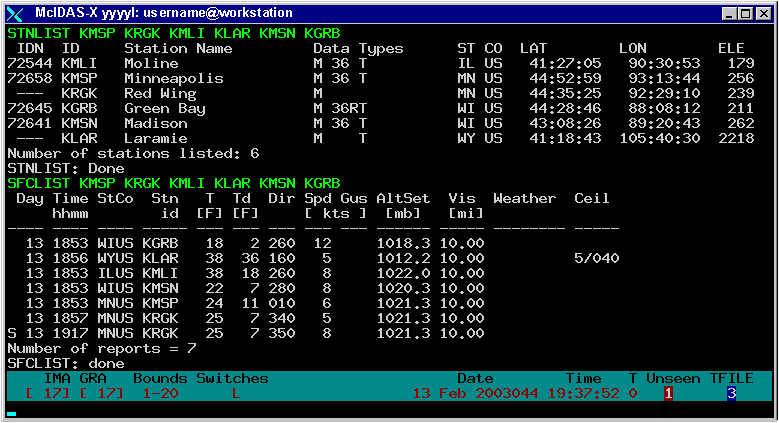
When a session is started, McIDAS-X can display output on 10 different text frames in this window. You can switch between these text frames using the numeric keypad on the keyboard. Figure 2-3 shows a sample McIDAS-X Text and Command Window.
Figure 2-3. The McIDAS-X Text and Command Window displays text messages.
Many system defined single-letter commands toggle the McIDAS-X session between different modes. Others run commands to provide information. These system defined commands are run by simultaneously pressing the Alt key and the letter key, or by typing the letter and pressing Enter from the Text and Command Window.
The table below lists the system defined single-letter commands currently provided in McIDAS-X.
| Command |
Description |
|---|---|
lists Metar, Synoptic and RAOB stations within the cursor bounds |
|
toggles the velocity cursor on and off when tracking cloud drift winds |
|
User defined single-letter commands are run by simultaneously pressing the Ctrl key and the letter key. This causes the contents of the McIDAS-X string corresponding to this letter to be run.
Multiple-letter commands, which are the most common interface for manipulating a McIDAS-X session, have four components:
A sample McIDAS-X command line is shown below.
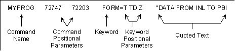
Each command line component and value is separated by one or more blank spaces. An individual parameter requiring a space must be surrounded with single quotes (` ') so it is treated as one parameter.
Command positional parameters provide input to a command and must be entered in the exact order specified. Use them in commands that have options which the user must always enter. One advantage of positional parameters is minimizing the number of keystrokes a user types. Be careful not to negate this advantage by using so many positional parameters that the user can't remember them all.
Like command positional parameters, keywords are used for entering command input. Unlike command positional parameters, they are optional for most McIDAS-X commands and can be entered in any order as long as they follow command positional parameters and precede quoted text.
Keyword parameters are often used to clarify commands with many complicated options. Although keywords can occur in any order, their positional parameters must be entered in the order indicated. Since users don't always specify all keyword positional parameters in a command, be sure to assign them reasonable defaults.
In addition to the keywords that an application has built into it, McIDAS-X has seven global keywords, which are common to all McIDAS-X commands:
You can retrieve the parameters for these global keywords in your applications, as long as you don't change their functionality.
For more information about the McIDAS global keywords, see the McIDAS User's Guide. |
Quoted text input is most often used when a single string entered by a user may require extra spaces. Each application can contain only one quote string and it must be the last part of the command the user enters. Using quote fields in McIDAS commands is relatively easy from the McIDAS Text and Command Window; running McIDAS commands with quote strings from Unix shell prompts is more difficult. For this reason, the preferred method for entering strings with spaces in them from the command line is to use a positional or keyword parameter and surround the string with single quotes.
Text output generated by commands occurs in three different forms.
The default mode for text output is to display standard and error text messages on the Text and Command Window, and to suppress debug messages. Use the DEV global keyword to specify the destination device of the text output generated by a McIDAS command.
Online helps list the syntax of each McIDAS-X command including the parameters, keywords and remarks. To access the online help, type HELP in the McIDAS-X Text and Command Window followed by the command that you want information for. To get the online help for the DSINFO command, for example, you would Type: HELP DSINFO.
Alternatively, you can invoke the HELP command while entering a command from the keyboard by typing the command name, then pressing Alt ?. An abbreviated help is displayed on the current text frame.
The McIDAS-X Image Window displays frames containing McIDAS-X generated images and graphics. Figure 2-4 shows a sample McIDAS-X Image Window. The McIDAS-X Image Window can optionally be surrounded by the McIDAS-X GUI, as shown in Figure 2-5 below.
Figure 2-4. The McIDAS-X Image Window displays images and graphics.
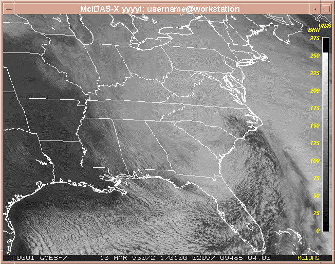
Figure 2-5. The McIDAS-X Image Window can optionally be surrounded by the McIDAS-X GUI.
The manner in which images and graphics are displayed on the Image Window is determined by several factors:
The McIDAS-X Image Window displays satellite and radar data in shades of gray. Alphanumeric data and scientific diagrams are displayed with colored graphical lines and symbols independent of the grayshaded data. Users define the number of gray shades and graphical colors in the .mcidasrc file. The default configuration is 128 gray shades and 16 graphics levels with a maximum of 254 total levels for the image and graphics levels.
When McIDAS-X displays images and graphics on the Image Window, it stores each pixel value in a frame object. The user can map these pixel values to specific red, green and blue color values. The McIDAS-X EU and EB commands modify the color combinations for image data; the GU command modifies the colors of graphics levels.
Via the .mcidasrc file, users can also define the number and size of frames in the McIDAS-X Image Window. The default is to start the session with four frames that are 480 lines (vertical) by 640 elements (horizontal).
McIDAS-X can display an automatically repeating sequence of frames much like a movie loop. The McIDAS-X commands LS and LB define the sequence of frames. The DR command modifies the speed of the loop. The Alt A and Alt B commands step through the individual frames in the loop. Alt L starts and stops the loop.
McIDAS-X uses four different, yet interconnected coordinate systems to define the location of data points within an image:
These coordinate systems are used to reference image data on disk and depict it on the McIDAS-X Image Window. McIDAS-X graphics also use a world coordinate system, which is described in the section titled Advanced McIDAS-X graphics techniques in Chapter 4, McIDAS-X Utilities.
McIDAS-X receives satellite and radar images. The image coordinates for this data are defined by the sensor source providing the image and form the basis for the other McIDAS-X coordinate systems.
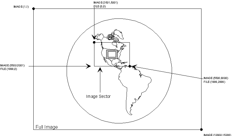
A full image is the entire image transmitted by the sensor. It is a sequence of lines and elements usually arranged from top to bottom, forming a grid for displaying data points on a McIDAS-X frame. Lines run horizontally across the frame; elements run vertically up and down the frame. The top line and leftmost element have the image coordinates (1,1). Each pixel has a unique pair of line and element values that are its image coordinates.
Some sensors have the ability to send only a sector covering a region of interest instead of transmitting a full image. This image sector is a rectangular subset of an image with the same coordinate system. An image sector may also be at a lower resolution, meaning data sampled in lines and/or elements, but the image coordinate system always refers to it relative to a full image. See Figure 2-6 below, which shows a full image and image sector. The upper-left image coordinates of the full image are (1,1); the upper-left coordinates of the image sector are (3501,5001).
In McIDAS-X, images and image sectors are stored in files called areas. File coordinates are based on the physical size of the image sector. They are zero-based and represent the location of a data point in an area file referenced sequentially by lines and elements. In Figure 2-6, the first data point in the image sector has file coordinates (0,0). The bottom-right data point has file coordinates (number of lines minus 1, number of elements minus 1).
Figure 2-6. Image and file coordinates are shown for a full image and image sector.
If the data is navigated, the image coordinates can be converted to earth coordinates (latitude and longitude) and vice versa. Earth coordinates are specified in degrees, minutes, and seconds in the form DDD:MM:SS, or in decimal degrees such as 46.36. In McIDAS-X, all latitudes south of the equator and longitudes east of Greenwich are negative. Latitudes run from -90:00:00 to +90:00:00 and longitudes run from -180:00:00 to +180:00:00.
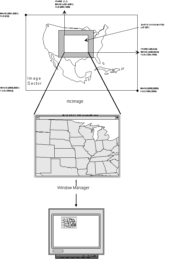
The pixels on McIDAS-X frames are arranged by lines and elements. A frame contains a representation of an image sector displayed on the McIDAS-X Image Window. The image sector shown in Figure 2-7 is an enlarged view of the image sector shown in Figure 2-6. The mcimage program, which is discussed later, takes the image data in the frame and maps it to the McIDAS-X Image Window. The Window Manager then displays the McIDAS-X Image Window on the workstation monitor.
The pixel in the upper-left corner of the frame has the frame coordinates (1,1) which means (line 1, element 1). The total number of lines and elements on the frame is determined by the frame size. The lower-right corner of the default-sized frame is (480,640).
For information about converting coordinate systems from line/element to latitude/longitude and vice versa, see the Image data and McIDAS-X navigation sections in Chapter 5, Accessing Data. |
Frames may be subdivided into rectangular regions called panels. Each panel on an image frame has its own relative coordinate system, which defines the upper-left corner as (1,1). For information about panel generation, and interaction, refer to the McIDAS User's Guide.
Figure 2-7. Earth and frame coordinates are shown for the image sector.
[Search Manual] [Table of Contents] [Go to Previous] [Go to Next]


