SDI-104 Operator's Manual
Version 2007
[Search Manual] [Table of Contents] [FAQ] [Go to Previous] [Go to Next]
The data from MTSAT is broadcast in multiple formats, including High Resolution Imager
Data (HiRID) and High Rate Information Transmission (HRIT). This chapter covers only the HRIT format. The previous chapter covers the HiRID format, also known as the
GMS-5 compatibility mode.
The MTSAT satellite provides one visible image channel and four IR channels.
In the HRIT format, the data rate is 3.5 Mb/second and spatial resolution at the sub-satellite point is 1 km for the visible
channel and 4 km for the IR channels.
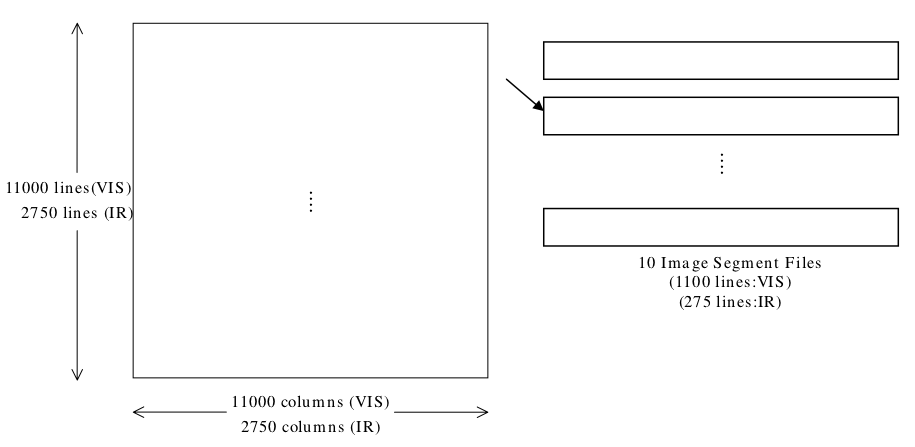
For each channel, the transmitted image data is divided into multiple separate files, called image segment files. Full Earth images consist of ten image segment files per channel, and single hemisphere images consist of five image segment files per channel. A full Earth MTSAT image is 11,000 lines by 11,000 elements for the visible channel, so one complete image consists of ten image segment files, each containing 1,100 lines by 11,000 elements. Similarly, a full Earth MTSAT IR channel image is 2,750 lines by 2,750 elements, so a complete IR image consists of ten image segment files, each 275 lines by 2,750 elements. See Figure 1 for a graphic depicting a full Earth visible or IR image and its ten segment files.
The data contained in an image segment file can be fully determined by the file name alone. The naming convention is:
ffffppppccccYYYYMMDDhhmmnnnn
Where:
ffff
is the file type (IMG_ for image data, OVL_ for map overlay)
pppp
is the projection (DK01 for full disk, DK02 for Northern Hemisphere, DK03 for Southern Hemisphere, SF01 for Small Frame image)
cccc
is the spectral channel (VIS_, IR1_, IR2_, IR3_, or IR4_, which correspond to McIDAS band numbers 1, 2, 3, 4 and 5, respectively)
YYYYMMDD
is the observation date (YYYY=year, MM=month, DD=day)
hhmm
is the observation time (hh=hour, mm=minute)
nnnn
is the image segment file number (_001 to _010)
For example, the file IMG_DK01IR1_200612312332_001 is image segment data file #1 of a full Earth disk image for infrared channel 1, observed at 23:32 UTC on 31 December 2006. Note: If the file type is OVL_, the file name consists of only the file type, the projection, and a three-character spectral channel (e.g., OVL_DK01_VIS or OVL_DK02_IR_).
Figure 1. Full Earth Image and HRIT Segment Files (from JMA HRIT Mission Specific Implementation, Issue 1.2 [pdf])
[Search Manual] [Table of Contents] [FAQ] [Go to Previous] [Go to Next]