McIDAS User's Guide
Version 2014.1
[Search Manual]
[Table of Contents]
[Go
to Previous]
[Go
to Next]
GRDDISP
Generates
contours, streamlines or plots from grid data.
Format
GRDDISP dataset frame [keywords]
Parameters
dataset |
ADDE
dataset name and absolute position; specify one of the following formats: |
|
|
group/descriptor.position
alias.position |
|
only
positive integers or ALL (all positions) are valid for position;
when a grid matching the conditions specified in the search keywords
is found, the search stops (no default for group/descriptor or alias;
default=ALL for position) |
frame |
frame
number to display the output; specify OPP to display the output on the
frame opposite the current frame (default=current) |
Search Keywords
DAY= |
displays
grids with the specified day |
ENSemble= |
e1 . . en |
displays grids with the specified ensemble numbers;
each ensemble number must include a + or - sign,
e.g., -1 -0 +0 +1 |
FDAy= |
displays
grids with the specified forecast day; a grid's forecast day is determined
by adding the forecast hour to the day and time; for example, a 12 UTC
grid from day 95300 with a forecast hour of 72 has a forecast day of
95303; you cannot use FDAY with the FHOUR, FRANGE or MATH keyword |
FHOur= |
h1
. . hn |
displays
grids with the specified forecast hours; use with the keyword GRA to
display the h1 grid in the first frame, h2 grid in
the second frame, etc.; you cannot use FHOUR with the FRANGE, FDAY or
FTIME keyword |
FRANge= |
bhr ehr inc |
displays
grids in the range of forecast hours bhr through ehr, incremented
by inc hours; use with the keyword GRA to display the grids
in forecast hour order (bhr to ehr); you cannot use
FRANGE with the FHOUR, FDAY or FTIME keyword (no default for bhr; ehr default=bhr; inc default=1) |
FTIme= |
displays
grids with the specified forecast time; a grid's forecast time is determined
by adding the forecast hour to the time; for example, a 12 UTC grid with
a forecast hour of 18 has a forecast time of 6 on the following day;
you cannot use FTIME with the FHOUR, FRANGE or MATH keyword |
GPRo= |
displays
grids with the specified projection, for example, MERC, PS, LAMB, EQUI |
GRIB= |
geo par model level
displays
grids with the specified GRIB codes; the four values are the geographic,
parameter, model and level codes that can be listed with GRDLIST
FORM=ALL;
values specified as an X (a placeholder) or not specified at all will
match any GRIB code |
GRId= |
displays
the specified grid or last grid (LAST) in the grid file specified in
the dataset position number; when using this keyword, the default position value
in dataset (ALL) is not valid and all other search keywords
(PARAM, LEV, DAY, etc.) are ignored |
LEV= |
lev[units] |
displays
grids with the specified level and units, e.g., SFC,
850[MB], 5000[M]; units are optional but must be in square brackets
if specified |
PARam= |
param |
displays
grids with the specified grid parameter, for example, T, Z, RH; see the
Remarks |
|
MOVIE |
draws
streamlines with colored line segments that can be animated using the
CM command |
|
STREAML |
draws
streamlines using u- and v-component grids |
|
WINDB |
plots
wind barbs using u- and v-component grids |
|
WINDV |
plots
wind vectors using u- and v-component grids |
SRC= |
s1
. . sn |
displays
grids with the specified sources, for example, MDX, GFS, ETA |
TIMe= |
displays
grids with the specified time |
Multiple Contour/Plot Keywords
GRA= |
bfra efra |
generates
contours or plots for the grids matching the criteria defined with search
keywords in frames bfra through efra; the grids are
displayed by forecast hour in the order specified with the FHOUR keyword
or sequentially from the range bhr to ehr in FRANGE;
you cannot specify both GRA and NUM (bfra default=current; efra default=bfra) |
NUM= |
number
of grids matching the criteria defined with the search keywords to contour
or plot, beginning on the current frame; the grids are not sorted, they
are displayed in the order they are found in the grid files; you must
specify FHOUR or FRANGE with NUM; you cannot specify both NUM and GRA |
Derived Grid Keywords
DERive= |
displays
a derived grid of the specified parameter, for example, DST or VOR; searches
for the component grids using the search keywords; do not use with the
PARAM keyword; see the Remarks |
MERidional= |
YES |
adds
a correction term to account for the convergence of longitude lines at
the poles |
|
NO |
does
not add a correction term; only valid with DERIVE=ABV, DSH, DST, DVG,
or VOR; see the Remarks (default) |
PLAnet= |
planet
for which derive calculations are done; valid options are MERCURY, VENUS,
EARTH, MARS, JUPITER, SATURN, NEPTUNE, URANUS (default=EARTH) |
Mathematical Operations Keywords
Gn= |
'clause1; clause2; .
.; clausen'
grids
to be used with the MATH keyword; separate select clauses with semicolons;
single quotes are mandatory; specify clause using the following
format:
valid
options for searchkeyword are DAY, FHOUR, GPRO, GRID, LEV, PARAM,
SRC, TIME; you can specify numbers between 1 and 99 in the keyword name
(G1, G2, . . , G99); see the Remarks |
MATh= |
'expression' |
mathematical
operation to perform on the grids specified with the Gn keywords;
single quotes are mandatory; see the Remarks |
NEWpar= |
param punit level lunit
title
information for the plot or contour displayed when the MATH keyword is
used |
|
|
param |
grid
parameter; four characters maximum (default=MATH) |
|
|
punit |
units
of grid parameter; four characters maximum (default=NONE) |
|
|
level |
grid
level (default=from grid) |
|
|
lunit |
units
of grid level; two characters maximum (default=from grid) |
Navigation Keywords
LAT= |
lat1 lat2 |
latitudes
of the points at the lower-right and upper-left corners of the map; you
cannot use LAT with the NAV or MAP keyword |
LON= |
lon1 lon2 |
longitudes
of the points at the lower-right and upper-left corners of the map; you
cannot use LON with the NAV or MAP keyword |
MAP= |
map
for the contour or plot; see the MAP command for a list of valid predefined
maps, for example, MID, USA, WORL; you cannot use MAP with the NAV, LAT
or LON keyword (default=grid extents) |
MCOlor= |
graphics
color level of map (default = 1) |
NAV= |
draw
the contour or plot using the navigation of the specified frame; no map
is drawn; you cannot use NAV with the MAP, LAT or LON keyword |
|
num |
frame
number to use for navigation |
|
C |
use
the current frame's navigation |
|
F |
use
the navigation of the frame where the contour or plot is drawn |
PRO= |
CONF |
polar
stereographic or Lambert conformal projection |
|
MERC |
Mercator
projection (default=grid's projection) |
SLAt= |
lat1 lat2 |
standard
latitudes for a CONF projection; two values for a general Lambert conformal
projection; one value for a polar stereographic projection (default=from
grid header when the LAT and LON, or MAP keywords are not used; 60 60
for northern hemisphere maps defined with the LAT and LON, or MAP keywords;
-60 -60 for southern hemisphere maps defined with the LAT and LON, or
MAP keywords) |
SLOn= |
standard
longitude for a CONF projection (default=computed) |
Contour and Plot Keywords
COLor= |
graphics
color level (default=2 for contour, 3 for plot); when plotting data (with
OUT=PLOT or PAR=WINDB or PAR=WINDV), the value can be specified as a
single number, e.g., COLOR=5, or in the format color[min-maxBinc]
to assign multiple colors for the parameter, based on its values; see
the Remarks for details |
ELE= |
bele eele |
beginning
and ending frame elements for output; specify MAX for maximum element
number (default=1 MAX when using the NAV keyword; default=20 MAX-20 when
using the MAP keyword) |
FORMAT= |
designator 'text'
output
format for grid point values or contour labels, and associated text;
valid formats are I, F, or E; if multiple parameters are requested, FORMAT
cannot be specified; see the Remarks (designator default=from dataset;
no text default) |
LINE= |
blin elin |
beginning
and ending frame lines for output; specify MAX for maximum line number
(default=1 MAX-57 when using the NAV keyword; default=20 MAX-57 when
using the MAP keyword) |
LSIze= |
height, in pixels, of the plot characters or contour labels; the range is 0-50 where 0 omits the labels (default=8) |
OUT= |
CON |
draws
contours using the grid data (default) |
|
PLOT |
plots
the grid points |
POWer= |
power
of 10 to multiply the grid point values by for display (default=0) |
TDAy= |
CAL |
display
calendar day on the default title; not valid if the ELE, LINE or PAN
keyword is used |
|
JUL |
display
the Julian day on the default title (default) |
TITLE= |
'text' col line ele size
text,
color, location and size for the contour or plot title |
|
|
'text' |
72
characters maximum; specify X without quotes for the default title (default=computed) |
|
|
col |
graphics
color level of the title (default=1 if PARAM=MOVIE, otherwise default=value
from the COLOR keyword) |
|
|
line |
beginning
TV line to write the title (default=below contour or plot) |
|
|
ele |
beginning
TV element to write the title (default=below contour or plot) |
|
|
size |
height
of the title text in pixels (default=8) |
UNIt= |
units
for the contour or plot; see the Remarks (default=from the grid header) |
Contour-Specific Keywords
CINt= |
num |
contour
interval; specify 0 to let GRDDISP compute a reasonable interval; specify
your own interval as an integer or decimal value greater than zero; see
the Remarks for the default value |
|
string |
contour
values; specify a string name that contains up to 64 values; e.g., CINT=SNOWDEPTH
will draw contours at the values specified in the string named SNOWDEPTH |
DASh= |
ALL |
dash
all contours |
|
NEG |
dash
negative contours only |
|
POS |
dash
positive contours only |
|
(default=solid
contours) |
LINT= |
contour
label interval (default=1, meaning label every contour) |
MOVie= |
bcol ecol bspd espd blen elen
change
the defaults for the PARAM=MOVIE output |
|
|
bcol |
beginning
graphics color level for line segments (default=2) |
|
|
ecol |
ending
graphics color level for line segments (default=maximum color level) |
|
|
bspd |
beginning
wind speed represented by blen, units are from the grid data
(default=computed) |
|
|
espd |
ending
wind speed represented by elen, units are from the grid data
(default=computed) |
|
|
blen |
beginning
length of line segments (default=2) |
|
|
elen |
ending
length of line segments (default=40) |
SMOoth= |
contour
smoothing factor; the range is 0 through 50; larger numbers produce smoother
contours; not valid with PARAM=MOVIE or PARAM=STREAML (default=20) |
Plot-Specific Keyword
PINt= |
row col |
row
and column intervals of grid points to plot with OUT=PLOT, PARAM=WINDB
or PARAM=WINDV; for example, PINT=4 3 plots every fourth grid point in
the row direction and every third grid point in the column direction
(row default=1; col default=row) |
Output Keywords
BYTecount= |
YES |
lists
the number of bytes received from the server |
|
NO |
does
not list the number of bytes (default) |
SUBsect= |
slat nlat elon wlon incrow inccol
geographic
region to subsect from the source grid, and row and column reduction
intervals to use within the subsect region; see the Remarks |
|
slat, nlat |
southern
and northern latitudes of the subsect region |
|
elon, wlon |
eastern
and western longitudes of the subsect region (slat, nlat, elon, wlon defaults=region
slightly larger than that defined by the frame navigation or map specified
with MAP or LAT and LON keywords; if NAV=F is specified, the grid is
not subsected) |
|
incrow, inccol |
row
and column reduction intervals; 1 means use every row/column of grid
points in the subsect region, 2 means use every other row/column, etc.;
when subsecting a conformal projection grid, the incrow and inccol values
must be the same (default=1 for both) |
|
Note:
If the source grid is a McIDAS grid, you can subsect it by row and column
instead of latitude and longitude. To do so, specify row and column numbers
instead of latitudes and longitudes in the first four parameters, and
specify ROWCOL as the seventh parameter. For example, SUBSECT=10 40 80
160 1 2 ROWCOL uses rows 10, 11, 12, ..., 40 and columns 80, 82, 84,
..., 160 for the subsect region. (If you don't include the ROWCOL at
the end, it will treat 10 and 40 as latitudes, and 80 and 160 as longitudes.) |
Remarks
Individual
grids are stored in grid files. Each dataset position points to a single grid
file. If you know which grid file contains the grid you want to display, specify
its position in the dataset parameter to reduce the searching time.
The GRDDISP
command draws contours or streamlines, or plots data from the first grid or
set of grids that matches the conditions specified with the search keywords.
If you don't specify any search keywords, GRDDISP displays the first grid in
the dataset. If, for example, you specify PARAM=T LEV=850 TIME=12 SRC=ETA,
GRIDDISP displays the first grid with T in its parameter field, 850 in its
level field, 12 in its time field, and ETA in its source field. To choose the
exact grid you want, you may need to specify several search keywords.
Use the keyword
FHOUR or FRANGE with GRA or NUM to generate a contour or plot using more than
one grid with a single GRDDISP command. The keyword GRA displays the grids
in the order entered with FHOUR or sequentially from the range bhr to ehr in
FRANGE. For example, if you specify SRC=GFS TIME=12 PARAM=Z LEV=500 FHOUR=0
36 24 60 GRA=11 14, the 12 UTC GFS 500 mb height grids with forecast hours
0, 36, 24 and 60 are displayed in frames 11, 12, 13 and 14.
The default
contour interval for a grid is taken from the text file CONTOUR.DEF.
If no file entry matches the grid's parameter, units and level, the default
is calculated to produce a reasonable number of contours, usually between 10
and 20. To change, add or delete entries in CONTOUR.DEF,
first back up the current version, then modify it using the format described
near the top of the file.
If you specify
PARAM=MOVIE, STREAML, WINDB or WINDV, GRDDISP does not search for a grid with
that parameter. Instead, it locates the first u-component grid that matches
the other search keywords, then it locates the matching v-component grid and
uses those grids to contour streamlines, plot wind barbs, or plot wind vectors.
In all other cases, the value entered in the keyword PARAM is the value searched
for in the grid's parameter field.
When plotting data (with OUT=PLOT or PAR=WINDB or PAR=WINDV),
you can assign output plot color based on the parameter's values by using the
COLOR keyword format color[min-maxBinc],
where color is the beginning graphics color level, min and max indicate
the range of parameter values to color-code, and inc is the increment
(the dash means "to" and the B means "by"). For example, when plotting integer
values, COLOR=2[30-59B10] plots values 30-39 in level 2, values 40-49 in level
3, and values 50-59 in level 4. Values less than 30 are in level 1, and values
greater than 59 are in level 5. When plotting floating point values (e.g.,
FORMAT=F5.2), COLOR=2[30-59.99B10] plots values 30.00-39.99 in level 2, values
40.00-49.99 in level 3, and values 50.00-59.99 in level 4. Values less than
30.00 are in level 1, and values greater than 59.99 are in level 5. Also, when
plotting color-coded wind barbs (PAR=WINDB), the units of the 'min' and 'max'
values are knots, even if you specify UNIT=MPS.
Use the SUBSECT
keyword to analyze a portion of the original grid. The analysis can be performed
slightly faster because there is less data to transfer and analyze.
Wind barb
symbols use triangular flags, and long and short lines, or barbs, to represent
wind speed. For example, the wind barb shown here represents a wind speed of
75 knots or 37.5 meters/second.

- a flag represents
50 knots or 25 meters/second
- a long barb
represents 10 knots or 5 meters/second
- a short
barb represents 5 knots or 2.5 meters/second.
When using
the UNIT keyword, you can specify the following units:
| Unit
type |
UNIT= |
Definition |
| Distance |
CM |
centimeters |
| DM |
decameters |
| FT |
feet |
| GPM |
geopotential
meters |
| IN |
inches |
| KM |
kilometers |
| M |
meters |
| MI |
miles |
| MM |
millimeters |
| NMI |
nautical
miles |
| YD |
yards |
| Pressure |
HPA |
hectopascals |
| INHG |
inches
of mercury |
| MB |
millibars |
| Speed |
KT
or KTS |
knots |
| MPH |
miles
per hour |
| MPS |
meters
per second |
| Temperature |
C |
Celsius |
| F |
Fahrenheit |
| K |
Kelvin |
Use the DERIVE
keyword to display grids of a variety of common meteorological parameters.
The valid options are defined in the table below. In these equations, the following
variables appear often:
u =
u-component of the wind
v =
v-component of the wind
x =
grid point distance in the east-west direction
y =
grid point distance in the north-south direction
| DERIVE= |
Description |
Equation |
| ABV |
absolute
vorticity |

f =coriolis
parameter: 2ΩsinΦ (see
COR) |
| BETA |
beta
parameter |

f =coriolis
parameter: 2ΩsinΦ (see
COR)
Ω=angular
speed of the rotation of the planet (7.292 × 10⁻⁵ radians/second
for Earth)
Φ=latitude
in degrees
a=radius
of the planet |
| COR |
coriolis
parameter |
2ΩsinΦ
Ω=angular
speed of the rotation of the planet (7.292 × 10⁻⁵ radians/second for Earth)
Φ=latitude
in degrees |
| DIR |
wind
direction |
atan2(-u,-v) |
| DSH |
shearing
deformation |
 |
| DST |
stretching
deformation |
 |
| DVG |
divergence |
 |
| SPD |
wind
speed |
 |
| TD |
dew
point temperature |
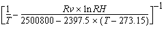
T =temperature
in Kelvin
RH =relative
humidity
Rv=moist
gas constant: 461.5 Joules per kilogram per degree Kelvin |
| VOR |
relative
vorticity |
 |
Use the MERIDIONAL
keyword to correct for the convergence of longitude lines at the poles. When
deriving divergence and stretching deformation grids (DVG and DST), specify
MERIDIONAL=YES to subtract the following correction term from the calculation.

When deriving
vorticity, absolute vorticity, or shear deformation grids (VOR, ABV, or DSH),
specify MERIDIONAL=YES to add the following correction term to the calculation.

For both
the correction terms above:
u =
u-component of the wind
v =
v-component of the wind
Φ =
latitude in degrees
r =
radius, in kilometers, of the planet at Φ latitude
The MERIDIONAL
keyword has no effect with other DERIVE keyword options.
Use the Gn keywords
to specify the grids to be used with the MATH keyword. Each Gn keyword
specifies a single grid. Gn is followed by a list of select clauses
in single quotes. By default, subsequent Gn keywords have the same
select clauses, unless specified differently. For example, to request 850 and
1000 mb height grids from the 0:00 UTC GFS run, specify
G1='LEV 850;PARAM Z;TIME 0;SRC GFS' G2='LEV 1000'
The MATH
keyword defines the operation to perform on the specified grids, for example,
MATH='G1**(SQRT(G2))'. The table below shows the operations available with
the MATH keyword.
| MATH= option |
Function |
| + |
addition |
| - |
subtraction |
| * |
multiplication |
| / |
division |
| ** |
power |
| SQRT |
square
root |
| EXP |
exponential
(the number e raised to a power) |
| LOG |
natural
logarithm |
| LOG10 |
base
10 logarithm |
| SIN |
sine |
| COS |
cosine |
| TAN |
tangent |
| ASIN |
arcsine |
| ACOS |
arccosine |
| ATAN |
arctangent |
| ABS |
absolute
value |
| MIN |
minimum
of two grids |
| MAX |
maximum
of two grids |
| DDX |
derivative
with respect to x |
| DDY |
derivative
with respect to y |
| DELSQ |
laplacian |
| COR |
coriolis
parameter (2ΩsinΦ) |
| BETA |
beta
parameter  |
| LAT |
creates
a grid of latitude |
| LON |
creates
a grid of longitude |
When specifying
powers of ten, such as 102 or 10-3 in the MATH keyword, use one of the two
methods shown in the examples below.
MATH='2*7.292*(1e-5)*(SIN(G1))'
MATH='2*7.292*(10**(-5))*(SIN(G1))'
In these
entries both 1e-5 and 10**(-5) represent 10-5. You must include the parentheses
with 10**(-5); 10**-5 will not be interpreted correctly.
When using
the MATH keyword and the range of output data values is larger than five orders
of magnitude, the output grid is scaled based on the maximum end of the range.
This means that small data values may be replaced by zeros in the output grid.
Use the FORMAT
keyword options below to format output based on FORTRAN designators for data
output. To add text to the numeric output, follow the designator with a text
in single quotes.
| Designator |
Description |
| I |
integer |
| F |
floating
point |
| E |
exponential |
To specify
a parameter's output format, use a designator followed by a positive number.
For example, I4 specifies an integer of up to four digits; F10.1 specifies
a floating point decimal of up to 10 digits (including the decimal point) with
one digit to the right of the decimal; E10.3 specifies an exponential number
of up to 10 characters (including the decimal point and the four-character
exponential flag) with three digits to the right of the decimal. Specify an
X to use the parameter's default format. If the specified integer or floating
point format is too small for the parameter's values, a series of asterisks
(***) is displayed.
Examples
GRDDISP G/LOCAL
This entry
draws a contour using the first grid in the first grid file in dataset G/LOCAL.
The map and contours cover the grid's entire domain. The contour interval is
taken from the text file CONTOUR.DEF if
it has an entry that matches the grid's parameter, units and level. If CONTOUR.DEF does
not have a matching entry, GRDDISP calculates the contour interval.
GRDDISP G/LOCAL.9 GRID=5 OUT=PLOT PINT=1 3 NAV=C
This entry
plots grid point values from grid 5 in the grid file in position 9 of dataset
G/LOCAL. Every grid point in the row direction and every third grid point in
the column direction is plotted using the navigation of the current frame.
GRDDISP NMC/ETA LEV=1000 PARAM=WINDV DAY=#Y TIME=0 FDAY=#Y FTIME=18
MAP=MID PRO=MERC TITLE='ETA 1000 mb wind vectors, valid at 18 UTC today'
This entry
plots the 1000 mb wind vector forecast valid at 18 UTC today over the Midwest.
The vectors are created using the u- and v-component grids from today's 00
UTC model run in dataset NMC/ETA. The default title below the plot is replaced
with the text ETA 1000 mb wind vectors, valid at 18 UTC today.
GRDDISP NCEP/GFS LEV=500 PARAM=Z CINT=60 FHOUR=24 LAT=-40 -40 LON=-90
90 SLAT=-40 PRO=CONF
This entry
draws a contour of the 24-hour forecast 500 mb heights with an interval of
60 over the South Pole. The data is taken from the first 24-hour forecast 500
mb height grid in dataset NCEP/GFS.
GRDDISP NCEP/GFS LEV=500 PARAM=Z CINT=60 DAY=#Y TIME=12 FRANGE=0 120
24 GRA=1 6
This entry
draws a contour of the 0-, 24-, 48-, 72-, 96- and 120-hour forecast 500 mb
heights with an interval of 60. The contours are displayed over a map of the
grids' domain in frames 1, 2, 3, 4, 5 and 6. The data is taken from today's
12 UTC model run grids in dataset NCEP/GFS.
GRDDISP MODEL.2 LEV=850 PARAM=T UNIT=C CINT=5 SRC=GFS DASH=NEG COLOR=5
This entry
draws a contour of the first 850 mb GFS temperature grid in the grid file in
position 2 of the dataset with the alias name MODEL. The map and contours cover
the grid's entire domain. The contours are drawn in graphics color level 5
with an interval of 5 degrees Celsius. Negative contours are dashed.
TE SNOW "0 10 20 32 40 60
GRDDISP NMC/ETA LEV=850 PARAM=T UNIT=F CINT=SNOW MAP=USA PRO=CONF
The TE command
entry creates a string called SNOW containing contour values for the GRDDISP
entry. The GRDDISP entry draws a contour of the first 850 mb temperature grid
in dataset NMC/ETA. The map and contours cover the USA, and only the 0, 10,
20, 32, 40 and 60 degree Fahrenheit contours are drawn. Do not specify a pound
sign (#) before the string name in the CINT keyword.
GRDDISP GRIDS/GFS LEVEL=SFC PARAM=T DAY=97300 FHOUR=24 MAP=USA SUBSECT=25
50 60 100
This entry
draws 24-hour forecast surface temperature contours from the dataset GRIDS/GFS.
A map of the United States is drawn, but the contours are drawn only for the
geographic region specified in the SUBSECT keyword (25-50°N and 60-100°W).
If the SUBSECT keyword was not specified, GRDDISP would subsect a region slightly
larger than the map and draws contours in the entire frame.
GRDDISP GRD.8000 4 LAT=20 50 LON=75 145 PRO=CONF DERIVE=SPD LEV=500
FHOUR=48
This entry
draws a 500 mb wind speed contour with a 48-hour forecast time. The component
grids used to derive wind speed are the u- and v-components of the wind from
position 8000 in the dataset with the alias GRD. The contour is displayed on
frame 4 over a polar stereographic map between 20° and 50° latitude
and 75° and 145° longitude.
GRDDISP RTGRIDS/GFS MAP=USA PRO=MERC DERIVE=VOR LEV=500 DAY=96284
TIME=12 FHOUR=12 24 36 48 GRA=1 4 DASH=NEG
This entry
draws contours for a sequence of 500 mb relative vorticity grids from day 96284
at 12:00 UTC. The component grids are from dataset RTGRIDS/GFS. The 12-, 24-,
36-, and 48-hour forecast contours are displayed on frames 1, 2, 3, and 4,
and displayed over the USA in a Mercator projection. All negative contours
are dashed.
GRDDISP RTGRIDS/GFS PARAM=MOVIE LEV=500 DAY=#Y TIME=0 FHOUR=18 MAP=USA
MOVIE=2 8
TE MOVIECOLORS "GU MAKE !1 0 !2 0
REPEAT MOVIECOLORS 2 TO 8 BY 1 0 BY 40
CM 2 8 GO=YES
The GRDDISP
entry draws the 18-hour GFS forecast 500 mb streamlines with colored line segments
on a map of the U.S. The TE and REPEAT entries set graphics color levels 2
to 8 to increase linearly from black (level 2) to bright green (level 8). The
CM entry then circulates the graphics color levels to animate the wind flow.
GRDDISP RTGRIDS/NAM-USLC DAY=#Y TIME=12 FHOUR=12 PAR=T LEV=SFC UNIT=F
MAP=USA COLOR=3[10-69B10] OUT=PLOT FORMAT=I4 PINT=2 3
This entry plots the 12-hour forecast surface temperatures
over the United States from today's 12 UTC NAM model run. The temperatures
are color coded: less than 10°F in graphics color level 2, 10-19°F
in level 3, 20-29°F in level 4, 30-39°F in level 5, 40-49°F in
level 6, 50-59°F in level 7, 60-69°F in level 8, and 70°F and greater
in level 9.
GRDDISP RTGRIDS/GFS-GLME DAY=#Y TIME=0 FHOUR=24 PAR=WINDB LEV=700
UNIT=KTS MAP=NA COLOR=2[1-20B5] PINT=3 3
This entry plots the 24-hour forecast 700 mb wind barbs
over North America from today's 00 UTC GFS model run. The flags are color coded
by speed: less than 1 knot in graphics color level 1, 1-5 knots in level 2,
6-10 knots in level 3, 11-15 knots in level 4, 16-20 knots in level 5, and
greater than 20 knots in level 6. Note that each flag symbol may appear in
two different colors because the speeds are rounded to the closest five knot
increment (i.e., 2.5-7.4 knot speeds are displayed as 5 knot flags, 7.5-12.4
knot speeds are displayed as 10 knot flags, 12.5-17.4 knot speeds are displayed
as 15 knot flags, etc.). Thus, 5 knot flags can be in graphics color level
2 or 3, 10 knot flags can be in level 3 or 4, 15 knot flags can be in level
4 or 5, etc.
[Search Manual]
[Table of Contents]
[Go
to Previous]
[Go
to Next]