McIDAS-X User's Guide
Version 2021.1
[Search Manual]
[Table of Contents]
[Go to Previous]
[Go to Next]
IMGPLOT
Displays a scatter plot of data values from two images.
Format
IMGPLOT ximage yimage [keywords]
Parameters
|
ximage
|
image to use for x-axis of plot; specify a frame number or an ADDE dataset name and position (default=current frame)
|
|
yimage
|
image to use for y-axis of plot; specify a frame number or an ADDE dataset name and position (default=frame opposite ximage)
|
Keywords
|
BANd=
|
xband yband
|
image band numbers to plot (default=displayed band or default band from dataset image)
|
|
COLor=
|
graphics color level of the plot (default=3)
|
|
FIT=
|
order color
|
draws a curve fit of the data, where order is the polynomial order (0-7) and color is the graphics color level (order default=0, meaning do not draw a curve fit; color default=5)
|
|
GRA=
|
graphics frame to display the scatter plot (default=current)
|
|
ID=
|
xid yid
|
NEXRAD station IDs (e.g., MKX and ARX) of the desired images in the datasets specified in ximage and yimage; this keyword is needed only with NEXRAD datasets
|
|
LATlon=
|
lat lon
|
center latitude and longitude of the image region to plot; not valid with the STATION keyword (default=location of cursor on frame)
|
|
LSTAT=
|
YES
|
includes statistics for the image region (default)
|
|
|
NO
|
does not include statistics
|
|
SIZE=
|
line ele
|
number of lines and elements defining the image region to plot (default=cursor size)
|
|
STAtion=
|
station ID at the center of the image region to plot; specify as the ID, e.g., KMSN or YSSY, optionally followed by the station type in brackets, e.g., ARX[N] or ARX[V]; see the TYPE keyword in the STNLIST command for valid station types; this keyword is not valid with the LATLON keyword
|
TRACKing= |
YES |
tracks image if allowed by the server; tracking allows commands
to receive data as it's being ingested by the server; commands complete when their data request has been fulfilled; tracking
is only supported on some servers (e.g., Area, GVAR and MTSAT) and it can be disabled by the server administrator |
|
NO |
does not track image so server only sends data that is
currently available (default=value of MCTRACK environment variable; if MCTRACK is not set, default=value set by server
or server administrator) |
|
UNIt=
|
xunit yunit
|
calibration units to plot, for example, RAW, RAD, TEMP, BRIT, ALB; list the valid units for an image using the IMGPROBE command (default=BRIT xunit)
|
|
XDIv=
|
major minor
|
number of major and minor divisions for the x-axis (default=10 4)
|
|
XRAnge=
|
min max
|
range of data values for the x-axis of the plot (default=calculated)
|
|
YDIv=
|
major minor
|
number of major and minor divisions for the y-axis (default=10 4)
|
|
YRAnge=
|
min max
|
range of data values for the y-axis of the plot (default=calculated)
|
Remarks
IMGPLOT displays a scatter plot of data values from two images. Specify the images in ximage and yimage with frame numbers or with ADDE dataset names and positions. If you specify frame numbers, you must display the images using the IMGDISP command, and the image files must be present on disk (as opposed to workstation memory).
The location and size of the image region to be plotted are determined by the STATION or LATLON, and SIZE keywords. If you do not specify STATION or LATLON, you must select the region to be plotted. Move the cursor to the desired location on one of the frames and click the right mouse button or press Alt G.
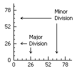
The XDIV and YDIV keywords define the number of major and minor divisions in the plot. Minor defines the number of subdivisions for each major segment. Labels are placed at each major division. See the diagram below.
Examples
IMGPLOT
This entry draws a scatter plot of brightness data in the images displayed in the current and opposite frames. The scatter plot is drawn on the current frame in graphics color level 3 and uses the brightness data inside the cursor.
IMGPLOT 1 2 STATION=KSLC SIZE=480 640 UNIT=TEMP GRA=3
This entry draws a scatter plot of temperature data in the images displayed in frames 1 and 2. The scatter plot is drawn on frame 3 and uses the temperature data inside a 480 by 640 pixel region centered at Salt Lake City.
IMGPLOT 10 10 LATLON=35 90 BAND=4 4 UNIT=BRIT TEMP XRANGE=120 220 GRA=11
This entry draws a scatter plot of band 4 brightness and temperature data in the image displayed in frame 10. The scatter plot is drawn on frame 11 and uses the brightness and temperature data inside the cursor. The plot's x-axis ranges from 120 to 220 brightness levels.
IMGPLOT EAST/FDIR.1 EAST/FDV.1 BAND=3 1 STATION=KMIA SIZE=100 100
This entry draws a scatter plot of band 3 brightness data in the image EAST/FDIR.1, and band 1 brightness data in the image EAST/FDV.1. The scatter plot is drawn on the current frame and uses the brightness data inside a 100 by 100 pixel region centered at Miami.
[Search Manual]
[Table of Contents]
[Go to Previous]
[Go to Next]