McIDAS-XCD Administrator's Guide
Version 2018.2
[Search Manual] [Table of Contents] [Go to Previous] [Go to Next]
Lists the number of real-time grids received for a specified day.
NMCAMT lists both complete and partial real-time grids. A partial grid contains incomplete grid sections. Currently, the GFS model is the only model transmitted in pieces; thus, it is the only model containing partial grids.
Note: The NGM options are still valid in this command even though the NWS terminated the NGM model and its associated products beginning 03 March 2009 (NWS TIN08-90).
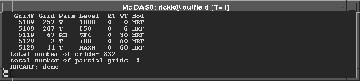
The FORM=STD option provides the following information:
The screen below shows an example of the FORM=STD output.
The projection of an GFS grid determines how it is sent. Grids that are 145 rows by 289 columns are sent in the following eight sectors:
Grids that are 73 rows by 73 columns are sent in the following four sectors:
If a grid is missing a section, the FORM=ALL option marks the missing section with an asterisk (*). In the example below, grid 257 in grid file 5109 is missing the fourth section. The Xs indicate that sectors 1-3 and 5-8 were received.
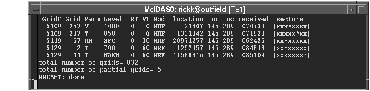
The FORM=ALL option provides the following additional information:
This entry lists all the real-time grids that are missing grid sections and the total number of grids received for the current day.
NMCAMT MOD=GFS FORM=ALL TIME=0
This entry lists, in expanded form, all the 0 UTC model run GFS grids.
[Search Manual] [Table of Contents] [Go to Previous] [Go to Next]