GOES-16: First light in true color

GOES-16 Advanced Baseline Imager sent back its first high-res, true color images of Earth in mid-January 2017. Credit: NOAA, NASA
After spending months in space, quietly orbiting the Earth, the next generation of geosynchronous satellite has broken its silence and sent back its first images to Earth. With a suite of onboard instruments, GOES-16 delivers rapid, high-resolution imagery of the Earth’s atmosphere, giving researchers and a host of users an unprecedented look for weather forecast applications.
On January 23, 2017, the National Oceanic and Atmospheric Administration released the GOES-16 “first light” images of Earth in high resolution. The University of Wisconsin-Madison (UW-Madison) Space Science and Engineering Center (SSEC) and Cooperative Institute for Meteorological Satellite Studies (CIMSS), and other partners, have been working with NOAA from day one to make GOES-16 a reality. Taken from more than 22,000 miles away, GOES-16 offers striking imagery of the planet and its weather.
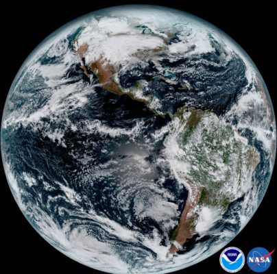
The first “full disk” image from GOES-16, taken early 2017. Credit: NOAA, NASA
For more than 40 years, Geostationary Operational Environmental Satellites (GOES) have been serving a critical role in monitoring weather systems over the United States. And for just as long – even longer – SSEC and CIMSS at UW-Madison have been proposing, testing, and evaluating each generation of satellite instruments and sensors, as well as analyzing their data.Compared to current GOES satellites in orbit, the ABI’s assortment of lenses and mirrors and detectors gives it three times more spectral bands, four times greater spatial resolution, and can capture data five times faster, sending images of Earth as often as every 30 seconds (for mesoscale observations). These upgrades will augment the tools used by researchers and forecasters to improve weather predictions and increase warning times.
A true color comeback
A familiar yet often overlooked channel, visible light, has made its comeback as part of GOES-16’s Earth-focused instrument, the Advanced Baseline Imager (ABI). Visible light comprises the range of wavelengths that can be seen with the naked eye. A true color image of Earth, which uses that visible light, depicts features like blue oceans, white clouds, and green vegetation, similar to a film camera.
“It’s great to see true color come back into the mix,” says Tim Schmit, NOAA satellite research scientist working with researchers at the UW-Madison CIMSS. “Not only does it help round out the toolkit available on the ABI, but the true color images have long had an impact on how we see our Earth and its weather,” adds Schmit.

A true color image of 2016 Hurricane Matthew making landfall over the U.S. eastern coast. True color imagers have historically been a part of many polar-orbiting satellites, unlike their geostationary cousins. Image credit: SSEC
The majority of the ABI’s channels are in the infrared (IR) spectral region, plus four bands in the near-IR spectral region. With 16 channels in total, the ABI rounds out its array with two channels in the visible light range, both blue and red. A near-infrared detector known as the “vegetation band” serves as the ABI’s green color substitute and is able to detect areas of vegetation based on how much light is reflected.
Combine all three channels and the result is a natural color image, full of details—snow capped mountains, flooded rivers, Atlantic storms, fog, and clear skies. Infrared, on the other hand, requires digital translation to convert their data into something eye-catching. The resulting visualizations, however, deliver a wealth of information about clouds, their altitudes, and the conditions that formed them.

Earth, as seen though visible light, has long captured imaginations throughout history. From top-left clockwise: Earth Rise taken by Apollo 8 astronauts on the Moon (1968), The Blue Marble taken by Apollo 17 astronauts in low-Earth orbit (1972), the first true color full-disk image of Earth taken by ATS-III geosynchronous satellite (1967), The 2012 Blue Marble taken by polar orbiting satellite Suomi NPP. Image credits: NASA, NOAA, SSEC
“From a data standpoint, each band has its strengths and limitations,” says Schmit. “Visible light offers us the qualitative information we need, while infrared gives the quantitative details, all of which are needed to understand something as complex as our atmosphere.”
Over the next 15 years, GOES-16 will transmit droves of data back to Earth, where receivers atop the SSEC building pick up incoming signals and start the computationally intense process, transforming them into useful information and imagery. Staff at SSEC and CIMSS, working with NOAA scientists, will translate the satellite’s signals into products that can be used to improve forecasts and monitor various phenomena.
On average, GOES-16 sends 100s of GBs of data per day and is stored on SSEC’s Data Center servers. Once compiled, the digital mosaics give scientists the ability to compare and contrast imagery and analyze the details locked away in each pixel.
Looking back
Imagery from weather satellites has come a long way since the world’s first geostationary satellite, ATS-I, launched in 1966. This satellite carried a single camera, centralized in the “green” part of the visible electromagnetic spectrum. Through this monochromatic lens, ATS-I was able to capture the first full-disk images of Earth. They were later compiled into motion pictures showing the movements of clouds over the Pacific Ocean. The following year, ATS-III launched and sent back its view of the Earth, this time in true color using a full array of red, green, and blue channels (see the video below).
“Interestingly, the early days of geo satellites started with true color,” says Schmit. “Until now, 1967 was the heyday of true color from geostationary orbit, but with Japan’s AHI leading the way, and now on the ABI, even better data will be available.”
Over the years, multiple visible spectral channels, unlike their infrared counterpart, have not been featured as part of most geostationary weather satellite missions. Schmit attributes this in part to a key limitation of visible light channels—since the visible channels are sensitive to reflected sunlight, they are dark at night. Other IR frequencies can deliver consistent data regardless of the Earth’s position relative to the Sun.
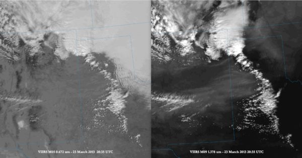
An image taken over Texas and surrounding states using visible light (left) and near-infrared (right). The visible light shows cloud formations, while the near-IR reveals interesting details of a dust storm occurring over New Mexico and Texas. Image credit: SSEC, CIMSS
In mid-2015, Japan launched its Himawari-8 geostationary satellite where it settled into orbit over the equator near Papua New Guinea, observing weather developments over the Pacific Ocean, Southeast Asia, and many equatorial countries. Its AHI imager was the first in more than 50 years to feature a full-spectrum visible light array aboard a geostationary satellite that measures red, green, and blue wavelengths, along with a similar near-IR vegetation band like GOES-16.
“A true color image will always have a place in the toolbox,” says Schmit. “It’s always been intuitive, because once you look at the picture, you know what you’re seeing.”
For more information, see: Miller, S.D., Schmit, T.L., Seaman, C.J., et al, 2016: A sight for sore eyes: The return of true color to geostationary satellites. Bulletin of the American Meteorological Society 97 (10), 1803-1816, DOI: http://dx.doi.org/10.1175/BAMS-D-15-00154.1
by Eric Verbeten