8.2. Executing the MODIS Polar2Grid Test Case
To run the MODIS GeoTIFF test case, unpack the test data as shown in Section 2.2 and execute the following commands:
cd polar2grid_test/modis
mkdir work
cd work
polar2grid.sh -r modis -w geotiff -p true_color false_color --fill-value 0 \
  --grid-configs ${POLAR2GRID_HOME}/grid_configs/grid_example.yaml -g miami -f ../input/
The test case consists of a set of MODIS archived 5 minute HDF 4 Level 1B granule files (1KM, HKM, QKM and Geolocation) for a Terra MODIS pass observed on 19 March 2017 at 16:30 UTC. In this test, the Polar2Grid software is using the example configuration file (${POLAR2GRID_HOME}/grid_configs/grid_example.yaml) and the lambert conformal conic (lcc) “miami” grid definition entry located within it. The software goes through a number of steps to produce the true and false color imagery, including the removal of the atmospheric Rayleigh Scattering, creation of reflectances from the normalized radiances, sharpening the image to full resolution and combining the 3 bands into 24-bit output GeoTIFF files. The end result is one true and one false color image at 300 m resolution, 750 lines x 1000 elements centered on the US city of Miami in the state of Florida. The processing should run in less than 2 minutes.
If the MODIS Polar2Grid processing script runs normally, it will return a status code equal to zero. If the MODIS Polar2Grid processing script encounters a fatal error, it will return a non-zero status code.
To verify your output files against the output files created at UW/SSEC, execute the following commands:
cd ..
p2g_compare.sh output work
This script compares the values of all bands in the GeoTIFF file for the true and false color high resolution images. The verification text string from our test system is shown below.
p2g_compare.sh output work

INFO:__main__:Comparing 'work/terra_modis_false_color_20170319_163000_miami.tif' to known valid file 'output/terra_modis_false_color_20170319_163000_miami.tif'.
INFO:__main__:0 pixels out of 2250000 pixels are different
INFO:__main__:Comparing 'work/terra_modis_true_color_20170319_163000_miami.tif' to known valid file 'output/terra_modis_true_color_20170319_163000_miami.tif'.
INFO:__main__:0 pixels out of 2250000 pixels are different
All files passed
SUCCESS
The Terra MODIS false color GeoTIFF image created from the test data is displayed below:
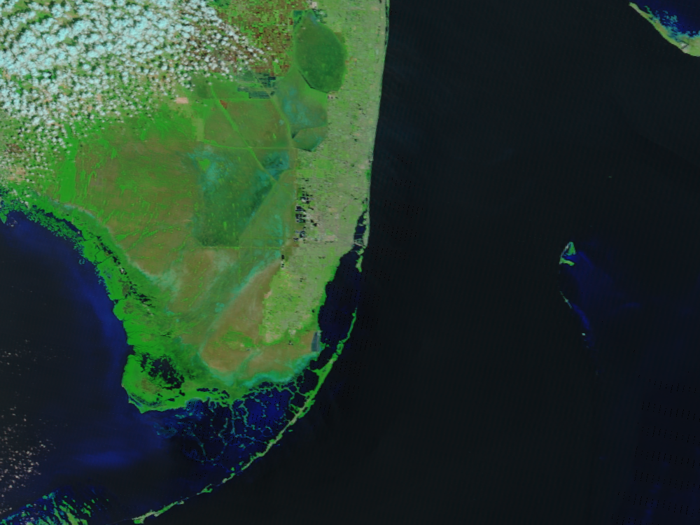
Fig. 8.2 GeoTIFF false color image created from the 19 March 2017 Terra MODIS test data centered on Miami, Florida.