The CRAS Legacy
Derived from the Latin “tomorrow,” CRAS has been a forward-looking numerical weather forecasting model for more than 25 years. It is fitting that the model was created at the UW-Madison Space Science and Engineering Center and Cooperative Institute for Meteorological Satellite Studies (CIMSS), the birthplace of satellite meteorology.
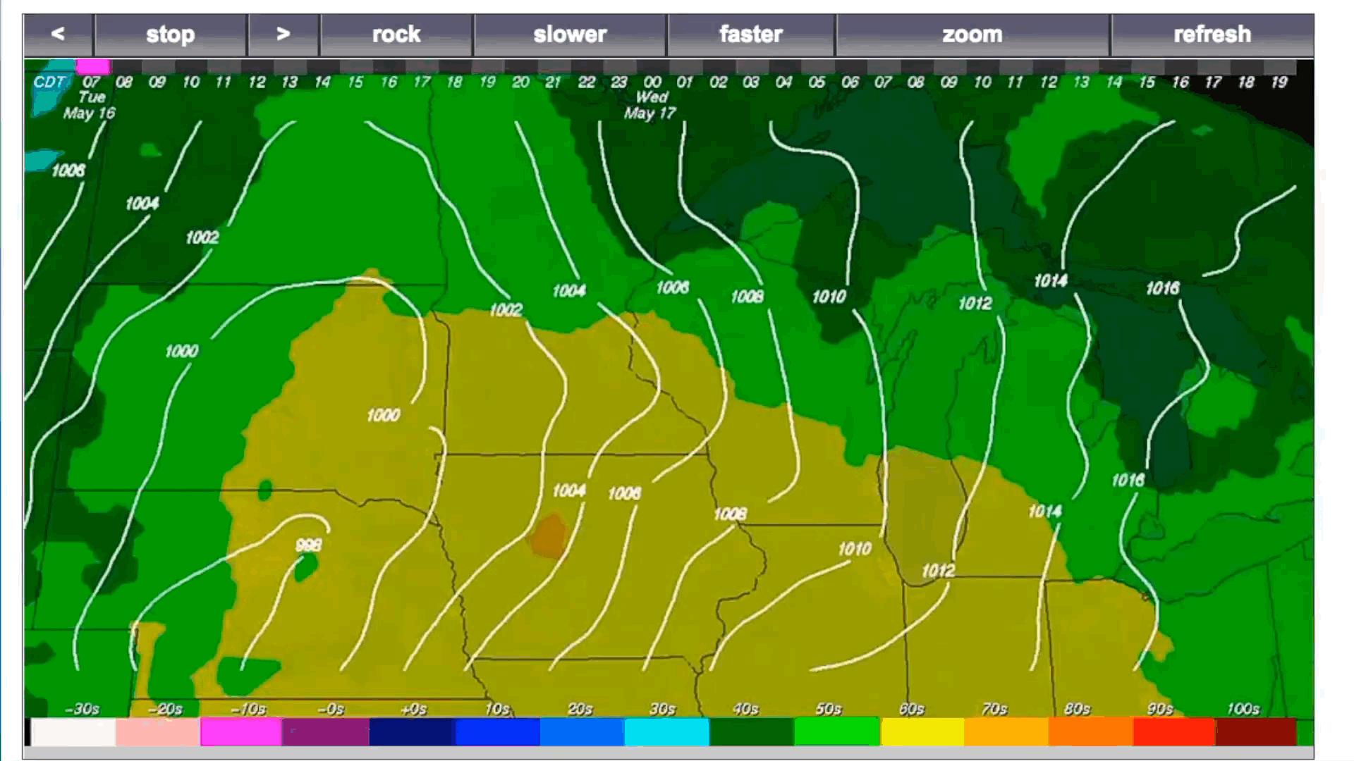
A midwest CRAS temperature/sea level pressure forecast loop, click to play. View up to date forecasts on the CRAS page. Credit: SSEC/CIMSS
Formally called the CIMSS Regional Assimilation System, it was one of the early conceptual ideas for weather modelling that used satellite data from the Geostationary Operational Environmental Satellites (GOES). It focused on regional areas, with smaller grids and increased resolution.
In 1975, GOES-1 changed the way researchers looked at weather. With the advent of near-continuous data coverage over the continental United States and improvements in computer processors here on Earth, numerical forecast modelling quickly took off. By 1980, GOES-4 accelerated progress with its advanced instrumentation that opened a new chapter for researchers designing increasingly complex weather models.
“In the early days, our goal was to show what we could do with satellite data in terms of forecasting,” says Bob Aune, retired NOAA researcher stationed at UW-Madison’s CIMSS. “At the time, there was little understanding of how to translate the GOES satellite data into something useful for operational meteorology.”
Aune is one of the original creators of CRAS. His own career launched around the time GOES-1 was headed into geosynchronous orbit. At the time, he was working at NASA Goddard Space Flight Center in Maryland, where he began to develop ways to integrate temperature and moisture profiles taken from the GOES-4 VISSR Atmospheric Sounder (VAS) into computer models. A few years later, given his research interests, it was a natural step for him to join the NOAA team at CIMSS where other scientists were conducting research on the latest satellite meteorology methods and tools. Once at CIMSS, he began working on the CRAS model, which was based on an older Sub-Synoptic Model (originally designed by scientists in Australia and brought to CIMSS by SSEC scientist William Smith) used to make nationwide weather forecasts.
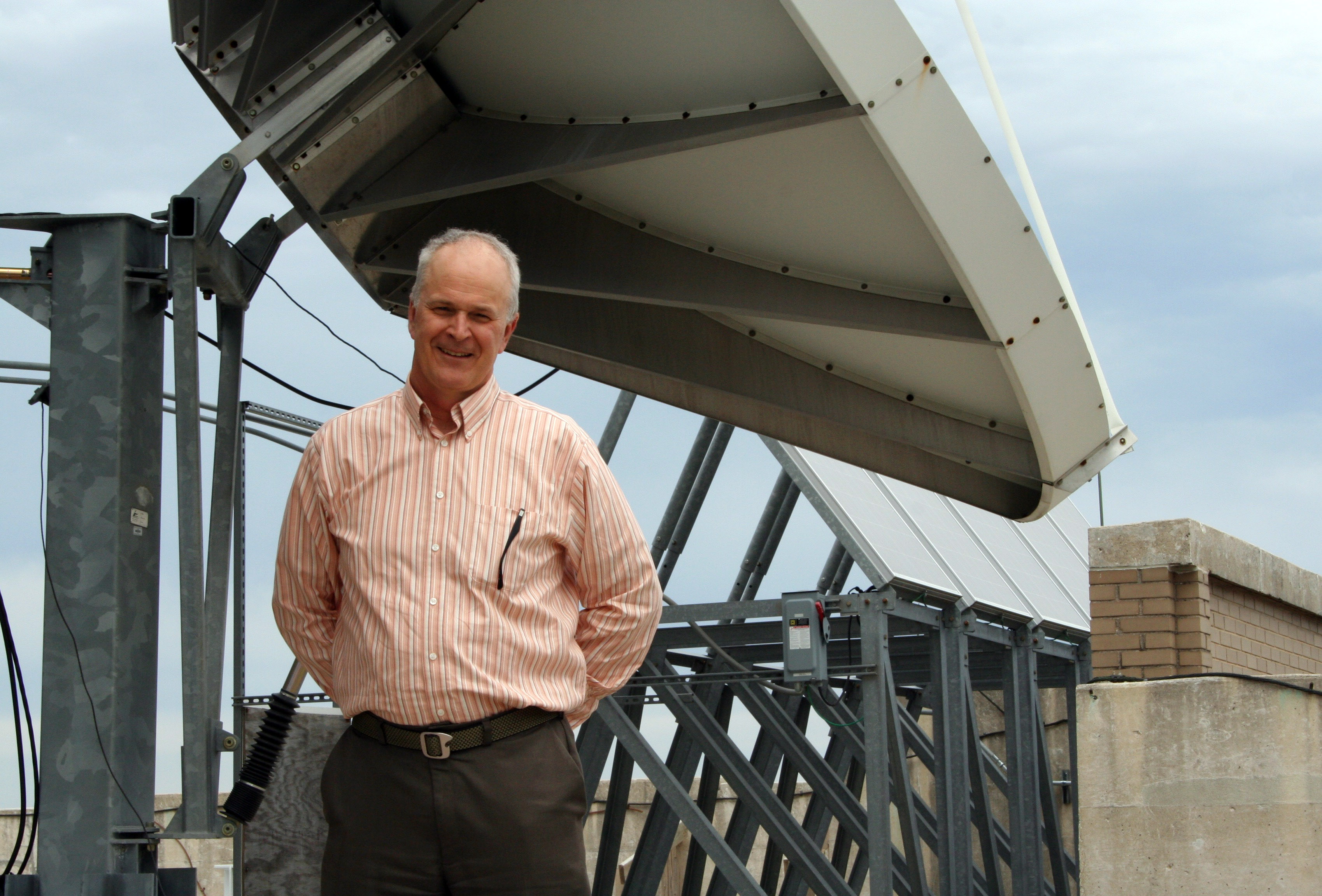
Bob Aune, recently retired NOAA researcher at CIMSS led the CRAS project for more than 25 years.
According to Aune, the GOES-4 data was especially helpful because it included valuable measurements of radiation emitted from the Earth. These measurements could then be used to validate numerical forecasts by converting model parameters like temperature and moisture into radiances, which effectively got the models and satellites speaking the same language.
Prior to these geostationary satellite measurements, the standard for collecting data were radiosonde measurements from weather balloons and data from polar orbiting satellites. These methods, however, were limited in their ability to continuously collect data over a fixed area because weather balloons are launched about once every 12 hours and polar orbiters take several hours before scanning the same area again.
Aune notes that the lack of weather data over places like the oceans, left forecasters with limited means to create accurate forecasts. GOES data was a game changer because it filled the missing data gaps of the other conventional methods. As new GOES satellites replaced older models, the CRAS program became popular for meteorologists and forecasters, especially those along the U.S. west coast and in other countries like Chile, South Africa and Australia.
Entering the early 90s, the CRAS model continued to improve, thanks in part to constant evaluation over the years. Each CRAS forecast would be directly compared to actual observed events, just hours later, allowing for ongoing refinements.
By the time GOES-8 launched in 1994, usage of GOES data was becoming more widespread and better understood in the Numerical Weather Prediction (NWP) community, and according to Aune, the CRAS model hit a milestone in its accuracy, with forecasts extending from several hours, to eventually several days.
At its peak, the CRAS model had dozens of users worldwide, and Aune attributes much of its success to its accessible design and ability to run on basic computers.
“CRAS existed in an era when you didn’t need heavy computing power,” says Jordan Gerth, CIMSS researcher. “One advantage was its accessibility for meteorologists around the world who didn’t have the computing resources or bandwidth needed to run other computationally intensive programs.”
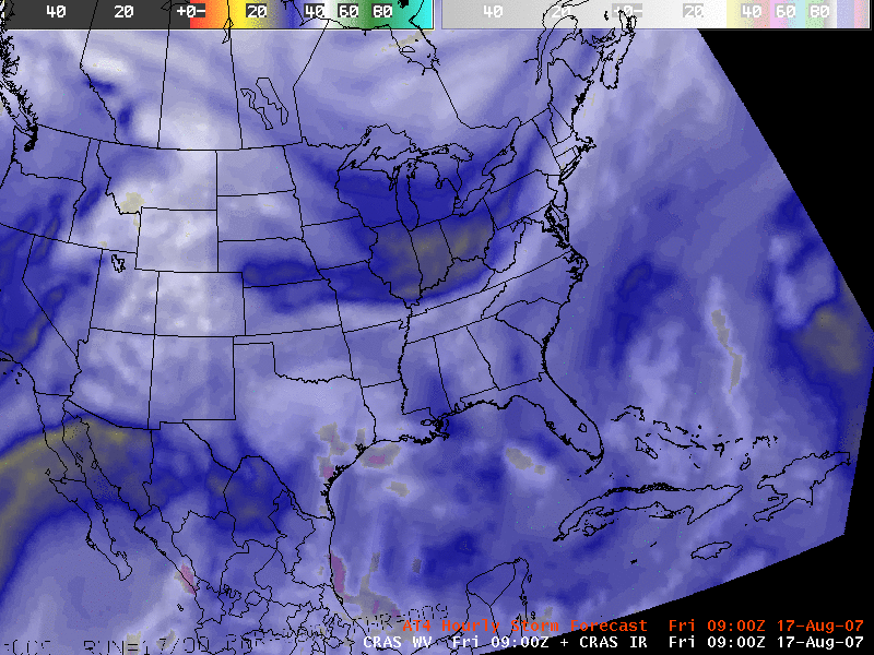
A water vapor + IR imagery loop based on CRAS forecasting. Credit: SSEC/CIMSS
Gerth worked with the CRAS model from 2007 through 2012, particularly to create an analysis of satellite-estimated moisture, a component of his Master’s thesis at the University of Wisconsin-Madison that investigated the sensitivity of computer models to subtle changes in observations. Looking back, he says it’s easy to take for granted our daily usage of satellite data to inform computer models. However, because of research with CRAS and other early weather models, the field of satellite meteorology has made weather predictions better. And the unique ability of CRAS to simulate satellite imagery is now a capability of today’s more sophisticated models.
In the coming months, Aune and others will begin the process of phasing out some of the CRAS services. Its ultimate future is unknown, but Aune is encouraged by the other research projects that have stemmed, in part, from the CRAS work over the decades and have received funding from NOAA and NASA.
The High Resolution Rapid Refresh (HRRR) model validation, for example, is rooted in the CRAS legacy. CIMSS scientists have developed an automated ranking method to quickly assess the accuracy of HRRR model forecasts through comparison of observed and simulated GOES infrared brightness temperatures. Another descendant of CRAS is the Satellite Data Assimilation for Tropical Storms (SDAT), which studies the influence of different satellite information on high impact weather forecasts, with the goal of improving Atlantic hurricane forecasts.
Aune also contributed to the development of “nearcasting,” which makes use of three channels of infrared water vapor data gathered from the GOES sounder, and is used to predict severe weather outbursts one to six hours in advance. This technique fills the gap between radar “nowcasts,” which predict weather from the zero to one-hour range, and NWP forecasting models which predict weather more than eight hours in advance.
“Even though CRAS comparatively lagged behind the competition in complexity, it remained competitive over the years by using observations from satellites to update its initial state,” says Aune. “After all, numerical weather prediction is an initial value problem.”
by Eric Verbeten