Monthly News Summary – February 2011
- DISC Drill Breaks Record at WAIS Divide
- SSEC and CIMSS Take AMS Conference by Storm
- SSEC Wows at WeatherFest
- Science Inspires Art at the AMS Conference
- CIMSS/SSEC participates in NOAA/NESDIS Constituent Meeting
- Heidinger and Pavolonis Receive NOAA Bronze Medals
- Schmit Interviewed by Space News about the GOES-R ABI
DISC Drill Breaks Record at WAIS Divide
Developed by engineers of the UW-Madison Space Science and Engineering Center Ice Drilling Design and Operations (IDDO) group, the Deep Ice Sheet Coring (DISC) drill has passed the previous record depth for US ice drilling. On 28 January 2011 the drill reached a depth of 3331 meters (10,928 feet), breaking the previous record of 3053 meters set in 1993 in Greenland.
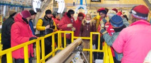
The drilling and core handling crews celebrate record-breaking effort. Photo: Mark Twickler
The DISC drill is a “tethered” electro-mechanical drill that consists of a 16-meter down-hole portion (sonde) raised and lowered in the fluid-filled borehole by a winch via a cable approximately 15 mm in diameter.
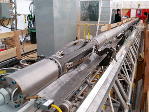
The DISC Drill sonde
The sonde consists of six distinct and separable sections:
- the cutter head assembly that actually cuts the ice,
- the core barrel in which up to 4 meters of core is collected,
- the screen section in which chips of ice resulting from the cutting operation are separated from the drilling fluid and stored,
- the motor/pump section that houses a pump to circulate the drilling fluid and motors to drive the pump and rotate the lower portions of the drill that cut the ice,
- the instrumentation section that contains controls for the pump and cutting motors as well as numerous sensors to monitor the drilling operation, and
- the upper section that provides for the termination of the cable and “anti-torques” that center the drill and provide a torque reaction point to prevent the entire sonde from rotating.
The cutter head, core barrel and screen section rotate while the sections above are restrained.
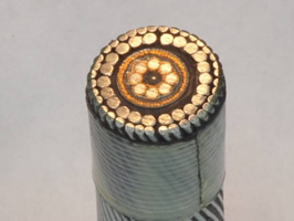
Cross-section of DISC Drill cable
The cable used at WAIS Divide is 3800 meters long and has multiple functions. First, it provides the support for lowering and raising the sonde. Second, the cable provides the electrical conductors to transmit power from the surface to the motors and instruments in the sonde. Finally, the cable houses optical fibers through which data are sent between the sonde and the surface control system.
The cable winch is electrically driven and is designed to have the smallest “footprint” possible.
As the borehole becomes deeper, a substantial amount of time is required to raise and lower the sonde. Consequently, ICDS engineers designed the winch to be operated at the fastest practical speeds. The DISC drill winch is capable of raising the sonde at a speed of 3 meters per second.
“The DISC drill is revolutionary technology,” said Alexander Shturmakov, director of engineering and research for IDDO. “Its electronic brain makes this drill more complex than any comparable device.”
Ice cores collected by the DISC Drill play an important role in the study of the history of Earth’s climate. By analyzing the gases, dust, ash, and other substances trapped in the layers of ice formed from annual snowfall in the Earth’s cold regions such as Greenland and Antarctica, scientists can reconstruct Earth’s climate thousands of years into the past. At the 3,300 meter mark, the ice (and the air trapped within it) is approximately 100,000 years old.
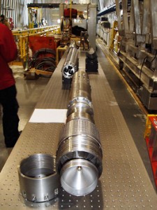
The ice cores produced by the DISC drill are 12.2 cm (4.8 inches) in diameter and up to three and one-half meters long. Deep inside the glacier, the pressure of the incredible weight of the overlying ice pushes on the borehole at all times, threatening to collapse it and trap the drill. Consequently, the shaft is filled with a fluid which provides the hydrostatic compensation necessary to prevent closure.
“Think of these cores as a giant library of ancient weather reports,” said Principle Investigator and Professor Emeritus Charles Bentley. “The scientific community decided what they needed for a new drill. They wanted lots of new capabilities. Their requests drove our design team and the result was the DISC drill.”

Professor emeritus Charles Bentley inspects the barrel of the Blue Ice Drill, another drill designed and built by the UW-Madison IDDO team.
The core is carefully preserved until it gets back to a laboratory in the US, where the ice is crushed in a vacuum to release the bubbles from their icy stasis. That yields a sample of air that was fresh tens of thousands of years ago. Climatologists can study the chemical composition of the atmosphere that existed during and before the last Ice Age.
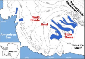
The location of the WAIS Divide drilling site.
The most significant characteristic of the West Antarctic Ice Sheet (WAIS) Divide project is the development of climate records with an absolute, annual-layer-counted chronology for the most recent 40,000 years. Lower temporal resolution records will extend back for approximately 100,000 years.
These records will enable comparison of environmental conditions between the northern and southern hemispheres, and the study of greenhouse gas concentrations in the ancient atmosphere, with a greater level of detail than previously possible. While similar projects have collected data from Arctic ice in Greenland, the WAIS project is the first Southern Hemisphere project to gather climate records of comparable time resolution and duration.
At 3331 meters, the drill designed and built at the UW-Madison set the new US record as the deepest US ice core drilled.
The Antarctic Sun, the publication of the National Science Foundation’s U.S. Antarctic Program, has published an in-depth article about the drilling achievement at the WAIS Divide.
SSEC and CIMSS Take AMS Conference by Storm
![]()
Seattle welcomed the 91st Annual American Meteorological (AMS) Conference on 24 – 28 January 2011 with open arms and mostly cloudy skies. The sun peeked through a few times, but for the most part, there was plenty of weather for the visiting meteorologists.
CIMSS Director Steve Ackerman, with Raj Pandya, was the co-director of this year’s conference, whose theme, “Communicating Weather and Climate,” emphasized the idea that two-way communication is essential for scientific research, education and serving the public.
Ackerman and Panya contributed video entries to the AMS blog, with discussions on how to use scientific data wisely and how to communicate the results effectively. Another set of videos explores effective communication with conference attendees.
Tom Whittaker co-chaired the Interactive Information and Processing Systems (IIPS) 27th annual Conference, held during the AMS gathering. The IIPS Conference is the longest running conference at the annual meeting, and this year attracted more than 190 presenters in nearly 40 sessions.
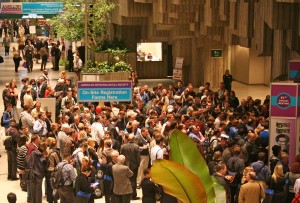

Crowds eagerly awaited the opening of the Exhibit Hall.
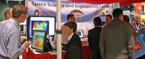
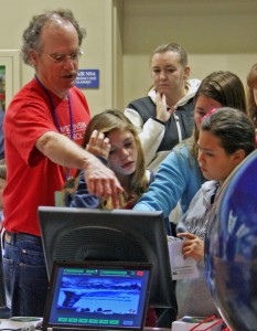
SSEC maintained an exhibit booth during the meeting demonstrating some of the Center’s latest research, providing close-up looks at the 3-D globe, and allowing visitors to sample the full release version of McIDAS-V’s visualization tools.
Margaret Mooney (center) demonstrates McIDAS-V visualization tools.
Rick Kohrs (left) takes the next generation of climatologists on a 3-D tour of the globe.
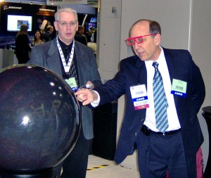
Dr. Louis W. Uccellini, Director of the National Weather Service, National Centers for Environmental Prediction (NCEP), gets a satellite view of Earth
(and sets a classy new fashion trend in eyewear).
Local media found their way to the popular SSEC booth and experimented with a new approach to broadcasting 3-D technology.
The weather outside remained mostly cloudy and wet for the Conference, but SSEC scientists and researchers made a strong case for advanced instrumentation in satellite studies, participated in poster sessions, gave informative seminars, and demonstrated new uses of software and hardware in a myriad of presentations, posters, and seminars.
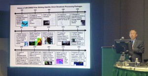
SSEC scientist Allen Huang presents a time-line of UW-CIMSS satellite developments.
On Sunday, 23 January 2010, the day before the official opening of the AMS Convention, the 10th Annual WeatherFest science fair drew an excited crowd of over 4,000 weather enthusiasts, all eager to experience dozens of interactive meteorology, oceanography and related science exhibits. WeatherFest is designed to inspire a love for math and science in children of all ages.
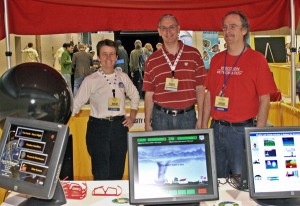
Margaret Mooney, Rick Kohrs, and Tom Whittaker ran the SSEC booth, introducing fascinated children and their parents to the world of satellite meteorology, helping them navigate several SSEC-created, weather-related applets on kiosk-mode touch monitors, and fielding questions from both young and old.

Margaret Mooney with a young researcher.
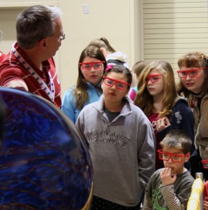
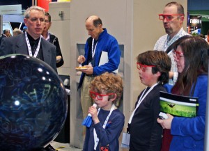
Rick Kohrs demonstrating the 3-D globe was a big hit, displaying the Earth’s climate and weather systems as they appear from space.
Tom Whittaker demonstrates SSEC-created weather apps.
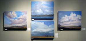
Science Inspires Art at the AMS Conference
Hard to miss at the 91st Annual American Meteorological (AMS) Conference was the Forecast: Communicating Weather and Climate Art Show. In a display co-directed by Steve Ackerman and Peggy LeMone and curated by Lele Barnett, more than 30 regionally, nationally, and internationally recognized artists based in Washington filled the 2nd Floor corridor of the Seattle Convention Center with spectacular photography, dynamic sculpture, stunning paintings and abstracts, and more.

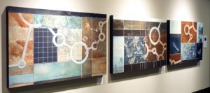
The exhibit opened on Monday, 24 January 2011, and will continue through 9 April 2011. A private opening reception at the exhibit for AMS donors and collaborating artists and scientists followed by a public reception was held on the first day of the exhibit from 7-9 pm.
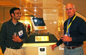
Steve Ackerman (right) examines an artwork by Deanna Pindell (artist – not pictured) and Ankur Desai (scientist – left). Pindall and Desai discuss the work on the AMS blog.
An on-line catalog of the Art Show is available.
CIMSS/SSEC Participates in NOAA/NESDIS Constituent Meeting
At the invitation of NOAA/NESDIS Assistant Administrator Mary Kicza, CIMSS/SSEC’s Margaret Mooney participated in a constituent roundtable in Washington, D,C at the Federation of Earth Science Information Partners (ESIP) winter meeting on 5 January 2011.
Mooney met with Ms. Kicza and six other ESIP members to discuss the new NOAA and NESDIS strategic plans unveiled at the ESIP conference. Among other topics, Mooney promoted smart phones and handheld devices as one of the best ways for NOAA/NESDIS to engage weather and climate data consumers in the development of future products and services.
Heidinger and Pavolonis Receive NOAA Bronze Medals
Andy Heidinger and Mike Pavolonis were selected as recipients of the 2010 NOAA Bronze Medal.
Heidinger and Istvan Laszlo (STAR in Washington, DC) were recognized “For developing an enhanced production system for satellite-based real-time radiation data from NOAA’s operational geostationary satellites.”
Pavolonis was recognized “For providing near real-time volcanic ash information in the critical period following the eruption of the Eyjafjallajökull volcano.”
In addition, Andrew Heidinger of the Advanced Satellite Products Branch (ASPB) was selected as NOAA Employee of the Month for January 2011. Heidinger is being recognized in particular for delivering the first externally-developed climate data record (CDR) dataset, PATMOS-x, to the National Climatic Data Center (NCDC) as part of its CDR program.
Schmit Interviewed by Space News about the GOES-R ABI
An article (“GOES-R Weather Satellite Program Hits Key Milestones”) on the Geostationary Operational Environmental Satellite (GOES)-R Advanced Baseline Imager (ABI) was published by Space News. The article includes the status of the spacecraft and instrument, and potential applications. Also included is a figure of simulated ABI images of Hurricane Katrina and an interview with Tim Schmit.
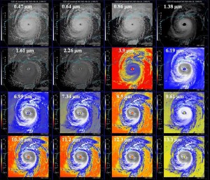
Image from the Space News article: 2005’s Hurricane Katrina is depicted in the 16 spectral bands that the Advanced Baseline Imager will be capable of producing. Current operational instruments produce imagery in only five spectral bands.