Monthly New Summary – January 2011
- SSEC Scientist Sanjay Limaye Explains Venus Mission Status
- CIMSS Hourly AMVs Used in U.S. Navy Model
- Chian-Yi Liu Describes Advances in Thunderstorm Prediction
- AGU Presentation Describes Radiative Effects of Asian Wildfires
- Companion Publications Describe AVHRR Capabilities
- Manuscript Published
SSEC Scientist Sanjay Limaye Explains Venus Mission Status
SSEC scientist Sanjay Limaye is quoted in an AP news article explaining the status of the Akatsuki Venus Probe.
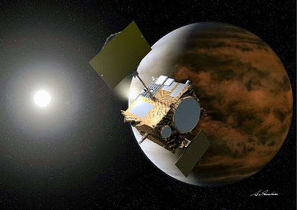
In this artist’s rendering by Akihiro Ikeshita released via Japan Aerospace Exploration Agency (JAXA), Japanese probe Akatsuki is reaching Venus, right. Probe Akatsuki on Tuesday, Dec. 7, 2010, reached Venus and prepared to enter orbit on a two-year mission that would mark a major milestone for Japan’s space program and could shed light on the climate of Earth’s mysterious neighbor. (AP Photo/Akihiro Ikeshita via JAXA) EDITORIAL USE ONLY
CIMSS Hourly AMVs Used in U.S. Navy Model
In the week of 09 December 2010, the United States Navy Fleet Numerical Meteorology and Oceanography Center (FNMOC) began operationally assimilating hourly Atmospheric Motion Vectors (AMVs) derived by the Cooperative Institute for Meteorological Satellite Studies (CIMSS) from MTSAT and GOES-West into their global data assimilation and modeling system.
CIMSS has been supplying the Naval Research Laboratory (NRL) in Monterey with the hourly AMVs on an experimental basis for the past two years. A research collaboration between CIMSS and NRL demonstrated the positive impacts of the hourly assimilation on model forecasts in a series of experiments and case studies. The hourly AMV observation impacts were then put through a brief beta test trial with the FNMOC operational 4D variational data assimilation system, and deemed beneficial to forecast skill.
Chian-Yi Liu Describes Advances in Thunderstorm Prediction for UW Press Release
CIMSS Scientist Chian-Yi Liu describes his research on thunderstorms in an article released by UW Campus Communications.
AGU Presentation Describes Radiative Effects of Asian Wildfires
A poster entitled “Radiative effects due to tropospheric ozone and carbonaceous aerosol enhancements caused by Asian wildfires during Spring, 2008″ was presented at the American Geophysical Union Fall meeting 12-17 December 2010 in San Francisco, CA. The poster describes results from collaborative studies by the Cooperative Institute for Meteorological Satellite Studies (CIMSS) and the NASA Langley Research Center using the Real-time Air Quality Modeling System (RAQMS) simulations and Langley Fu-Liou radiative transfer model to evaluate the radiative forcing due to emissions from fires in Kazakhstan, Siberia, and Thailand during April 2008.
Differences between the RAQMS simulations with observed fires and no Asian fire emissions are used to determine the perturbations due to Asian wildfires. The predominant effect at the surface is negative forcing. The largest is of the order of -30 to -60 W/m2 near the fire zone. The calculated results depend significantly on the predicted cloudiness as well as the vertical distribution of black and organic carbon aerosols.
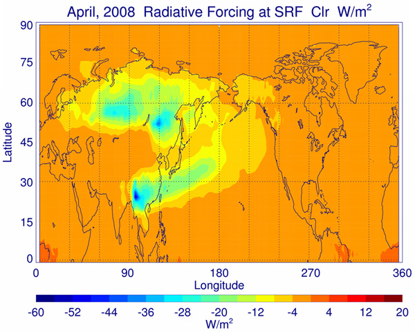
Monthly averaged surface clear sky radiative forcing values for April 2008 due to the Asian wildfire emissions.
Companion Publications Describe AVHRR Capabilities
Two companion papers describe a calibration of the Advanced Very High Resolution Radiometer’s (AVHRR) visible and NIR channels – a data record which stretches from the present back to 1978 – covering four versions of the instrument flown on 15 separate satellites:
- Andrew K. Heidinger; William C. Straka III; Christine C. Molling; Jerry T. Sullivan; Xiangqian Wu: 2010. Deriving an inter-sensor consistent calibration for the AVHRR solar reflectance data record.
International Journal of Remote Sensing, Volume 31 Issue 24, 6493 – 6517 - Christine C. Molling; Andrew K. Heidinger; William C. Straka III; Xiangqian Wu: 2010. Calibrations for AVHRR channels 1 and 2: review and path towards consensus.International Journal of Remote Sensing, Volume 31 Issue 24, 6519 – 6540
Heidinger et al. present a calibration in which AVHRR reflectances from channels 1 and 2 from differing polar-orbiting satellites are radiometrically tied to each other and to MODIS. Calibration values are provided for all AVHRRS from TIROS-N through Metop-A and NOAA-19. This is the first time these channels on all AVHRRs have been calibrated in a single consistent way.
Molling et al. examine the challenges related to calibrating AVHRR visible and NIR channels and lists a group of data sources and techniques that the calibration community is urged to use. Heidinger et al. 2010 is mentioned as a calibration that uses these sources and techniques. Molling et al. argue that if the techniques are used, resulting calibrations will agree with each other well enough to be considered in consensus, and will therefore allow AVHRR channels 1 and 2 to be used for long term climate studies.
A manuscript entitled “An objective methodology for infrared land surface emissivity evaluation” has been published in the Journal of Geophysical Research (115, D22308, doi: 10.1029/2010JD014249). Co-authors are Zhenglong Li, Jun Li, Xin Jin (CIMSS), Tim Schmit (STAR), Eva Borbas (CIMSS) and Mitch Goldberg (STAR).