Monthly Summary News – November 2010
- AmericaView Fall Meeting Hosted by SSEC
- WAIS Divide Project Makes Headlines
- Summer/Fall 2010 Through the Atmosphere Published
- Rooftop Cam Captures Fog Bank
- Lindstrom Presents Distance Learning Modules
- Cloud Remote Sensing Papers Published
AmericaView Fall Meeting Hosted by SSEC
On 10-13 October 2010, scientists, educators, and students from across the country converged on the Pyle Center in Madison, WI, for the AmericaView Annual Fall Technical Meeting. Sam Batzli, director of the WisconsinView program at SSEC, served as host for the meeting.
AmericaView, a consortium of university-led, state-based organizations, promotes and develops high-speed processing and rapid delivery of remotely sensed data to state and local users across the United States.
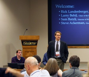
Jim Landenberger, Executive Director of AmericaView, welcomes attendees.
Near perfect weather contributed to an excellent experience for the seventy attendees. Two full days of meetings included sixteen talks, eighteen posters, six workshops, and a banquet. Presentations and workshops (see agenda) focused on three primary topical areas: education/outreach; research; and technology.
Liam Gumley (SSEC) delivered the keynote address discussing MODIS (MODerate resolution Imaging Spectroradiometer) and VIIRS (Visible/Infrared Imager Radiometer Suite).
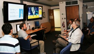
Jordan Gerth and Tim Schmit (from left) demonstrate the CAVE (CIMSS Analysis and Visualization Environment) to a group of attendees.
Tours demonstrated SSEC’s 3-D Science-Sphere, CAVE, Data Center, and rooftop. The meeting concluded with an all-day field trip to the International Crane Foundation and a geology tour of Devil’s Lake.
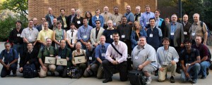
AmericaView attendees.
Logistical and technical support was provided by Maria Vesays, Dan Pasowicz, Ben Spair, Debbie Schoreder, and Bill Bellon. Volunteer tour guides included Mark Hobson, Margaret Mooney, Jordan Gerth, Tim Schmit, Jerry Robaidek, Bob Holtz, and Gary Wade.
WAIS Divide Project Makes Headlines
The Western Antarctic Ice Sheet (WAIS) Divide project in central West Antarctica continues to garner national attention:
A talk by Lee Hotz, science columnist for the Wall Street Journal, who visited WAIS Divide last seaso, highlights the project.
An online article by the NSF-funded Antarctic Sun discusses the National Ice Core Laboratory core processing line.
Another article by the Antarctic Sun gives more detailed view of the WAIS Divide project.
There is also an accompanying Wall Street Journal video, entitled ‘Unlocking Antarctica’s Secrets,’ that can be viewed via the WAIS Divide web site.
The Project collects deep ice cores using a state of the art Deep Ice Sheet Coring (DISC) drill. These ice cores, containing bubbles of atmosphere trapped hundreds of centuries ago, enable studies of greenhouse gas concentrations far into the past.
As a reminder, the Wall Street Journal ran a story about the WAIS project on the front page of their 29 May 2010 issue.
Summer/Fall 2010 Through the Atmosphere published
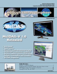
Through the Atmosphere is issued in both magazine form and online.
If you would like to be added to our mailing list or be notified when new issues are posted online, please contact Maria Vasys.
Your feedback is important to us. Please let us know if you have comments, suggestions, questions or concerns.
Amazing time lapse images from the AOSS Building’s rooftop webcam captured very heavy fog banks rolling in from the northwest and enshrouding the west end of the UW campus. Notice the circulation that develops over the lake toward the end of the loop. Both the north and northwest cameras grabbed footage of the fog.
The CIMSS Blog also featured footage of the fog bank.
Lindstrom Presents Distance Learning Modules
On 4 and 7 October 2020, Scott Lindstrom presented the Virtual Institute for Satellite Integration Training (VISIT) distance learning modules: The University of Wisconsin (UW) Nearcasting Product and The UW Convective Initiation Product.
Staff from the National Weather Service forecast offices at Riverton, Wyoming and Des Moines, Iowa, participated in the VISIT lessons.
On 20 October 2010, Lindstrom led the VISIT distance learning module: Interpreting Satellite Signatures.
Staff from the National Weather Service forecast office at Lubbock, Texas, participated in the VISIT lesson.
In addition, a number of posts were added to the Cooperative Institute for Meteorological Satellite Studies (CIMSS) Satellite Blog, including Geostationary Operational Environmental Satellite (GOES), Moderate Resolution Imaging Spectroradiometer (MODIS), and Advanced Very High Resolution Radiometer (AVHRR) images of thunderstorms that produced historically large hail in southern Arizona on 5 October 2010.
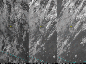
GOES-11 (left panel), GOES-15 (center panel), and GOES-13 (right panel) visible images showing multiple clusters of severe thunderstorms moving across southern Arizona on 5 October 5, 2010.
Multifunctional Transport Satellites (MTSAT), Morphed Integrated Microwave Imagery at CIMSS (MIMIC), and Moderate Resolution Imaging Spectroradiometer (MODIS) captured images of Super Typhoon Megi as it made landfall over the Philippines as a very strong Category 5 tropical cyclone on 18 October 2010.
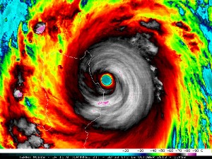
A Terra MODIS 11.0 µm IR image showing the well-defined eye and surrounding concentric eyewall structure of Super Typhoon Megi as it approached the Philippines on 19 October. The coldest infrared brightness temperature seen at that time was -82º C (purple color enhancement) to the south of the eye.
Cloud Remote Sensing Papers Published
Andrew Heidinger and Michael Pavolonis were co-authors on two journal articles on cloud remote sensing that appeared this week. The lead author on the first article was Gala Wind of NASA Goddard Space Flight Center. This article described a new technique for multi-layer cloud detection.
The second paper was led by Gang Hong of Texas A&M University and described a new technique using infrared observations to distinguish between opaque and non-opaque ice clouds.