Monthly News Summary – June 2010
- Satellite Images of Oil Slick in the Gulf of Mexico
- Monitoring of Eyjafjallajokull Volcanic Ash
- GOES-R Proving Ground Enters Third Week
- Wall Street Journal Features WAIS Divide DISC Project
- IMAPP Virtual Appliance version 1.0 Available
- CIMSS VISIT Activities
- Ackerman Honored by NASA
- RSP gets VIP tour of SSEC
- Publication
Satellite Images of Oil Slick in the Gulf of Mexico
Geostationary Operational Environmental Satellite (GOES-13) visible and shortwave IR images continue to reveal the oil slick spreading from the ruptured well deep beneath the surface of the Gulf of Mexico.
Moderate Resolution Imaging Spectroradiometer (MODIS) true color and false color images acquired by the Space Science and Engineering Center (SSEC) MODIS Direct Broadcast ground station (and processed for display on the SSEC MODIS Today site) are used to identify and track the movement of the expanding oil slick.
In addition, Sea Surface Temperature (SST) products derived from MODIS and Advanced Very High Resolution Radiometer (AVHRR) data revealed that the oil slick exhibited sea surface temperature values that were often 5-10 degrees F cooler than the surrounding waters in the northern Gulf of Mexico.
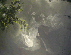
MODIS true color and false color images showing the large oil slick just off the coast of Louisiana.
Monitoring of Eyjafjallajokull Volcanic Ash
Experimental STAR and Cooperative Institute for Meteorological Satellite Studies (CIMSS) continue to make volcanic ash products available to the London Volcanic Ash Advisory Center in near-realtime.
In addition, the CIMSS Satellite Blog updates regularly with new imagery and products relevant to the current week’s eruptions.
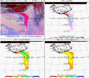
The NOAA/NESDIS/STAR and Cooperative Institute for Meteorological Satellite Studies (CIMSS) volcanic ash products are shown for an eruption of Eyjafjallajokull, in Iceland, on 6 May 2010 at 12:00 UTC. A false color image (top left), the ash mass loading (top right), ash cloud height (bottom left), and ash particle size (bottom right) are displayed in the four panels.
Brad Pierce, a NOAA researcher stationed at the UW-Madison Space Science and Engineering Center, has been asked to join the NOAA Volcanic Ash Science Team, which is part of the newly formed NOAA Volcanic Ash Working Group. The Science Team is composed of NOAA experts currently performing volcanic ash modeling and observation research and is charged with determining the limitations of current capabilities, identification of the major science issues and describing future efforts to improve volcanic ash observation and prediction.
GOES-R Proving Ground Enters Third Week
The “Satellite Proving Ground,” NOAA’s Cooperative Institute for Meteorological Satellite Studies (CIMSS) test bed for new satellite products that are not yet operationally available in the National Weather Service (NWS) Advanced Weather Information Processing System (AWIPS) environment, has reached the middle of its five-week run.
The Proving Ground allows interested NWS forecast offices to become involved in the early evaluation of these new satellite products by adding them to their local AWIPS workstations via Unidata Local Data Manager (LDM) subscription.
To follow the activities at the third week of CIMSS participation at NOAA Hazardous Weather Testbed, take a look at their blog. Currently participating: Dan Hartung and Chris Rozoff.
Wall Street Journal Features WAIS Divide DISC Project
The Western Antarctic Ice Sheet (WAIS) Divide project in central West Antarctica collects deep ice cores using a state of the art Deep Ice Sheet Coring (DISC) drill. These ice cores, containing bubbles of atmosphere trapped hundreds of centuries ago, enable studies of greenhouse gas concentrations far into the past.
The Wall Street Journal (WSJ) ran a story about the project on the front page of its 29 May 2010 issue.
There is also an accompanying WSJ video, entitled “Unlocking Antarctica’s Secrets.”
The WSJ video can also be viewed via the WAIS Divide web site.
IMAPP Virtual Appliance version 1.0 Available
The Direct Broadcast capability of NASA’s Terra and Aqua spacecraft provide new remote sensing capabilities for the observation of planet Earth. The International MODIS/AIRS Processing Package (IMAPP) allows ground stations capable of receiving Earth-Observing System (EOS) direct broadcasts to create a wide variety of products.
The IMAPP Virtual Appliance is a stand-alone processing system for MODIS, AIRS, and AMSR-E data acquired by direct broadcast from the Terra and Aqua spacecraft. It is implemented in the form of a VMware virtual machine, which is easy to install and run on platforms including:
- Microsoft Windows (XP, Vista, 7)
- Intel Linux
- Apple OS X
The minimum requirements to run the IMAPP Virtual Appliance are:
- VMware Player (a free download for Windows and Linux), or VMware Fusion for OS X,
- 1 CPU, 512MB of RAM, and a minimum of 20GB of disk space,
- an Internet connection.
The IMAPP Virtual Appliance version 1.0 and complete information concerning this software is now available for download via the IMAPP website.
Scott Lindstrom (CIMSS) led the Virtual Institute for Satellite Integration Training (VISIT) distance learning module “Interpreting Satellite Signatures” on 5 May 2010. Staff from the National Weather Service forecast office at Lubbock, Texas, participated in the VISIT lesson.
In addition, the CIMSS Satellite Blog was updated with a variety of satellite images covering such topics as the historic heavy rainfall event at Nashville, Tennessee on 2 May 2010, a major blowing dust event in the Pacific Northwest on 3 May 2010, and an update on the Gulf of Mexico oil slick on 4 May 2010.
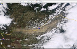
Terra MODIS true color image (visualized using Google Earth) showing a large blowing dust plume over eastern Washington on 3 May 2010. Wind gusts as high as 80 mph reduced surface visibilities and caused a number of traffic accidents (some along Interstate 90).
Steven Ackerman, Director of the UW-Madison Cooperative Institute for Meteorological Satellite Studies, was presented with NASA’s Exceptional Public Service Medal. The medal is awarded “to any individual who was not a Government employee during the period in which the service was performed. The award is given for exceptional contributions to NASA’s mission.”
The citation on Dr. Ackerman’s award read: “For outstanding, long-term contributions to NASA as a scientist, community leader, and leader of the Senior Review Science Panel to extend Earth Science operating missions.”
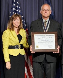
Lori Garver, Deputy Administrator of NASA, and Steven Ackerman
Following the initiative of Jenny Hackel, SSEC hosted staff from Research and Sponsored Programs (RSP) on two occasions this spring. Jenny wanted to acknowledge RSP’s contributions to our work while showcasing results of some of the projects that RSP helped facilitate over the years. The red carpet tours included stops to the CAVE, the Schwerdtfeger Library, the Data Center, the 3D Globe, and of course, the roof.
Following these visits RSP staff sent several thank-you notes, including one from Dave Schuster who wrote:
“I wanted to let you know how much I along with the rest of RSP appreciated and enjoyed the tour of your facilities yesterday. It is very helpful to us on this side of the research to see the results of the funding being secured. Rather than just being paperwork, it is good to see what is actually taking place in the departments we work with. The afternoon was well planned and informative. Thank you for taking your time to share with us your work and accomplishments.”
Bi, L., J. Jung, M. Morgan, and J. Le Marshall, 2010: A Two-Season Impact Study of the WindSat Surface Wind Retrievals in the NCEP Global Data Assimilation System. Weather Forecasting, Vol. 25, No. 3, 931-949.