Monthly News Summary – December 2009
GOES-10 Ends Over a Decade of Service
Geostationary Operational Environmental Satellite (GOES)-10 reached its end-of-fuel life and required decommissioning on 01 December 2009. Finally located at 60W longitude (after its eight operational years of service as the western GOES at 135W longitude), GOES-10 provided information for South American and other users.
GOES-10 was launched on 25 April 1997, and far exceeded its expected lifetime. GOES-10 supplied images to the end, including a Mesocale Convective Complex in South America.
A “Farewell to GOES-10” is on the Cooperative Institute for Meteorological Satellite Studies (CIMSS) Satellite blog, covering some of the many uses of the GOES-10 imager and sounder data.
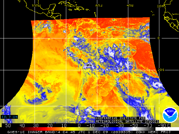
The final GOES-10 Imager infrared window image from 01 December 2009 at 04:45 UTC. The data were remapped before distribution.
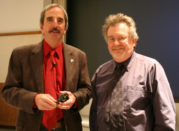
SSEC Director Hank Revercomb Delivers “State of the Center” Address
On 10 December 2009, Hank Revercomb gave his annual State of the Center Address to a capacity crowd at the Educational Science Building. Graduate School Dean Martin Cadwallader provided opening remarks.
Director Revercomb’s State of the Center address (as well as previous addresses) is available for download online in Powerpoint format.
WisconsinView Displays at the GIS Expo
Sam Batzli gave a presentation and staffed the WisconsinView booth at the Geographical Information Sciences (GIS) Expo held on November 20, 2009, in the Memorial Union’s Great Hall. The Expo was part of “GIS Day,” an international day of education about GIS and geography marked by local events held by thousands of organizations around the world.
GIS Day at the University of Wisconsin was part of National Geography Awareness Week, with the theme: “History – Education – Research – Application.” Over 40 organizations from the private and public sectors came to the Union to demonstrate GIS applications and geospatial technologies, research projects in the areas of GIS, cartography and remote sensing.
Dr. Batzli gave a presentation entitled “Better Access to Satellite Imagery through WisconsinView.” Since 2004 WisconsinView has made airborne and satellite imagery of Wisconsin available for free download over the Internet. As web-based geospatial technologies such as GoogleMaps become more commonplace, opportunities and challenges arise to share imagery in new ways. He described the steps taken at WisconsinView to facilitate access to imagery to a broader audience, including the development of “geo-jpegs” GoogleMaps mash-ups, and web mapping services.
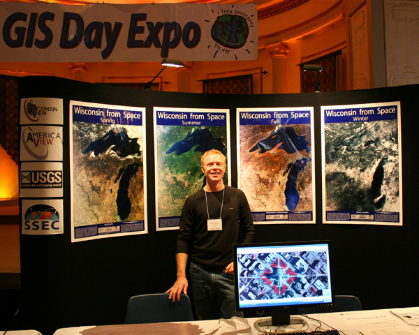
Sam Batzli single-handedly ran the WisconsinView booth at GIS Day.
The GIS Day Expo site has more information about the event and co-sponsors.
For more information and future notices about upcoming local “Geospatial” events, join the Spatial Information and Analysis Consortium campus-wide list.
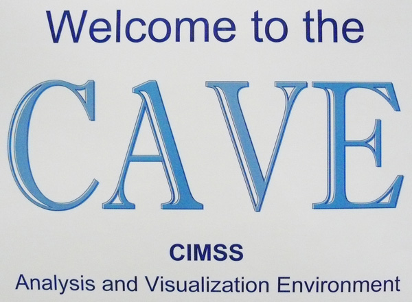
Please join us for 30-minute (or less) weather briefings in the CIMSS Analysis and Visualization Environment (CAVE), Room 248 of the Atmospheric, Oceanic and Space Sciences (AOSS) Building, every Tuesday and Thursday at 12:45 PM, starting 01 December 2009.
In designing the CAVE, we hoped these informal briefings would provide an opportunity to integrate the faculty, researchers, and students within the AOSS Building in discussions surrounding weather and remote sensing-related topics relevant to atmospheric trends. So, if you have something to share, are looking to learn, or are just interested in the forecast for tomorrow, please consider attending.
Jordan Gerth will serve as the discussion leader for the initial sessions. Others will lead briefings as we continue into 2010. The discussion leader will provide some initial dialogue and review the weather situation for roughly 15 minutes; presentations requiring preparation are welcome, but not expected. The second half of the discussion should be propelled by the audience.
The tentative plans are for the briefings to held on days the University is open; they will not be confined to the academic schedule. There will be a sign outside of Room 248 announcing if a briefing will take place on any given day. Our intent is to minimize conflicts with seminars, graduate courses, and other large group meetings.
If you have any questions, please contact Mark Hobson, the Space Science and Engineering Center Public Information Officer.
Brad Pierce Presents at the International Workshop on Air Quality Forecasting Research
Brad Pierce presented a talk entitled “Real-time Air Quality Modeling System aerosol and ozone assimilation and forecasting experiments during the NOAA ARCPAC field mission” at the International Workshop on Air Quality Forecasting Research, 02-03 December 2009 in Boulder, CO.
The talk summarized results from global ozone and aerosol assimilation and forecasting experiments conducted following the NOAA Aerosol, Radiation, and Cloud Processes affecting Arctic Climate (ARCPAC) mission in April 2008. Assimilation of real-time ozone measurements from the Microwave Limb Sounder (MLS) and Ozone Monitoring Instrument (OMI) and aerosol optical depth (AOD) measurements from the Moderate Resolution Imaging Spectroradiometer (MODIS) were found to have positive impact on Northern Hemisphere forecast skill for both ozone and aerosol extinction.
These studies provide risk-mitigation for utilization of ozone and aerosol measurements from Ozone Mapping and Profiler Suite (OMPS) and Visible/Infrared Imager/Radiometer Suite (VIIRS) on future National Polar-orbiting Operational Environmental Satellite System (NPOESS) within operational air quality prediction systems under development at the National Centers for Environmental Prediction (NCEP).
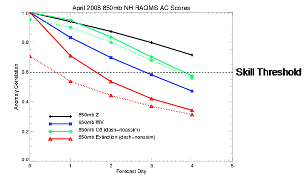
RAQMS 2.0×2.0 degree global geopotential height (black), water vapor (blue), O3 (green), and aerosol extinction (red) forecast skill with (solid) and without (dashed) ozone and aerosol assimilation during April 2008. The largest impacts are found for aerosol predictions which show useful skill out to 1.5 days with MODIS AOD assimilation and no skill without MODIS AOD assimilation. Assimilation of OMI ozone column improves Northern Hemisphere 850mb ozone forecasts with useful skill beyond 3.5 days. The 850mb ozone forecast skill is found to be better than water vapor but less then geopotential height forecast skill.
Paper Published on Satellite Observations of Cloud Liquid Water: A paper authored by Tom Greenwald (CIMSS) entitled “A 2 Year Comparison of AMSR-E and MODIS Cloud Liquid Water Path Observations” was published in Geophysical Research Letters. The article reports on the first ever extensive comparison of cloud liquid water path over the oceans observed by optical and passive microwave satellite sensors.
Manuscript on MODIS Arctic Cloud Detection Performance Accepted: A journal article on Moderate Resolution Imaging Spectroradiometer (MODIS) cloud detection performance with changing surface conditions in the Arctic and its implications for climate studies has been accepted for publication in the Journal of Climate. Title of the article is “Errors in Cloud Detection Over the Arctic Using a Satellite Imager and Implications for Observing Feedback Mechanisms.” Authors are Yinghui Liu (Cooperative Institute for Meteorological Satellite Studies, CIMSS), Steven A. Ackerman (CIMSS), Brent C. Maddux (CIMSS), Jeffrey R. Key (NESDIS/STAR), and Richard A. Frey (CIMSS).
Paper Accepted for Publication: A paper authored by Andre. Heidinger, Michael Pavolonis and others was accepted this week for publication by the Journal of Geophysical Research. The paper explores the impact of the channel selection on the future NOAA imagers in the context of cloud height estimation. The paper is accessible online.