Newly updated CIMSS algorithm shows total precipitable water over land, sea
Scientists at the Cooperative Institute for Meteorological Satellite Studies (CIMSS) at the University of Wisconsin-Madison have upgraded an algorithm they developed nearly a decade ago to provide weather forecasters with seamless, satellite-based total precipitable water (TPW) values from around the globe—over sea and, now, land.
TPW is the total amount of water vapor contained in a column of moist air, from the Earth’s surface to the very top of the atmosphere. In essence, it is all the moisture (within that imaginary column) that could potentially be precipitated as rain or snow. TPW is an important metric for weather forecasting, especially for predicting and tracking tropical cyclones and other severe weather in the humid tropics.
In 2003, CIMSS scientists Tony Wimmers and Chris Velden set out to fill in the gaps of TPW data collected by polar-orbiting satellites, which gather swaths of data above the Earth’s surface roughly every 1-18 hours (compared to geostationary satellites, which gather data continuously). The scientists wanted to create an algorithm that would apply an existing “morphing” technique to TPW data, but they had only ever used the technique for flat values—not a volume, such as a column of TPW.
“I didn’t think it would work,” laughs Wimmers. “But, it turns out, it provides a very accurate approximation over the time gaps that we are filling in… I think it surprised everyone.”
The morphing technique “requires special care,” says Wimmers. “You have to make sure you are not violating too many assumptions about how water vapor moves. But it is a pretty simple process.”
The algorithm uses data from seven microwave instruments from U.S. military, NOAA, Japanese, and European satellites, and incorporates wind values from the U.S. National Weather Service’s global weather model, the Global Forecast System (GFS), and accounts for water vapor motion. The algorithm can “push” the data forward from the time of the measurement about 1-10 hours, and also push it backward about 1-10 hours, Wimmers explains.
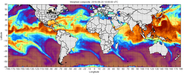
“Morphed composite” satellite imagery of total precipitable water over the world’s oceans from August 19-22, created using the original version of MIMIC-TPW. Click for animation.
“That way, you can take one observation and make it apply to a long stretch of time,” he says. “That’s what enables you to have a natural-looking visualization.”
Wimmers and Velden went public with the Morphed Integrated Microwave Imagery at CIMSS – Total Precipitable Water (MIMIC-TPW) algorithm in 2007, and it has been an integral tool for tropical weather analysis ever since.
Still, there was room for improvement, particularly to better serve coastal forecasters.
Some polar-orbiting satellites collect Earth data in a conical scanning pattern, so while they are constantly changing position all over the globe, their retrievals are generated from the same scan angle. This allows them to take a very precise measurement, and stay well inter-calibrated with other conical scanners, explains Wimmers. But it meant that the original MIMIC-TPW algorithm (relying entirely on conical-scanning satellite retrievals) was only able to accurately sense TPW over a uniform surface—which, for the most part, is oceans. The emission profile of land, especially with topography, is simply too uneven.
“It’s a very simple algorithm that gives you a very fast retrieval of TPW over oceanic areas. But it didn’t generate retrievals over land,” says Wimmers, who is the lead developer for MIMIC-TPW.
While this was perfectly fine for users such as the Naval Research Laboratory, a major source of support for MIMIC-TPW, and other users generally interested in forecasting marine weather and tropical cyclone environments, Wimmers and Velden hoped to find an alternative solution that could extend coverage to over land areas.
Then, last year, they got their answer.
The National Oceanic and Atmospheric Administration (NOAA) made significant improvements in the TPW retrieval from its microwave-scanning satellites, which are cross-track scanners (not conical). The new retrievals are comparable in resolution to the DMSP satellites they have always used, Wimmers says.
“The spatial resolution is not quite as good, but now we have developed an updated algorithm that works at the full scanner resolution, rather than the three-by-three averaging of each sounding, which would have led to much lower resolution,” he explains.
Plus, “since this is a full atmospheric retrieval system, it works over all surfaces including land,” says Wimmers.
This led to the development of a technique called “morphological compositing” which uses TPW data from every available operational microwave-frequency satellite sensor, produced by a NOAA Center for Satellite Applications and Research (STAR) algorithm called the Microwave Integrated Retrieval System (MIRS). The availability of this new TPW retrieval method extends MIMIC-TPW’s coverage above and beyond the original design, providing TPW values over land and sea for the entire globe.
“We adapted the image-morphing algorithm to work over water and land, and applied it to a more formal coordinate system,” explains Wimmers. “What we were doing before was essentially a shortcut—it only needed to apply to the tropics. This new method makes it work in global coordinates.”
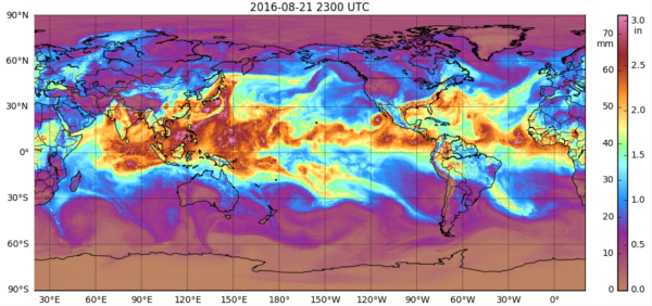
Global “morphed composite” satellite imagery of total precipitable water over both land and sea from August 21-22, created using the newly updated version of MIMIC-TPW. Click for animation.
Full globe TPW coverage opens up a whole new user base.
While the new MIMIC-TPW version is not fully operational yet (it has only been online for a few weeks) the team has already received requests for case study imagery—some of which predate its release, such as a severe flooding event in South Carolina last fall.
“This is very encouraging. It shows you are on the right track,” Wimmers says. “It’s a very good sign that people (forecasters) are that interested in it, and we can start to take it in new directions.”
MIMIC-TPW 2.0 will most likely be operational in the fall of 2016.