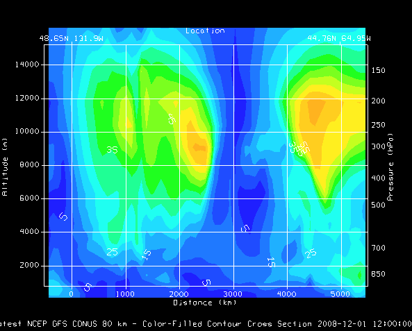
Image 1: Transect View of Wind Speed
The Transect View is a 2-Dimensional display that shows data along a transect line. This type of view can be created through the File->New Display Tab(Window)->Transect Display menu item in the Main Display window.
The left vertical axis shows altitude in meters, the right axis shows pressure levels. The bottom horizontal axis shows distance along the transect. The top horizontal axis shows the latitude and longitude locations of the end points of the transect line drawn in the map display. You can zoom and pan in this display with the normal key and mouse combinations. The transect display will also be duplicated in the Layer Controls tab of the Data Explorer.
To work with a transect display, both a transect panel and a map panel must be open. A transect display can be opened in the Main Display window using the File->New Display Tab(Window)->Transect Display menu item to select one through four transect panels. With the transect panel selected, display any 3D data using one of the Vertical Cross Section display types available in the Displays panel of the Field Selector. This will create a display similar to the image above. The transect line used to create this display will be drawn in the map display panel.
To control the location of the transect, select Transects->Edit in the transect panel. This opens a Transect Drawing Control window that allows for modifying the transect lines in the map display. Using the Create a transect mode, click and drag in the map display to draw the transect. The transect drawn in the transect display will be representative of the most recent transect line you have drawn, assuming the Automatically update transects option is selected in the Controls tab of the Transect Drawing Control window. While multiple transect lines can be drawn in the map display, the transect used for the display in the transect panel will be green in color. When multiple transects are drawn in the map display, you can change which transect is being used for the transect display from the Transects menu of the transect display.
In the Transects tab of the Properties dialog for the Transect View (from View->Properties menu item in the transect display window/tab) you can define a maximum distance to show. Normally, data that lies with the bounding lines that are orthogonal to the transect line is shown in this display. The max distance gives a display radius. Data that lies past this max distance is not displayed.
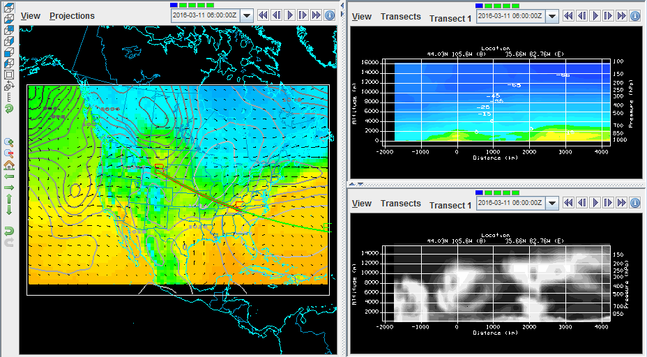
An alternative to having the transect and map panels in different tabs or windows is to use one tab that contains both panels in one. To access this display, in the Main Display window, use File->New Display Tab(Window)->Misc->Transect and Map, 1 Map and 2 Transects, or 2 Maps and 1 Transect. Below is an example showing the 1 Map and 2 Transects panel configuration: