9.1. Executing the ABI Geo2Grid Test Case
To confirm a successful Geo2Grid installation, follow these instructions to create a set of GOES-16 ABI GeoTIFF files from a single time period.
Unpack the test data as shown in Geo2Grid Test Data and execute the following commands:
cd geo2grid_test/abi
mkdir work
cd work
geo2grid.sh -r abi_l1b -w geotiff --num-workers 8 --progress  -f ../input
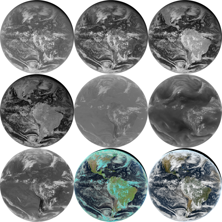
The test case consists of a 7 band subset of Full Disk Level 1B GOES-16 ABI calibrated NetCDF files from 17:45 UTC on 19 December 2018. The dataset includes GOES-16 ABI Bands 1, 2, 3, 5, 7, 9, and 14.
In this test, the Geo2Grid software will create by default as many single band full resolution Full Disk GeoTIFF files as possible, as well as true and natural color images. The true and natural color images are by default atmospherically corrected and spatially sharpened to 500 m resolution in native satellite projection. As it is executing, a progress bar will update, and 8 CPU threads will be used if available. On modern computers, the execution should take around 4-6 minutes.
The output files are large, including the true and natural color images that are greater than 1 GB (21696 lines x 21696 elements).
The software uses ABI Band 1 (.47 micron), Band 2 (.64 micron) and Band 3 (.86 micron) reflectances to create a “Green” Band, which is in turn combined with Bands 1 and 2 to create the true color imagery. The natural color image is created by combining ABI Band 2 (.64 micron), Band 3 (.86 micron) and Band 5 (1.6 micron) reflectances. Both true and natural color images are sharpened to 500 m spatial resolution by using the textural information provided by Band 2 (.64 micron).
If the ABI Geo2Grid processing script runs normally, it will return a status code equal to zero. If the ABI Geo2Grid processing script encounters a fatal error, it will return a non-zero status code.
To verify your output files against the output files created at UW/SSEC, execute the following commands:
cd ..
p2g_compare.sh output work
This script compares the values of all the GeoTIFF files for all ABI Bands found. The output from our test system is shown below.
p2g_compare.sh output work
Comparing 'work/GOES-16_ABI_RadF_C01_20181219_174533_GOES-East.tif' to known valid file 'output/GOES-16_ABI_RadF_C01_20181219_174533_GOES-East.tif'.
0 pixels out of 235358208 pixels are different
Comparing 'work/GOES-16_ABI_RadF_C05_20181219_174533_GOES-East.tif' to known valid file 'output/GOES-16_ABI_RadF_C05_20181219_174533_GOES-East.tif'.
0 pixels out of 235358208 pixels are different
Comparing 'work/GOES-16_ABI_RadF_natural_color_20181219_174533_GOES-East.tif' to known valid file 'output/GOES-16_ABI_RadF_natural_color_20181219_174533_GOES-East.tif'.
0 pixels out of 1882865664 pixels are different
Comparing 'work/GOES-16_ABI_RadF_C07_20181219_174533_GOES-East.tif' to known valid file 'output/GOES-16_ABI_RadF_C07_20181219_174533_GOES-East.tif'.
0 pixels out of 58839552 pixels are different
Comparing 'work/GOES-16_ABI_RadF_C02_20181219_174533_GOES-East.tif' to known valid file 'output/GOES-16_ABI_RadF_C02_20181219_174533_GOES-East.tif'.
0 pixels out of 941432832 pixels are different
Comparing 'work/GOES-16_ABI_RadF_C14_20181219_174533_GOES-East.tif' to known valid file 'output/GOES-16_ABI_RadF_C14_20181219_174533_GOES-East.tif'.
0 pixels out of 58839552 pixels are different
Comparing 'work/GOES-16_ABI_RadF_C03_20181219_174533_GOES-East.tif' to known valid file 'output/GOES-16_ABI_RadF_C03_20181219_174533_GOES-East.tif'.
0 pixels out of 235358208 pixels are different
Comparing 'work/GOES-16_ABI_RadF_C09_20181219_174533_GOES-East.tif' to known valid file 'output/GOES-16_ABI_RadF_C09_20181219_174533_GOES-East.tif'.
0 pixels out of 58839552 pixels are different
Comparing 'work/GOES-16_ABI_RadF_true_color_20181219_174533_GOES-East.tif' to known valid file 'output/GOES-16_ABI_RadF_true_color_20181219_174533_GOES-East.tif'.
0 pixels out of 1882865664 pixels are different
All files passed
SUCCESS
A montage of the 9 output GeoTIFF files (7 single band and 2 RGB images) is displayed below.

Fig. 9.1 GOES-16 ABI montage of images created from the Geo2Grid verification data observed on 19 December 2018 at 17:45 UTC. The images are from top to bottom, left to right, bands 1, 2, 3, 5, 7, 9, 14, natural color and true color.
