 |
||||||||
|
||||||||
2b. Select an Infrared Wavelength |
||||||||
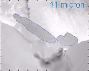
Tracking Icebergs During Nighttime HoursHalf the year the polar regions are in darkness, making detection of icebergs using satellite observations with solar wavelengths useless. Objects on Earth are always emitting infrared energy, which can be used during the day or night. For this reason satellite radiometers measure infrared, or IR, energy. You can use the IR to track icebergs if the temperature contrast between the ice surface and the unfrozen waters provides good contrast. In this exercise, you will select an optimal IR wavelength to identify an iceberg. As with the solar exercise, there is more than one correct answer. Infrared wavelengths that differentiate between water and ice
|
||||||||||||

|
Images of the same geographic region at different infrared wavelengths (range 3.5 - 100 micrometers) |
||
 |
 |
 |
|
The highlighted image aboves uses a wavelength value that provides good contrast between ice and surrounding water during the nighttime. The activity below will help you determine the optimal infrared wavelength value. |
||
Determining an Infrared Wavelength
Use the graph to find a wavelength value with the greatest contrast between ice and ocean surface properties.
Click the forward arrow to continue to
Step 3: Selecting the iceberg.
|
|
Comments? Contact us
This project is sponsored by NASA
|
|