 |
|
|
Remote Sensors and Data Collection - Summary
|
  |
Congratulations!
|
You've just learned some key aspects of satellite sensors.
Here are some important things you should now understand:
- There are many design tradeoffs for remote sensing
instruments which affect the amount and quality of data produced.
- Remote sensing instruments allow us to visualize
characteristics of a target otherwise invisible to the human eye.
- Our knowledge and understanding of the Earth have grown
dramatically since the advent of satellite remote sensing.
|
 |
A Real-Life Example
The table below shows actual characteristics of the GOES I-M
Imager Instrument. Total mission costs for GOES-M were approximately
$350 million for the spacecraft, the instrument payload, launch
services, data analysis, ground operations and mission operations.
| Imager
Instrument Characteristics (GOES I-M) |
Channel
number: |
1 (Visible) |
2 (Shortwave) |
3 (Moisture) |
4 (IR 1) |
5 (IR 2) |
Spectral
Range (um) |
0.55 - 0.75 |
3.80 - 4.00 |
6.50 - 7.00 |
10.20 - 11.20 |
11.50 - 12.50 |
Instantaneous
Field of View
(IFOV) at nadir |
1 km |
4 km |
8 km |
4 km |
4 km |
System
absolute
accuracy |
IR
channels: less than or equal to 1 K
Visible channel: 5% of maximum scene irradiance |
| Imaging rate |
Full
earth disc, less than or equal to 26 minutes |
|
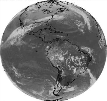
GOES East, Channel 4 image from 22 Jan 2007
|
A 2nd Real-Life Example
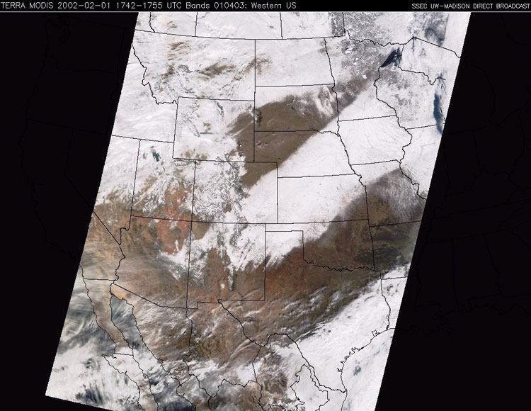
The MODIS image above shows a heavy band of snow across the Midwest.
It also conveys the "swath" east-west limitations of data
produced by a polar orbiting satellite.
The data below shows actual characteristics of the two MODIS
Imager instruments onboard the Terra and Aqua satellites. Total
mission costs for the NASA Terra satellite were approximately $1.3
billion.
| Orbit: |
705 km, 10:30 a.m.
descending node (Terra) or 1:30 p.m. ascending node (Aqua),
sun-synchronous, near-polar, circular |
| Scan
Rate: |
20.3 rpm, cross track |
| Swath
Dimensions: |
2330 km (cross track) by 10
km (along track at nadir) |
| Telescope: |
17.78 cm diam. off-axis,
afocal (collimated), with intermediate field stop |
| Size: |
1.0 x 1.6 x 1.0 m |
| Weight: |
228.7 kg |
| Power: |
162.5 W (single orbit
average) |
| Data
Rate: |
10.6 Mbps (peak daytime);
6.1 Mbps (orbital average) |
| Quantization: |
12 bits |
| Spatial
Resolution: |
250 m (bands 1-2)
500 m (bands 3-7)
1000 m (bands 8-36) |
| Design
Life: |
6 years |
| Primary
Use |
Band |
Bandwidth1 |
Spectral
Radiance2 |
Required
SNR3 |
Land/Cloud/Aerosols
Boundaries |
1 |
620 - 670 |
21.8 |
128 |
| 2 |
841 - 876 |
24.7 |
201 |
Land/Cloud/Aerosols
Properties |
3 |
459 - 479 |
35.3 |
243 |
| 4 |
545 - 565 |
29.0 |
228 |
| 5 |
1230 - 1250 |
5.4 |
74 |
| 6 |
1628 - 1652 |
7.3 |
275 |
| 7 |
2105 - 2155 |
1.0 |
110 |
Ocean
Color/
Phytoplankton/
Biogeochemistry |
8 |
405 - 420 |
44.9 |
880 |
| 9 |
438 - 448 |
41.9 |
838 |
| 10 |
483 - 493 |
32.1 |
802 |
| 11 |
526 - 536 |
27.9 |
754 |
| 12 |
546 - 556 |
21.0 |
750 |
| 13 |
662 - 672 |
9.5 |
910 |
| 14 |
673 - 683 |
8.7 |
1087 |
| 15 |
743 - 753 |
10.2 |
586 |
| 16 |
862 - 877 |
6.2 |
516 |
Atmospheric
Water Vapor |
17 |
890 - 920 |
10.0 |
167 |
| 18 |
931 - 941 |
3.6 |
57 |
| 19 |
915 - 965 |
15.0 |
250 |
|
| Primary Use |
Band |
Bandwidth1 |
Spectral
Radiance2 |
Required
NE[delta]T(K)4 |
Surface/Cloud
Temperature |
20 |
3.660 - 3.840 |
0.45(300K) |
0.05 |
| 21 |
3.929 - 3.989 |
2.38(335K) |
2.00 |
| 22 |
3.929 - 3.989 |
0.67(300K) |
0.07 |
| 23 |
4.020 - 4.080 |
0.79(300K) |
0.07 |
Atmospheric
Temperature |
24 |
4.433 - 4.498 |
0.17(250K) |
0.25 |
| 25 |
4.482 - 4.549 |
0.59(275K) |
0.25 |
Cirrus
Clouds
Water Vapor |
26 |
1.360 - 1.390 |
6.00 |
150(SNR) |
| 27 |
6.535 - 6.895 |
1.16(240K) |
0.25 |
| 28 |
7.175 - 7.475 |
2.18(250K) |
0.25 |
| Cloud Properties |
29 |
8.400 - 8.700 |
9.58(300K) |
0.05 |
| Ozone |
30 |
9.580 - 9.880 |
3.69(250K) |
0.25 |
Surface/Cloud
Temperature |
31 |
10.780 - 11.280 |
9.55(300K) |
0.05 |
| 32 |
11.770 - 12.270 |
8.94(300K) |
0.05 |
Cloud Top
Altitude |
33 |
13.185 - 13.485 |
4.52(260K) |
0.25 |
| 34 |
13.485 - 13.785 |
3.76(250K) |
0.25 |
| 35 |
13.785 - 14.085 |
3.11(240K) |
0.25 |
| 36 |
14.085 - 14.385 |
2.08(220K) |
0.35 |
|
1
Bands 1 to 19 are in nm; Bands 20 to 36 are in µm
2 Spectral Radiance values are (W/m2
-µm-sr)
3 SNR = Signal-to-noise ratio
4 NE(delta)T = Noise-equivalent
temperature difference
Note: Performance goal is 30-40% better than required
|
Further Investigation
|
The links in the box at right will take you to web sites with
topics relevant to the content in this module.
|
Sites with related information
|
|