|
| Weighting functions for VAS channels |
Space Science and Engineering Center, University of Wisconsin
Version 1.03
Compiled by
Francis Bretherton and Don Wylie
June 26, 1998
Table
of Contents
| 1. Science Objectives | 6. Algorithms | 7. Quality Assurance | ||
| 2. Glossary | 6.1 VAS Observed Radiances | 8. Dataset Contents | ||
| 3. Introduction toVAS | 6.2 Visible Radiances | 9. Product Description | ||
| 4. Calibration | 6.3 Cloud Mask | 10. List of Symbols | ||
| 5. VAS Archive | 6.4 Clear Sky Radiances | 11. Collection Metadata | ||
| 6.5 Atmospheric Profiles | 12. References | |||
| 6.6 Cloud Analysis | 13. Acknowledgements | |||
| Science Evaluations | ||||
This data set makes available, in summary form, a 7 day sample during May 1988 of the previously inaccessible archived holdings of VAS dwell-soundings from the U.S. Geostationary Orbiting Environmental Satellites (GOES). The sample is Phase 1 of the Project "Radiances and Cloud Analyses from GOES Dwell Soundings" at the University of Wisconsin, Space Science and Engineering Center.
The VAS observations provide unique constraints on the distribution of water vapor and related cloudiness in the middle and upper troposphere throughout the diurnal cycle over the continental U.S. for the period 1981-1996, as well as measures of surface brightness temperature, and of the horizontal distribution of temperature in thick vertical layers. They provide an important quantitative record of variations over this period in atmospheric properties from hour to hour up to time-scales of years, which, because it has been inaccessible, has not so far been incorporated any systematic manner into our corpus of understanding of weather and climate. Because the dwell-sounding data are confined to the infrared wavelengths, available information about the lower troposphere is less specific and is not emphasized in this summary. However, to enable complementary estimates of daily fluctuations in the absorption of solar energy at the Earth surface, the visible reflectance measured approximately concurrently by the GOES imager is also included in the summary, at a horizontal resolution of about 120 km. A novel feature of this data set is the provision of situation-dependent estimates of uncertainty for the derived variables. These are intended to facilitate assimilation into and comparison with dynamical models and to enable statistical studies of potential bias in climatologies derived from the data set.
The target user for this prototype data set is a research scientist who is engaged in the next generation of re-analysis of weather data including both climate and forecast applications, and who is is equipped to handle the direct assimilation of radiances in addition to radiosondes and other conventional data into an atmospheric General Circulation Model (GCM). Another major target group of users consists of Global Climate Model developers seeking validation and statistical evaluation for alternative model algorithms which control the simulated relationship between cloudiness and water vapor for various seasons and times of day. Other possible applications include a variant of the GOES Precipitation Index (GPI; Arkin, 1997). Using the CO2 channels to report more reliably the area of thick as opposed to thin cirrus, a more refined correlation should be obtainable over the U.S. with rain-gage data, enhancing possible uses of the GPI as a surrogate for direct measurements convective rainfall. Another potential application of the dataset is in broad scale estimates of potential evapotranspiration from the land surface.
To facilitate assimilation and other applications of what, in raw form, is a large and unwieldy dataset, the data products are statistical summaries relevant to a grid of squares bounded by circles of latitude and longitude 1 degree apart over the continental U.S. and neighboring ocean, at times of day which correspond to the available observations, which average every 90 minutes for 1987-88. Because of exigencies in the observing schedules and imperfections in the archive, there are inhomogeneities and some gaps in the coverage at different temporal epochs, particularly in the early years, and the full complement of channels is often not available. Each grid area-time cell is associated with a fixed suite of derived variables, specifically the average radiance for each available VAS channel, and estimates of the channel radiances for clear sky, the effective cloud fraction, cloud pressure level and radiating temperatures, for high, middle and low cloud, together with measures of uncertainty for each variable. The visible radiance from a contemporary VISSR image averaged over a cell is included without further interpretation. This suite of variables has been chosen to convey for the target users as much of the useful information contained within the original data set as possible, consistent with a substantial reduction in the original data volume to a design goal of a few GByte/year of record. For many purposes such as documenting the diurnal cycle of the relationship between synoptic scale water vapor and cloudiness at various levels, it will be appropriate to substantially further reduce the data volume by inferring secondary climatologies. However, the specific implementation is left to the user communities concerned.
It should be understood that, around each nominal time, the actual measurements were spread over approximately 1/2 hour, and that, depending on location, the values reported for each grid square are derived between 36 and 240 raw pixels with a nominal resolution of 8 km. Depending on the channel, either the whole or approximately half the area of the grid square is actually sampled each nominal time. It is anticipated that, within the statistical uncertainties inherent in the summarization, users will interpolate to their grid of choice, provided it is of comparable or coarser resolution.
Apart from the cloud information, full and accurate interpretation of these cell radiances requires comparison, channel by channel, with the results of a directional forward calculation starting from user supplied vertical profiles of temperature and moisture, including the temperature and emissivity of the underlying surface, and concentrations of other absorbing gases such as CO2 and ozone. Where discrepancies with the observed radiances are found, sensitivity studies may be needed to establish probable cause. A reference Fortran code is supplied to enable such forward calculations under clear sky conditions with what is believed to be sufficient accuracy. Comparisons with some state of the art line-by line calculations are also provided. If users prefer their own code, results may be compared with this reference. However, some rough guidance about the normal information content of the various channels is given in the section Introduction to VAS below, which may provide a crude substitute for extensive sensitivity calculations. In particular, atmospheric temperatures may usefully be discussed using only channels 2-5 and 8.
The design philosophy for this product has been to provide for the target user groups as much useful scientific information as possible from the original data, consistent with a manageable product volume, while minimizing extraneous modeling assumptions. Because cloud models play a central role in the interpretation of the raw radiances, the algorithms are inevitably non-linear and complex, with several tunable parameters. Supplemental variables have been included in the output to enable evaluation of the sensitivity of the results to the values of these parameters, and to provide situation dependent estimates of uncertainty for all inferred atmospheric variables. A central issue is how to summarize in an objective manner what can reasonably be inferred from a full-resolution satellite image to a spatial scale commensurate with a general circulation model. Spatial averaging interacts with non-linearity in ways which depend on the sub-grid scale statistical structure of the cloud fields. Modeling simulations of the workings of the algorithm for different assumptions about such structure, coupled to statistical analysis of a large sample of cases covering a wide range of meteorological conditions, are probably necessary to elucidate the true bias and probable error in these results. However, such evaluations are feasible only once the data are readily accessible. This sample product is a first step in such a scientific evaluation.
2. Glossary
VISSR: Visible Infrared Spin Scanning Radiometer.
GOES/VAS: Geostationary Orbiting Satellite System/VISSR Atmospheric Sounder.
Grid: A regular array of Earth located data. Here the standard grid refers to 1 degree squares of latitude and longitude, bounded by 50.5 N, 130.5 W and 24.5 N, 39.5 W. It covers the continental U.S. and adjacent ocean.
Cell: The unit of reporting, which is a grid square at a given nominal date and time. Products are reported for uniformly space grid of cells sized 1 degree latitude by 1 degree longitude.
Pixel: An element of an electronic image of a scene. Also the approximate spatial area sampled by an individual data value from a satellite data stream. For GOES/VAS, pixels are nominally 8 km x 8 km at zenith, but increase in size with increasing values of the angle {ASaZ} between the line of sight to the satellite and the local zenith at the point of emission or reflection. In practice the areas sampled by neighboring pixels may overlap or have gaps between them, and a single data value should be considered merely representative of the neighborhood. Information from individual pixels within a cell is averaged before reporting.
Channel: The data stream corresponding to a particular narrow band of wavenumbers. GOES/VAS has 12 channels, detailed in Table 1, which are designed to maximize the useful information about the state of the atmosphere. Sequential scans of the same line of pixels with different channel filters are completed within a few seconds to provide 12 effectively simultaneous views of the same earth scene. The visible channel at the same nominal date-time is scanned separately within 30 minutes.
Missing data: A gap in the ability to derive a reliable product, usually because the requisite observations were not made because of other operational priorities, or because they cannot be recovered from the archive, or because of excessively noisy or unreliably calibrated data. It is designated in the product fields by the value -1.
Radiance (directional): The radiant energy per unit area, per unit solid angle and per unit wavenumber, incident on the telescope of a satellite after emission or reflection from the earth or its atmosphere. This radiance depends on {ASaZ}. For reflected solar radiation it depends also on the solar zenith angle {ASoZ}, and the solar scattering angle {ASoS}. For emitted radiation it is supposed independent of azimuth.
Clear sky radiance: The directional radiance that would be emitted from a cloud free area. It is assumed to be adequately calculable using radiative transfer theory from an atmospheric profile expressing temperature, humidity, and ozone for a cell as functions of pressure, with a black underlying surface. The clear sky radiances in all channels are estimated for each cell as the observed average from those pixels within the square which are deemed to be clear, or by interpolation from surrounding squares. Clear sky is determined by the cloud mask.
Channel cloud forcing: The effect of clouds on the directional radiance in a given channel. Operationally, it is the difference between the observed radiance in a cell and the estimated clear sky radiance. The term cloud forcing (unqualified) describes the same difference for broadband fluxes of radiant energy .
Brightness temperature: The temperature at which a black body would emit radiance {RAn} corresponding to a particular satellite channel (see Table 1). For the GOES-VAS channels
{RAn} = {c1}*{kn}^3 / (exp({c2}*{kn}/ {Ta}) -1.) mW m^-2 steradian^-1 cm^-1,
where {Ta} is the brightness temperature in degrees Kelvin, {kn}, n = 1, ...,12 is the central wavenumber in cm^-1 for channel n (see Table 1), {c1} = 1.19107 10^-5 mW / (m^2 *steradian*cm^-4), and {c2} = 1.43884 K cm.
Cloud level temperature: The brightness temperature that would be associated with the upward radiation from a layer of cloud if the cloud were opaque and the cloud fraction were 100%. It corresponds roughly to the temperature of the air at a level within the cloud above which the emission optical depth is unity. This temperature is assumed to be the same as that of the surrounding clear sky elsewhere in the cell at the same pressure. Depending on the concentration and absorptive properties of cloud particles, it is typically somewhat warmer than the temperature at the physical cloud top.
Cloud pressure level: The pressure in a cell profile which corresponds to the cloud level temperature.
High Cloud: Cloud with top above 440 mb. Dense or solid high cloud has effective cloud fraction for a pixel of at least 96% .
Middle Cloud: Cloud with top between 440 mb and 680 mb.
Low Cloud: Cloud with top below 680 mb.
Effective cloud fraction: The fractional area of opaque cloud which, radiating as a black body at the cloud level temperature, would account for the channel 8 cloud forcing for those pixels within the cell which are not reporting the presence of cloud in a higher category. The transmittance for such pixels is unity minus the effective cloud fraction. This relationship between transmittance and effective cloud fraction still holds for thin clouds with no discernible gaps. However, the interpretation in terms of physical cloud fraction is more complex.
Cloud mask: A determination from the satellite data set of which individual pixels within a scene are probably clear sky, as opposed to partially or completely contaminated by cloud. Since clear sky is itself a relative term, this determination is somewhat arbitrary and is subject to errors of both exclusion and inclusion. Systematic errors in the cloud mask will be reflected to some extent in the reported clear sky radiances for a cell, and hence in the inferred channel cloud forcing and in the cloud analysis, and users should be sensitive to this possibility.
Base temperature: An intermediate product in determining the cloud mask, representative of the distribution over different, apparently clear, areas within a cell of the temperature of the underlying land or water surface.
Probable error: There is no absolute standard for measuring the accuracy of the reported variables in this product. However, internal consistency checks do permit assigning levels of confidence to individual inferences and groups of inferences. Such levels of confidence change with varying meteorological conditions and associated cloud fields, and the various fields {...UNC} are a systematic, though somewhat qualitative, measure of such uncertainty.
Granule: A unit of the data product defined for a particular date and nominal time. Physically, for this prototype a granule consists of 3 files with the same file name but extensions .hdf, .odl, and .html respectively.
Product Class: A classification of a granule based upon the VAS channels that were available as input data. Possible values are "A", "S", or "C". "A" implies All (channels 1 - 12); "S" implies Standard (at least 2, 3, 4, 5, 7, 8, 9,10 but not "A") ; and "C" implies Cloud Analysis (at least 3, 4, 5, 8 but not "S" or "A"). In each case, available soundings at the nominal time must cover at least 25 degrees of latitude within the standard grid, otherwise the granule is not reported. The scientific value of granules in each class is discussed in the Introduction to VAS below
Collection: A collection of similar granules together with accompanying descriptive documentation and searchable metadata. The collection metadata and documentation, including this User Guide, are an integral part of the product set.
Product Set: The collection, comprising the contents of the goes_vas_product_set directory, which is submitted to NASA for the management by EOSDIS.
Key properties of the VAS radiometric channels involved in the dwellsondes are summarized in Table 1. These are closely similar, but not identical, to a subset of the channels on the High Resolution Infrared Sounder (HIRS) instrument on NOAA polar orbiting spacecraft. A full description and evaluation of the instrument is in Montgomery and Uccellini (1985), to which users are referred for authoritative details. The term dwell-sounding arises because the sensor scans lines approximately parallel to circles of latitude as the GOES spacecraft spins in space 100 times every minute. In imaging mode, the scan line is stepped to a new latitude each revolution, whereas in dwell sounding mode lines are repeated to enhance the signal to noise, and to permit sensing through different channel filters. The fraction of total observing time devoted to dwell soundings as opposed to imaging, and hence the coverage of the former, has varied from day to day according to operational requirements. The 11 um window channel, channel 8, and the 6.7 um water vapor channel, channel 10, are used in both modes.
n |
1 | 2 | 3 | 4 | 5 | 6 | 7 | 8 | 9 | 10 | 11 | 12 |
{kn} |
678.7 | 690.6 | 701.6 | 713.6 | 750.6 | 2210.0 | 790.0 | 895.0 | 1377.0 |
1487.0 | 2250.0 | 2535.0 |
Purpose |
temp | temp | temp | temp | temp | temp, cloud |
moist | surf | moist |
moist | temp, cloud |
surf |
Absorb |
CO2 | CO2 | CO2 | CO2 | CO2 | N2O | H2O | H2O | H2O |
H2O | N2O, CO2 |
H2O |
Other |
O3 | O3 | O3 | O3 | O3 | sun | CO2, dust |
CO2, dust |
CO2 |
- |
sun | sun. dust |
n: Channel number
{kn}: Central wavenumber in cm^-1
Channel 8 in the 11 um infrared window has the most favorable ratio of signal to noise, and images the surface radiating temperature and any clouds which may be present. In this product, channel 8 is the principal source of information for the cloud mask which attempts to discriminate clear sky from partially or entirely cloudy pixels, regardless of the altitude above the surface at which the cloud occurs. Such discrimination depends, however, on the negative temperature contrast between cloud top and the underlying surface, and is ineffective for fog or cloud with a very low top. Thus "clear sky" should be interpreted as potentially including these two last conditions. In addition, the "window" is somewhat contaminated by absorption lines for water vapor, so that under genuinely clear sky but humid conditions the channel brightness temperature may be several K lower than the true radiating temperature of the underlying surface. Furthermore, over land and to a lesser extent over water, the surface emissivity may be significantly less than unity. No corrections have been applied to allow for these effects.
|
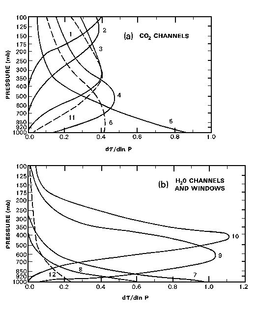
| Weighting functions for VAS channels |
Channels 1, 2, 3, 4, 5 respond to wavelengths in the center, and successively closer to the fringe, of the 15 um CO2 band. As shown in the Figure, under clear sky conditions they are sensitive to radiation from successively deeper layers of the atmosphere, which are cut off below at a given pressure when the corresponding optical depth (opacity) of the CO2 above exceeds about 3. Each channel records the weighted average of the temperature of their layer. Channel 1 is weighted primarily above 200 mb, while channel 5 averages most of the atmosphere, including substantial radiation from the earth surface. However, any tropospheric cloud within the layer intercepts up-welling radiation from warmer air or from any surface below, replacing it by an intensity corresponding to the black body temperature of a level which is generally close to, though below, the cloud top. High cloud thus affects all channels except (usually) channel 1, whereas low cloud only affects channels 5 and, to a lesser extent channel 4. The ratios among the channels of the difference between a pixel radiance and surrounding clear sky (i.e. the channel cloud forcing) thus can provide a signature of cloud pressure level (Smith, 1968). The magnitude of the channel cloud forcing then indicates the average transmissivity of the pixel, here called the effective cloud faction. Cloud reflectance for these channels may be ignored. Note that "cloud level" here is the inferred level at which the surrounding clear sky temperature would give black body radiances in the required ratios; the effective cloud fraction is then the ratio of the channel cloud forcing to what it would have been had the whole area been covered by opaque cloud. If the cloud properties themselves are independent of channel number, which is a good approximation for channels 1-5 but less satisfactory for the remainder, the ratios should be independent of which pair of channels are used to determine them. Significant failure of this requirement indicates either a gross error in the estimated clear sky radiances or, more probably, multiple layers of cloud visible to the satellite within a pixel. In the latter case, the pixel estimate of cloud pressure level will be intermediate, and the reported standard deviation among pixels about the cell average will be increased accordingly.
Channels 9, 10 are located in the main absorption band for water vapor, in order of increasing opacity. Channel 7 includes some water vapor lines within a broader window. Under clear sky conditions, and after allowance in channel 9 for possible transmission from the underlying surface, each channel indicates primarily the relative humidity averaged over a broad range of pressure, with a secondary sensitivity to temperature. This range depends in known ways on the humidity itself, the channel number, and the satellite zenith angle. Precise interpretation requires a sensitivity calculation from a candidate model profile. However, for channel 10 the range almost always lies in the upper troposphere with a cut-off above the earth surface, increasing in height for humid conditions or large zenith angle (Soden & Bretherton, 1993). For channel 9 the range is lower in the atmosphere. The difference in brightness temperature between channels 7 and 8 is normally an indication of total moisture in the lowest levels. With 100% cloud cover the cloud level temperature and pressure replace those of the underlying surface. Thus, if cloud level temperature and effective cloud fraction are well known from other channels, the estimated cloud forcing in these channels may be interpreted in terms of either (1) more detail about the cell wide vertical profile of humidity above the level of the cloud top, or of (2) an association of cloud elements with local increases within the cell of vertically integrated humidity, or of (3) some combination of both possibilities. The choice is left to the user.
Channels 6, 11, 12 are in the 4 um window and are contaminated by reflection of solar radiation during the day. At night for clear sky they provide independent estimates of the radiating temperature of the middle troposphere, lower troposphere, and underlying surface respectively. The window provided by channel 12 is even clearer than channel 8. However, because of the lower emissivity of channel 12 from continuous snow or ice particles versus water or soil, a comparison enables detection of snow cover over land, and or cirrus cloud aloft. The primary effects of cloud at different altitudes are similar to those for the CO2 and water vapor channels. The differences of surface emissivities are smaller than the estimated errors in cloud emissivities from other sources.
The VAS instrument scans approximately along circles of latitude 100 times each minute, with successive selections of channel from a movable filter wheel. In dwellsonde mode, each scan is normally repeated according to an operational schedule to improve the signal to noise, but may be omitted to conserve observing time. The line of pixels is stepped in latitude after completing a pass through the required channels. Channels 8 11 are normally scanned continuously in latitude, but for the remaining channels data swaths nominally 32 km wide alternate with unsampled areas. Coverage of the continental United States normally took two observing periods of some 15 minutes each, separated by time devoted to global images, and the VAS schedule was often modified during periods of severe weather or special requirements.
These operational characteristics show in the data products in various ways. Data coverage extends to less high latitudes around the subsatellite longitude. The range of latitudes actually covered may vary from hour to hour and day to day, though the products are presented only when there is reasonably complete coverage in the central regions of the reporting grid. Product classes reflect the choices of channel priority at different times, and hence imply some grids that are largely or entirely missing data. The number of pixels within a reporting grid area decreases with increasing satellite zenith angle. The channel 8 cloud forcing based on VAS pixels may not be precisely equivalent to that based on channel 8 itself.
It would be presumptuous to ascribe in advance relative values to all the scientific analyses that will be done when data of this type is widely accessible to the research community. Nevertheless, for planning purposes it is necessary to be aware of the opportunities and limitations that are inherent in the data which is actually available. Thus three possible product classes have been defined for the time slice represented by an individual granule. For Product Class A, all the channels discussed above are recorded for the most of the standard grid, enabling studies which relate simulated temperature, ozone, and moisture soundings to observed radiances, including a full cloud analysis, as well as supplementary information by night from the three 3-4 um channels. For the Standard Product Class S, most of the studies for Class A are still appropriate, except the stratospheric temperature is less well determined (channel 1) and the specialist information from the 3-4 um channels may not be present. For Product Class C, it should still be possible to provide a cloud analysis suitable for inclusion in a cloud climatology, but correlative information on water vapor and stratospheric temperature may be absent.
Calibration procedures for VAS data were applied in software before distribution to users or entry into the GOES archive, using pre-launch calibration tables specific to the satellite concerned. These calibrations are thus incorporated through the input data into this data product. The procedures are discussed in Montgomery and Uccelini (1985) and will not be repeated here. If the prelaunch calibrations of stable devices, such as channel filters or the thermistors measuring the temperature of the on board warm body, are inaccurate or have drifted slowly with time, the primary impact is likely to be a small change in the absolute magnitude of the observed radiances and possibly in the ratios among channels, while relative values within a grid or over a few days or weeks are unaffected. Should at some future date such innacuracies be reliably determined from intercomparisons among satellites or by other means, the present products can be corrected after the fact by simple proportional multipliers.
The only known departure from the archived data is the use of improved navigational parameters to specify the position and pointing direction of the satellite. These parameters are derived by McIDAS software in routine poeration at SSEC, using known landmarks in the imagery data stream, coupled to predictive modeling of the satellite orbit and spin dynamics. They routinely yield locations for individual pixels to within 2.5 km. Such accuracy is fully adequate for the purposes of this data product. The temperature clamp on the telescope optics failed on GOES-6. However the telescope temperatures were monitered, and the line by line calibration tables in the archive do enable reliable results to be derived during this period (Menzel, 1995). This epoch does not overlap with the present sample.
The 8 visible sensors on VISSR operated in parallel but were liable to drift independently on all instruments. The resulting striping of the visible image was corrected by operator adjustments of the gain prior to data distribution. The records of such adjustments have been lost. Though the data reported here has been averaged over all 8 channels, the effects of adjustment may not all cancel out, and there remains some uncertainty in the absolute calibration of the visible data. Though it probably indicates correctly the day to day and most month to month variations, longer term changes, particularly between satellites, are not trustworthy. Comparison of sample scenes with AVHRR data by Frouin and Simpson, 1995 gives a general indication of the data quality and approximate absolute calibrations. For the algorithmic relationship between VISSR Counts (CNi) used by Frouin and Simpson and the GVAR radiances reported here, see the section on Visible Radiances below.
5. VAS
Archive
Motivation
This sample product set is a prototype for a similar product covering the entire useful duration of the GOES/VAS observations. In order to evaluate the scientific benefit that might accrue from nearly 20 years of record, a study is reported here to ascertain what raw data is actually available. Because VAS dwell soundings were defined as research rather than operations, the observational schedule changed unpredictably according to the needs of particular campaigns, or to better define the environment of outbreaks of severe storms, or to allow more frequent images of huricanes, etc. In addition, a few observations were lost because of failure in ground communications or in the archive itself.
The Archive Inventory
An inventory of the GOES archive has been maintained throughout its history. The inventory software for the pre-GOES-8 archive was developed and implemented in 1986. It covers the full period of the archive from February 1978 to October 1997. It was designed as an inventory by exception, that is, the primary database is the published data schedule for each day and exceptions to the schedule or data quality which were noted . These notes were made operators who, among other duties, were manually scanning images of the data as they were acquired. Exceptions were frequently ascribed to all data for a day, based on manual observation without verification. The result is an inventory that sometimes overstates the problems when observed, and missed problems if they weren't observed. Fully reliable information requires accessing and scanning every individual tape in the archive, which for reasons of cost has so far never been done.
The Process of Inventory Analysis
The original inventory was first converted to an inventory by inclusion, that is, new files were created that contained a record for every image or dwell sounding that was scheduled. These files were reduced by eliminating all records for images and for soundings that were not recorded on archive tape. In the period 6 March 1982 through 11 January 1996, 137,629 soundings were scheduled and presumably recorded.
The second step in the analysis determined the number of soundings that are estimated to be of good quality. The records with comments that indicated a reduced quality or that the satellite was drifting to a new station were flagged as unacceptable. The latter rule was invoked because data taken during a period when the satellite was drifting from one permanent station to another usually had significantly reduced navigation (geo-location) accuracy. While it is likely that renavigation will recover these data to an acceptable level, it is indeterminate at this time. 116,404 soundings were acceptable based on these criteria.
Step three was the identification of the soundings that fell into one of the three product classes. These product classes are determined by the channels that were available in a particular sounding. Specifically, the "Cloud Analysis" class required that channels 3, 4, 5, 7 and 8 be present. "Standard" further required that channels 2,3,4,5,7,8,9,and 10 be present. And "All" required that all 12 channels be present. These classifications flagged 98,281 soundings as acceptable. Very few (30) "All" soundings were taken prior to the start of mode AAA operations in May 1987. During mode AAA operations till October 1997, 31,322 sounding of class "All" were recorded. Class "Standard" flagged 45,402 distributed uniformly without the archive period with the exception of a lull in 1983 and 1984 and a shift to "All" class soundings between 1987 and 1990. "Cloud Analysis" class soundings were used extensively starting in the latter half of 1992 to the end of the archive period. In all, 21,527 "Cloud Analysis" were recorded.
Normal operation of the satellites required two images of 20 minutes duration in each hour. Therefore it was usually necessary to use two soundings of 10 minutes each to achieve a complete sounding of the continental United States. These soundings were sandwiched between the half-hourly images. The final analysis step determined which soundings met the minimum coverage criteria (maximum latitude > 45 deg. N to minimum latitude < 30 deg. N with at least 20 degrees of latitude range) adequately within the hour window.
The result is the estimated number of granules (46,755) that will be included in the product set. Of these, 8,023 are in class "All", 17,409 of class "Standard" and 21,323 fell into class "Cloud Analysis". No distinction was made for the satellite location (East, West or Central) as the same products will be generated, regardless. However, western grid points will be missing from the products created from GOES-East data, and likewise, eastern grid points will be missing from GOES-West derived products. It is intended to process a number of additional granules which contain potentially useful data but for which the dwell sonde coverage does not reach 20 degrees of latitude.
Summary of Results
Three distinct trends were obvious from the analysis. The frequency of soundings was significantly improved once the VAS instrument became operational in May 1987. The peak for frequent "All" or "Standard" soundings was in the years, 1987 through 1991. The peak for "Cloud Analysis" sounding was from 1991 to the end of operations.
The sporadic nature of sounding operations during 1983 and 1984 hinder a
thorough climatological analysis of the diurnal cycle for the full period
of the archive, but from 1985 on, the inventory analysis identified an average
of 12.2 acceptable soundings per day. This should provide an adequate basis
for climatological analysis.
6. Algorithms
The only product variables which were directly observed are the channel radiances
{RAn}, n=1, ..., 12, and the visible radiance {VISIBLE}. For each sounding,
individual pixels were geolocated using standard McIDAS navigational software
and assigned to the appropriate cell. The reported value is the unweighted
average over the pixels within each cell.
6.2 Visible Radiances
The visible radiances are included here as the grid {VISIBLE} to enable day to day analysis of the solar radiation component of the land surface energy budget, complementing the more detailed information in the infrared. The absolute calibration of this data is suspect, (Frouin and Simpson, 1995 ) but short term relative variations should be well mapped.
The data are stored in the archive as raw VISSR 8-bit brightness (the units referred to by Frouin and Simpson as counts), but are reported here as radiances analogous to the procedure used for GVAR, the successor to the VISSR/VAS instrument on GOES-8 and GOES-9. This is an invariant, reversible transformation, added for convenience in physical interpretation. No radiance units were defined for VISSR. First, as detailed by Chesters, the VISSR brightness is converted to a six-bit value (i.e., divided by 4) and then squared to become a GVAR count, and averaged over each cell. The GVAR count is converted to a radiance (R) per unit wavelength (W/(m^2-sr-um)) using the formula R = (M*counts + b), where the counts are computed above from the VISSR six-bit values. The values of (M, b), which are constants derived experimentally in the factory, are: M=0.5507281 and b=-15.3300. These particular values are valid for detector 8 on GOES 8 -- they are close to the values for each filter on GOES 8 and GOES 9.
After the conversion from VISSR greyscale to GVAR radiance, we noted that for dark images, a negative radiance could result. For example, a 8-bit value of 8 for a VISSR greyscale gives a GVAR count of about 1, yielding a Radiance of -14.76. To avoid this unphysical result, all negative radiances were set to 0. The negative values should not have been a surpise, because, as described by Frouin, zero drift on individual visible sensors is indicated by the non zero brightness of outer space space count at the end of each scan line, resulting in a positive bias in all inferred radiances. On average, the offset b should account for this bias, but for some individual cells it can lead to negative net values. Following Frouin, a more accurate approach to this issue would probably have been to subtract for each observation time the square of the space brightness, averaged over all 8 visible sensors, but that would have involved more extensive data processing and was not done. According to NESDIS tables, GVAR counts of less than 29 have albedos of 0. The VISSR- to-GVAR count formula will yield a value of 29 when the VISSR count is around 41. Thus, VISSR greyscale brightness values of 41 or less yielded equivalent GVAR radiances of 0. Note that this truncated linear conversion from VISSR brightness squared to GVAR radiance makes no allowance for long term sensor drift, or calibration differences among VISSR satellites. Users who care about long-term stability should make empirical adjustments to fit data from aircraft or other satellites, as described by Frouin and Simpson.
A critical step in the algorithms applied to the observed radiances is the cloud mask, which determines which pixels are deemed to be cloud free (i.e. clear sky). Brightness temperatures for channel 8 in the infra red window are used in a multi-step decision process, involving a inference of a base surface radiating temperature {TB} for each cell, and a subsequent comparison with that base of the brightness temperature for each pixel within the cell. If the contrast exceeds a certain cloud mask threshold, the pixel is deemed at least partially cloudy, otherwise it is deemed clear. This operational definition of clear sky conditions is based upon a conceptual model in which:
(1) cloud tops are presumed always to be colder than the land or water surface beneath. Note that in the exceptional case of a strong night-time temperature inversion this may not be true;
(2) there are small areas within an individual cell or within nearby cells which are free of cloud;
(3) the surface radiating temperature reflects primarily the synoptic scale temperature in the deep atmosphere above, upon which is superimposed a diurnal cycle which may be substantial;
(4) for land under clear sky, terrain altitude, surface heat capacity, and vegetation cover cause an additional variability in the surface radiating temperature from pixel to pixel within a cell, but its typical magnitude may be determined empirically; and
(5) over water, pixel to pixel variability within a cell which significantly
exceeds instrument noise is most probably due to contamination by cloud.
This model is applied in a 4 step process, in which each threshold which controls a decision in the algorithm at the cell level is in principle decomposed into a numerical tuning coefficient times an observable variability measure which is averaged over many different but similar cells. A key parameter in assessing the appropriateness of these thresholds is the average variability {TC8ySD} of brightness temperature among clear sky pixels within a typical cell, determined as a statistic during production separately over water (y=WATER) and over land (y=LAND). Though this decomposition does not eliminate the need for tuning based upon the judgement of a scientist who is experienced at interpreting individual images, the conceptual model greatly restricts the range of plausible values for the tunable coefficient and provides a theoretical framework for comparing alternative judgements and systematic analysis of their consequences. The process is initiated using thresholds and acceptable ranges for {TB} which are based solely on the judgement and prior knowledge of a scientist examining sample cases, but in principle these thresholds may be reformulated after the first pass into the product of dimensionless coefficients and variability measures. For this small data sample, the variability measures are objectively determined ,but implementation of the reformulation from the intial statement in physical units into dimensionless terms has been left until a science evaluation of its implications can be completed.
Step 1: The determination of a provisional value for {TB} involves identifying
with a reasonably high degree of confidence any gaps among the clouds, from
which the channel 8 radiance is taken as representative of the whole
cell. For the remaining mixed cells the value of {TB} for each type of surface
is borrowed in Step 3 from adjacent areas following the primary analysis.
This is not known in advance, but is determined estimated during
production from observations of channel 8 radiance {RC8p}under
unequivocally clear sky conditions, and averaged over many different cells
covering a continent and season.
Specifically, members of a 16 x 16 block of pixels centered on the middle
of each cell are grouped into overlapping 2 × 2 arrays. For each such
2 x 2 array, the mean {T8a} and standard deviation {T8aSD} of the channel
8 brightness temperature over the array are calculated. From this set, all
those arrays are rejected for which the standard deviation {T8aSD} exceeds
a threshold which was here kept constant but may be written in the form
{Ca}*{TC8ySD}. {TC8ySD} is a continent- or ocean-wide statistic averaged
over many cells and throughout a season, which measures the variability
of individual pixels about the cell mean under clear sky conditions. It is
a function of time of day and land/water classification, and is derived from
the corresponding measure {RC8ySD} for radiance, for which the daily
contributions to a seasonal average are reported in the granule metadata.
Application of {TC8ySD} to neighboring pixels within an 2x2 array supposes
that the total within cell variability is dominated, or at least
proportional, to that on a spatial scale less than 16 km. {Ca} is a
dimensionless, tunable coefficient that should theoretically lie in the
approximate range [1.0, 2.0]. Based upon expert judgement, suitable
values for the threshold (kept constant throughout this 7 day sample) are
Land: {Ca}*{TC8LANDSD} = 0.45 K
Water: {Ca}*{TC8WATERSD} = 0.3 K
This requirement for spatial coherence (Coakley and Bretherton ) excludes most situations with significant cloud, particularly over water, though it leaves open the possibility of either clear sky or 100% cloud over the array at a uniform cloud level temperature. After rejection of those 2x2 arrays with excessive internal variability, the brightness temperatures of the remaining {Na} arrays associated with a cell form a distribution. These are sorted by brightness, and the coldest member of the warmest 20% is selected, with brightness {T8a20}. All values colder than {T8a20} - {DT8y}are then discarded, where {DT8y} is a fixed threshold. Because of the discard, {T8a20} may no longer be in the warmest 20%, so the selection is repeated until no further discards take place. The remaining {Nb} values of {T8a} are deemed to be probably cloud free, and hence have an internal variability comensurate with {TC8ySD}. {Cb} is another positive, tunable coefficient, of which the function is to eliminate all the arrays which, based upon prior expectation of the within-cell clear sky variability {TC8ySD}, are too cold to be reasonably likely to be cloud free. Expert judgement for the threshold {DT8y} thoughout this 7-day sample is
{DT8LAND} = {CbLAND*{TC8LANDSD} = 2.5 K
{DT8WATER} = {CbWATER}*{TC8WATERSD} = 2.5 K
In theory, plausible values for this threshold should be related to the pixel variability {TC8ySD} about the cell mean under circumstances when the sky was clear, and the coefficients {Cby} should be the same for land and water. However evaluating the consequences of such a change throughout different seasons would require a more extensive sample than the 7 days here available, so the values of {Cby} have not been separately tuned.
If {Nb} is less than {Nbase}=20 , the cell is deemed probably contaminated, and estimates of clear sky conditions are "borrowed" from surrounding cells according to Step 3 . If {Nb} is greater than or equal to {NBase}, the uncertainty in {TBy} by this measure is very low, but there remains the possibility of widespread 100% cloud cover with uniform cloud level temperature, e.g. a dense cumulonimbus anvil or marine stratus. Step 2 is designed to circumscribe this possibility.
Step 2 is a buddy check with other cells for which there is confidence in the assigned value of {TBy}. The values {TBprev} and {TBsubs} for the same location at the same time of day on the previous and subsequent days are examined. The test passes if
EITHER {TBprev} is flagged "confident" and
abs(TBy-TBprev} < {TBuddy}
OR {TBsubs} is flagged
"confident" and abs(TBy-TBsubs} < {TBuddy}
In this case, {TBy} is marked "confident" and Step 3 is omitted. Otherwise, the test fails, the value of {TBy} is replaced temporarily by "missing" and Step 3 is followed.
{TBuddy} is another threshold, set throughout this sample at 2.5 K for both land and water. If the test is passed, the probability is low that the same cell was overcast with essentially the same cloud level temperature on two successive days. Then the quantity
{TByUNC} = min(abs({TBy}-{Tbprev}),abs({TBy}-{TBsubs}))
is used to determine the day to day changes (up to 2.5K) to be expected at that location and season in the value of {TBy}, setting a range on the cloud mask thresholds that are used throughout the subsequent analysis. If the test fails, it merely means that confidence is lacking, and borrowing the value of {TBy} and its uncertainties from surrounding areas is preferred.
Step 3. If, for a particular cell, the selection yielded fewer than {Nbase} pixels or the buddy check "failed", an estimate for {TBy} must be interpolated from cells of the same Land/Water type y which have been flagged "confident". Centered on the cell (0) concerned, a square of side 2*{NS}+1 degrees of latitude and longitude is searched for such cells, starting with {NS} = 1 and increasing {NS} as required till {NI} >= 8 have been found. Weights {W(I)} are then assigned to each I = 1,..., {NI}, inversely proportional to the square of the distance:
{W(I)} = K/((Long(I) - Long(0))^2 + (Lat(I) - Lat(0))^2),
where the constant K is chosen so that
SUM_I = 1 to {NI} {W(I)} = 1.
Then
{TBy(0)} = SUM_I = 1 to {NI} {W(I)}*{TBy(I)}.
Note that the interpolated {TBy} are NOT flagged as "confident", so the order in which cells of the grid are processed is irrelevant. The process ultimately fills all the cells of the grid with and estimate for both y=LAND and y=WATER. For those cells for which {LANDFRACTION} = 0 % or 1 % only the relevant values are used. For cells of mixed type, separate cloud masks are maintained, and the results for each type are prorated at the end. The uncertainty {TByUNC} of interpolated values is discussed in the section on Uncertainty below.
Step 4 is the cloud mask itself. According to the standard mask, an individual pixel in any cell is regarded as cloud free if the base temperature {TBy} exceeds the observed channel 8 brightness temperature {T8p} by less than a threshold {DT8y} = 2.5 K. Because the rationale is similar, this threshold is the identical to already invoked when arriving at direct measurements of {TB}. Otherwise the pixel is regarded as partially cloudy. This mask is applied to every data pixel individually.
The general approach to this cloud mask is based upon that of ISCCP and the MODIS Science Team, though the details are different. A novel feature here is the explicit linking of thresholds to monitored variability of the quantities used in the estimation of the cloud mask. The cutoffs are still to some extent tuned by adjusting the dimensionless multplier according to the judgement of a scientist looking at a range of special cases ("where does it fail?"), but the tuning process is made more explicit and is more accessible to retrospective statistical studies of the sensitivity of the outcome to reasonable adjustments.
If the value of the base temperature was measured and passed the buddy check, the estimated clear sky radiances {RCn} are then the average for each channel {n}over cloud free pixels in the cell . Note that these averages are with respect to pixel radiances, not brightness temperatures. Because of the scanning strategy of the instrument, data pixels for some VAS channels cover only about half the area within each cell, whereas the cloud mask from channel 8 covers the entirety. Where there was not confidence in the determination of cloud free conditions, the value of {TB} has been interpolated from surrounding cells, along with an interpolated uncertainty. The reported {RCn} and {RCnUNC} are then similarly interpolated using the same weights {W(I)}. In addition, standard deviations {RCnSD} among clear sky pixels within a cell are computed for all the "confident" cells. These are reported for each observation time as a statistical distribution over the entire grid area in each LAND, WATER category (ignoring mixed cells). Collectively, these distributions indicate the statistical effects in each channel of instrument noise, of sub grid scale clear sky atmospheric variability, and of variations in the underlying surface, and the channel 8 mean value relates to appropriate thresholds for the cloud mask.
The cloud analysis requires that for each cell a black body radiance be assignable to a hypothetical opaque cloud at arbitrary cloud pressure level. This relationship is used to match the ratios of the observed channel cloud forcing among the CO2 channels with an effective cloud fraction and cloud pressure level. It implies a grid-scale relationship between temperature and pressure known as a sounding, and considerable energy has been devoted to retrieving such soundings from satellite data for the purpose of weather forecasts, including extensive requirements for supplemental radiosonde data and numerical assimlation models. However, the final precision of cloud analysis undertaken here does not warrant more than a simple algorithm which modifies a seasonally averaged sounding derived from radiosondes using local information from the estimated clear sky radiances. Such statistical retrievals inevitably miss details of the actual sounding, but their information content can easily be determined from sensitivity studies, and the errors involved in using them for the cloud analysis seem small compared to those intrinsic to the cloud model itself. The FORTRAN Code for the retrieval routine used here was supplied by H. A. Woolf , and is provided in related documentation.
Also provided is code to perform the forward calculation from a complete atmospheric profile to the directionsal radiances which should be seen by a satellite under clear sky conditions. This may be useful in checking how well the temperature and moisture profiles in a GCM are consistent with the satellite radiances actually observed.
The algorithm for determining cloud pressure level was originally proposed by Smith (1968 ), and has been applied to GOES-VAS data by Wylie and Menzel under the name of "CO2 Slicing". It reports only the uppermost cloud that is exposed to the observing satellite. Inferences or hypotheses about any hidden clouds beneath are left to the user. It assumes that each pixel is partially covered by at most one layer of cloud, for which the black body temperature is equal to that of the surrounding air at cloud pressure level. This cloud is assumed to absorb infra red radiation, but not to reflect it significantly in the channels under consideration. The layer may be regarded as either (1) opaque, but covering only a fraction {CFp} of the area of the pixel, or (2) covering the whole pixel, with partial transmissivity 1 - {CFp}. However, the two parameters, black body temperature {Tp} and effective cloud fraction {CFp}, are all the information that is available on a pixel scale. Cases (1) and (2) are thus extremes of a continuum of indistinguishable interpretations of the observations. Even with this caveat, the model is at best an approximation to real cloud layers, and under some circumstances such as penetrating cumulus, or broken high cloud above low, it may be a poor approximation. The algorithm then generally reports an intermediate value for {Tp}. The neglect of reflection may also involve errors of several percent in the relation between cloud fraction and transmissivity.
Aggregation of pixel level cloud analysis to cell wide statistics is essential
to reduce the data volume and complexity. However, given the non-linearities
and uncertainties in the cloud analysis, is not obvious how to retain the
most useful real information about the clouds actually present in the cell.
The aggregation procedure used here is a compromise, guided by some general
consideration of the target user groups for this dataset, coupled to some
judgements about the systematic impact of idealizations in the cloud model,
and tempered by the conflict between full reporting and the need for simplicity
and transparency.
There are two modifications here of the Wylie and
Menzel approach . The first is an improved cloud mask which
makes no assumptions about the diurnal cycle of surface temperature. The
second is a different method for establishing a cell-wide table of
temperature as a function of pressure which is needed to establish
the radiative effects of hypothetical clouds at different levels. Here the
profile is a statistical retrieval from the reported clear sky radiances
in the CO2 channels in the cell itself, rather than a more detailed first
guess derived from a numerical forecast model. The statistical retrieval
is almost certainly a simplified representation of the true atmospheric profile
in that cell, but the errors introduced into the cloud analysis are small
compared to others associated with the cloudiness model itself. More important,
because of the internal consistency of this approach, it is much easier to
track any systematic errors introduced by this step into the final product.
In addition, the algorithm for calculating forward radiances is invoked
explicitly.
The algorithm for cloud pressure level is applied to each pixel individually
within a background determined by cell wide parameters. It invokes as pixel
input the observed radiances {Rn}for the CO2 channels 2-5 and the window
channel 8 and the cloud mask. As cell input it uses the estimated clear sky
radiances {RCn}, and, in tabular form, the retrieval {Ti} for the cell at
tabular pressures {Pi}, i = 1, ..., 40 , derived from the clear sky radiances
by the FORTRAN subroutine
VASRTW
Step 1 For the cell background, a table of hypothetical radiances {RHn} is
calculated using the Woolf
VASFRWD Model code Version
1 for each of channels n = 3-5 at the appropriate satellite zenith angle,
supposing 100% black cloud at tabular cloud pressure levels {Pi} i=1, ...,40
with no cloud above, using the retrieved temperatures {Ti} as the cloud
temperature. Comparable values for clear sky {RCn} are obtained by setting
the cloud pressure level and temperature equal to the cell mean surface pressure
{PB}, and base temperature {TB} respectively. The difference {RHn}
- {RCn} is then the hypothetical channel cloud forcing for 100% opaque cloud
at the tabular level.
Steps 2-7 are for each pixel within the cell.
Step 2. If the cloud mask indicates "clear", it remains clear and no further
processing is required.
Step 3 This is the default, when the CO2 slicing fails because a measurable
channel cloud forcing appears within the pixel in less than 2 of channels
2-5. {Pp} is then assigned the pressure value corresponding to the interpolation
of the channel 8 pixel brightness temperature {T} into the table
{Ti}. This assignment automatically assumes that {CFp} = 1. In the event
that pixel is only partially covered with cloud, the cloud pressure level
will be systematically over estimated. This default assignment is over-ridden
if step 6 succeeds.
Step 4 For each channel, if the channel cloud forcing {Rn} - {RCn} in negative
or does not exceed 0.05*{RCn} no further processing is done for that channel.
This threshold screens out small values of the denominator in step 5
Step 5 For each pair (n,m), n > m of the remaining CO2 channels 3-5, the ratios {fnm}are computed from
{fnm} = ({Rn}-{RCn})/({Rm}-{RCm})
If no such pair exists, revert to the default. There are 3 possible
ratios that can be calculated from 3 CO2 channels. Any pair may be used in
the final estimate.
Step 6 For each such pair (n,m) the cloud pressure level {Pnm} that would
give the same ratio {fnm} is determined from the table {RHi} of hypothetical
radiances for the cell, by interpolating linearly between tabular values
{Pi} to obtain an exact match. Let {RHn} and {RHm} be the radiances that
correspond to that exact match. IF {fmn} is out of bounds or no match
can be found with {Pnm} lying between the pressure at the Earth surface (i.e.
the value of {P}corresponding to {TB}) and the pressure at the tropopause
(i.e. the value of {P} corresponding the the minimum value of{T} in the profile),
THEN revert to the default.
Step 7 According to the cloud model used for this analysis, the observed
radiances in channels 2-5 should all be consistent within expected error
with a single value of cloud pressure level {Pp} associated with a single
value {CFp} of the cloud fraction. Each value {Pmn} provides an estimate
for {Pp}, and
{CFnm} = ({Rn}-{RCn})/({RHn} - {RCn})
is the corresponding estimate for the cloud fraction for the pixel. Each such estimate uses only the two CO2 channels m, n, and ignores any information in the remaining channels. Where there is a choice among such estimates, it is decided by estimating a total fit residual W for each available pair ({Pnm},{CFnm}), and picking that which has the smallest residual. Given any valid values for ({Pp},{CFp}), interpolation into the tables yields values of {RHk} for all the CO2 channels k = 3,..,5. k= 8 provides an additional term in the total fit. The residual is then
W = SUM_k ({Rk} - {RHk})^2 / {RCkSD}^2,
though for this sample the channels were all given equal weight in terms of brightness temperature ({RCkSD}/{Rk} independent of k) . Because of the way {Pmn} and {CFmn} were are calculated, the terms in this sum corresponding to k = m and k = n are automatically zero, but W is an appropriate measure of the overall consistency. The pair nm which gives the smallest residual, or channel 8 with {CF8}=1, is the one chosen.
Note that channel 8 is not used in the pairs of the CO2 slicing algorithm. This is because channels 2-5 are closely spaced in wavenumber, and the interactions of cloud particles with radiation are essentially the same in each channel, reducing the number of unknowns which have to be determined on a pixel basis. However, including the longer wavelengths associated with channel 8 would cause the cloud analysis to be sensitive to particle size. Given the present limitations on cloud climatologies and microphysical understanding, it seems preferable to reduce complexity by aggregating to the cell level or higher in such a way that users of the data set can themselves interpret any systematic differences between channel 8 observations and what would be expected from the cloud analysis.
Step 8 Aggregation
Once {Pp} has been determined for a pixel in this manner, the pixel is categorized as
High: {Pp} =< 440 mb
Middle: 440 mb < {Pp} =< 680 mb
Low: 680 mb < {Pp}
For each class, the relevant pixels are aggregated separately. The average cloud pressure levels are the unweighted mean over pixels reporting cloud in that category.
IF {CFp} is everywhere zero for class z,THEN {CFz} = 0 and both {Pz} and {PxSD} are reported missing,
ELSE
{Pz} = (SUM_pixels in z {Pp}) / (SUM_pixels_in_z )
{PzSD} = sqrt ((SUM_pixels in z ({Pp} - {Pz})^2) / (SUM_pixels_in_z ))
There is no way of aggregating fractional cloud cover at different heights into a cell average which will accurately reproduce the channel cloud forcing in all the CO2 channels simultaneously. The division into LOW, MIDDLE and HIGH categories, each separately reporting both cloud level temperature and cloud fraction is a compromise between the simple classifications typical of GCM models on a sub-grid scale and the complexities of representing the statistics of real cloud fields. For simplicity, the effective cloud fractions are all related to the cloud forcing in channel 8. Apart from determining the cloud pressure level, the other VAS channels are ignored in the cloud analysis itself. Given the best estimate of cloud level pressure for each individual pixel in a cell, the unweighted arithmetic average is reported as the cell mean {Pz}, z= LOW/MIDDLE/HIGH .
The rules for aggregating effective cloud fraction are somewhat more complicated because of obscuration by higher layers of cloud. Each class reports a non-overlapping area and the transmissivity from the underlying surface to space of that area
The area for each class is that of those pixels which potentially could report cloud of that class, after premption by higher levels, i.e.
{NOBSCLEAR} = Number of VAS pixels in cell reporting clear sky
{NOBSLOW} = {NOBSCLEAR} + Number reporting LOW cloud
{NOBSMIDDLE}= {NOBSLOW} + Number reporting MIDDLE cloud
{NOBSHIGH} = {NOBSMIDDLE } + Number reporting HIGH cloud
Note that all VAS pixels report in one of these classes, so
{NOBSHIGH} = {NOBSTOTAL}
and the remaing areas cloud equally well have been defined by subtraction. Then
{CFz}= ( SUM_pixels_in_z {CFp}*{Pp} ) / {NOBSz}
and the transmissivity of the area {NOBSz} from the underlying surface to space is 1 - {CFz}.
Uncertainty pervades the products reported in this data set. For example, when skies are generally clear, clear sky radiances and cloud forcing may easily be estimated with determinable precision. However, widespread multiple cloud layers make both the clear sky radiances and cloud analyses less reliable. In addition, it is almost impossible to detect widespread ground fog at night from a passive infra-red sensor in space, but failure to do so affects only the reported incidence of very low cloud. In general, the reported measures of probable error for each cell do increase with declining confidence, but should not be interpreted as defining independent random noise.
The combination of sampling and instrument noise associated with individual pixels in a cell is measured by the variables {RCnySD}, n=1,...,12. This may be compared to typical signals in the corresponding channel radiances. The corresponding measure for channel 8 is for convenience reported also as a brightness temperature {TC8ySD}. The statistical distributions of these variables are reported in the html file for each granule.
As explained above under Cloud Mask, for a cell marked "confident" the uncertainty {TByUNC} in the base temperature {TBy} is estimated from the change in {TBy} from the previous and subsequent day at the same time as part of the Buddy Check.
Where insufficient pixels within a cell are judged to be clear, the base temperature {TBy}for that cell must be estimated by interpolation, or "borrowing" from neighboring cells, which inevitably substantially increases its uncertainty by an amount which increases with the distance
{D(I)} = SQRT((Long(I) - Long(0))^2 + (Lat(I) - Lat(0))^2
over which borrowing is taking place. For an individual cell the RMS error may in principle be estimated by the structure function
S{D} = SQRT(average (TBy(I)-TBy(0))^2},
where the average is taken over an ensemble of many cells and meteorological situations for pairs of which the members are flagged confident. True interpolation from {NI} surrounding cells should improve on this probable error, but in the common case of one sided extrapolation S(D) is a better estimate. For this pilot sample, S(D) is not known a priori so in every case of borrowing, the simple expression
TByUNC(0) = 2.0*{NS} K
has been used instead, pending a more refined formulation based on post hoc analysis of the entire sample. Likewise, for other channels the preliminary formulation is
{RCnUNC} = 0.02* {NS}*{RCn}.
Though crude, these measures provide a first order indicator of diminished confidence in the companion fields due to the meteorological circumstances surrounding their estimation .
To clarify the sensitivities involved in the cloud mask, the cloud analysis have also been run with a second, colder, threshold, in which {DT8y} is replaced by {DT8y} - {TByUNC}. This second threshold always reports the same or smaller amounts of cloud, but reflects a realistic range of uncertainty in {TBy} itself. Thus for z = HIGH, MIDDLE or LOW, {CFzUNC} is the difference between the values of {CFz} computed with these thresholds. The differences are substantial for low cloud, but remain relatively small for high cloud, because of the large contrast between such cloud and the underlying surface.
It should be noted that some of the apparent structure of the reported fields for {TByUNC} and {RCnUNC} is an artefact of the method of calculation. In particular, an isolated cell marked confidant will tend to be surrounded by radials at equal increments of latitude and longitude, marking the corners of areas which all rely primarily on data from the same confident cell. Also, the value of {TBLAND} for an ocean cell is pure extrapolation, and should not be taken seriously more than a few cells from the coast. Similar considerations apply to {TBWATER} in the interior of continents, except near lakes of sufficient size and clear sky to enable a "confident" estimate. Extrapolation to fill the region enables simpler coding but in reality these fields are only used in circumstances where they are appropriate.
Related considerations arise in the blending of data within a cell from equally significant measurements by different sensors, or from comparable dwellsondes at somewhat different times. Such distinct data sources are analyzed separately, but used only in those regions for the data is relevant, and averaged in regions of overlap. For certain fields, such as solar scattering angle {ASoS} such blending may give rise to noticeable discontinuities.
The minimum level of detection of cirrus is probably a blackbody cloud signal of about 2.5 K in the channel 8 window. The cloud mask will treat pixels with smaller channel cloud forcing from high cloud as clear. Correlation studies show that this implies a minimum optical depth of 0.1 in visible wavelengths.
Relating the reported effective cloud fraction in the High, Middle and Low categories to a physical cloud fraction requires modeling assumptions about the spatial overlap of different layers, such as their statistical independence and is not a trivial exercise. In addition, it should be noted that when a layer of middle or low cloud is present in the same pixel below cloud in a higher category, such underlying cloud is not reported directly. Instead, the channel 8 cloud forcing is all attributed to the higher cloud, resulting in that higher cloud being reported with a lower cloud top height and larger effective cloud fraction than is physically appropriate. The extreme of this is the default determination of cloud pressure level. Some of the channel cloud forcing attributable to the underlying layer is thus already acounted for, and randomly assigning additional cloud fraction to this layer would be incorrect. Before fitting model cloud climatology models to this data, it would be appropriate to evaluate such biasses using simulations of the cloud analysis algorithm based upon differing assumptions about sub-pixel scale overlap among cloud layers at different levels.
A related issue is the classification of sub-pixel scale penetrating cumulus clouds, for which the assumption of a layer with well defined cloud pressure level and temperature is quite inappropriate. The channel 8 cloud forcing is then a function of viewing angle, because for larger satellite zenith angles {ASaZ} the opaque sides of cumulus towers screen a greater fraction of the horizontal area beneath. A plausible diagnostic of either many pixels containing multi-layer clouds, or of widespread penetrating cumulus within a cell, is a large value for the reported standard deviation of the cell cloud pressure level {PHIGHSD},{PMIDDLESD} or {PLOWSD}.
Table 2 shows the standard deviation {TC8ySD} under clear sky conditions of the pixel radiances in a 1 degree grid square for various channels, averaged over the entire grid and sample. For channels 1-4, and 9-11, the values over land and water are very similar, indicating that the major cause of this variability is either in the atmosphere, or more likely, instrument noise. Channel 8 shows a 35% increase in variability of brightness temperature for land (0.81 K) versus water (0.61 K), consistent with the greater variability over land in surface properties, particularly reflectance and heat capacity. For the other channels which are somewhat sensitive to the underlying surface, the results are intermediate.
Table 2. Mean within cell variability
SD |
TC8 |
RC1 |
RC2 |
RC3 |
RC4 |
RC5 |
RC6 |
RC7 |
RC8 |
RC9 |
RC10 |
RC11 |
RC12 |
LAND |
.81 |
4.99 |
1.50 |
1.40 |
1.16 |
1.33 |
.02 |
1.45 |
1.42 |
.49 |
.21 |
.02 |
.04 |
WATER |
.61 |
5.03 |
1.51 |
1.41 |
1.16 |
1.26 |
.02 |
1.16 |
.97 |
.49 |
.22 |
.02 |
.03 |
UNITS |
K |
R |
R |
R |
R |
R |
R |
R |
R |
R |
R |
R |
R |
K = Kelvin, R= mW m^-2 str^-1 cm^-1
These measures are thus a valuable indicator of noise in the input data, which can be monitored during the production process to flag any deterioration in quality. A related indicator (the tail) is the fraction of cells at any one time for which the observed standard deviation is greater than twice the observed average over the cells reporting. This is particularly valuable for channel 8 brightness temperature as an indicator of possible failures in the cloud mask. Too small a avalue for the base temperature {TBy} for a cell would lead to many partially cloudy pixels being declared cloud free, resulting in an anomalously high pixel to pixel variability and the cell joining the tail. Some such occurrences should be expected by chance as a matter of course, but an unusually large number deserves more detailed examination by a scientist. Histograms of {TC8ySD} are reported in the HTML file for each granule, because such data cannot usefully be fitted into the HDF GRID format. If the tail exceeds a threshold currently set at 7%, a quality assurance flag {QAFLAG} for the granule is set to "YES", triggering an inspection of probable cause by an oversight scientist. Scientific evaluation of such exceptions from a larger sample of granules may be expected to suggest some modification of the {QAFLAG} critieria.
From a user's perspective the Data Product consists of individual data granules, indexed and joined by hypertext links to documentation for the entire collection. For structural view see the Product Description.
The documentation centers on the User Guide (this document), but also includes html browse images for a sample granule, identified by 1988141_2100, i.e. 1988 Julian Day 141, nominal time 2100. It also includes FORTRAN source code enabling computation of clear sky channel radiances from an atmospheric profile of temperature, water vapor and ozone, and conversely. Less obvious are machine searchable text files (in Object Description Language) of keywords to enable the EOSDIS core system to index and advertise this product, and a simplified version of similar information in HTML for easier access by human users.
The data granules are each in three distinct files with the same identifier, but with extensions .html, .hdf, and .odl respectively. The first contains the primary data in the form of 59 HDF grids, and an HDF viewer is required to image them. A different format for an example of the same information is provided in the browse metadata. Some statistical summaries complementing these grids are to be found in the granule .html file. These could not be included in the same HDF file structure for want of suitable software at this time. The product variables and their location are all identified in the list of symbols, along with other names appearing in the equations which describe the algorithms used to derive the products.
Structure
The overall product consists of a tree structured directory containing numerous files comprising a set of items of the types listed below. To preserve links between these items which are necessary for their full utilization, the sub-directory names and file names must be preserved. Strict hdf format has been used where practicable, but because the full ECS toolkit is unavailable, metadata are presented in text and/or html files and are not guaranteed to conform to EOSDIS format standards. Some metadata is text in Object Description Language, identified by the tag .odl .
In the following description of the directory structure and content
files:
the directory names are written in UPPER CASE, even though in the digital
version they are in lower case;
in the file names a bracket [....] means a Class Name which may have
multiple instances in that location. With this exception, every named
file should appear in that directory just once.
GOES_VAS_PRODUCT_SET
index.html
sseclogo.gif
METADATA
index.html
COLLECTION
index.html
user.html
usrguide.html
figure.gif
toc.html
goes_vas.odl
BROWSE
index.html
[GRID].gif
QA
index.html
GOES_VAS_[C]_[DATE]_[TIME].html
RADCODE
index.html
example.txt
sounding.txt
example.out
vasfrwrd.f
vasregtw.dat
vasxtbnd.dat
vasxtdry.dat
vasxtozo.dat
vasxtwco.dat
vasxtwtl.dat
vasxtwts.dat
radiation_code.tar
DATA
index.html
GOES_VAS_[C]_[DATE]_[TIME].hdf
GOES_VAS_[C]_[DATE]_[TIME].odl
GOES_VAS_[C]_[DATE]_[TIME].html
SCIENCE_EVAL
index.html
diurnal.html
std.gif
Here GOES_VAS is the base directory, of which the name may change on transfer to another server. The internal html links use URLs relative to this base, so subdirectory names and file names should NOT be altered.
Contents
Item: "Collection Metadata"
Number of exemplars: 1
Location:
COLLECTION
Consisting of:
4 Files in .html format
1 File in .gif format
1 File in .odl format
subdirectory BROWSE containing :
1 index.html
69 [GRID].gif
subdirectory QA containing:
1 index.html
1 File in .html
format
subdirectory RADCODE containing:
1 index.html
2 files.txt
1 file.f
6 files.dat
Identified by
Filename="index.html"
Filename="user.html"
Filename="toc.html"
Filename="usrguide.html"
Filename="figure.gif"
Filename="GOES_VAS.odl"
Description:
1 User Guide,
ESDTDescriptor file in Object Definition
Language
End item
Item: "Granule"
Number of exemplars: 83
Location: DATA
Consisting of:
1 File in hdf Format
1 File in html format
1 file in .odl format
Identified by:
Filename="GOES_VAS_[C]_[ Date]_[Time].hdf"
Filename="GOES_VAS_[C]_[ Date]_[Time].html"
Filename="GOES_VAS_[C]_[ Date]_[Time].odl"
Description:
Data and metadata corresponding to a particular
data and time.
Contents:
in .hdf 69 GRIDS, corresponding to variables
in the LIST
of SYMBOLS
in .odl Archive metadata using EOSDIS version
B0 terms
in .html Granule wide array data and edite structural
metadata
End item
Item: "Radiation Code"
Number of exemplars: 1
Location: RADCODE
Consisting of:
1 File in html Format
Identified by:
Filename="index.html"
Filename="example.txt"
Filename="sounding.txt"
Filename="
example.out"
Filename="vasfrwrd.f"
Filename="vasregtw.dat"
Filename="vasxtbnd.dat"
Filename="vasxtdry.dat "
Filename="vasxtozo.dat"
Filename="vasxtwco.dat"
Filename="vasxtwtl.dat"
Filename="vasxtwts.dat"
Description:
FORTRAN Source Code, instructions for use
End item
Item: "Quality Assurance Report"
Number of exemplars: 1
Location: QA
Consisting of:
1 File in hdf Format
Identified by:
Filename="GOES_VAS_[C]_[ Date]_[Time].hdf"
Description:
Scientist's report on granule, triggered by
{QAFLAG}=YES
End item
Item: "Science Evaluation"
This item is NOT a deliverable for this project. It is listed
for the benefit of users
Location: SCIENCE_EVAL
Number of exemplars: 1
Consisting of: A collection of text and html files
Identified by: Filename="index.html" + miscellaneous
filenames
Description: Science evaluations contributed by interested
scientists
Updated version: maintained on
URL="http://www.purl.oclc.org/NET/U_WISCONSIN_SSEC/VAS_Product/SCIENCE_EVAL/"
End item
10. List of Symbols
G = Reported as a Grid in each granule
M = Reported as Metadata in each granule
C = Reported as Metadata in collection
E = Used in equations describing algorithms - not reported
| Variable Name | Description | |
| {RAn} | G | Observed Average Radiance for VAS channel n (Cloudy and Clear) n=1,...,12 |
| {RCn} | G | Estimated Clear Sky Radiance for VAS channel n |
| {RCnUNC} | G | Uncertainty in RCn |
| {RCnp} | E | Observed Radiance for a Clear Sky Pixel in channel n |
| {RCnLANDSD} | M | Histogram of Standard Deviation of {RCnp} within cells over Land |
| {RCnWATERSD} | M | Histogram of Standard Deviation of {RCnp} within cells over Water |
| {VISIBLE} | G | Observed Average Radiance (Cloudy and Clear) |
| {ASaZ} | G | Satellite Zenith Angle |
| {ASoZ} | G | Solar Zenith Angle |
| {ASoS} | G | Angle between lines Sun-> Scatter Point -> Satellite |
| {LANDFRACTION} | G | Fraction of Cell Area Covered by Land vs Water |
| {TC8} | G | Brightness Temperature for channel 8 |
| {TC8ySD} | E | Change in brightness temperature coresponding to {RC8ySD} for y=LAND/WATER |
| {TB} | E | Base Temperature |
| {TBLAND} | G | Estimated Base Temperature for Land |
| {TBLANDCHCK} | G | Measured Base temperature for Land |
| {TBLANDUNC} | G | Uncertainty in TBLAND |
| {TBLANDSF} | E | Structure function from {TBLAND} |
| {TBWATER} | G | Estimated Base Temperature for Water |
| {TBWATERCHCK} | G | Measured Base Temperature for Water |
| {TBWATERUNC} | G | Uncertainty in TBWATER |
| {TBWATERSF} | E | Structure function from {TBLAND} |
| {NCLEAR} | G | Number (per Cell) of Totally Clear VAS Pixels |
| {NCLEARUNC} | G | Uncertainty in NCLEAR |
| {NOBSTOTAL} | G | Number (per Cell) of VAS Pixels |
| {Pp} | E | Cloud pressure level for a VAS Pixel |
| {CFnp} | E | Effective Cloud Fraction for a Pixel from channel n |
| {Pzp} | E | Pixel cloud pressure level for class z = LOW, MIDDLE, HIGH |
| {PHIGHp} | E | Pixel cloud pressure level for High Cloud |
| {PHIGH} | G | Cell Average of {PHIGHp} |
| {PHIGHSD} | G | Standard Deviation within cell of {PHIGHp} |
| {Tzp} | E | Pixel cloud level temperature for class z = LOW, MIDDLE, HIGH |
| {THIGH} | G | Blackbody Temperature Corresponding to {PHIGH} |
| {CFHIGHp} | E | Effective Cloud Fraction of a Pixel reporting High Cloud |
| {CFHIGH} | G | Cell Average of {CFHIGHp} |
| {CFHIGHUNC} | G | Uncertainty in CFHIGH |
| {CFHIGHSOLID} | G | Fraction of Dense High Cloud for All VAS Pixels |
| {NOBSMIDDLE} | G | Number (per Cell) of Pixels Potentially Reporting Middle Cloud |
| {PMIDDLE} | G | Cell Average cloud pressure level for Middle Cloud |
| {PMIDDLESD} | G | Pixel to Pixel Standard Deviation of PMIDDLE |
| {TMIDDLE} | G | Blackbody Temperature Corresponding to PMIDDLE |
| {CFMIDDLE} | G | Effective Middle Cloud Fraction for Pixels in NOBSMIDDLE |
| {CFMIDDLEUNC} | G | Uncertainty in CFMIDDLE |
| {NOBSLOW} | G | Number (per Cell) of Pixels Potentially Reporting Low Cloud |
| {PLOW} | G | Cell Average cloud pressure level for Low Cloud |
| {PLOWSD} | G | Pixel to Pixel Standard Deviation of PLOW |
| {TLOW} | G | Blackbody Temperature Corresponding to PLOW |
| {CFLOW} | G | Effective Low Cloud Fraction for Pixels in NOBSLOW |
| {CFLOWUNC} | G | Uncertainty in CFLOW |
| {PRODUCTCLASS} | M | Indicator of available VAS channels |
| {QAFLAG} | M | Quality Assurance Flag YES/NO |
Data File Format
The data files included in this product were produced using Version 1 of the Hierarchical Data Format - Earth Observing System (HDF-EOS) library tools. Documentation describing the file structure and use of the library APIs can be found in the HDF-EOS User's Guide for the ECS Project, June, 1996 (170-TP-005-001). The User guide accompanies the Version 1 library which is available to the user community on the EDHS1 server.
The name of the data file encodes the product name, processing class and temporal identification for all fields within the file. The format for the data file naming convention is as follows:
[NAME]_[CLASS]_[CCYYDDD]_[HHMM].hdf
Where:
NAME = product name ( e.g. GOES_VAS )
CLASS = product class code, where:
        A = all VAS channels (1,2,3,4,5,6,7,8,9,10,11,12)

        S = standard VAS channel set (2,3,4,5,7,8,9,10)

        C = cloud VAS channel set (3,4,5,8)
CCYYDDD = julian date of the data (e.g. 1988001 = 1 Jan, 1988 )
HHMM = nominal time of day for the data (e.g. 0230 = 2:30 GMT)
.hdf = file structure (signifies underlaying HDF file format)
Each data file contains 69 individual fields with their associated structual metadata. These fields (labeled NUMERIC DATA GROUP within each file) represent the EOS specific data structure of type GRID. This datatype is an extension to the underlying HDF framework.
Structural metadata (labeled Vgroup within each file) describing attributes of each grid field are appended to the file during creation. These fields hold tags describing dimensionality, geolocation and other ancillary information which act to define the grid fields. For more information on HDF, please refer the NCSA HDF User's Guide, Version 4.0, University of Illinois, February 1996.
NOTE: Please be aware that INVENTORY level metadata is NOT included within the data files. Due to processing and software limitations, SSEC sought and was granted a exclusion to the granule level metadata requirements under phase 1 of this project. SSEC has produced Object Description Language (ODL) files containing the manditory inventory level metadata for each of the data files within this product set.
Each grid field is composed of uniformily spaced grid points (1 degree in Latitude and Longitude). Grid cells are defined by the geographic region bounded by .5 degree of Latitude and Longitude to either side of the grid point locations. The matrix of grid cells defines the grid field. An individual cell is identified by its row and column rank within the matrix, where grid cell 1,1 is defined as the northwest most cell. Row values increase from north to south and column values increase from west to east.
Depending on the nature of the field, grid point data are stored as either signed 16-bit integers (DFNT_INT16) or signed 32-bit floating point reals (DFNT_FLOAT32). The size and format of the values are defined by the structural metadata fields corresponding to particular grid field. The physical properties of all the fields contained within a file do not support negative values. Therefore, the absolute limits of the individual grid point values are bounded by 0 (zero) and the maximum allowable signed value of the format for a particular grid field. The actual range of possible values for any given field are defined within the inventory level metadata associated with the field.
For those grid points at which a true physical value does not exist or can not be computed, the MISSING DATA CODE (-1) will be assigned.
Each grid field within a file is 26 rows by 91 columns with geographic bounds from 50.5N latitude, 130.5W longitude (grid cell 1,1) to 4.5N latitude, 39.5W longitude (grid cell 26,91). All fields have the same geographic projection defined by the U.S. Geographical Survey General Cartographic Transformation Package (GTCP) with a Projection Id of GEOGRAPHIC and a projection Code Id of 0 (zero). The Geographic projection defines a field of equally spaced grid points in both latitude and longitude. These latitude and longitude bounds represent the upper left corner of grid cell 1,1 and the lower right corner of grid cell 26,91. For futher details on the GCTP projection package, please refer to Section 6.3.4 and Apendix G of the SDP Toolkit Users Guide for ECS Project, May, 1996, (333-CD-003-001).
The table below lists the names of the grid fields contained within each data file, the size (in bits) and format of the grid point values within the grids and a short description of the fields.
| No | Name | Size | Format | Description |
| 1 | RA1 | 32 | float | observed average radiance for VAS channel 1 |
| 2 | RA2 | 32 | float | observed average radiance for VAS channel 2 |
| 3 | RA3 | 32 | float | observed average radiance for VAS channel 3 |
| 4 | RA4 | 32 | float | observed average radiance for VAS channel 4 |
| 5 | RA5 | 32 | float | observed average radiance for VAS channel 5 |
| 6 | RA6 | 32 | float | observed average radiance for VAS channel 6 |
| 7 | RA7 | 32 | float | observed average radiance for VAS channel 7 |
| 8 | RA8 | 32 | float | observed average radiance for VAS channel 8 |
| 9 | RA9 | 32 | float | observed average radiance for VAS channel 9 |
| 10 | RA10 | 32 | float | observed average radiance for VAS channel 10 |
| 11 | RA11 | 32 | float | observed average radiance for VAS channel 11 |
| 12 | RA12 | 32 | float | observed average radiance for VAS channel 12 |
| 13 | RC1 | 32 | float | estimated clear sky radiance for VAS channel 1 |
| 14 | RC2 | 32 | float | estimated clear sky radiance for VAS channel 2 |
| 15 | RC3 | 32 | float | estimated clear sky radiance for VAS channel 3 |
| 16 | RC4 | 32 | float | estimated clear sky radiance for VAS channel 4 |
| 17 | RC5 | 32 | float | estimated clear sky radiance for VAS channel 5 |
| 18 | RC6 | 32 | float | estimated clear sky radiance for VAS channel 6 |
| 19 | RC7 | 32 | float | estimated clear sky radiance for VAS channel 7 |
| 20 | RC8 | 32 | float | estimated clear sky radiance for VAS channel 8 |
| 21 | RC9 | 32 | float | estimated clear sky radiance for VAS channel 9 |
| 22 | RC10 | 32 | float | estimated clear sky radiance for VAS channel 10 |
| 23 | RC11 | 32 | float | estimated clear sky radiance for VAS channel 11 |
| 24 | RC12 | 32 | float | estimated clear sky radiance for VAS channel 12 |
| 25 | RC1UNC | 32 | float | uncertainty in RC1 |
| 26 | RC2UNC | 32 | float | uncertainty in RC2 |
| 27 | RC3UNC | 32 | float | uncertainty in RC3 |
| 28 | RC4UNC | 32 | float | uncertainty in RC4 |
| 29 | RC5UNC | 32 | float | uncertainty in RC5 |
| 30 | RC6UNC | 32 | float | uncertainty in RC6 |
| 31 | RC7UNC | 32 | float | uncertainty in RC7 |
| 32 | RC8UNC | 32 | float | uncertainty in RC8 |
| 33 | RC9UNC | 32 | float | uncertainty in RC9 |
| 34 | RC10UNC | 32 | float | uncertainty in RC10 |
| 35 | RC11UNC | 32 | float | uncertainty in RC11 |
| 36 | RC12UNC | 32 | float | uncertainty in RC12 |
| 37 | VISIBLE | 32 | float | observed average visible radiance |
| 38 | ASaZ | 32 | float | satellite zenith angle |
| 39 | ASoZ | 32 | float | solar zenith angle |
| 40 | ASoS | 32 | float | solar scattering angle |
| 41 | LANDFRACTION | 16 | integer | fraction of cell area covered by land |
| 42 | TC8 | 32 | float | brightness temperature for channel 8 |
| 43 | TBLAND | 32 | float | estimated base temperature for land |
| 44 | TBLANDCHCK | 32 | float | measured base temperature for land |
| 45 | TBLANDUNC | 32 | float | uncertainty in TBLAND |
| 46 | TBWATER | 32 | float | estimated base temperature for water |
| 47 | TBWATERCHCK | 32 | float | measured base temperature for water |
| 48 | TBWATERUNC | 32 | float | uncertainty in TBWATER |
| 49 | NCLEAR | 16 | integer | number of clear VAS pixels per cell |
| 50 | NCLEARUNC | 16 | integer | uncertainty in NCLEAR |
| 51 | NOBSTOTAL | 16 | integer | number of VAS pixels per cell |
| 52 | PHIGH | 16 | integer | cell average cloud pressure level for high cloud |
| 53 | PHIGHSD | 16 | integer | pixel standard deviation for PHIGH |
| 54 | THIGH | 32 | float | blackbody temperature for PHIGH |
| 55 | CFHIGH | 16 | integer | effective high cloud fraction |
| 56 | CFHIGHUNC | 16 | integer | uncertainty in CFHIGH |
| 57 | CFHIGHSOLID | 16 | integer | fraction of dense high cloud |
| 58 | NOBSMIDDLE | 16 | integer | number of pixels potentially reporting middle cloud |
| 59 | PMIDDLE | 16 | integer | cell average cloud pressure level for middle cloud |
| 60 | PMIDDLESD | 16 | integer | pixel standard deviation for PMIDDLE |
| 61 | TMIDDLE | 32 | float | blackbody temperature for PMIDDLE |
| 62 | CFMIDDLE | 16 | integer | effective middle cloud fraction for NOBSMIDDLE |
| 63 | CFMIDDLEUNC | 16 | integer | uncertainty in CFMIDDLE |
| 64 | NOBSLOW | 16 | integer | number of pixels potentially reporting low cloud |
| 65 | PLOW | 16 | integer | cell average cloud pressure level for low cloud |
| 66 | PLOWSD | 16 | integer | pixel standard deviation for PLOW |
| 67 | TLOW | 32 | float | blackbody temperature for PLOW |
| 68 | CFLOW | 16 | integer | effective low cloud fraction for NOBSLOW |
| 69 | CFLOWUNC | 16 | integer | uncertainty in CFLOW |
Abstract of Collection Metadata (Human Readable from GOES_VAS.odl)
CollectionDescription:
ShortName = "GOES_VAS"
LongName = "Radiances and Cloud Analysis from GOES Dwell Soundings"
CollectionDescription = "Observed and estimated clear sky radiance, with uncertainty, at one degree resolution over Continental U.S. for IR sounding channels. Cloud pressure level and fraction."
VersionID = 1.03
LastRevisionDate = "1998-06-26"
SuggestedUsage = "Assimilation of radiances into atmospheric GCMs;
Evaluation of relation between cloudiness, water vapor, and radiation to
space, on seasonal, daily, hourly basis;
Indicators of convective rainfall;
Evapotranspiration from land surface."
VersionDescription = "Demonstration product set covering seven days in May 1988, sampled approximately every 90 mins. Inventory of GOES VAS archives from 1982 to 1995."
CitationforExternalPublication:
Title: "Radiances and Cloud Analysis from GOES Dwell Soundings"
Authors: Bretherton, F. and Wylie, D.
Publisher: Space Science and Engineering Center, University of Wisconsin - Madison
Date: May 1998
Permanent URL: http://www.purl.oclc.org./NET/U_WISCONSIN_SSEC/VAS_Product/EOSDIS/"
CollectionState = "In Work"
MaintenanceandUpdateFrequency = "Unknown"
AccessConstraints = "None"
ProcessingLevelDescription = "GRID"
ProcessingLevelID = "3 (resampled or derived environmental variables)"
TemporalClass = "Hourly_Cloud_Statistics_and_Radiances"
Platform:
PlatformShortName = "GOES-7"
PlatformLongName = "Geostationary Operational Environmental Satellite-7"
PlatformType = "Spacecraft"
SpatialCoverageType = "HORIZ&VERT"
SpatialDomain:
Horizontal - BoundingRectangle
WestBoundingCoordinate = -130.5
NorthBoundingCoordinate = 50.5
EastBoundingCoordinate = -39.5
SouthBoundingCoordinate = 24.5
Vertical - AltitudeSystemDefinition
AltitudeDatumName = "zero pressure (free space)"
AltitudeDistanceUnits = "millibars"
AltitudeEncodingMethod = "Attribute Values"
AltitudeResolution = 1.0
GeographicCoordinateSystem:
LatitudeResolution = 1.00
LongitudeResolution = 1.00
GeographicCoordinateUnits = "Decimal Degrees"
Temporal Domain:
TimeType = "UTC"
DateType = "Julian"
TemporalRangeType = "Periodic"
PrecisionofSeconds = 1
EndsatPresentFlag = "N"
RegularPeriodicGroupDescription:
PeriodName = "Irregular, Hourly"
Period1stDate = "1988-136"
Period1stTime = "01:00:00"
PeriodCycleDurationUnit = "minutes"
PeriodCycleDurationValue = 90.0
PeriodDurationUnit = "minutes"
PeriodDurationValue = 45.0
RangeDateTime
RangeBeginningDate = "1988-136"
RangeBeginningTime = "01:00:00"
RangeEndingDate = "1988-142"
RangeEndingTime = "22:00:00"
Contacts:
ContactPerson - Role = "Producer"
HoursofService = "9AM to 4PM Local Time"
JobPosition = "Director, Space Science and Engineering Center"
ContactName = "Francis Bretherton"
StreetAddress = "1225 West Dayton Street" "Madison, Wisconsin 53706"
Country = "USA"
VoiceTelephoneNumber = "(608) 262-7497"
ElectronicMailAddress = "fbretherton@ssec.wisc.edu"
ContactPerson - Role = "Producer"
HoursofService = "9AM to 4PM Local Time"
JobPosition = "Scientist"
ContactName = "Donald Wylie"
StreetAddress = "1225 West Dayton Street""Madison, Wisconsin 53706"
Country = "USA"
VoiceTelephoneNumber = "(608) 263-7458"
ElectronicMailAddress = "donw@ssec.wisc.edu"
ContactOrganization - Role "Producer"
HoursofService "9AM to 4PM Local Time"
ContactOrganizationName "Space Science and Engineering Center, University of Wisconsin - Madison"
StreetAddress = "1225 West Dayton Street" "Madison, Wisconsin 53706"
Country = "USA"
VoiceTelephoneNumber = "(608) 262-0544"
ElectronicMailAddress = "bobf@ssec.wisc.edu"
Relevant Keywords:
ECSDiscipline="Earth Science"
Field of Study:
Atmosphere, Land Surface, Oceans, Radiance
SubField:
Atmospheric Temperature, Atmospheric Water Vapor, Clouds, Emissivity, Energy
Deposition, Evapotranspiration, Heat Flux, Infrared, Infrared Flux, Infrared
Imagery, Land Surface Temperature, Land Temperature, Liquid Water
Equivalent, Longwave Radiation, Net Radiation, Ocean Heat Budget, Ocean
Temperature, Optical Depth, Optical Thickness, Outgoing Longwave Radiation,
Potential Temperature, Precipitable Water, Precipitation, Precipitation
Amount, Precipitation Rate, Radiation Budget, Radiative Flux, Radiative Forcing,
Reflectance,Shortwave Radiation, Snow, Snow Energy Balance, Snow/Ice
Temperature, Soil Heat Budget, Soil Temperature, Surface Air Temperature,
Temperature Anomalies, Thermal Infrared, Visible Flux, Visible Imagery, Water
Temperature, Water Vapor
Science content:
Atmospheric Emitted Radiation, Bidirectional Reflectance, Brightness Temperature,
Cloud Amount, Cloud Forcing, Cloud Height, Cloud Vertical Distribution, Outgoing
Longwave Radiation, Solar Radiation, Transmittance, Visible Flux, Water
Temperature
Arkin P. A. and P.P.Xie, 1994, "The Gobal Precipitation Climatology Project - 1st Algorithm Intercomparion Project", Bull. Amer. Meteor. Soc., 75, 401-419.
Menzel, W. P., 1993, Private Communication
Montgomery, H.E. and Uccelini L.W.(eds), "VAS Demonstration:(VISSR Atmospheric Sounder) Description and Final Report", NASA Reference Publication 1151, October 1985
Coakley, J.R. and F. P. Bretherton. "Cloud cover from high resolution scanner data: Detecting and allowing for prtially filled fields of view", J. Geophys. Res. , 87, 4917-4932.
Rossow, W.B., A. Walker, and M. Roiter, 1996 revision: International Satellite Cloud Climatology Project (ISCCP) Description of Reduced Resolution Radiance Data. WMO/TD-No. 58. World Meteorological Organization, 163 pp.
Frouin, R.J. and J.J. Simpson, 1995, "Radiometric Calibration of GOES-7 VISSR Solar Channels during the GOES Pathfinder Benchmark Period." , Remote Sens. Environ. 52, 95-115.
Soden, B.J., and F.P. Bretherton, 1993, "Upper Tropospheric Relative Humidity for GOES 6.7 um Channel: Method and Climatolgogy for July 1987", J. Geophys. Res., 98, 16669-16688.
Smith, W.L. 1968, "An improved method for calculating tropospheric temperature and moisture from satellite radiometer measurements." Monthly Weather Review, 96, 387-396
Wylie, D. P., and W. P. Menzel, 1989: Two Years of Cloud Cover Statistics Using VAS, J. of Climate, Vol 2, 380-392
13. Acknowledgements
The authors greatly appreciate numerous contributions from:
Robert Aune, Russ Dengel, Chad Johnson, Barry Hinton, Robert Krauss, Denise Laitsch, Scott Lindstrom, Paul Menzel, Jerrold Robaidek, Hal Woolf, and J.T. Young.
Compiled by:
gvp@ssec.wisc.edu
Latest Revision: June
10,1998
Return to: Top
Project
Page