Robert M Rabin
NOAA/NSSL Warning Research and Development Division
and
Cooperative Institute for Meteorological Satellite Studies
(CIMSS)/UW-Madison
- August 2003 -
To develop applications to enhance utilization of GOES
and polar orbiter satellites in conjunction with Doppler radar & other
data sources for the detection and forecasting of hazardous weather.
2. Summary
of recent research (FY 2003)
* Tracking small-scale thunderstorm top features (overshooting tops, warm wakes, etc)
* Web-based tool for tracking size and intensity
of mesoscale convective systems including time trends of reflectivity,
cloud top temperature, lightning, and environmental parameters (Tom Whittaker,
CIMSS).
* Real-time wind analysis from GOES water vapor band imagery (6.7 microns)
* Multi-sensor algorithm for heavy rain estimates (J.J. Gourley, NSSL,Western Intermountain Storm and Hydrometeorology team).
MOST
11
May 2001
01
June 2001
14
June 2001
Cordell,
OK tornado (09 October 2001)
* Satellite analysis of moisture evolution and fog
formation off California coast
(collaborative
research with the Desert Research Institute: with J. Lewis).
* Evolution of atmospheric moisture/stability from satellite and the onset of the southwestern monsoon with respect to sea surface temperature in the Gulf of California (collaborative research with the Desert Research Institute: with D.Mitchell).
* Remote detection of surface wetness (anticedent precipitation)
from GOES skin temperature heating rates
* Effects of soil moisture on dryline movement and thunderstorm initiation (with Carl Hane)
* Role of lightning in wildfires (with SPC)
* Effects of deforestation (and land use) on daytime
cumulus formation (past and planned)
3. Recent and
Selected Publications
Rabin, R. M., 1989: Diagnosing short term changes in temperature profiles from single Doppler radar data. Mon. Wea. Rev., 117, 1501-1516.
Rabin, R.M., R.J. Doviak, 1989: Meteorological and astronomical influences on radar reflectivity in the convective boundary layer. J. Appl. Meteor., 28, 1226-1235.
Rabin, R.M., S.J.Stadler, P. Wetzel, D.J.Stensrud, M.Gregory, 1990: Observed effects of landscape variability on convective clouds. Bull. Amer. Meteor. Soc., 71, 272-280.
Rabin, R.M., L.A. McMurdie, C.M. Hayden, G.S. Wade, 1991: Monitoring precipitable water and surface wind over the Gulf of Mexico from microwave and VAS satellite imagery. Wea. Forecasting, 6, 227-243.
Rabin, R.M., L.A. McMurdie, C.M. Hayden, G.S. Wade, 1993: Evaluation of the atmospheric water budget following an intense cold-air outbreak over the Gulf of Mexico-Application of a regional forecast model and SSM/I observations. J. Appl. Meteor., 32, 3-16.
Raymond, W.H., R.M. Rabin, G.S. Wade, 1994: Evidence of an agricultural heat island in the lower Mississippi floodplain. Bull. Amer. Meteor. Soc., 71, 1019-1025.
Cutrim, E., D.W. Martin, R.M. Rabin, 1995: Enhancement of cumulus clouds over deforested lands in Amazonia. Bull. Amer. Meteor. Soc., 76, 1801-1805.
Rabin, R.M., D.W. Martin, 1995: Satellite observations of shallow cumulus coverage over the central United States: An exploration of land use impact on cloud cover. J. Geophy. Res.-Atmospheres, 101 (D3), 7149-7155.
Segal, M., R.W. Arritt, C. Clark, R. Rabin, J. Brown, 1995: Scaling evaluation of the effect of surface characteristics on potential for deep convection over uniform terrain. Mon. Wea. Rev., 123, 383-400.
Diak, G.R., R.M. Rabin, K.P. Gallo, C.M. Neale, 1995: Regional-scale comparisons of NDVI, soil moisture indices from surface and microwave data and surface energy budgets evaluated from satellite and in-situ data. Remote Sens. Rev. 12, 355-382.
Maddox, R.A., D.S. Zaras, P.L.MacKeen, J.J. Gourley, R. Rabin, and K.W. Howard, 1999: Echo height measurements with the WSR-88D: use of data from one versus two radars. Weather and Forecasting, 14, 455-460.
Caruso, S.J, R. Rabin, D. Zaras, J. LaDue, 2000: A new look at the McCann study of the enhanced-V signature. 10th Conf. On Satellite Meteorology and Oceanography, Long Beach, CA., 10-14 January, 2000, JP4.14.
Rabin, R.M., B. Burns, C. Collimore, G.R. Diak, W. Raymond, 2000: Relating remotely-sensed vegetation and soil moisture indices to surface energy fluxes in vicinity of an atmospheric dryline. Remote Sens. Rev., 18, 53-83.
Hane, C.E., R.M. Rabin, T.M. Crawford, H.B. Bluestein, M.E. Baldwin, 2001: A case study of severe storm development along a dryline within a synoptically active environment. Part I: Dryline motion and an Eta Model forecast. Mon. Wea. Rev., 129, 2183-2204.
Hane, C.E., R.M. Rabin, T.M. Crawford, H.B. Bluestein, M.E. Baldwin, 2000: A case study of severe storm development along a dryline within a synoptically active environment. Part II: Multiple boundaries and convective initiation. Mon. Wea. Rev., 130, 900-920.
Mitchell, D.L., D. Ivanova, R. M. Rabin, T.J. Brown, K. Redmond, 2002: Gulf of California sea surface temperatures and the North American monsoon: Mechanistic implications from observations. J. Climate, 15, 2261-2281.
Setvák, M., R.M. Rabin, C.A. Doswell III, V. Levizzani, 2003: Satellite observations of convective storm top features in the 1.6 and 3.7/3.9 m spectral bands. Accepted to Atmospheric Research.
Lakshmanan, V., R. Rabin, V. DeBrunner, 2003: Multiscale Storm Identification
and Forecast. Accepted to Atmospheric Research
4. Figures
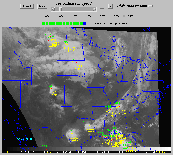
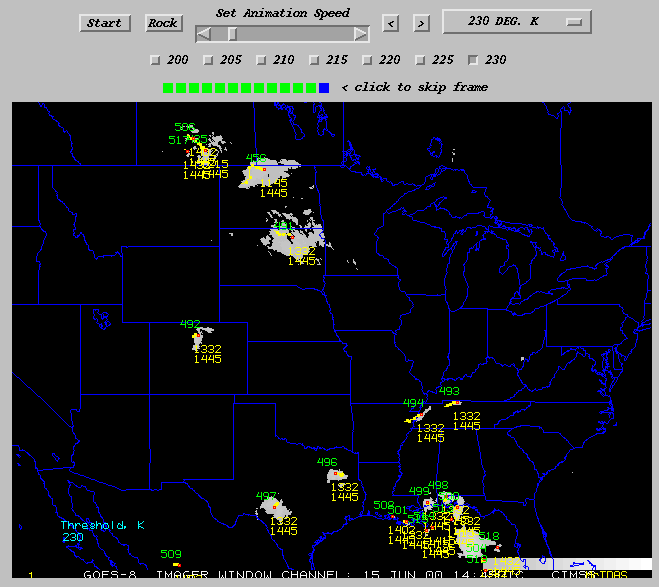
Fig. 1a: Example output from thunderstorm cluster tracking algorithm. Tracks are based on centroid positions for past 3 hours. Cluster number (green) and the beginning and ending time (yellow) are shown. Users can replot tracks using different cloud top temperature thresholds and enhance the image (Fig. 1b) to highlight cloud clusters defined by those thresholds. By successively choosing lower temperature thresholds, it?s possible to isolate and track overshooting tops.
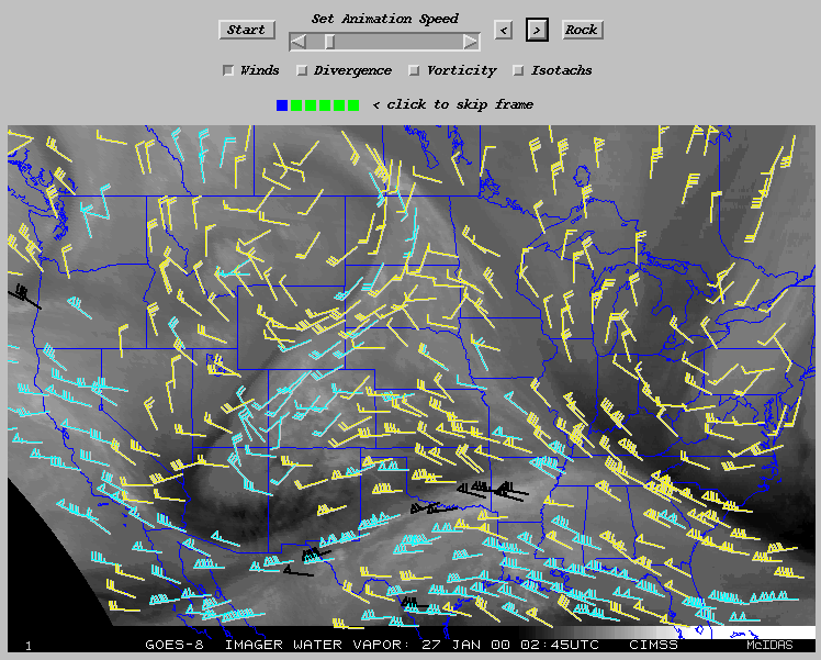
Fig. 2: Example output from real-time satellite winds web page: high density wind vectors from automated feature tracking algorithm. Uses 30 minute GOES water vapor imagery (6.7 micron). Each wind vector is assigned a layer height based on the observed radiance and vertical weighting function (black: 100-250 mb, cyan: 251-350 mb, yellow 351-500 mb).
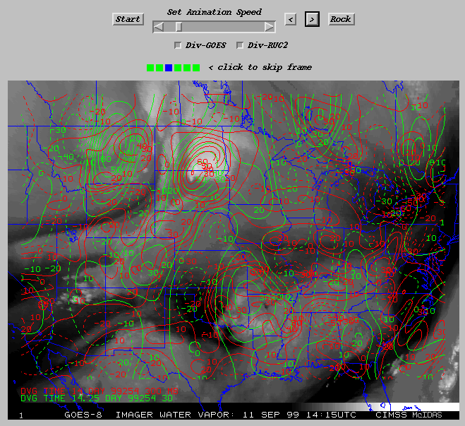
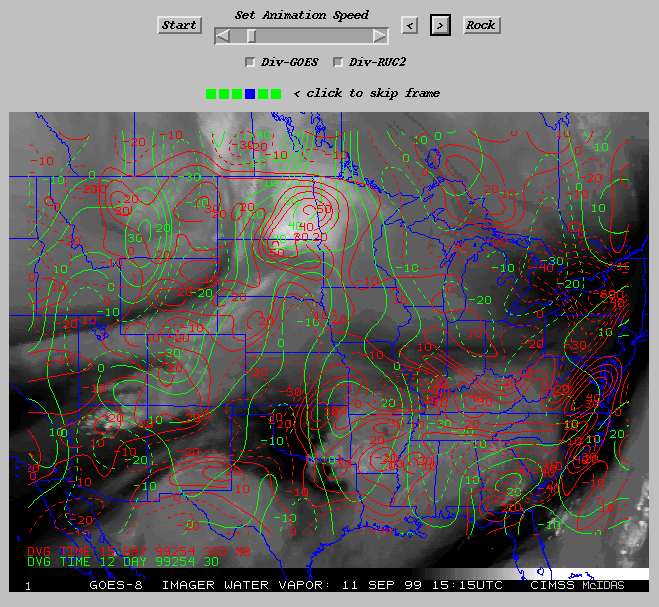
Fig. 3: Example output from real-time satellite winds web page: contours of divergence at 300 mb from an objective analysis which combines winds from the satellite algorithm and a first guess model (NOGAPS) in green, and from the RUC-II analysis in red. Note the divergence (positive values) associated with the convective complexes in the Dakotas and Oklahoma. In general, the RUC-II analysis has smaller-scale structure owing to its high resolution. In some locations, there are also significant differences in the location & magnitude of divergence/convergence centers.
Fig. 4: Same as Fig. 2, except 1 hour later. Note the weakening divergence associated with the decaying convection in eastern Oklahoma. Also, strong convergence is evident behind the system where upper level drying has occurred.
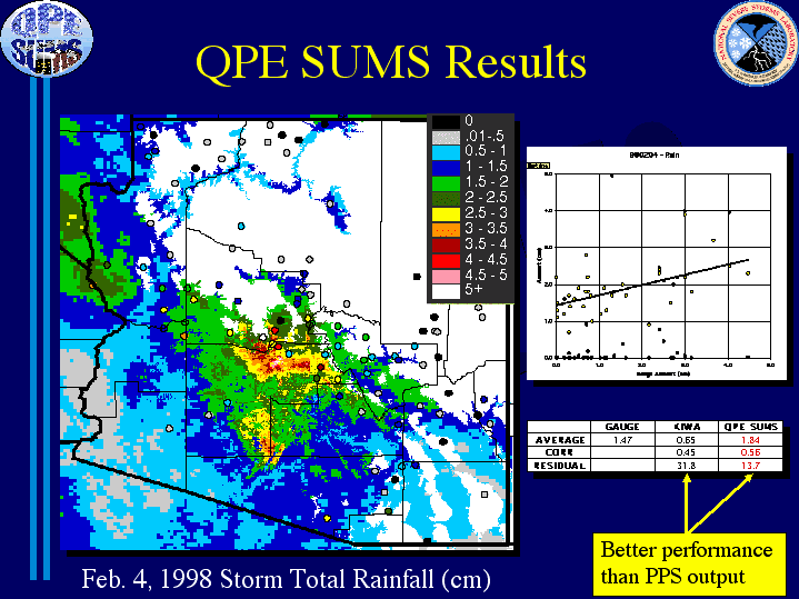
Fig. 5:
Storm total precipitation estimated in Arizona from multisensor 88D/GOES
algorithm (from J.J. Gourley). Image on left shows the spatial distribution
of estimated preciptation and locations of rain gages. Scatterplot at upper
right compares the estimated values with gage measurements. Statistics
shown in the table at lower right indicate significant improvement of the
multisensor technique over radar only estimates.