« Back to "Hurricane Barbara - July 2019"
Hurricane Barbara – 4 July
Posted: July 4, 2019
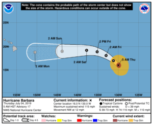
As of the latest public advisory, which was at 0900Z on 4 July (https://www.nhc.noaa.gov/text/refresh/MIATCPEP2+shtml/040837.shtml), while Hurricane Barbara has weakened to have sustained winds of ~120mph (115mph as of 1500Z, https://www.nhc.noaa.gov/text/refresh/MIATCPEP2+shtml/041432.shtml?), it is still a major Category 3 storm on the Saffir-Simpson scale. As with yesterday’s discussion, this discussion will use UTC time rather than HST to alleviate any confusion on dates.
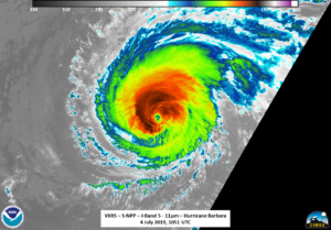
The discussion will first focus on what was seen by the VIIRS imager. At ~1001Z, NOAA-20 got an almost near nadir overpass of Barbara, allowing for the I-05 11um (375m resolution) channel to easily see the nearly symmetrical eye along with the convection encompassing most of the circulation.
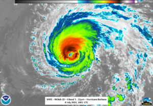
However, if one compares it to yesterday’s imagery, one will see that the eye is not as prominent and looks slightly more ragged.
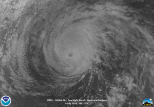
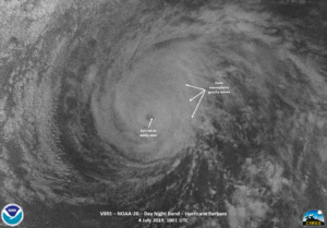
In addition, the DNB imagery from NOAA-20 on 4 July, which was illuminated by airglow, as the waxing crescent moon was only at 4% illumination, did not show as an obvious eye as well, despite the (very) faint mesospheric gravity waves coming off the northeast part of the storm.
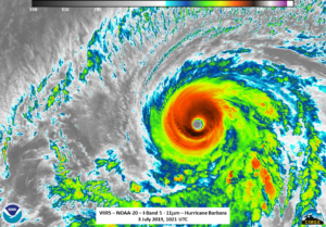
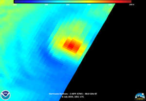
Approximately 50 minutes later, SNPP also observed Barbara, though this time at the edge of the scan. While the storm was lost in the edge of scan noise in the DNB imagery, the IR imagery showed a that the circulation was not completely surrounding the circulation center.
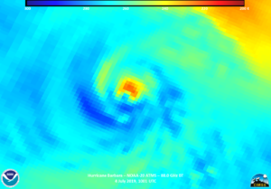
The fact that NOAA-20 provided a near nadir pass also meant that the ATMS instrument was able to observe the inner parts of the storm. The 88.2GHz brightness temperature seemed to indicate that the circulation was not completely surrounding the circulation center.
This is further supported by the observations of the AMSR2 instrument on the GCOM-W1 satellite, which had a decent, edge of scan, pass of Barbara roughly 20 minutes after NOAA-20. In fact, there seems to be a relatively noticeable gap in cold temperatures in the AMSR2 89.0GHz BT on the southwest side of the storm.
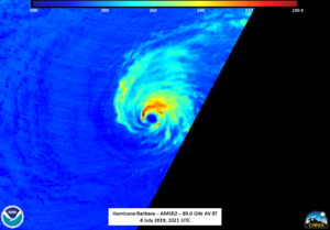

So, while the circulation is still symmetrical in the microwave imagery, the convection does not appear to be symmetrical as the 0900Z forecast discussion mentioned (https://www.nhc.noaa.gov/text/refresh/MIATCDEP2+shtml/040838.shtml). It is important to note that the AMSR2 and ATMS imagery came in after the 0900Z forecast, though it doesn’t appear to have made it in the 1500 forecast discussion either (https://www.nhc.noaa.gov/text/refresh/MIATCDEP2+shtml/041436.shtml). It is interesting to not that the 1500Z forecast discussion mentions increasing southwesterly shear, which is the side of the storm that AMSR2 had lack of cold clouds at ~1021Z.
Because SNPP observed the storm at the edge of scan meant that the ATMS instrument on board SNPP only showed a blob of cold clouds. This shows the need to utilze all satellites in conjunction with one another.
Barbara is forecast to continue to weaken as it goes over cooler waters and looks to currently be a depression as it reaches the CPHC region of responsibility this weekend. One more observation will occur tomorrow before discussions will stop (unless there is a major impact to Hawaii).