« Back to "2019 California Wildfiles"
Kincade Fire on 26 October 2019
Posted: October 26, 2019
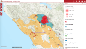
The dangerously fast-moving fire near Geyserville in Sonoma County, reportedly beginning at ~9:24pm on October 24, continues to burn. The media has reported say that PG&E, in a preliminary report to the California Public Utilities Commission, stated that an equipment malfunction occurred minutes before the Kincade Fire started and despite areas around having the power shut off, transmission lines in the area were fully energized. At this time, the official cause of the fire remains under investigation. The blaze has grown in size fueled by the dry vegetation as well as winds of up to 60 miles per hour. This has caused the fire to move at a dangerous rate. As of the 7:00am PDT update on 26 October, CalFire reported that the fire was approximately 25,455 acres in size and 10% contained. There are also over 2000 evacuations including the entire town of Geyserville, CA. According to media reports, as of Saturday morning, there were at least 50 structures destroyed but no reports of any fatalities. In addition, the areas of evacuations have been ordered in Sonoma county. These can be seen on the Sonoma County Incident Map, shown below
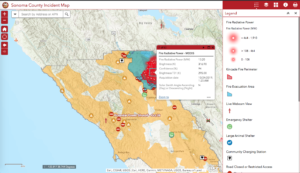
Another thing that can be seen on the Sonoma County maps are the evacuation zones along with the MODIS Fire product fire radiative power, which is an indication of how intense the fire currently is.
For a refresher on how each of the channels can be used, please refer to the previous post on this fire.
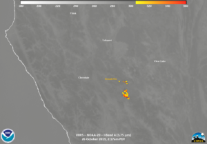
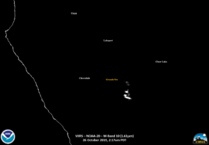
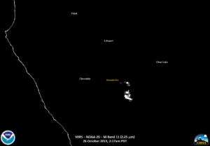
The Kincade Fire was observed by NOAA-20 twice on the edge of the pass and S-NPP once at near nadir. The first observation from NOAA-20 occurred at approximately 2:17am PDT (0917 UTC). It is important to note that because the fire is at elevation, there are some parallax effects due to it being on the edge of the scan. Despite that, several features could be observed. The first is something seen in the IR and NIR bands, shown below, namely that most of the hottest spots of the fire were on the southern flank of the fire
This is where the hottest temperatures in the I04 (3.75μm) channel occurred as well as the largest radiances in the near-infrared M10 (1.6μm) and M12 (2.25μm) channels occurred. This is also where the majority of the detection’s in the VIIRS Active Fire (VAF) Product, as processed by CSPP, occured
Also, because of the intensity of the fire, it could also be seen in the I05 (11μm) channel. This is not unusual, rather it speaks to how intense the fire is.
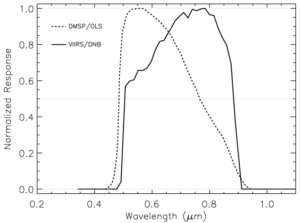
It is interesting to point out what happens in the Day Night Band (DNB). The spectral response function of the Day Night Band, shown below, goes into the shortwave/near infrared part of the spectrum. This means the DNB can see not only emitted light, but thermal energy as well, similar to the M10 (1.6μm) band.
Image from the Visible Infrared Imaging Radiometer Suite (VIIRS) Imagery Environmental Data Record (EDR) User’s Guide, version 1.3
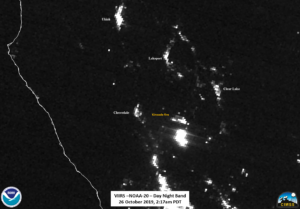
This will result in a “blooming” effect of more intense heat sources, such as intense wildfires, as seen below
Since smoke is relatively optically thin in the IR channels, one cannot rule out the possibility of smoke from the fire causing scattering of the visible light from the fires.
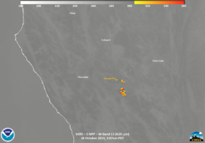
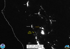
The Suomi-NPP pass ~50 minutes later at ~3:07am PDT (1007 UTC), observed the Kincade fire at near nadir. This limits the parallax effects that may have occurred in the NOAA-20 pass 50 minutes prior. The lower resolution (750m) fire channel, M13 (4.05μm), again showed that the most intense part of the fire was on the southern side.
If you compare to the NOAA-20 pass from ~2:17am PDT you can see that while the location of the fire hasn’t changed, the temperature has.
This could be due to either the fire flaring up or due to parallax effects. In addition to the ability to provide the initial detection of fires, this viewing angle variation from pass to pass in another reason to pair observations from polar and geostationary satellites. This is because the geostationary satellites, in addition to having a high temporal refresh rate, also have a fixed viewing angle of a given location, no matter the time of day. This is something shown below from GOES-17 showing the Kincade fire as it varies over the course of 2-days, from the CIMSS Satellite Blog.
However, because geostationary satellites orbit far away from the Earth, they lack the high-resolution imagery that is provided by polar satellites. Hence the need to utilize both.
As mentioned above, both satellite passes show the same features, including the blooming effect seen in the DNB due a combination of how intense the fire was along with smoke that was likely being produced at the time. This can be seen in the following sliders show the temporal change in the I04 (3.75μm), M11 (2.25μm), Day Night Band and finally the VIIRS Active Fire Product.
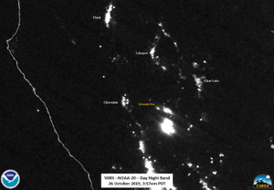
As can be seen in each of the above sliders, various features of the fire remain consistent, but the S-NPP imagery shows a better picture due to it being a near nadir pass. In fact, this can be further emphasized by looking at the second NOAA-20 pass, which occurred at ~3:57am (~1057 UTC). As can be seen by looking at the high resolution I04
Notice how the fire has a noticeable shift as compared to the near nadir S-NPP imagery. This is because, despite the fact that the geolocation is corrected for the terrain, the feature itself is on the edge of the pass. This means like, just as in observations of hurricanes, features become distorted due to parallax. This also affects the imagery from the Day Night Band as well.
The final thing to observe in this imagery is that if you compare the NPP imagery to that of 23 October 2019, it appears that power has been restored to that area, despite the fire being nearby
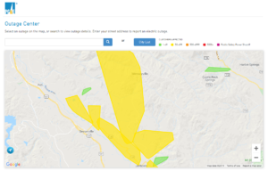
This is consistent with the Pacific Gas and Electric outage website taken at approximately 4:30amPDT this morning,
As was confirmed by PG&E and reported in the media, they are expected to cut off power to 940,000 customers starting at 2pm PDT on 26 October. An interactive map is shown below (link here) and can be viewed in PDF form, which was taken from the PG&E website as was this screenshot, which was taken at 12:21pm PDT.
As of the fire incident update at 7am PDT, CalFire working to mitigate threats to structures as well as construct a control line. However, this is difficult because the fire is burning in remote steep terrain making access to the fire difficult and slow due to limited access to the fire. Approximately 2,090 personnel are assigned as of the 7am update with 10 helicopters working fire suppression.

