« Back to "Hurricane Ian : 27 September 2022 - October 2022"
Hurricane Ian on 27 September 2022
Posted: September 27, 2022
On 19 September 2022, the NHC began tracking a tropical wave to the east of the Windward Islands and was designated Tropical Depression 9 on 23 September 2022, finally becoming Tropical Storm Ian at 0300 UTC on 24 September 2022, per the National Hurricane Center. It intensified to a Category 1 by 0900 UTC on 26 September 2022. The advisory that was just prior to the GCOM-W1 pass at 0656UTC and the NOAA-20 pass at 0734UTC occurred at 0630 UTC, and stated that maximum winds were approximately 115mph, was a low level Category 3 storm. However, an hour later, Ian was a high end Category 3 storm with sustained winds of 125 mph (205 km/h) as it made landfall at 08:30 UTC on September 27 2022 near La Coloma, in Pinar del Río Province, Cuba. This means that Ian was continuing to intensify during the time period that AMSR2 and NOAA-20 observed the storm.
As seen in the high resolution (375m) I05 (11μm) brightness temperature imagery, one can see not only the well defined circulation indicative of a intense hurricane, but several tropospheric gravity waves. Another major feature is that one can see a well defined eye
If you zoom in, one can more clearly see these features even better
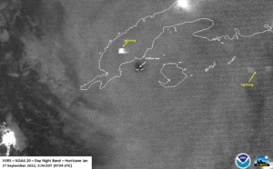
The moon was at Waxing crescent (3% illumination), meaning that the primary source of light is from airglow. As one might expect from an intensifying storm, there were some faint mesospheric gravity waves, though they were further out from the main part of the storm, meaning they were generated prior to the NOAA-20 overpass. In addition, some lighting was observed in the convection surrounding the storm.
What is most interesting is that the well developed eye is easily seen, especially in the zoomed imagery
While VIIRS covers the infrared and visable imagery, it is key to utilize microwave imagery to look at the inner structure of the storm. Both the ATMS on NOAA-20 as well as AMSR2 on GCOM-W1 both showed a well defined circulation, with the convection mostly along the western side of the storm. This is in a similar location as what the I05 band shows for the most intense convection, though there is some discontinuity.
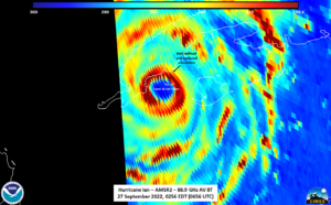
This is likely due to differences in the structure of the storm. AMSR2, which was 30 minutes prior, showed the structure of the storm at higher resolution, clearly showing a well defined circulation with convection completely surrounding it, as seen in the image below.
This is very similar to what ATMS shows for the similar wavelength (i.e. similar part of the atmosphere), though it was slightly rotated, which would be expected from a rotating storm.
The current forecast has Ian continuing to intensify as it approaches the United States, eventually impacting the region near Tampa before impacting the southeast United States potentially making landfall on 28 September 2022.


