Image 1: Point Data Dialog Window
The metadata of this point data must be specified. This can be done in two ways. First, the file can have two extra header lines that defines for McIDAS-V the fields that are within the file and the types of the fields. The only other requirement is that there must be a latitude, longitude and time field in the data. See below.
Secondly, if there are no metadata header lines defined, the Text Point Data Source will show the Metadata GUI described below.
More information about the format of Time and Lat/Lon symbols can be found in the User Preferences' Formats and Data Preferences page.
(index) -> (Time,Latitude,Longitude,Altitude,PSL,GUS,SPD,DIR,TD,T)
Time[fmt="yyyy-MM-dd HH:mm:ss"],Latitude[unit="deg"],Longitude[unit="degrees west"],Altitude[unit="m"],PSL[unit="hPa"],GUS[unit="m.s-1"],SPD[unit="m/s"],DIR[unit="deg"],
TD[unit="celsius"],T[unit="celsius"]
2007-01-07 16:00:00Z,32.9,117.1,145.0,1026.1,NaN,0.0,0.0,-2.8,12.8
2007-01-07 16:00:00Z,48.3,92.5,341.0,1003.7,NaN,1.5,170.0,-2.0,-0.99
2007-01-07 16:00:00Z,36.8,98.7,449.0,1024.0,12.4,9.8,330.0,-3.0,3.0
2007-01-07 16:00:00Z,44.3,121.2,938.0,1030.1,NaN,2.1,110.0,-3.3,-1.7
Note also that the first line's structure is quite rigid -- there must be a variable (e.g., index, recNum) that is the domain parameter; this should map to the range values. The second line defines the formatting and units of the parameters. Unit names should be standard international unit specifications (udunits compatible). A list of valid names can be found here. (A complete description of this format is contained in the VisAD README.text file.)
Also note that "Time", as well as the locations as "Latitude", "Longitude" and "Altitude" must be specified (if needed).
(index) -> (Time,Latitude,Longitude,Altitude,ST(Text),T)
Time[fmt="yyyy-MM-dd HH:mm:ss z"],Latitude[unit="deg"],Longitude[unit="degrees west"],Altitude[unit="m"],ST(Text),T[unit="celsius"]
2007-02-16 11:00:00 MST,32.9,117.1,145.0,CA  ,20.6
Here we have a ST field (State from metars). Its field name is defined as "ST(Text)" and its entry in the second line is the same.
(index) -> (IDN, Latitude, Longitude, Time, WDIR, WSPD, GST)
IDN, Latitude[unit="deg"], Longitude[unit="deg"], Time[fmt="yyyy MM dd HH mm" colspan="5"], WDIR[unit="deg" miss="MM"], WSPD[unit="m/s" miss="MM"], GST[unit="m/s" miss="MM"]
41001 34.68 -72.66 2007 07 17 20 50 210 4.0 6.0
41004 32.5 -79.09 2007 07 17 20 50 210 6.0 MM
41008 31.4 -80.87 2007 07 17 21 50 170 7.0 8.0
If using the Point Data window to define a colspan value, the numerical value must be in quotes. For example: colspan="2". This colspan value goes into the Extra field in the Point Data window.
(recNum)->(Latitude, Longitude, Altitude, type(Text), time, turb_intensity)
time[fmt=yyyyMMddHH], obtime, skip, type(Text), skip, skip, Latitude, Longitude[scale=-1], Altitude[unit=ft], Altitude2[unit=ft], turb_intensity, skip
2004050100 0005    34     C210 1 T  38.82   92.22   7000   7000  0 -9
2004050100 0004    35     PA32 0 T  35.40   98.62   4000   4000  0 -9
2004050100 0008    58      A36 0 T  29.18   81.05   5000   5000  2 -9
(index) -> (Longitude,Latitude,Time,ST(Text),SPD,DIR,TD,T)
Longitude[unit="degrees west"],Latitude[unit="deg"],Time[fmt="yyyy-MM-dd HH:mm:ss z"],ST(Text),SPD[unit="m/s"],DIR[unit="deg"],TD[unit="celsius"],T[unit="celsius"]

Longitude=-117.1
Latitude=32.9
ST=MSN
2007-02-20 11:00:00 ST  ,0.0,0.0,8.9,13.3
2007-02-20 12:00:00 ST  ,0.0,0.0,11.9,15.0

Longitude=-89.4
Latitude=43.1
ST=DEN
2007-02-20 11:00:00 ST  ,1.5,160.0,-7.0,-2.0
2007-02-20 12:00:00 ST  ,1.5,160.0,-7.0,-2.0

Longitude=-121.2
Latitude=44.3
ST=ORD
2007-02-20 11:00:00 ST  ,10.8,230.0,-1.1,6.7
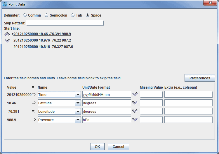
Delimiter
This field specifies how the different data values are separated within the text file. The options are Comma, Semicolon, Tab, and Space. Selecting this option allows McIDAS-V to separate out different text fields to allow for defining them at the bottom of this Point Data window.
Skipping lines
At the top, a number of the initial lines from the text data are shown. The arrow keys allow for specifying the start line. For example, if there were header lines in the file, these lines can be skipped over.
Specifying metadata
For each column of text data there is a row shown in the bottom of the dialog. This shows the sampled value and allows for entering a name, unit, date format, missing value and extra information. There are some names that McIDAS-V treats special: "Latitude", "Longitude", "Altitude", and "Time". At least Latitude, Longitude and Time must be specified in the file.
The Unit/Date Format field allows for specifying the Unit for data fields and the date format. For text fields choose Misc->Text as the unit.
The Extra fields must be of the form:
name="value"Don't forget the quotes!
Skipping columns
Certain columns can be skipped by entering the Name: "skip"
Saving this as a preference
To keep from having to enter in this data again the next time a new text point data of the same form is loaded, simply press the "Preferences" button and select Save
Current. This allows for saving these metadata settings and reapply them later
using the "Preferences" button.
Saving this as a data type through a plugin
To save the values in this Point Data window to a new data source so the Point Data window will no longer be needed, press the "Preferences" button and select Write Data Source Plugin
. This brings up a Data Source Type Plugin window where the user defines "Type" (not seen by the user) as well as "Label", which is how the data type will appear in the Data Type dropdown in the General->Files/Directories chooser. Clicking OK in this window brings up the Plugin Manager where a plugin can be written and installed using the new data type. The next time McIDAS-V is started, through the General>Files/Directories choose the new data type named in the Data Source Type Plugin, select the data file, and click Add Source. At this point, the data source will be added to the Field Selector without needing to define the columns in the Point Data window.