SSEC 2000 Highlights
by Terri Gregory and many others
Acronyms are listed at the end.
Momentous Occasions
(R.Kohrs)
Dawn of the Millennium image for January 1 combines GOES-East and West images to celebrate the new year over North and South America, is made available on the Web.
SSEC celebrates as MODIS’ earth view door opens February 24, and images are viewed in McIDAS within 24 hours via NASA/GSFC’s ADDE server.
Campus Open House brings about 300 people to our building in August, involving all building organizations.
Interim Director Hank Revercomb gives second annual State of SSEC speech; Dean Hinshaw presides.
We celebrate CIMSS’ 20th anniversary and our new MODIS antenna—talks and presentations, Governor’s proclamation, plaque, reception. Bill Smith, Paul Menzel, Dean Hinshaw all stress worldwide impact.
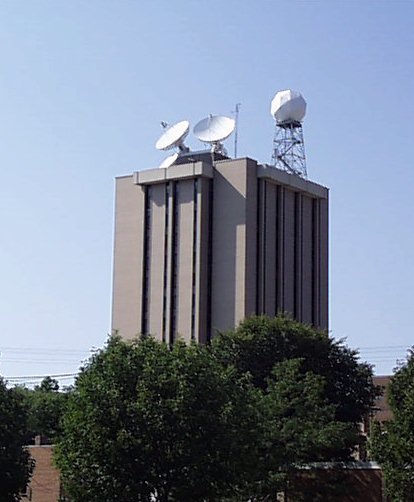
On August 5, SSEC’s building gained a new dome-covered antenna and a new data type—MODIS.
The SSEC X-band direct broadcast antenna completes a successful 30-day acceptance test in December through teamwork between SSEC and SeaSpace Corp., capturing over 100 MODIS passes automatically.
Research and Technology Advances
GIFTS, NASA New Millennium Program, gets underway as major new advance in geostationary observing.
Data Center supports reception of MODIS data through SSEC’s new X-band Direct Downlink Antenna.
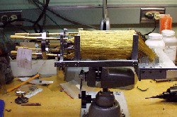
The Adiabatic Demagnetization
Refrigerator is shown with its hundreds of gold wires.
Adiabatic Demagnetization Refrigerator is selected for University of Chicago’s camera, HAWC, and is invited to be part of Joule, proposed replacement for the lost XRS, to cool detectors to almost absolute zero.
The Cloud InfraRed Radiometer for UnESS is one of four innovative concept studies funded in NASA’s University Earth System Science Project.
Oklahoma City tornado studies demonstrate the power of AERI-plus-GOES soundings for severe storm Nowcasting applications. (Wayne Feltz and Ralph Peterson)
Neptune dark spot study is one of 212 accepted for 9th Hubble Space Telescope observing cycle.
CIMSS’ Tropical Cyclones group’s satellite data analyses improve “initial position” errors in numerical models, leading to “a steady decrease in track forecast errors for Atlantic tropical storms and hurricanes.”
Lidar group receives support from DOD’s University Research Instrumentation Program that funds state-of-the-art equipment to enable faster scans with the Volume Imaging Lidar.
Infrastructure
Executive director Bob Fox retires and three execs replace him—John Roberts, Executive Director for Administration; Tom Achtor for Science; Fred Best for Technology.
Technical Computing and Data Center organize to effectively meet and survive the Y2K transition.
Schwerdtfeger Library wins funds for preservation of and access to substantial collection of Wilson Bentley’s photomicrographs of ice crystals taken by.
Email accounting notification modified to hold reports till a user requests them.
Technical Computing put extra Web serving capacity online to support hurricane season.
Phone and project lists are made available to Palm Pilot users.
The SSEC color poster printer works overtime to print jumbo-sized MODIS images in the first few weeks of MODIS operations. One or two non-MODIS researchers also print posters during the year…
The Knights of Technical Computing vanquish by the numbers:
- Resolve 1,973 formal requests
- Solve about 2000 informally reported problems (walk-ins, phone calls)
- Purchase, set up, deliver 30 PCs, more than a dozen laptops, and about 20 Unix machines.
- Retire more than 150 pieces of old equipment.
- Back up approximately 41 terabytes of data and perform 95 recoveries.
- Respond successfully to two dozen security incidents—SPAM relaying, anonymous FTP site abuse, system compromises.
- Store online more than 6 terabytes of information.
Innovative Collaborations
SSEC brings third major winter cloud experiment to Madison’s Truax Field—the Wisconsin Snow and Cloud–Terra 2000 experiment uses NASA’s ER-2 instrument measurements to validate NASA’s new satellite science products.
SSEC’s new Ice Coring and Drilling Service serves all National Science Foundation projects at high latitudes and high altitudes, from Greenland to Antarctica.
The biomass burning group continues to make data and expertise available to scientists in Canada and South America as well as in the U.S. during a year of serious wild fires.
Researchers SAFARI in southern Africa to validate Terra measurements with Scanning-HIS, to help solve continental climate puzzle.
The science of water vapor measurement is advanced by a 2-phased field program, led by SSEC personnel working with DOE ARM.
The International MODIS/AIRS Processing package is distributed by SSEC to process MODIS direct broadcast data in the USA, UK, Norway, Japan, Russia, Australia, China.
CIMSS scientists are a major force in GOES-11 science test.
SSEC scientists are noted users of Internet2 which provides high-speed access for collaborative research and interactive training and teaching.
More than half the images on NESDIS’ GOES derived-products poster are provided by CIMSS scientists.
Scott Lindstrom works with John Young (AOS) to record rain all during Dane County’s soggiest, rainiest, record-breaking summer.
Sun’s Java Web site features VisAD in its lead story for February 10, with Unidata and the National Center for Supercomputing Applications.
CIMSS scientists make GOES-derived products available to the Unidata community for feedback on their utility from a wider segment of the weather science community.
Rose Pertzborn chosen to exchange outreach expertise with NASA Headquarters.
SSEC collaborates with Raytheon, Goddard Space Flight Center, Swales Aerospace, Los Alamos and other esteemed organizations in the proposed Observing Platform for Ultraviolet Solar System Science, with an excellent chance of future funding.
Data and Information
First GOES-11 image, 11 May 2000.
First official GOES-11 image is posted on SSEC’s home page May 11, one week after launch, as the Data Center continues to handle GOES imagery best.
Thanks to close cooperation between CIMSS and the Data Center, CIMSS researchers use McIDAS daily to investigate radiometric performance and accuracy of MODIS products.
Automatic Weather Stations make possible “weather observations … across the 850 miles between McMurdo and the South Pole, … the continent’s busiest air route.” (Jack Williams, USA Today)
The Data Center receives and archives all Level-0 (unprocessed) MODIS data for scientists.
McIDAS version 7.7 is released.
CIMSS researchers process global MODIS datasets in-house on a 16-CPU SGI Origin2000 with 1 Terabyte of disk space, allowing rapid debugging and improvement of operational algorithms which are then delivered to NASA GSFC.
Data Center begins providing NOAA-16 data to McIDAS users.
Within hours of MODIS “first light,” images are prepared at CIMSS using custom IDL software which demonstrates that all spectral bands are alive.
Beautifully enhanced movie loops—hundreds of images—of hurricanes Georges and Bertha are provided to the Discovery Channel for a program on storms.
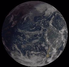
GMS image, artistically color-enhanced, shows dawn breaking over New Zealand on January 1, 2000.
We provide near real-time enhanced GOES imagery to the Grand Canyon Parks Service to aid them in their fight against forest fires.
Data Center provides GSAS archive data to universities free of charge via online ordering.
McIDAS adds Linux to its list of supported platforms.
SSEC makes good on a promise to routinely process MODIS direct broadcast data to Level-1B by the end of 2000.
IMAPP software for UNIX platforms distributed by SSEC under the GNU General Public License (GPL) is ported to Windows NT by ScanEx in Moscow, Russia.
Sky Aces, a local hot air balloon company, uses McIDAS data for flight and course decisions.
McIDAS Vsn. 7.7 is revised to handle MODIS data.
New MUG sites in 2000
- Meteorological Office of the United Kingdom
- NWS Honolulu, HI
- The Information & Computer Center – Mongolia
- Digital Cyclone, Inc.
- Meteorological Satellite Center – Japan
- Weathernews, Inc.
Service/Education
Wilt Sanders is new chair of the Academic Staff Executive Committee of the Academic Staff Assembly.
Jean Phillips is elected to a three-year term on the university’s Professional Development and Recognition Committee to help recognize academic staff.
UW—Madison’s summer Pre-college Enrichment Opportunity Program for Learning Excellence offers Space Exploration as a 3-week workshop for preteens.
The Schwerdtfeger Library, with other campus libraries, hosts exhibits on “Snowflake” Bentley.
Earth Science Component for Academic Professional Enhancement is one of 26 proposals funded out of 163 received by NASA’s Earth Science Enterprise Education Program.
SSEC’s Office of Space Science Education supports local middle schools in winter EarthKAM mission. The program and Web site hosting student pictures taken from the Space Shuttle are lauded.
Research
AMRC monitors largest proven iceberg ever, the Ross Ice Shelf’s B-15. B-17 and other bergs follow, some discovered by AMRC, bringing more public attention than any single weather event to SSEC and University Communications.
Completely redesigned CIMSS Web site sports search engine and links to most-sought pages.
Bill Hibbard guest edits February issue of Computer Graphics, a SIGGRAPH publication, focusing on new visualization techniques.
Weather research gets its own university promo—soggy pair of rubber boots catches eyes of regional-magazine readers.
UW—Madison’s physics department includes SSEC in new graduate brochure because “SSEC is an important attraction for potential physics graduate students.”
Dayne-o-Meter brings SSEC’s building national television exposure, delights Dean and Director.
Many SSEC and NOAA CIMSS people appear on radio and TV and in print and speak before audiences of all sizes and education levels—explain our work, provide expertise, challenge assumptions, broaden horizons.
Honors
Professor Emeritus Donald R. Johnson and Professor Francis Bretherton are named Fellows of the American Association for the Advancement of Science for their teaching, research and service.
Tim Schmit receives Department of Commerce Silver Medal for developing products with data from the latest generation of geostationary satellites.
Prestigious AMS Banner Miller Award for two significant papers on hurricane forecasting techniques. (Christopher Velden, Timothy Olander, and Steven Wanzong and CIRA colleague Raymond Zehr; published in Monthly Weather Review and Weather and Forecasting)
NOAA employees in SSEC’s Cooperative Institute for Meteorological Satellite Studies receive Bronze Medals for work on COMET and VISIT programs and Brazilian fire-monitoring activities.
SSEC’s EarthKAM program is one of thirteen university outreach programs honored by UW—Madison Chancellor David Ward in the fourth annual University & Community Partnerships event.
UW—Madison lidar research poster is best student poster out of 40 at the 14th Symposium on Boundary Layers and Turbulence. (Shane Mayor, Greg Tripoli, Ed Eloranta)
“Further Development of the International ATOVS Processing Package (IAPP)” receives first prize in the International ATOVS Study Conference-XI’s poster session. (Jun Li, Hal Woolf, Hong Zhang and Thomas Achtor)
Acronyms List
A3RI—Antarctic Astronomy and Astrophysics Research Institute
ABBA—Automated Biomass Burning Algorithm
ADDE—Abstract Data Distribution Environment
AERI—Atmospheric Emitted Radiance Interferometer
AIRS—Atmospheric InfraRed Sounder
AMRC—Antarctic Meteorological Research Center
AMS—American Meteorological Society
AOS—(Department of Atmospheric and Oceanic Sciences
ATOVS—Advanced TIROS-N Operational Vertical Sounder
CIMSS—Cooperative Institute for Meteorological Satellite Studies
DOD—Department Of Defense
EarthKAM—Earth Knowledge Acquired by Middle-schoolers
GIFTS—Geostationary Imaging Fourier Transform Spectrometer
GMS—Geostationary Meteorological Satellite
GOES—Geostationary Operational Environmental Satellite
GSAS—Geostationary Satellite Archive System
GSFC—Goddard Space Flight Center
HAWC—High-resolution Airborne Wide-band Camera
IDL—Interactive Data Language
IMAPP—International MODIS/AIRS Processing Package
Lidar—LIght Detection And Ranging
McIDAS—Man computer Interactive Data Access System
MODIS—MODerate-resolution Imaging Spectroradiometer
MUG—McIDAS Users’ Group
NASA—National Aeronautics and Space Administration
NESDIS—National Environmental Satellite Data and Information Service
NOAA—National Oceanic and Atmospheric Administration
NWS—National Weather Service
OSSE—Office of Space Science Education
SAFARI—Southern African Regional Science Initiative
SGI—Silicon Graphics Incorporated
SIGGRAPH—Special Interest Group on computer GRAPHics
SSEC—Space Science and Engineering Center
UnESS—University class Earth System Science
VIL—Volume Imaging Lidar
Vis5D—VISualization of Five-Dimensional data
VisAD—VISualization-Algorithm Development
VISIT—Virtual Institute for Satellite Integration and Training
WV IOP—Water Vapor Intensive Observing Period
XRS—X-Ray Spectrometer
Y2K—Year 2000