ATS-I Anniversary: SSEC Continues to Advance Technology
December 6, 19661 marks the launch anniversary of NASA’s Applications Technology Satellite-I (ATS-I). On board was the ground-breaking Spin-Scan Cloud Camera (SSCC) invented by Professors Robert Parent and Verner Suomi, founders of the Space Science and Engineering Center (SSEC) at the University of Wisconsin-Madison. With the camera, Suomi demonstrated the value to weather forecasting of utilizing geostationary orbit (22,000 miles above the equator) for monitoring cloud motion from a satellite platform. The camera provided full disk visible images of the Earth and its cloud cover every twenty minutes.
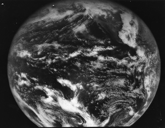
ATS-I image from December 11, 1966. Credit: NASA.
For the first time, scientists could observe weather systems as they developed. Satellite remote sensing technology was suddenly transformed from producing interesting snapshots into gathering of meaningful, quantitative data that could be used to improve weather forecasts. The sequential pictures of cloud movements provided a breakthrough in visualizing and comprehending atmospheric circulation. According to the late Suomi, “the clouds move; not the satellite.” This concept revolutionized satellite meteorology. The weather satellite images and “movies” of weather in motion seen on the evening news and on many web sites are a direct result of Suomi’s invention.
height=”424″ Weather in motion from the ATS-I synchronous satellite, by V.E. Suomi, A.F. Hasler, and J. Kornfield, University of Wisconsin-Madison, Department of Meteorology. Produced by Jack Lund, University of Wisconsin-Extension, Department of Photography, n.d. 9 minutes, silent, black and white.Since the 1960s, the advances in weather forecasting have been extraordinary – today the Geostationary Operational Environmental Satellites (GOES) operated by the National Oceanic and Atmospheric Administration (NOAA) can transmit nearly continuous imagery and data, making it possible to issue earlier and more detailed warnings when severe weather develops.
SSEC scientists along with partners at the Cooperative Institute for Meteorological Satellite Studies (CIMSS) and NOAA’s Advanced Satellite Products Branch (ASPB) continue to advance and improve the U.S. geostationary satellite program. They are making vital contributions to GOES-R, the next generation geostationary satellite, through instrument trade studies, algorithm development, risk reduction, and proving ground preparations for operations.
GOES-R, scheduled to launch early in 2016, will be comprised of improved spacecraft and instrument technologies, which will result in more timely and accurate weather forecasts, and improved support for detecting severe weather events that affect public safety.
By Jean Phillips
1 NASA’s official launch date is December 7, 1966 (UTC), which is December 6, 1966 (local Madison time).
Featured image caption: Robert Parent (left), V.E. Suomi (second from left), and colleagues view ATS photos made possible by the Spin-Scan Cloud Camera. Photo credit: UW Communications.