Calculating instability: Combining surface- and space-based measurements for improved forecasts
Weather forecasters have long known that areas of instability in the atmosphere, where different air masses clash and mix, are more likely to produce severe storms. They also know that one of the keys to severe weather prediction is an accurate and reliable measure of that atmospheric instability.
Convective Available Potential Energy, or CAPE, is a value that meteorologists use to estimate the relative instability of a region. Each day CAPE calculations are derived from a series of measurements captured through weather balloon radiosondes and data from weather satellites like NOAA’s Suomi NPP and NOAA-20. But due to gaps in data coverage and some physical limitations of satellites, CAPE values are sometimes underestimated, leaving places like cities potentially at risk of reduced warning for severe weather.

UW-Madison CIMSS research intern Callyn Bloch. Credit: Callyn Bloch
Callyn Bloch, a research intern at the University of Wisconsin–Madison Cooperative Institute for Meteorological Satellite Studies (CIMSS), has been studying the problem of underestimated surface-based CAPE values from satellites. Her research has led to a method for improving CAPE accuracy that relies on a combination of ground-based and satellite derived datasets. Bloch’s research results were published in the Journal of Applied Meteorology and Climatology in August.
“Severe weather can happen during daytime heating, and we don’t always get those observations between weather balloon launches that occur only once in the morning and once in the evening in the US,” says Bloch. “That’s the benefit of the satellite profiles, which can capture that missing information.”
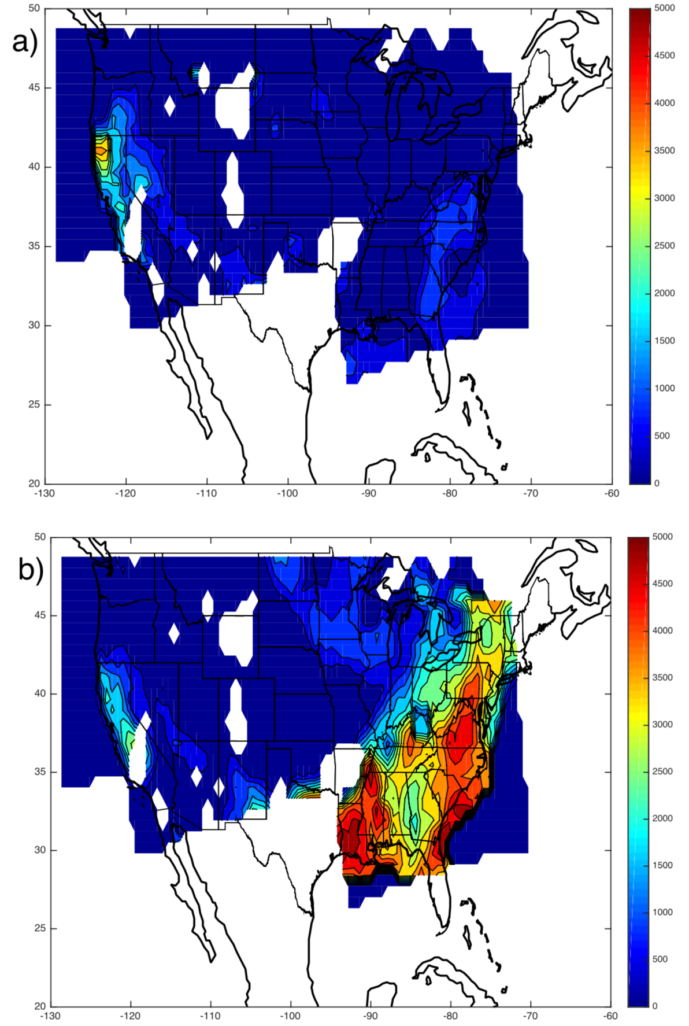
A comparison of Convective Available Potential Energy (CAPE) calculations for June 18, 2017, figure a shows CAPE values from the Suomi NPP hyperspectral infrared sounder without the use of ground-based MADIS data. Figure b shows the same date and time but with satellite and ground-based data integrated, resulting in a more accurate CAPE calculation. CAPE values less than 1000 (J/kg) are considered weak instability, values greater than 4000 (J/kg) are considered to be extremely unstable. Credit: Callyn Bloch
A combination approach is used by meteorologists to get a complete picture about the state of the atmosphere at a given time. Weather balloon radiosondes provide crucial data about the Earth’s boundary layer, but satellites struggle to accurately detect changes close to the Earth’s surface. Bloch argues that using satellite data alone (in the absence of boundary layer information) can lead to underestimated CAPE values in cases when the atmosphere is highly unstable.
Bloch cites two instances from June 18, 2017 over the Eastern US and July 3, 2017 over Oklahoma and Texas where strong CAPE values were present and severe weather formed but satellites failed to detect any risk.
To address this problem, Bloch developed a near real-time visualization product that takes advantage of ground-based measurements that are aggregated in NOAA’s Meteorological Assimilation Data Ingest System (MADIS). MADIS archives these daily data collected from airports, lake buoys and roadside weather stations. Bloch’s product can then be launched in RealEarth, a visualization program developed at the Space Science and Engineering Center.
“CAPE estimations can be sensitive, so if a satellite’s measurements are off by one or two degrees Celsius, it can greatly affect its value,” says Bloch. “When we combined the MADIS data with the satellite observations the results were close to those actually observed, nearly identical with the same CAPE boundaries and values.”
Looking ahead, Bloch says she would like to investigate ways to improve the resolution of the near real-time data and also integrate data from EUMETSAT’s MetOp satellite, which would provide greater coverage of the US during the morning hours.
This work was supported by the NOAA JPSS Cal/Val program.