Tracking winds: Study compares atmospheric wind calculations from six agencies
Wind speeds, their direction and height, are important measurements in the global observing system and weather forecasting.
The process for deriving them, starts with tracking clouds and water vapor signals in satellite images at regular intervals to obtain Atmospheric Motion Vectors (AMVs). These derived AMVs are then incorporated into numerical weather prediction models. One challenge however, facing the meteorological community is that different agencies use slightly different methods for processing these data, resulting in discrepancies.
To improve our understanding of the similarities and differences of calculated AMVs, several institutes from around the world participated in an atmospheric motion vector intercomparison study to test their methods and strategies in a series of standardized experiments. Scientists at the University of Wisconsin–Madison Space Science and Engineering Center, in partnership with other American, European, Korean, Japanese and Brazilian collaborators, conducted the fourth intercomparison study since 2008. The results of the study appear in the November 2019 Satellite-Derived Wind Observations special issue of Remote Sensing.
“These tests help AMV producers in terms of identifying errors in their algorithms so they can make improvements,” says David Santek, SSEC scientist and co-author. “In addition, the numerical weather prediction centers, which are the primary users of the data, can see how well the different centers derive their AMVs and give them an idea how they can quality control them with consistent results.”
All of the groups showed improvements since the last study was conducted in 2014. The current study aimed to understand how the next generation of geostationary satellites – like Japan’s Himawari-8 and the US GOES-16 – can improve AMV calculations because imagery from the two satellites have greater spatial and temporal resolutions.
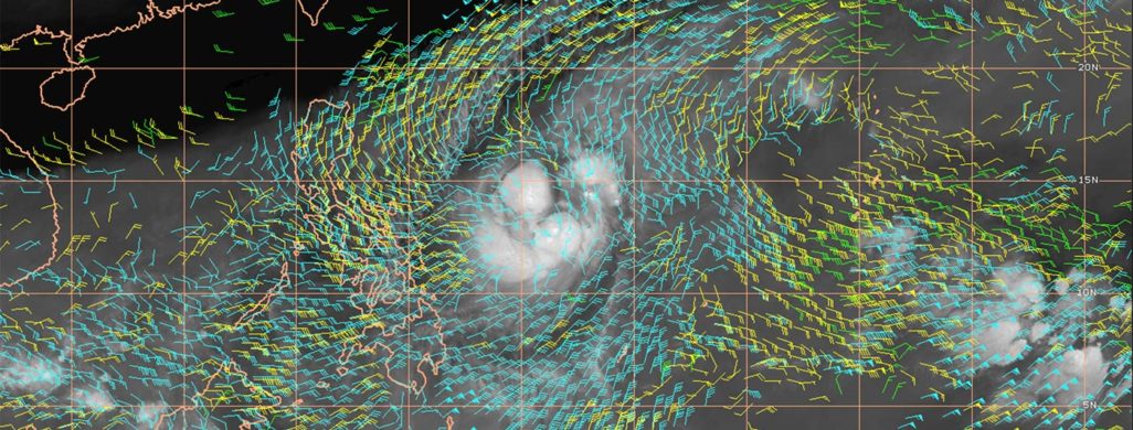
AMVs are calculated by analyzing a series of consecutive satellite images. The process involves selecting a “tracer,” a recognizable feature like a cloud and tracking it over time. A key result from the study showed that accurate cloud-top estimations were an important indicator for AMV calculations. Wind speed and direction can change drastically depending on the conditions that day and height, making the process of determining a cloud’s top less than straightforward.
The study ran a series of three experiments with each of the participating agencies using satellite imagery from the geostationary satellite Himawari-8 and various channels from its Advanced Himawari Imager. In the first two, specific parameters were put in place to determine how well each of the algorithms performed a specific task. The third experiment was less controlled, allowing for the use of best options to assess AMVs.
Since the 1970s, satellite data have been used to improve weather forecasts, at first by hand, and later automated in the 1990s. Santek says these calculations are especially useful for remote areas around the world, where ground-based and radiosonde data are sparse.
The results of this study will be discussed at the next International Winds Working Group meeting in April 2020, hosted in Utrecht, Netherlands.
This work was supported by the EUMETSAT Satellite Application Facility on Nowcasting and Very Short Range Forecasting.