Coldest cloud temps recorded by weather satellite
Cloud temperatures can mean severe weather is on its way. The colder the cloud top, the greater its potential to trigger high winds, heavy rain, hail, lightning and tornadoes.
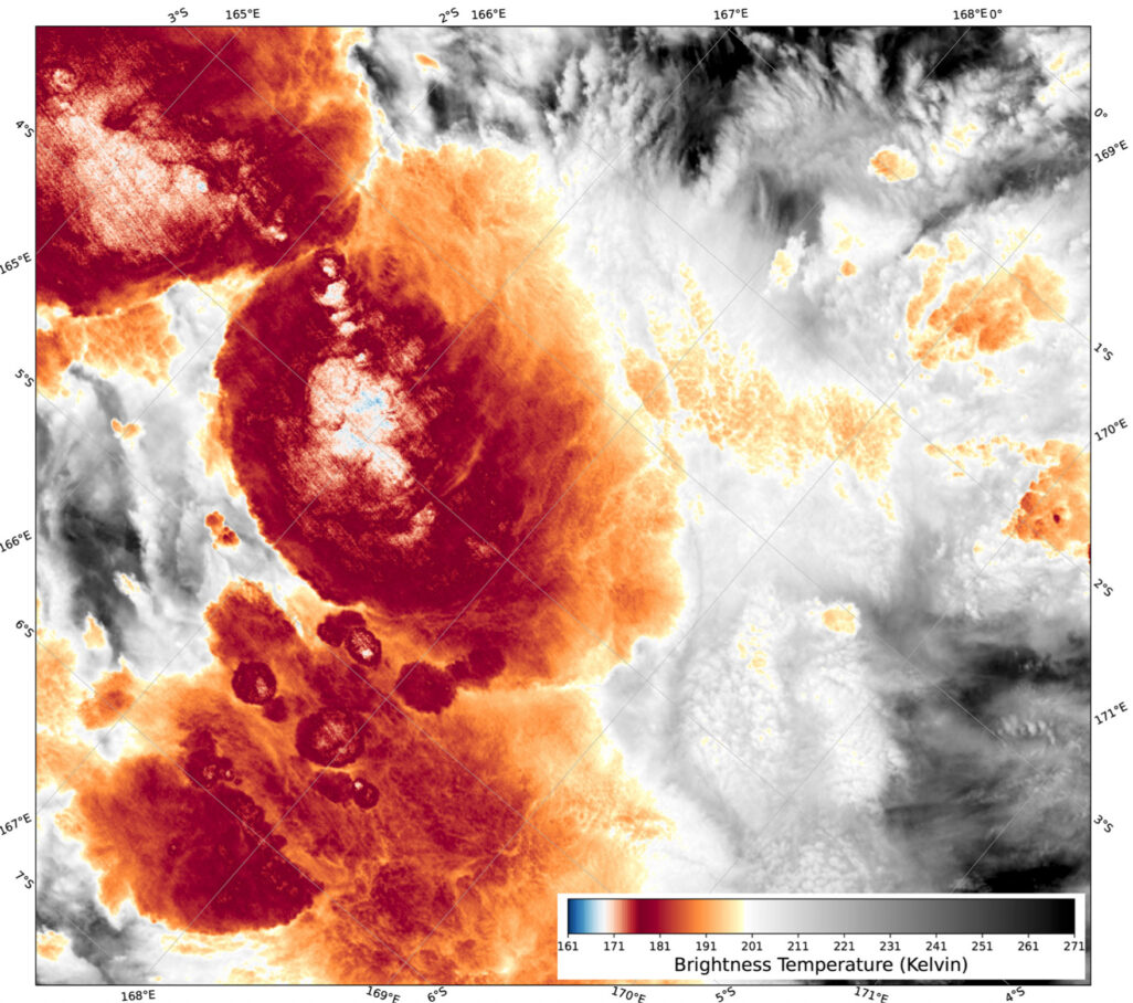
Scott Bachmeier, a researcher at the UW-Madison Cooperative Institute for Meteorological Satellite Studies, is co-author on a study that identified the coldest cloud top temperature on record during the satellite era, -111 degrees Celsius (-168 degrees Fahrenheit), as recorded by the NOAA-20 weather satellite. The analysis was published in Geophysical Research Letters in Spring 2021.
A comparative analysis of cloud top temperature data over time provides atmospheric scientists with more information that can be used to better predict the potential for severe weather. The data may also be important as scientists monitor and learn how storm systems may become stronger as the result of climate change.
“Measuring a cloud’s coldest temperature is a good way to gauge the height of cloud tops, which helps to estimate the stage of storm development or its potential to produce severe weather,” says Bachmeier.
The record cold temperature was measured with the Visible Infrared Imaging Radiometer Suite (VIIRS) aboard the NOAA-20 weather satellite. Bachmeier says VIIRS is capable of measuring temperatures as low as -173 Celsius (-279 Fahrenheit).
Cold temperatures like those recorded by NOAA-20 over the Southwest Pacific Ocean in December 2018 occur in what are called overshooting tops – an area of intense convection that breaks through the upper ceiling of an anvil-cloud. Anvil-clouds (or cumulonimbus) extend high into the Earth’s atmosphere where temperatures are much colder than on the surface. When an overshooting top punches through the tropopause, strong convective forces can become the fuel for intense weather.
“Severe thunderstorms create an environment that supports the development and maintenance of vigorous tropopause-penetrating updrafts and can create a convective storm that is more likely to produce damaging winds, large hail or tornadoes,” says Bachmeier.
Additionally, the study analyzed cloud temperature data from 2004-2020 that show an increase in the number of instances where cloud tops reach very cold temperatures (below -105 degrees Celsius/-157 Fahrenheit). A rising trend of cold tropopause temperatures could contribute to the development of more frequent severe weather that results in extreme events like flooding.
It is possible that colder cloud-top temperatures may have occurred in the past, but until the 1970s higher-resolution satellite instruments were unavailable to measure them.
This work is supported by the UK Natural Environment Research Council and NOAA.