Collaborating on the first hyperspectral infrared sounder in geo orbit
Accurate measures of temperature and moisture profiles are important for tracking high-impact weather, such as supercells or tropical cyclones. Until now, weather forecasters had to rely on dropsondes, devices dropped from aircraft above the storm to measure these atmospheric parameters as they fall. Their usefulness is limited by their coverage.
However, hyperspectral infrared sounders designed to be carried on weather satellites can detect outgoing longwave radiation, delivering precise, vertical profiles of temperature and moisture that are crucial for forecasting as well as data assimilation into weather models.
Currently, the United States does not have such an instrument on its geostationary satellites but a HIS instrument was included on two Chinese geostationary satellites: FenYun-4A launched in 2016 and FenYun-4B launched in 2021. Both are part of the FY-4 series that will include seven geostationary meteorological satellites located over China.
Now, a collaboration between the University of Wisconsin–Madison Space Science and Engineering Center and a US interagency partnership, the Joint Center for Satellite Data Assimilation is aimed at inclusion of a geostationary HIS, or GeoHIS, on US satellites in the future in order to better predict and track high-impact weather. The HIS concept has been under development at SSEC since 1979 with support from the National Oceanic and Atmospheric Administration and NASA.
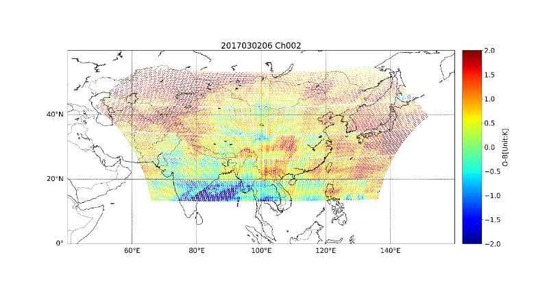
Wei Han, a recent visiting scientist at SSEC from the JCSDA, along with SSEC Senior Scientists Robert Knuteson and Jun Li have been evaluating data from the Geostationary Interferometric InfraRed Sounder, a HIS instrument on the Chinese FY-4 series satellites. Their analysis and observations about the advantages of the GeoHIS were published in the JCSDA Quarterly Newsletter in Summer 2021.
While the US lacks a GeoHIS, similar operational sensors onboard polar orbiting satellites, particularly the Cross-track Infrared Sounder on the Joint Polar Satellite System series, are demonstrating their value. Polar orbiting satellites provide global coverage, but only scan the same location twice a day, whereas the GeoHIS, if widely adopted for use on geostationary satellites, would provide continuous coverage between the polar orbit readings for a more complete picture.
“One of the major benefits from having a GeoHIS is the detection of severe weather events like tropical storms and supercells,” says Han. This is due to the high temporal resolution monitoring of the same location that geostationary satellites provide.
The FY-4A GIIRS has shown immediate benefits for nowcasting that forecasts the weather over the next few hours based on current conditions.
“Most severe weather indices use temperature and dewpoint profiles,” explains Knuteson, “and so you’d like to monitor the changes in these profiles throughout the diurnal cycle because of daytime heating over land in the pre-convective environment.”
Numerical Weather Prediction will benefit from the assimilation of GeoHIS data, and has already seen improvements to typhoon forecasts using the FY-4A GIIRS. By monitoring winds through frequent measurements, forecasters can better predict typhoon intensity and track.
Knuteson and Han have developed methods to quality control GIIRS data that include comparing these data to polar orbiting HIS data to check the accuracy. This is an important step, because in order to assimilate the data into the NWP model, the data must be consistent and accurate.
SSEC scientists have collaborated with NWP scientists for GIIRS data assimilation, and have found their collaboration to be fruitful. “I want to emphasize the collaboration between the calibration team at SSEC and the NWP data assimilation team,” says Han. “We needed to work together to achieve the results we have now. Hopefully we will have more of these interactions and collaborations going forward in other projects.”
The FengYun-4 geostationary satellites may be the first geostationary satellites to include a hyperspectral infrared sounder, but there are more under development. The European Organization for the Exploration of Meteorological Satellites is planning to launch its own geostationary satellite with hyperspectral IR sounders sometime in 2024. One of the goals of the SSEC project is to help develop a similar GeoHIS for a new series of geostationary satellites for the US called Geostationary Extended Orbit, or GeoXO. This NOAA program will be an addition to, and replacement for, the GOES-R series, which do not have a HIS onboard.
Read more about GeoHIS in the JCSDA Quarterly article.
This work is funded by NOAA.