Monthly News Summary – January 2010
- Successful GOES-14 Post-launch Check-out
- Matthew Lazzara Blogs from Antarctica
- Steve Ackerman Presents at K-12 Presidential Awards Program
- Projects and Publications
Successful GOES-14 Post-launch Check-out
The Cooperative Iinstitute for Meteorological Satellite Studies (CIMSS) and the local NOAA/NESDIS group participated in the recent post-launch check-out Science Test of the latest in the NOAA Geostationary Operational Environmental Satellite (GOES) series. This satellite is denoted as GOES-14 and was launched on 27 June 2009.
Satellite products were generated throughout the Science Test period, which basically covered a bit more than the month of December 2009. These included temperature and moisture profiles, cloud-top information, and atmospheric motion vector winds. In addition, many interesting, and timely, blog entries were generated, on topics including: the improved navigation and registration of GOES-14, ‘vog’ (volcanic smog), ice motion, snow, stratospheric intrusion vortices, blowing dust, rapid scan imagery (e.g., of a major East Coast winter storm), lake effect snow, fires, standing waves, special full disk Earth images, and volcanoes.
The quick posting of displays and accompanying discussion, on such “news items” as the East Coast winter storm of 18-19 December 2009, the Midwest blizzard of 08-09 December 2009, and the volcanic eruption in Colombia on 03 January 2010, was sought to capitalize on the current popular interest in these weather and geophysical events, to show the relevance of improving the NOAA geostationary satellite capabilities.
These examples can be found at:
http://cimss.ssec.wisc.edu/goes/blog/archives/category/goes-14.
With conclusion of this intensive data collection phase, the next step is further analysis of the instrument and product performance. This is a critical step for the instrument to be later used operationally.
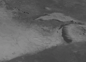
GOES-14 visible image at 1900 UTC on 11 December 2009, showing both lake effect snow across the Great Lakes, as well as the snow cover swath on the ground from the early December storm across the northern US Plains to southern Wisconsin and northern Illinois.
submitted by Tim Schmit
Matthew Lazzara Blogs from Antarctica
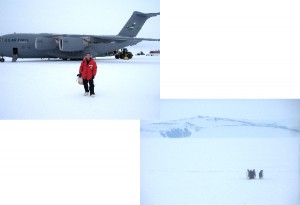
01/10/10 Post: On the ride from Pegasus to McMurdo, we got to see a rare site for me – Penguins! Four emperor penguins have been hanging around the area – and are presently camped along the road to the airfield! Word has it more Adelie penguins are close to the station as well – I’ll have to see if I can catch them visiting us sometime.
Keep up with the current adventures of the Antarctic Meteorological Research Center team via Matthew Lazzara’s blog at: http://amrc.ssec.wisc.edu/blog
Steve Ackerman Presents at K-12 Presidential Awards Program
Steve Ackerman gave an invited presentation at the Presidential Awards for Excellence in Mathematics and Science Teaching (PAEMST) program in Washington, D.C. on Tuesday, 05 January 2010 (http://recognition.paemst.org). Through Dr. Ackerman’s presentation, the awardees learned about water cycle connections to climate change via tools and activities developed at the Cooperative Institute for Meteorological Satellite Studies (CIMSS).
Margaret Mooney Re-Elected Chair of ESIP Education Committee
Ackerman was assisted by Margaret Mooney who was in DC for the Federation of Earth Science Information Partners (ESIP) conference where she was re-elected Chair of the ESIP Education committee for 2010.
TEXAQS II Air Quality Manuscript Published: A manuscript entitled “An observational and modeling strategy to investigate the impact of remote sources on local air quality: A Houston, Texas, case study from the Second Texas Air Quality Study (TexAQS II)” by W. W. McMillan, R. B. Pierce, L. C. Sparling, G. Osterman, K. McCann, M. L. Fischer, B. Rappengluck, R. Newsom, D. Turner, C. Kittaka, K. Evans, S. Biraud, B. Lefer, A. Andrews, and S. Oltmans was published in the Journal of Geophysical Research. The manuscript addresses one of the key goals of the 2006 Texas Air Quality Study by documenting the contribution of distant pollution sources to poor air quality in the greater Houston region. The study illustrates how carbon monoxide (CO) retrievals from the Advanced InfraRed Sounder (AIRS) and aerosol optical depth (AOD) retrievals from the Moderate Resolution Imaging Spectroradiometer (MODIS) can be combined with chemical and aerosol analyses from the Real-time Air Quality Modeling System (RAQMS), wildfire trajectories, and surface measurements to understand the influence of long-range pollution transport on Houston air quality. The study shows that transport of polluted air from Pacific Northwest wildfires behind a cold front lead to increases in background CO observed at the Moody Tower in Houston, TX on 31 August 2006.
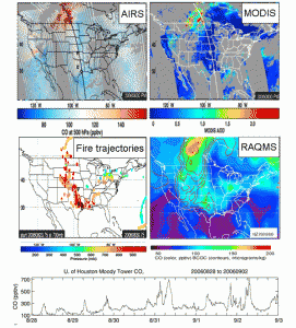
AIRS 500mb CO (upper left), MODIS AOD (upper right), Pacific Northwest wildfire trajectories (middle left), RAQMS 700mb CO and black and organic carbon (BCOC) aerosols (middle right) on 30 August 2006 along with a timeseries of surface CO from the University of Houston Moody Tower showing the impact of Pacific Northwest wildfires on background levels of CO in Houston, TX.