Monthly News Summary – May 2007
SSEC planetary scientist wins prestigious university award
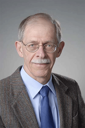
SSEC planetary scientist Dr. Lawrence Sromovsky won the 2007 Chancellor’s Award for Excellence in Research by an Independent Investigator.
Photo Credit: Aaron Mayes, University Communications
From designing an instrument to measure the atmosphere on Venus to observing the seasons on Neptune, SSEC planetary scientist Lawrence Sromovsky has made significant contributions to our understanding of our solar system. In a ceremony on May 15, UW-Madison honored Sromovsky and his dedicated pursuit of knowledge with theChancellor’s Award for Excellence in Research by an Independent Investigator.
“Larry’s remarkable achievements follow from his strong drive for truth and understanding and his strict objectivity,” said SSEC Director Hank Revercomb in his nomination letter. “He is versatile, combining unusual theoretical understanding, physical instincts, and experimental talents.” Revercomb has worked closely with Sromovsky throughout his career.
As a high school freshman in Michigan, Sromovsky founded a rocket club. Using plumbing materials from his grandfather, Sromovsky and his friends concocted a recipe for rocket fuel and devised vehicles to launch into the sky. “I had no idea at the time that I would some day be watching a rocket take off for Jupiter with my instrument on it,” Sromovsky says.
Read more about Dr. Sromovsky.
In the field: SSEC helps validate new satellite instrument
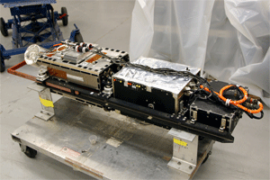
SSEC’s Scanning HIS was one of several instruments that contributed to this field experiment. The Scanning HIS provides high resolution measurements of radiation from the Earth’s atmosphere.
Based in Houston, Texas, the Joint Airborne IASI Validation Experiment(JAIVEx) yielded a wealth of extremely useful datasets that will contribute to validation of the Infrared Atmospheric Sounding Interferometer(IASI) and other instruments aboard the first satellite in Europe’s polar-orbiting meteorological satellite system. Collaborating with research teams from both sides of the Atlantic, numerous SSEC personnel participated in the field program by providing support for two aircraft-based instruments, Scanning-HIS and NAST-I.
Using two high-altitude aircraft, one from the UK Met Office and one from NASA, the teams in the field flew several instruments underneath the satellite as it passed over the Gulf of Mexico and over the U.S. Department of Energy’s Atmospheric Radiation Measurement – Cloud And Radiation Test-bed site (ARM-CART) in Oklahoma. Experiment participants at the ARM-CART site also coordinated and launched weather balloons, or radiosondes.
The JAIVEx field program has several objectives. The primary goal is to validate and characterize measurements from IASI. Data from this instrument will improve weather, climate, and air quality observation and forecasting. Another piece of the JAIVEx experiment is to validate the performance of different algorithms designed to retrieve temperature, humidity, ozone and carbon monoxide profiles from IASI data gathered over land and the ocean as well as under both cloudy and clear sky conditions. JAIVEx also produced a diverse set of observations from IASI with measurements made at the same time and place using airborne and in-situ observations. This information will further the development of innovative techniques to assimilate IASI data into numerical weather prediction models, utilizing as many channels as possible, over different surface types and under a variety of conditions.
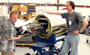
SSEC’s Denny Hackel and Nick Ciganovich integrate the Scanning HIS into a pod that attaches to NASA’s WB-57. Measurements from this instrument and NAST-I will help validate IASA measurements.
Participants from SSEC worked with two instruments aboard NASA’s WB-57, which flew in the stratosphere about 11 miles from the ground and above the area of the atmosphere where weather develops. The NPOESS Atmospheric Sounder Test-bed-Infrared (NAST-I) and Scanning High-resolution Interferometer Sounder (S-HIS) collected data that will provide insight into the accuracy and quality of IASI measurements.
The UK MetOffice’s aircraft flew in the troposphere, the first layer of atmosphere above the surface layer, using both in-situ measurements from aircraft probes and dropping radiosondes to directly measure the surface emission characteristics and the state of the atmosphere. Radiometric measurements with the Airborne Research Interferometer Evaluation System (ARIES) can be directly compared with IASI data.
SSEC’s support of JAIVEx extended back to Madison, WI. For example, an experimental numerical weather prediction model developed at CIMSScontributed to daily forecasts for the field experiment. The CIMSS Regional Assimilation System (CRAS) integrates satellite data into weather forecasts and provided field experiment participants with another tool to determine the best times to fly the aircraft. Now that the field portion of the project is complete, SSEC personnel will contribute to analyses of the data.
–Dave Tobin
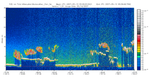
CIMSS researchers plan to use observations from a new environmental satellite to improve the quality of wind measurements derived from satellite data. Above is an example of a backscatter signal, which helps researchers determine where the edges of the clouds are. Click for a larger image.
Above the clouds with CALIPSO (by Iliana Genkova)— Using data from a new environmental satellite, a team of researchers led by CIMSS has started an effort to improve the quality of wind measurements derived from satellite observations. Initially the team plans to more accurately ascertain the altitudes of clouds tracked to deduce information about the wind.
A Cloud Motion Vector (CMV) indicates the direction and speed of a cloud’s movement. Assigning the correct height to a CMV is a key element to the successful assimilation of this information into numerical weather prediction models. To improve the quantity and quality of assimilated CMVs, it is necessary better understand errors that occur in height assignment.
Information obtained by Geostationary Operational Environmental Satellites (GOES) desginates the height of a CMV. Researchers typically estimate errors by comparing the CMV with observations from radiosondes launched aboard weather balloons during the same time frame and in the same area. A disadvantage of these traditional comparisons is that it is difficult to diagnose the components and causes of CMV errors. To better characterize these errors, CIMSS scientists plan to assess height assignments by comparing CMVs with observations from an instrument aboard a new environmental satellite called CALIPSO. Using data acquired from CALIPSO as it flies in the field of view of the GOES satellites will provide precise cloud height information that can be compared with and used to validate height assignments derived from GOES data.
Following this investigation, the CIMSS team plans to adjust for biases inherent to the current height assignment method, which will improve the CMV data record used in data assimilation. Comparisons of collocated CALIPSO cloud altitudes and operational GOES and MODIS CMV height assignments will reveal error characteristics. When accounted for, this information should increase the use of CMVs in forecast models.
Jim Kossin, a CIMSS tropical cyclones researcher, recently collaborated with the National Climatic Data Center to develop a dataset that will improve prediction of a hurricane’s damage potential.
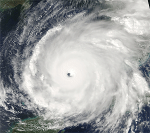
Hurricane winds—An improved record of information about winds associated with hurricanes has evolved through continued collaboration between CIMSS scientists and theNational Climatic Data Center (NCDC). Currently, details about storm structure and size are limited and expanding the available data is a high priority for theNational Hurricane Center forecast office.
In service of this goal, CIMSS’s Jim Kossin and scientists at NCDC explored the relationships between GOES infrared imagery, and the structure and size of low-level wind fields associated with hurricanes. Using this data, CIMSS and NCDC have significantly extended the record of critical wind radii in hurricanes. This new record is unique and will help us better understand the damage potential of hurricanes. For example, Hurricane Charley (2004) was stronger at landfall than Hurricane Katrina (2005), but Charley’s compact size constrained the associated damage and the size of the storm surge. These wind radii are now available for all storms during the period 1983–2005. The new data comprise a systematic compilation of GOES imagery during this period, and will be updated annually through the present period and into the future.
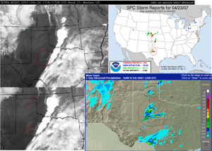
CIMSS has received positive feedback from NWS forecasters. A forecaster from the Milwaukee/Sullivan office specifically pointed out the distinct features of a storm cell in a MODIS image from April 23.
Supporting operational forecasts—A team of CIMSS researchers has continued to expand on the strong collaboration with operational forecasters at National Weather Service (NWS) offices in Wisconsin and around the U.S. Since the project began in summer 2006, CIMSS researchers have integrated several types of new satellite data into the Advanced Weather Interactive Processing System (AWIPS), which NWS uses to process and analyze weather data. In early May, CIMSS added a winds product derived from Geostationary Operation Environmental Satellite (GOES) data to the products available to the Milwaukee/Sullivan forecast office.
References to satellite data products from SSEC/CIMSS have appeared in many forecast discussions and forecasters have responded positively. Recently, Jeff Craven, a forecaster at the Milwaukee/Sullivan office, commented on the quality of SSEC’s products derived from the MODerate resolution Imaging Spectroradiometer (MODIS). SSEC’s MODIS products are particularly useful to forecasters because SSEC can receive data directly from the instrument through an special antenna on the roof of the center’s home on the UW-Madison campus. The direct broadcast capability means that SSEC products are available sooner than conventional sites and are therefore more useful to forecasters. Craven specifically pointed out the distinct features of a storm cell in a MODIS image from April 23. He also marveled at the appearance of increase moisture in the soil the day after the storm. “You can certainly take examples like these to the bank on how higher resolution can shows these soil moisture gradients that can potentially affect convective development for several days, especially as we go deeper into the warm season,” Craven says.
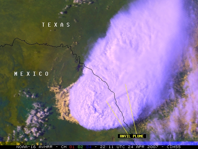
On April 24, a tornado tore through Eagle Pass, TX. The tops of the clouds in the area are visible in this satellite image.
Tornados in the blogsphere—Satellite images of the recent deadly tornados in Kansas and Texas appeared in the CIMSS Satellite Blog courtesy ofScott Bachmeier. On April 24, a storm began developing in Texas. One of the U.S. geostationary satellites was in rapid scan mode at that time, allowing researchers towatch the storm develop at five-minute intervals. The tornado that tore through Eagle Pass, TX was a part of the same storm that produced hail measuring almost 3 inches in diameter and winds reaching close to 80 mph.
On May 6, Bachmeier wrote about what he calls “the largest outbreak of severe weather so far this season.” Producing tornados from Texas to South Dakota, the storm system developed and moved across the central U.S. from May 4-6. The system pelted Nebraska with hail reaching 4.25 inches in diameter and swept through Kansas with winds up to 90 mph. The severe convection led to the formation of the tornado that devastated Greensburg, Kansas. According to Bachmeier, this tornado qualified as the first EF-5 tornado in the U.S. since May 1999.
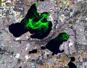
Jonathan Chipman with ERSC created this image using scenes from Landsat taken over several dates.
Seeing chlorophyll via satellite—An image of Madison’s Lakes Mendota and Monona showing green swirls of algae accompanied an article in the May 9 edition of Wisconsin Week, a campus newspaper. Jonathan Chipman with SSEC’sEnvironmental Remote Sensing Center (ERSC) created the image using scenes from Landsattaken over several dates. Chlorophyll has a distinct spectral signature that can be measured by satellites. The image illustrated an article about a water quality study.
Preparing to use the big drill—This fall, SSEC’s Ice Coring and Drilling Services (ICDS) group will pack up their new Deep Ice Sheet Coring(DISC) drill to go to Antarctica in support of a project to study the climate record preserved in the ice. The West Antarctic Ice Sheet (WAIS) Divide Ice Core Project recently appeared in The Economist and The Antarctic Sun.
Published on March 29, the article in The Economist highlights the importance of the WAIS project: “The WAIS Divide core should … provide the most accurate record to date of atmospheric carbon dioxide, a green house gas that lies at the heart of climate change.” The article also mentions the contributions of the DISC drill: “Over the next four years the project’s members will use a long, hollow drill to cut and retrieve a cylinder of ice roughly 3.5km long and 12cm across.”
This fall, SSEC’s Ice Coring and Drilling Services (ICDS) group will pack up their new Deep Ice Sheet Coring (DISC) drill to go to Antarctica in support of a project to study the climate record preserved in the ice. This picture is from the test run of the drill in Greenland.
The January 7 editionThe Antarctic Sunincluded an article titled “More stories about life and science at WAIS.” The article mentions some of the work that ICDS has already done at the project site. A sidebar details two drilling innovations that the ICDS crew has tested at the WAIS site.Jay Kyne, a field engineer with ICDS, devised the methods to put two ideas to improve core quality into practice: a change to the shape of the drill cutters to reduce nicks and cracks, and the addition of a metal ring that sits just inside the drill to break of the extra ice without causing the core to crack. “It’s easy to make a hole, but it’s hard to produce good core quality,” the article quotesBella Bergeron, an ICDS contract driller.
The ICDS crew began work at the WAIS Divide site last year, drilling several shallow holes to provide cores before construction activities disturbed the area. This year members of the ICDS team drilled the pilot hole for the deep core. Reporter Steven Profaizer included the process of creating the pilot hole in his article for the Sun. Images of ICDS contract drillers and equipment accompanied the article.
April snow showers—Snowstorms in southern Wisconsin on April 11 blanketed Madison and Milwaukee with record-breaking amounts of snow. SSEC’s Scott Lindstrom provided some facts about April snowfall in Madison to David Medaris of Isthmus, a local Madison newspaper. As reported by Lindstrom, Madison’s previous record for snow accumulation on April 11 was set in 1997. This year’s snow broke the previous record of 3.8” with an impressive 5.4”.
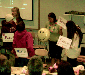
Dr. Cherilynn Morrow leads a group of students in a Kinesthetic Astronomy activity that demonstrates the changing seasons on Earth.
One Sky, Two Views conference—The first “One Sky, Two Views” Native American and Space Science Cultural Conference was conducted in cooperation with the Wisconsin Indian Education Association on April 13 at the Lac du Flambeau Reservation in Northern Wisconsin. Funded by the Baldwin Endowment, the project is a unique collaboration featuring contemporary earth and space science themes in the context of the traditional Native American views of the natural world. As a part of the program, earth and space scientists partnered with tribal elders to present “Two Views” on selected themes representing contemporary space science research as well as major cultural significance to tribal communities. Br. Guy Consolmagno from the Vatican Observatory and Leon Valliere of the Lac du Flambeau Ojibwe Nation discussed meteors and asteroids. Dr. Cherilynn Morrow of the SETI Institute and Dorothy Davids of the Mohican Nation presented two views of the sun. Joseph Rose of the Bad River Ojibwe Tribe and Dr. David Kratz of NASA LaRC discussed the origin of the solar system. SSEC’s own Bryan Baum talked about clouds with Gordon Thunder of the Ho-Chunk Nation.
Activities included science presentations to District High School Students at the Lakeland Union High School, a teacher mini-workshop at the Lac du Flambeau Elementary and a Kinesthetic Astronomy lesson for approximately 80 middle school students led by Morrow. In addition, over 400 members of the Lac du Flambeau community attended an event on Friday evening that featured the Native Storytellers and scientists.
Sanjay Limaye and Patricia Loew of the College of Agricultural and Life Sciences developed the concept with help from Rosalyn Pertzborn. The organizers also wish to extend special thanks to SSEC’s Dr. Larry Sromovsky, who has supported the program through a NASA Science Mission Directorate Education & Public Outreach project.
Fostering environmental education—Margaret Mooney conducted a GLOBE teacher training in Cumberland Wisconsin May 3-4 in for teachers at a charter school opening this fall. Originally championed by Al Gore,Global Learning and Observations to Benefit the Environment (GLOBE) program was established on Earth Day in 1995 to raise environmental awareness and increase the data available to researchers by encouraging school children to make and submit observations. Initially, GLOBE primarily received funding from NOAA, but has since moved to UCAR with support from NASA and NSF. This past March, the World Meteorological Organization began a formal collaboration with GLOBE to foster worldwide environmental education. The extensive GLOBE curriculum is particularly popular in developing countries. However, the program still struggles to establish a secure foothold in most U.S. schools due to the demands of traditional K-12 scheduling, which is why opportunities such as the one presented by this new charter school are especially promising. During the workshop, Mooney provided information about the atmospheres and hydrology protocols in Cumberland.
UW science at the Children’s Museum—Tim Olsen and Jen O’Learyparticipated in the first annual UW Science Sunday at the Madison Children’s Museum on May 6. Olsen and O’Leary provided two activity stations for visitors. The children used computers to explore different atmospheric concepts. They created tornados, grew their own snowflakes, and figured out how the ocean’s temperature affects a hurricane. At Olsen’s station, visitors looked at pictures of their houses from space and used 3D glasses to view various landscapes. An image of O’Leary showing a visitor how to use one of the computer activities appeared in the Capital Times on May 7.
NOAA honors two scientists stationed at SSEC/CIMSS—SSEC senior scientist and former NOAA employee Paul Menzel and Tim Schmit, a NOAA scientist located at SSEC/CIMSS, received awards at a ceremony on May 11. Menzel received a 2006 Distinguished Career Award for “innovative contributions and international leadership in the field of satellite remote sensing, resulting in improved measurements, applications, and understanding of global weather and climate.” As a part of his work with NOAA, Menzel facilitated international communication among many remote sensing groups with different national priorities. “It was a lot of fun,” Menzel says. “But it’s nice to be recognized for it.”
Schmit received a 2006 Bronze Medal for work done with a colleague at NOAA’s Office of Systems Development. NOAA recognized the pair “for reducing costs and increasing satellite earth science global data distribution and archiving through world-leading R&D in data compression.”
UW Department of Physics recognizes Menzel—On May 4, UW-Madison’s Department of Physics presented SSEC senior scientist Paul Menzel with the department’s Distinguished Alumni Fellow Award. This honor distinguishes a graduate from the department who has “earned the admiration and respect of the physics community.”
Recently published papers—The April issue of the Journal of Atmospheric and Oceanic Technology included a paper titled “Mesoscale numerical weather prediction models used in support of infrared hyperspectral measurements simulation and product algorithm development.” The paper describes the methodology used to generate top of atmosphere radiances from high-resolution model output. Jason Otkin, Erik Olson,Allen Huang, Jun Li, and Chris Velden coauthored the paper with colleagues from Colorado State University and the Australian Commonwealth Scientific and Research Organization.