Monthly News Summary – March 2007
New evidence for increase in Atlantic hurricane activity
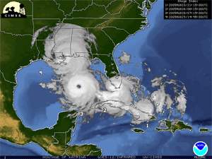
A team of atmospheric scientists led by CIMSS ’s James Kossin recently improved the consistency of the hurricane record for the last two decades. Looking at the revised dataset, they uncovered evidence to support the theory that global warming has had an impact on hurricanes in the Atlantic Ocean. The trend does not hold up in the other oceans across the globe.
A recent study provides scientific evidence that hurricanes have become stronger and more frequent in the Atlantic Ocean over the last two decades. The increasing trend, however, does not hold true for the world’s other oceans.
Scientists at the University of Wisconsin-Madison and the National Climatic Data Center (NCDC) of the National Oceanic and Atmospheric Administration reported the finding in the journal Geophysical Research Letters.
“The debate is not about scientific methods, but instead centers around the quality of hurricane data,” says lead author James Kossin, a research scientist at UW-Madison’s Cooperative Institute for Meteorological Satellite Studies. “So we thought, “Let’s take the first step toward resolving this debate.’”
Once the NCDC researchers recalibrated the hurricane figures, Kossin took a fresh look at how the new numbers on hurricane strength correlate with records on warming ocean temperatures, a side effect of global warming.
“While we can see a correlation between global warming and hurricane strength, we still need to understand exactly why the Atlantic is reacting to warmer temperatures in this way, and that is much more difficult to do,” says Kossin. “We need to be creating models and simulations to understand what is really happening here. From here on, that is what we should be thinking about.”
— Paroma Basu, UW-Madison Communications
Read the full UW news release.
Several media outlets picked up the story, including the Badger Herald, one of UW-Madison’s student newspapers. The Associated Press also distributed an article about tropical cyclones that mentioned Kossin’s work. This article appeared in over 100 media outlets across the globe.
Satellites’ skewed view of the clouds
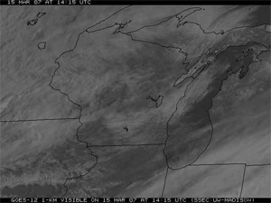
As the number of satellites observing Earth increased, they began to cover smaller areas with a narrower focus. According to a research team led by CIMSS’s Amato Evan, the change in viewing angle caused clouds viewed by satellites to appear smaller. This satellite image shows clouds over the midwest on March 15.
The large decrease in the amount of clouds covering the Earth likely results from a change in satellites’ perspective, according to research by CIMSS’s Amato Evan,Andy Heidinger(NOAA at CIMSS) and another UW-Madison atmospheric scientist, Dan Vimont.
Scientists noticed decreasing global cloud cover in a record compiled over several decades by the International Satellite Cloud Climatology Project (ISCCP)—a trend linked to global warming and climate change. Evan and his team reported evidence against this trend in a paper published in Geophysical Research Letters for March 2007.
Evan and his team observed that global cloud cover decreased abruptly when the number and positions of weather satellites changed. According to Evan, the increased number of satellites in the 1980s and 1990s meant that each satellite could narrow its field of view, allowing satellites to look straight down at a smaller area instead of at an angle. The change in viewing angle causes clouds to appear smaller.
“It’s not getting less cloudy on Earth,” a Nature online article quotes Evan. “It looks like it is [from the ISCCP data] but it’s not.”
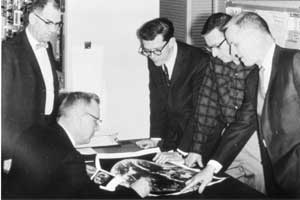
Verner Suomi (seated) and Robert Parent (standing behind Suomi) look at early photos from their Spin Scan Cloudcover Camera, which flew on ATS-I, the first geostationary satellite. Known as the “Father of Satellite Meteorology,” Suomi changed the way we observe and understand the weather.
An online podcastrecently honored SSEC’s co-founder, Professor Verner Suomi. Known as the “Father of Satellite Meteorology,” Suomi changed the way we see the weather.
WeatherBrains, a weekly webcast for weather lovers, included a tribute to Suomi in the February 19 episode. The story featured interviews with SSEC’s Director Hank Revercomb, Paul Menzel and Tom Achtor.
“[Suomi] was one of the very first people that saw the potential for satellite remote sensing of the planet,” Menzel says.
Reporter David Black explained the concept of Suomi and colleague Robert Parent’s spin-scan cloud camera, and how the camera inspired a revolution in meteorology.
Black also mentioned that Suomi and Parent created SSEC to be “a think tank …an invention hotbed.” Black also mentioned SSEC’s plans to build an atmospheric and space science museum in Suomi’s honor.
Revercomb says that he remembers Suomi as a man “who was always thinking [and] looking for new approaches to new things.”
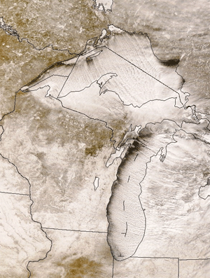
According to Scott Bachmeier, the cold air of late January and early February mixed with the relatively warm waters of the Great Lakes to produce lake-effect snow. This satellite image clearly depicts the snow blanketing the midwest.
This year Madisonians have experienced a winter of extremes: unusually warm weather followed by unusually cold weather and topped off with a record-breaking blizzard. A couple of SSEC’s fonts of weather trivia, Scott Bachmeier and Scott Lindstrom, provided a running commentary of this winter’s record-setting weather.
From December 9 to January 8, Bachmeier noted, Madison had 31 consecutive days with temperatures reaching or exceeding 32 degrees. According to Bachmeier, this string breaks the previous record of 29 days, which occurred during the winter of 1889-90.
As winter wore on, Lindstrom noticed quite a different trend. For 20 days, from January 28 through February 16, temperatures in Madison did not exceed 23 degrees. Only six similar cold streaks have occurred since the city starting keeping weather records in 1869.
In late February, almost 16 inches of snow blanketed Madison over three days. Lindstrom reported that this storm is the first on record during which more than four inches of snow fell on three consecutive days. Lindstrom also noted that the snow had a high percentage of water, making it heavier that the typical Madison snowfall. Lindstrom explained the heavy snow in an article for the Wisconsin State Journal on February 26.
David Medaris of Isthmus, a local newspaper, posted Lindstrom and Bachmeier’s observations on the paper’s website in an entry on February 22and an entry on February 26. The Capital Times mentioned the blizzard record in an article printed on February 27.
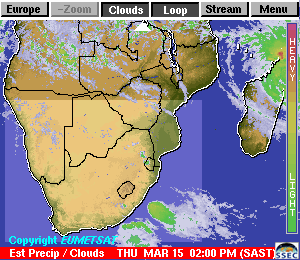
SSEC’s PDA Animated Weather (PAW) service now includes products for South Africa.
PAW adds South Africa products—SSEC’s popular PDA Animated Weather service, known as PAW, recently expanded to include products for southern Africa.
After creator Russ Dengel demonstrated the PAW service for Philip Frost, visiting scientist from South Africa’s Meraka Institute, Frost asked Dengel if he could add southern Africa to the PAW’s coverage. Based on Frost’s interests, Dengel initially included satellite images and data to identify locations of wild fires. Dengel also added information about the path of a hurricane as it loomed off the continent’s coast.
“Our interest is to develop and distribute tools that can provide information to the general public,” Frost said in an internal news release from the Meraka Institute. The release commented on SSEC’s “dedication, innovation and willingness to share this technology.”
Saharan dust and Atlantic hurricanes—The February 7 issue of theWisconsin Engineer published a story about Amato Evan and Andy Heidinger’s research on the effects of dust from the Sahara on hurricanes in the Atlantic Ocean. The Herald Tribune, a newspaper in Florida, ran a similar story. “There might be kind of a threshold where you pump enough dust over the ocean and you are really going to kill the hurricanes,” the article quotes Evan.
In October, Geophysical Research Letters published Evan and Heidinger’s paper discussing the correlation between the intensity of dust storms in the Sahara Desert and the intensity of hurricanes in the Atlantic.
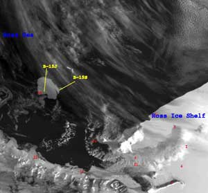
Scientists with AMRC noticed that three pieces had broken off of one of the icebergs in the Ross Sea. One of these pieces was large enough to receive a name.
Iceberg discovery—During the week of March 6, the Earth Observer, an online newsletter from NASA, featured an image of a recently formed iceberg in Antarctica. Scientists with SSEC’s Antarctic Meteorological Research Center (AMRC) spotted this iceberg on February 1. At a little over 11 miles in length, this iceberg is big enough to receive a name—B-15S.
Comments on future polar-orbiting satellite system —The Antarctic Sun interviewedAMRC’s Matthew Lazzara about the upcoming National Polar-orbiting Operational Environmental Satellite System (NPOESS) for an article published on February 4. Lazzara commented on the benefits of NPOESS to Antarctica’s McMurdo Station. “The big benefit of NPOESS [to McMurdo] will be this communication capability that’s added to the station,” the article quotes Lazzara. The article also mentions AMRC’s research and theAutomatic Weather Station program.
Mars warming —Amato Evan commented on a controversial theory in a recent article in National Geographic. The article is about a Russian scientist who implicates natural rather than anthropogenic causes in global warming by linking warming trends on Mars with those on Earth. “The idea just isn’t supported by the theory or by the observations,” said Evan.
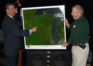
Russ Dengel (right) presented Senator Russ Feingold (left) with a MODIS image of Wisconsin at the Senator’s birthday celebration on March 4.
Birthday present for a senator—At Wisconsin Senator Russ Feingold’s birthday party in Madison on March 4, Russ Dengel gave Feingold a high resolution satellite image of Wisconsin created using data processed at SSEC. According to Dengel, Feingold said he would “find a prominent place in the office for it.”
Recently published papers —SSEC scientists contributed to two papers featured in the research highlights sections of NASA’s Earth Observer.Iliana Genkova was the primary author for “Cloud-Top Height Comparisons from ASTER, MISR and MODIS for Trade Wind Cumuli.”Bryan Baum, Mike Pavolonis (NOAA at SSEC), Andy Heidinger(NOAA at SSEC) and Rich Frey all contributed to “Comparison of MISR and MODIS Cloud Top Heights in the Presence of Cloud Overlap.” Both papers appeared in the March 2007 edition of Remote Sensing of Environment, an interdisciplinary journal published by Elsevier.