Monthly News Summary – July 2006
Changing the GOES line-up
 |
|
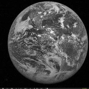
Above is the first full disk image from GOES-13. The Data Center at the Space Science and Engineering Center received this image on June 22.
|
A handful of United States geostationary weather satellites stand sentinel in the sky over the western hemisphere, gathering information about the Earth and its atmosphere. In late June, these satellites underwent a few changes. Facilitated by our Data Center, SSEC has participated in the changes to the GOES line-up.
On June 22, the Data Center began receiving data from GOES-13. Launched on May 24, GOES-13 is the first of the next series of geostationary weather satellites. These satellites will provide a few improvements over current GOES satellites, including improved navigation and superior measurement of optical radiation.
However, we will have to wait to benefit from GOES-13 data. After NASAand NOAA check the satellite both from an engineering perspective and a science perspective, GOES-13 will go into in-orbit storage until it is time to replace one of the current operating geostationary weather satellites (GOES-11 or GOES-12).
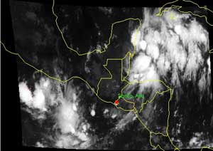
 |
|
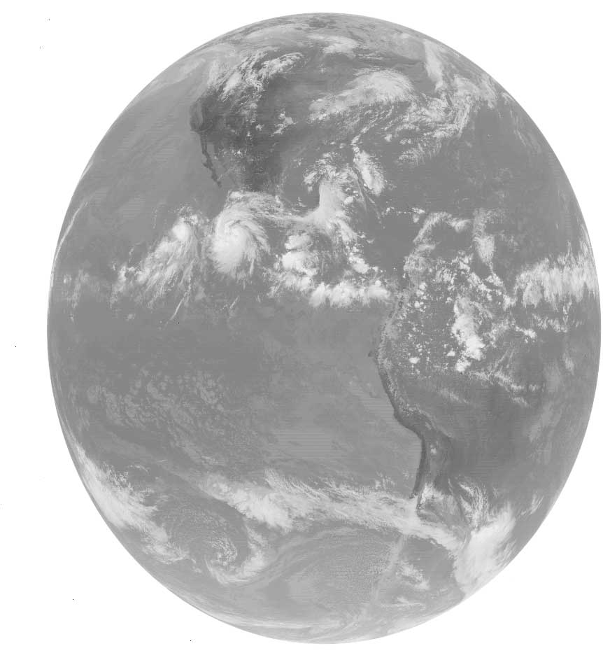
Above is the first infrared image from GOES-13. The Data Center received this image on July 12.
|
When NASA completes the engineering test, NOAA will take over the operation of GOES-13 and will conduct a science test (beginning in the fall). As they have for previous GOES satellites, SSEC’sCooperative Institute for Meteorological Satellite Studies(CIMSS) will contribute to the GOES-13 science test. The test includes comparisons of data from GOES-13 against measurements from other satellites and ground-based instruments. This is a critical step in preparation for the use of GOES-13 data in numerical weather prediction and other forecasting applications.
Also, on June 21, GOES-11 returned to operational use after its own extended hiatus in in-orbit storage. GOES-11 replaced GOES-10 as the GOES-West satellite. GOES-10 will then move to 60 West where it will become the weather satellite over Latin America. SSEC will help with the GOES-10 check-in/check-out as it transfers from the U.S. to Latin America.
 |
|
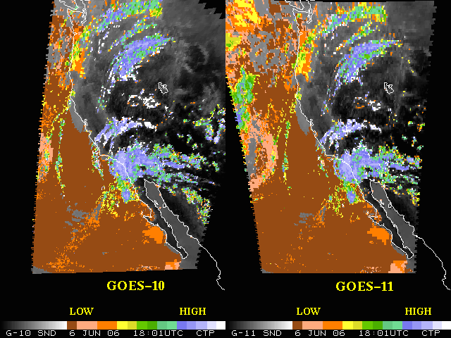
The Cloud Top Pressure products generate for GOES-10 and GOES-11 are quite consistent.
|
SSEC also helped verify the accuracy of GOES-11 as it went through pre-operational tests. In late May and early June, CIMSS researchers compared data from the GOES-11 sounder to that from GOES-10 and found that measurements from GOES-11 showed less noise. After processing the data for the Cloud Top Pressure product, researchers found that GOES-10 and GOES-11 are quite consistent with each other. An initial comparison of data from the GOES-11 imager with observations from the Atmospheric Infrared Sounder (AIRS) was also favorable. SSEC’s Data Center provided all of the data used in these analyses.
 |
|
SSEC recently installed an Online Weather Looper (OWL) display outside of Dean Cadwallader’s office in Bascom Hall.
|
An OWL in the Grad School —In early June, SSEC installed another Online Weather Looper, or OWL, on the UW-Madison campus. The first OWL is in the lobby of the Atmospheric, Oceanic & Space Sciences building. The new OWL perches outside of Dean Martin Cadwallader’s office in Bascom Hall. Cadwallader is UW-Madison’s Dean of the Graduate School and Vice Chancellor for Research. The 32” screen displays a variety of current weather data, imagery and animations. A variety of SSEC personnel installed the OWL. Several members of the center’s technical computing staff provided technical support while others programmed and designed the products for the OWL, and still others procured and installed the system. Together, the crew set up another highly visible OWL to help visitors and staff at the Graduate School understand how satellite data applies to research about many aspects of the weather.
Cloud climate milestone achieved —An effort to reprocess data from a satellite instrument recently reached a milestone. In this project, researchers hope to reanalyze approximately 25 years of climate data gathered by the Advanced Very High Resolution Radiometer (AVHRR), an instrument aboard a polar-orbiting space craft. Recently, a team led by Andy Heidinger (NOAA at SSEC) completed a climatology of clouds in the upper troposphere using temperature and emissivity measurements from AVHRR. The climatology is consistent with climatologies of the tropsphere created with other instruments, and with data from another satellite instrument called the MODerate-resolution imaging Spectroradiometer.
Hurricane image —The Lions of Florida magazine featured an image of Hurricane Wilma on the cover of the May edition. Liam Gumley (CIMSS) created the image. The Lions of Florida used the same image on the cover of their 2006 hurricane guide.
SSEC imagery used on meteorologist’s Web site —New England area meteorologist Todd Gross plans to use SSEC satellite imagery on his Web sites toddgross.com and capeandislandsweather.com. On July 13, Gross used on of SSEC’s MODIS images of weather over the Atlantic Coast. The sites also feature a link to SSEC’s images from polar orbiting satellites. “Thank you once again, I have been aware of your graphics since going toSUNY Albany back in the mid 70s, and 30 years later you are still a leader in the field,” Gross said in an e-mail.
Blogging about tropical cyclones —The animations produced by CIMSS’s Tropical Cyclones research team are “hypnotic,” according to blogger Charles Rigg. Rigg maintains a blog for Wells Fargo called “Guided by History: Communities Respond to Natural Disasters.” In a post on June 6, he wrote about hurricanes and included a link to the Tropical Cyclones research team’s Web page. “As science marches on, we know more things and can study them in very cool ways,” Rigg wrote.
Polar winds product added to forecast system —On June 22, Meteo France became the ninth operational weather center to incorporate MODIS polar winds information into an operational forecast system. Developed by a team of CIMSS researchers led by Jeff Key (NOAA at SSEC), the MODIS polar winds product uses satellite data to calculate the speed, height, and direction of winds in Earth’s polar regions. So far, the addition of the polar winds product to forecast systems has had a positive impact, particularly in polar and extratropical regions.
 |
|
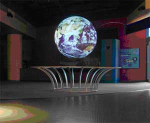
Science on a Sphere features atmospheric data wrapped around a sphere. Above is the sphere at the National Maritime Center’s Nauticus museum.
|
Science on a Sphere—On June 13, the New York Times ran an article about Science on a Sphere, a large suspended sphere that displays environmental processes. SSEC was one of three institutions awarded a joint grant to develop educational applications for Science on a Sphere. Titled “Video Projections on a Globe Make Planetary Data Click,” the New York Times article details how Science on a Sphere operates and how it helps museum-goers learn about the earth and other planets.
Meetings and Field Experiments
Polar workshop—Several Antarctic research groups convened in Boulder, CO for the Antarctic Meteorological Observation, Modeling and Forecasting Workshop. From SSEC’s Antarctic Meteorological Research Center (AMRC), Shelley Knuth helped organize this workshop, which brought together groups that usually hold separate annual meetings. Knuth also gave presentations on the icebergs in Antarctica during 2005-06, and icebergs and the inverse barometer effect. Also from AMRC and Automatic Weather Station (AWS) program, Matthew Lazzara, Charles Stearns,George Weidner and Linda Keller (AOS) presented on a variety of topics.
AIRS science—Bob Knuteson (CIMSS) and Hank Revercomb(SSEC) participated in the Atmospheric Infrared Sounder (AIRS) science team meeting held in Pasedena, CA on March 7-10. In an article about the meeting, NASA’s Earth Observer mentioned Knuteson and Revercomb’s contributions. Knuteson explained his use of data from the Atmospheric Radiation Measurement program’s Southern Great Plains site to validate AIRS temperature and emissivity measurements. Revercomb discussed the use of data from the Scanning High resolution Interferometer Sounder (S-HIS) to validate AIRS radiances.
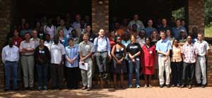 photo courtesy of Paolo Antonelli photo courtesy of Paolo Antonelli |
|
45 students participated in SSEC’s remote sensing workshop in Pretoria, South Africa.
|
International workshop—
Dedicated to educating current and future generations of scientists on the role satellite data can play in observing the Earth, SSEC sends researchers around the world to present workshops about the principles and applications of remote sensing. Through lectures and interactive labs, participants gain the knowledge necessary to continue exploring Earth’s atmosphere via satellite technology. SSEC has conducted several international remote sensing workshops, including a recent trip to South Africa.
From April 3-7, four SSEC researchers and a technical support guru traveled to Pretoria, South Africa to explain and demonstrate to 45 students the use of satellite products generated with data from the MODerate-resolution Imaging Spectroradiometer (MODIS) and the Atmospheric InfraRed Sounder (AIRS). Using software developed at SSEC, students also applied these products to regionally relevant satellite data during lab sessions.
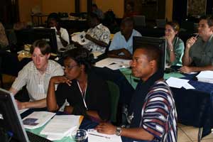 photo courtesy of Paolo Antonelli photo courtesy of Paolo Antonelli |
|
In addition to lectures, the students participated in hands-on labs that allowed them to manipulate regionally relevant satellite data.
|
CIMSS senior scientist Allen Huang introduced the workshop with words of encouragement for the students. According to fellow CIMSS researcher Kathy Strabala, Huang told the story of his “meager beginnings” coming to the U.S. without knowing English and how he developed as a scientist. “His message to the students was that ‘this could be you too,’” Strabala says. Huang’s speech set a tone of hope and excitement that the students and their instructors sustained throughout the workshop.
Because the workshop participants came from a variety of educational and professional backgrounds, Paolo Antonelli (CIMSS) opened each day with a lecture that covered relevant principles of remote sensing. A more advanced lecture followed and the students then worked through lab exercises to apply what they learned. “We were geeking out and they were geeking out,” Strabala says. “Being able to see someone get so excited about [satellite data] is really rewarding.”
|
|
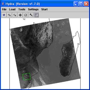
Workshop participants used HYDRA to carry out exercises during the lab sessions. |
In of the lab sessions, the workshop organizers sought to give the students with a practical understanding of MODIS instrument characteristics and the ability to create high resolution images using MODIS data. This lab also helped familiarized workshop participants with the Hyperspecteral-viewer for Development of Research Applications (HYDRA), a software program developed at SSEC to facilitate the use of satellite data. During the lab, students carried out several exercises to practice what they learned. Throughout the workshop, the students participated in other labs that centered on various satellite data products and several techniques with which to manipulate the data.
The workshop organizers generally received incredibly positive feedback. So far, SSEC has given two in China, one in Taiwan, one in Australia, one in Norway and the most recent in South Africa. This recent workshop includedAllen Huang, Liam Gumley, Kathy Strabala, Paolo Antonelli, andTom Rink (all affiliated with CIMSS).
Papers
The AMRC/AWS team at SSEC contributed to several papers included in the booklet for the Antarctic Meteorological Observation, Modeling and Forecasting Workshop. Shelley Knuth and Matthew Lazzara co-authored “A Dynamical Investigation of the May 2004 McMurdo Antarctica Severe Wind Event” with researchers from Ohio State University. George Weidner, Jonathon Thom, and Knuth assembled “A Review of the AWS 2005-06 field season.” Charles Stearns, Knuth and Lazzara wrote a report on the “Status of AMRC 2005-06.” Lazzara also contributed to “The South Pole Meteorological Comparison and CLIMAT Message Projects.”William Straka (CIMSS), Jeff Key (NOAA at SSEC), Dave Santek(CIMSS), Liam Gumley (CIMSS), Kathy Strabala (CIMSS) and Lazzara wrote “Satellite-derived Wind, Cloud, and Surface Products at Direct Broadcast sites in the Antarctic and Arctic.”
The June issue of the Journal of Geographic Research included a paper byAmato Evan (CIMSS) and Andy Heidinger (NOAA at SSEC) about a recently-generated dust climatology. Evan and Heidinger created the climatology using data from the Advanced Very High Resolution Radiometer (AVHRR) as a part of the Pathfinder Atmospheres Extended (PATMOS-x) project. They verified the dust climatology against observations from NASA’s Aerosol Network and with other climatologies that span shorter time frames. The data set is now a part of a study of the effects of dust on hurricanes.
Spaceflight expertise—A Milwaukee-based company has enlisted SSEC for assistance in developing and testing potential satellite technology. Brad Rake, founder of Esker Technologies, invented Zerowire—a concept that eliminates the need for an independent set of wires devoted to communications and control elements in DC voltage electrical systems. The Department of Defense awarded Rake a grant to determine if Zerowire can work on a satellite. SSEC and the Air Force will collaborate with Rake as a part of this grant. “I don’t have any space experience, so that’s why we partnered with UW,” Rake said in an article posted on the Wisconsin Technology Network on June 7. The article included a link to SSEC’s home page.
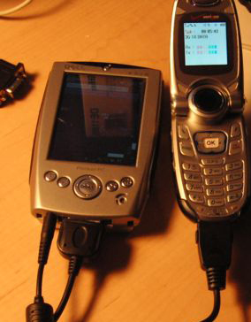 image courtesy of Dave Rarrick image courtesy of Dave Rarrick |
|
A police officer from Ohio uses his cell phone to connect his PDA to the internet, allowing him to use the PAW while on patrol.
|
A police officer inRavenna, OH began using SSEC’s PDA Animated Weather (PAW) servicewhile on patrol. According to Officer Dave Rarrick, Ravenna receives a lot of severe weather during the summer months. With a bit of guidance from Russ Dengel (SSEC), the PAW’s creator, Rarrick figured out how to use his cell phone to connect his PDA to the internet. “This is great for on the move weather watching!” Rarrick said. Rarrick also plans to use the PAW on an upcoming motorcycle vacation.
During June, Dengel also added a new product to the PAW suite. Users can now access daily true color images from the Moderate Imaging Spectrometer (MODIS), a type of instrument aboard satellites in NASA’s Earth Observing System.
Aviation applications for satellite data—Two articles published in June highlighted and praised the efforts of the Advanced Satellite Aviation weather Products (ASAP) project, which fosters the use satellite data to support the aviation community. Researchers at several institutions have collaborated on this project, including NASA, the Federal Aviation Administration, and UW-Madison.
 |
|
Michael Pavolonis used satellite data to detect and study volcanic ash, which can be a flight hazard.
|
The May-June edition of NASA’s The Earth Observer featured a long article about ASAP and its ambitions to enable the Next Generation Air Transportation System. A central aspect of this endeavor is the improvement of the detection, characterization and forecasting of weather phenomena that affect air traffic. The article says the project bridges “the worrisome gap that so often exists between research and operations.” SSEC researchers Wayne Feltz (CIMSS), Kris Bedka (CIMSS), Tony Wimmers (CIMSS) and Michael Pavolonis (NOAA at SSEC) appeared in the article. Feltz and Bedka’s work centers on using products derived from satellite data to improve predictions of convective weather as well as severe winter storms. Wimmers leads ASAP research on the use of sounders on satellites to detect clear air turbulence, which is responsible for the most injuries on commercial flights. Wimmers and his team developed techniques to identify atmospheric characteristics that contribute to turbulence. Pavolonis used satellite data to detect and study another flight hazard—volcanic ash.
The Milwaukee Journal Sentinel also published an article about ASAP. Titled “Under Watchful Eyes,” the article ran on June 4. Reporter Harvey Black interviewed Feltz and Pavolonis. In the article, Feltz touts the project as “innovative” because the research will help make the use of satellite data in aviation applications “routine and automated.” John Mecikalski, a researcher with the University of Alabama-Huntsville, explained that satellite data facilitates earlier detection of thunderstorms. The ability to accurately predict possible areas of storm development will lead to more efficient air traffic control. Pavolonis helped readers understand how his technique helps researchers distinguish volcanic ash clouds from developing thunderstorms. Satellite data can tell the difference between the two because ash and water vapor interact differently with infrared energy emitted from the earth. Pavolonis’ technique also determines how high an ash cloud is, which helps forecast where the winds will take it.
Both articles stress the importance of the ASAP research. The Earth Observer piece emphasizes ASAP’s role in improving aviation weather information for the Next Generation Air Transport System. This article also cites ASAP as an excellent example to justify investing in multi-million dollar research satellites. Black’s article in the Milwaukee Journal Sentinelfocuses on how ASAP research benefits commercial aviation and, consequently, consumers. As Feltz said in Black’s article: “We hope that this system will become operational in the next one or two years.”
Adding weight—In early June, Mat Gunshor (CIMSS) created a Web page for real-time GOES weighting functions. To measure the energy emitted from the earth, GOES satellites have bands or channels that gather information about different portions of the electromagnetic spectrum. In a general sense, weighting functions provide information about different layers of the atmosphere based on the type of radiation measured in that layer. Using weighting functions, one can determine the vertical contribution of the radiation measured by each channel. After SSEC featured the site as aspotlight, it became the first site found in a Google search for “GOES weighting function.”
Tours galore! —Several tour groups visited SSEC during late May and June. Many of these groups were from the Urban Adventure program, which came to fruition through collaboration between UW-Madison and Madison public schools. The urban adventurers were fourth and fifth graders. Another set of elementary school tour groups was with College for Kids, a program for Dane County’s soon-to-be sixth graders. These inquisitive kids explored the roof, learned about Antarctic meteorology, found out about weather satellite data in the lobby, and questioned a variety of scientists about everything from satellite imagery to office paper clutter. SSEC’s high school visitors were from the Pre-college Enrichment Opportunity Program for Learning Excellence (PEOPLE). SSEC’s Office of Space Science Education coordinated a PEOPLE workshop hosted by SSEC. Bob Aune (NOAA at CIMSS), Tony Wimmers (CIMSS) and Shelley Knuth (AMRC) hosted a group on June 20. Tour coordinator Margaret Mooney (SSEC) reported that “two students gave me a high five as they were leaving SSEC … with big smiles on their faces.” According to Mooney, the students particularly enjoyed their experience at the center. Another PEOPLE group, hosted by Tim Schmit (NOAA at CIMSS), came to SSEC to learn more about weather satellites—particularly the use of satellite data to research and forecast hurricanes.
Praise for service—SSEC Web presence received a huge complement from Alan Height. “What you have given the public is a much broader perspective of themselves and their surrounding area,” Height wrote in an e-mail. “To see the entire planet and the whole weather system as one, tells me the thunderstorm overhead is a drop in the bucket. I now have a whole new perspective.”
Eclipse animation—David Makepeace, the Eclipseguy, appreciated SSEC’s animation of the solar eclipse on March 29, which Rick Kohrs(SSEC) created. “Excellent job with this animation,” Makepeace wrote. “Congrats to Rick and SSEC for making this available.
But it is rocket science!—The Exchange, a publication for the scientific communications group in the Society of Technical Communicators, included an article by Terri Gregory (SSEC) in its December 2005 edition. In the article, Gregory describes her experiences as SSEC’s public information coordinator. “Our job is getting the word out—seeing that the SSEC is visible to the general public and other audiences,” Gregory wrote. Her greatest challenge has been writing pieces to engage and inform multiple audiences but still maintain the scientists’ expectations of precision. Although many of SSEC’s funding agencies require some element of public outreach, Gregory reported that she has “still needed to pull teeth to get the Center’s most important work into the public’s eye.” In the article, Gregory explained that much of the work done at SSEC is either abstract or esoteric or both. “What we have going for us is the fact that everyone talks about the weather, and many people love gadgets,” she wrote. Gregory concluded that SSEC’s work shouldn’t be “as difficult for the public to understand as it is for our researchers to do.”
Bike to Work Week—Several SSEC employees faithfully participated in Madison’s Bike to Work Week challenge from May 15-18. Despite inclement weather, SSEC logged 32 round-trip bicycle commutes. Sarah Bedka (CIMSS), William Straka (CIMSS), Jean Stover (SSEC) and Eric Wall (SSEC) biked to and from work every day of the challenge in spite of harsh winds and rain.