Monthly News Summary – May 2006
High resolution workshop attracts international interest
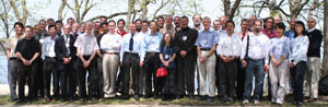 image courtesy of Paolo Antonelli image courtesy of Paolo Antonelli |
|
SSEC hosted the third annual Advanced High Spectral Resolution Infrared Observations Workshop. 50 scientists from six countries and 16 institutes attended.
|
Fifty scientists from six different countries and sixteen research institutes converged on Madison, WI for the third annual Advanced High Spectral Resolution Infrared Observations Workshop. The Space Science and Engineering Center hosted the workshop at UW-Madison’s Friedrich Center on Lake Mendota’s shore from April 26–28. Attendees were treated to near perfect Wisconsin spring weather in an idyllic lakeside setting. Presentations given during the workshop are posted on the workshop’s web site.
SSEC organizes this annual workshop so that researchers new to this esoteric subject matter can learn from those more acquainted with the field. It also provides an opportunity to share engineering and scientific news and progress. Sessions devoted to the capabilities and requirements of new instruments elicited many questions and proffered new useful information. Those dealing with the Infrared Atmospheric Sounding Interferometer (IASI) and the Geosynchronous Imaging Fourier Transform Spectrometer (GIFTS) were particularly productive. Many scientists who attended the workshop contribute substantial input to the development of weather instruments used by meteorological agencies worldwide as well as techniques to exploit data from those instruments, so the workshop facilitates access to a wealth of experience and information.
IASI the sounding instrument on EUMETSAT’s first operational polar-orbiting weather satellite, is approaching launch and the instrument has passed all its tests. Researchers eagerly anticipate the data, which will be very accurate (temperature accuracy for data of 1 km resolution will be 1 Kelvin, within 10% for humidity). With spectral capability almost four times that of the Atmospheric InfraRed Sounder, the IASI will provide new information about clouds and trace gases.
|
|
|
Hank Revercomb (left) gave an overview of GIFTS including the current status of the instruments.
|
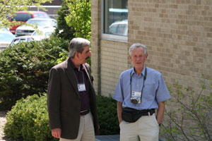
The Space Dynamics Lab (SDL), with support from NASA and NOAA, has completed a preflight version of theGeosynchronous Imaging Fourier Transform Spectrometer (GIFTS). Co-investigator Hank Revercomb (SSEC) introduced the instrument and itemized current instrument status. SDL, he said, has experience creating interferometer instruments. He emphasized this instrument’s unique internal calibration system, with blackbodies designed and constructed at SSEC. He and William L. Smith, GIFTS principal investigator, voiced what many researchers are thinking—GIFTS must fly! According to Revercomb, the instrument is necessary as part of a comprehensive testing program for the next generation GOES satellites. He noted that, because the instrument represents such a huge step technologically, everyone “will benefit if we can fly GIFTS and get it to a point where we can learn something.” The National Research Council’s Decadal Survey Interim report to congress said that GIFTS should be flown by 2008. Both Revercomb and Smith say it can be done.
Other key points from the meeting include:
Principal Component Analysis has been proved to be an extremely powerful diagnostic tool for high spectral resolution infrared instruments.
For absolute calibration, we need to measure differences of a tenth of a degree Kelvin. This level of calibration is important for climate studies. Very careful characterization and validation is important both before and after launch.
|
|
|
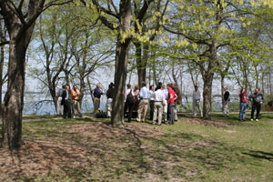
During breaks, workshop participants enjoyed the paths by Lake Mendota.
|
Foreign government, and U.S. corporate, federal and university institutions represented at the workshop included Moscow’sScientific Research Center Planeta, theEuropean Centre for Medium-Range Weather Forecasts,EUMETSAT, UK’sMet Office, Centre National d’Etudes Spatiales, the University of Oxford, Ball Aerospace, Atmospheric and Environmental Research (AER), Inc., Utah State University’s Space Dynamics Laboratory, NOAA’sNational Environmental Satellite, Data, and Information Service, and several other groups.
The “International Hyperspectral Forum” was established near the end of the workshop to foster the exchange of information, data and ideas among the members of the hyperspectral community. The usefulness of the forum will be verified over the next few months. It is hoped that researchers with all levels of experience will continue the discussion, particularly those new to the field.
—Terri Gregory
 |
|
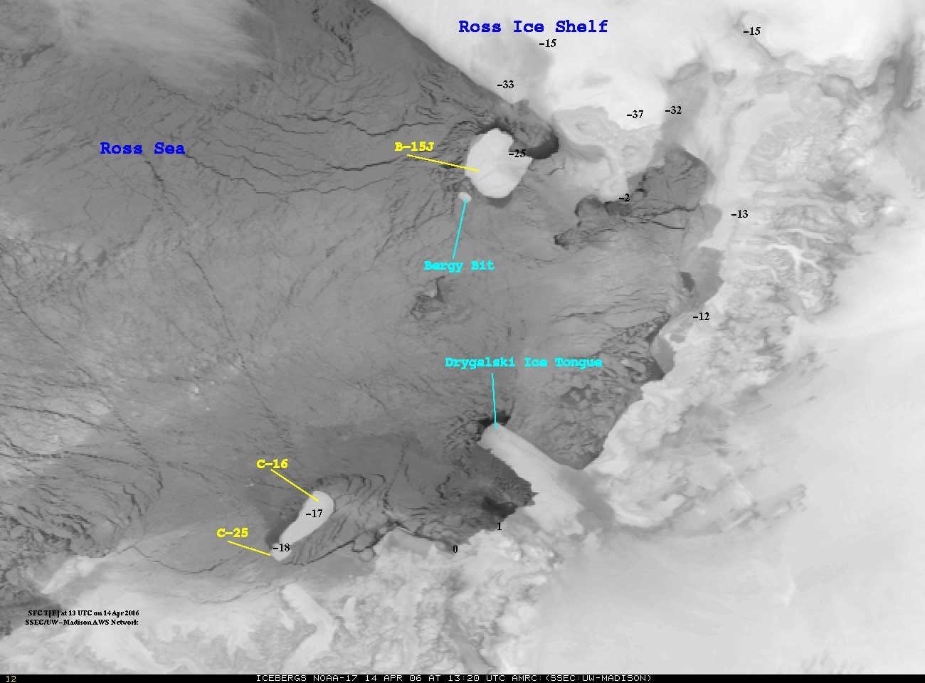
Researchers at SSEC’s AMRC monitored the movement of iceberg C-16 as it chipped off the tip of the Antarctica’s Drygalski Ice Tongue.
|
Iceberg!—In late March, iceberg C-16 plowed past Antarctica’s Drygalski Ice Tongue on the Scott Coast and SSEC’s Antarctic Meteorological Research Center (AMRC) monitored its progress via weather satellite imagery. On April 19, CNN’s international meteorologist Femi Oke interviewed meteorologist Shelley Knuth (AMRC/AWS), and played a movie (produced by Knuth andJonathan Thom) showing C-16 knocking off the tip of the Drygalski Ice Tongue. Knuth, who monitors icebergs and meteorological phenomena for the AMRC, was interviewed live for Oke’s special CNN segment called “Changing Earth” that looks at new developments in the world of science. As the movie played and a slide show of photos by the Antarctic Sun’s Emily Stone flash across the screen, the interview was simulcast on CNN and CNN International. For a day or two the iceberg movie was the most watched of all videos on the CNN Web site.
In the Wisconsin State Journal for Sunday, April 9, David Wahlberg’s science column featured the iceberg’s collision (scroll to the middle of the article to read the piece about the iceberg). NASA’s Earth Observatory web site used Goddard Space Flight Center’s spectacular MODIS imagery to show the collision, and noted the AMRC’s research. Knuth appeared on WORT-FM’s 8 O’Clock Buzz on Friday, April 7. Listeners called in with alternative names for C-16, named by the National Ice Center in accordance with established rules. A couple of the more imaginative names proposed for C-16 were Zarov, after the show’s similarly unpredictable host, and lettuce.
Polar winds in operational models —Two Moderate Resolution Imaging Spectroradiometer (MODIS) Direct Broadcast sites generate polar winds information. Developed by a team of CIMSS researchers led by Jeff Key(NOAA at SSEC), the MODIS polar winds product uses satellite data to calculate the speed, height, and direction of winds in Earth’s polar regions. Last month, the Fleet Numerical Meteorology and Oceanography Center(FNMOC) within the United States Navy began using the polar winds product generated at the direct broadcast site at McMurdo, Antarctica. In mid-April, FNMOC also started using the polar winds produced at the site in Tromsø, Norway, which first generated the product using direct broadcast data last month. FNMOC incorporates the MODIS polar winds product into the Navy Operational Global Atmospheric Prediction System(NOGAPS). Direct broadcast products are available sooner and allow more data to be included in forecast model runs. After deciding on a method for distribution, more weather prediction centers plan to use direct broadcast polar winds in forecast models.
Providing background—Although not directly quoted, Tom Achtor(SSEC) provided background information for an article titled “Weather Satellite to Monitor South America.” Associated Press reporter Lauren Smiley explained how NOAA plans to reposition an “aging but reliable” former United States satellite so that it looks down on South America. ABC news posted the article on April 17.
Nova, Dimming—In late April, the PBS television science program Novaaired “Global Dimming,” a program about the possible effects of clouds, primarily contrails, on climate. UW-Whitewater geography professor and administrator David Travis came to UW-Madison’s Atmospheric, Oceanic and Space Sciences building for some verisimilitude. The BBC crew taped Travis talking about contrails from the building’s roof and in the SSEC Data Center, from whom Travis has acquired some satellite data. The program used information from scientists around the world including NASA’s climate expert James Hansen.
Hot-water drill aids IceCube progress —Working with IceCube, SSEC’s Ice Coring and Drilling Services participated in the development and construction of the Enhanced Hot Water Drill. Using the hot-water drill, IceCube made significant progress on their neutrino observatory in Antarctica. On March 21, coordinating with UW-Madison’s Office of Communications, the National Science Foundation published a media advisory with the details of progress on the observatory. The NSF advisory refers to the “sophisticated hot-water drill” used by IceCube to “install hundreds of basketball-sized optical modules in the South Pole ice sheet.” Images of the drilling equipment accompany the advisory.
Over the last month, Russ Dengel introduced two new features to his PDA Animated Weather (PAW) service. He also implemented a couple of strategies to improve existing products and tools. Now funded throughCIMSS, the service continues to gain popularity and Dengel will continue add new features as needed.
 |
|
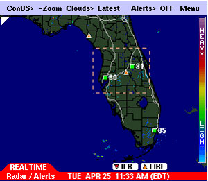
The triangles with orange centers indicate confirmed and likely fire sites.
|
In April, Dengel worked with CIMSS’s Elaine Prins and Chris Schmidtto add a product that uses satellite data to monitor fires. Triangles with orange centers indicate locations of confirmed and likely fires. Users can superimpose this product over all real-time radar products. In the next month, fire locations will also be plotted over IR Cloud products.
Dengel also added a feature to display information for pilots flying in low visibility conditions. Instrument Flight Rules help pilots avoid obstacles and other air traffic. The markers are plotted over the high resolution radar animations.
While adding products and information, Dengel also refined the New England, East Coast, Ohio River Valley and Gulf Coast regional radarproducts. He eliminated a significant level of clutter caused by overlapping tile boundary graphics while providing the illusion of a seamless +ZOOM region.
With the help of Bob Rabin (CIMSS), Dengel replaced the Storm Total Precipitation images available on the PAW site with high resolution precipitation grids from the National Severe Storms Laboratory. Rabin uses McIDAS to generate images based on NSSL data every 15 minutes. Dengel made the images accessible through the PAW site.
 |
|
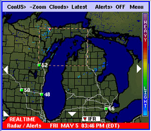
Dengel added a new radar sector for northern Michigan in response to a request from a boater.
|
In response to a request from a boater in Michigan, Dengel recently added a new radar sector for northern Michigan. Dengel continues to accommodate requests and to address feedback from PAW users, making this service increasingly valuable.
Next month, a monthly sailing magazine will feature an article about the PAW service. “This is the smartest collection of weather products that I have found in seven years,” said Tom Snyder, who will write the article.
Hurricane image use—The French government’s Minister of the Environment and Long-term Development used a hurricane image generated at SSEC in an April publication about environmental research (please note: this links to a PDF). The letter was about censorship of environmental research.
Contributing to a record-breaking season—CIMSS’s Tropical Cyclones team, led by Chris Velden, contributed information that confirmed the 28th cyclone in the 2005 hurricane season. Using data from the Advanced Microwave Sounding Unit (AMSU) aboard NOAA-15, a polar orbiting satellite, the team generated an analysis of the October storm. This analysis led to the National Hurricane Center’s decision to officially label the storm a subtropical cyclone, bringing the total number of storms in the 2005 season to a record-breaking 28.
Linked—NASA’s Hurricane Resource Page now links to the CIMSSTropical Cyclones Web page. Look under Related Links in the right-hand frame.
Documentary appearance—A group producing a documentary on the demise of the electric cars that first appeared in the 1990s has asked to use a Hurricane Lili image. Chris Paine wrote and directed the film, which is scheduled to be released in June by Sony Classics.
Dust!— Collaborating with the Smog Blog folks at the University of Maryland, Baltimore County, Scott Bachmeier of CIMSS’s IDEA Team followed the long-range transport of Asian dust as it made its way across the Pacific, the northern Midwest, and eventually over southeastern Canada and New England by mid- April. You can see the event (and others like it) by going to the IDEA web site and scrolling down a half page to the “48-hour aerosol trajectory forecast, with model winds and precipitation” display. Click on the latest image and then go back in time (to the weekend of April 15 and 16) until a characteristic light blue to yellow enhancement appears off the West Coast, a signature of elevated Aerosol Optical Depth (AOD) caused by the presence of Asian dust.
Concurrently with the big mid-April dust storm, a large multi-aircraft field campaign (INTEX-B) continued in the Pacific Ocean. This campaign is studying such phenomena. These dust outbreaks flare up periodically in the spring, says Bachmeier, and adds, “People don’t realize how globally extensive these events can be.” IDEA researchers do not know if or how the dust affects surface air quality as it moves across the United States—the satellite products reveal the presence of airborne pollution, but provide no information about the exact vertical location of the aerosols. However, INTEX-B aircraft are equipped with lidar, which can help to determine the precise vertical location (and depth) of the layers of Asian dust.
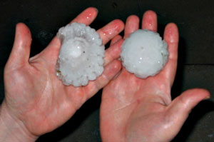 image courtesy of Scott Nolin image courtesy of Scott Nolin |
|
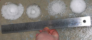
Golf-ball-sized hail pelted the Madison area on the evening of April 13.
|
Hail!—Large hail stones pelted the Madison area on the evening of April 13. TheCIMSS Regional Assimilation System(CRAS), CIMSS’s experimental numerical weather prediction model, forecasted the severe weather at approximately the correct place and time (about 9:30 p.m. CT) in a 13-hour forecast. It is unusual for the CRAS to predict locally intense thunderstorms, but researchers at CIMSS believe that the precipitable water observations from the GOES-12 sounder improved the CRAS’s abilities. CIMSS researchers use the model to determine the impact of GOES sounder products in forecasts of significant weather events.
|
|
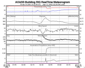
The hail storm attracted the attention of several SSEC employees all over the southern and eastern portions of the Madison area. After comparing notes, hail stones collected and stored, and analyses, our consensus was that golf-ball-sized hail fell on our houses, broke our windows, and shattered our serenity. Grant Petty, a professor in the Department of Atmospheric and Oceanic Sciences in the same building with SSEC, reported interesting observations from the Rooftop Instrument Group: The pressure underwent a four millibar (mb) fluctuation over just a few minutes. In conventional synoptic terms, a pressure change of just two mb over the space of an hour is considered “rapid.”
 |
|
The RIG showed a steady wind that dropped to nearly calm during the event and picked up again afterward.
|
The rooftop suite of instruments also showed that the wind was steady before and after but dropped to nearly calm during the event. About three millimeters of rain was recorded on the roof in just a couple of minutes, so the precipitation rate was briefly very high.
Petty also noted that the hail shower at his home just south of Madison was longer than reported by those of us living north of that—“five minutes or more, but the hailstones were somewhat smaller on average. Only few reached golf-ball size. Even those, however, showed evidence of having melted from a much larger size. For example, concentric layers were visible on one side that had melted away on the other.”
Rusty Kapela of the Milwaukee-Sullivan National Weather Service forecast office noted that people from Iowa County straight across to Milwaukee reported hail stones as big as 4.25 inches across.
Probing the atmosphere—On Friday April 28, a Boeing Delta 2 rocket launched from Vandenberg Air Force Base, CA propelling two satellites into space—Cloud-Aerosol Lidar and Infrared Pathfinder Satellite Observations (CALIPSO) and CloudSat. These satellites will, according to NASA, probe “the earth’s atmosphere to unravel the mysteries of clouds and climate change.” CIMSS director Steve Ackerman is a member of the CALIPSO science team. He plans to work with the data from this satellite. Ackerman also reports that CloudSat scientists intend to use the MODIS Cloud Mask developed at SSEC’s CIMSS. Andy Heidinger (NOAA at CIMSS) will also participate as a member of the CALIPSO science team. He will use CALIPSO data to help refine measurements of cloud properties obtained from passive instruments. This BBC article provides useful information about the mission.
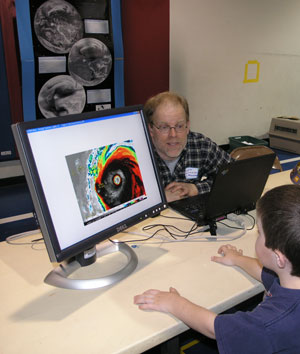 photo courtesy of Ruth Bachmeier photo courtesy of Ruth Bachmeier |
|
Scott Bachmeier showed students and parents satellite imagery at Sauk Trail Elementary School’s science night.
|
‘Tis the season—SSEC researchers are being drawn into school and other public science venues springing up this season. On April 23,Matthew Lazzara of SSEC’s AMRC talked about his work in Antarctica at the Deerfield Public Library in conjunction with a discussion about Susan Solomon’s book, The Coldest March. The Deerfield newspaper,The Independent,announced the event on April 19.
CIMSS researcherScott Bachmeierparticipated in Science Night at Sauk Trail Elementary School in Middleton, Wisconsin on April 19. Bachmeier showed students and parents satellite imagery depicting a variety of phenomena.
Tropical cyclones poster wins award—A poster prepared by Chris Velden (CIMSS), Derrick Herndon (CIMSS), Jim Kossin (CIMSS), Jeff Hawkins (NRL), and Mark DeMaria (CIRA) won an award at the American Meteorological Society’s 27th annual Conference on Hurricanes and Tropical Meteorology. Titled “Consensus estimates of TC intensity using integrated multispectral (IR & MW) satellite observations,” the program committee awarded this poster the one with the “most operational interest.”
CIMSS student has best thesis—The Department of Atmospheric and Oceanic Sciences awarded a CIMSS graduate student the annual award for the best M.S. thesis in the department. Amato Evan’s thesis detailed his research that used data from NOAA’s Advanced Very High Resolution Radiometer (AVHRR) to derive a climatology of Saharan Dust. Andy Heidinger (NOAA at CIMSS) acted as Evan’s research advisor and Steve Ackerman (CIMSS) was Evan’s academic advisor.
Award publicity— Last month, Jean Phillips received a 2006 Academic Staff Excellence Award. Phillips is the librarian in SSEC’s Schwerdfeger Library. The April 19th edition of Wisconsin Week featured an announcement of the awards and short descriptions of the eight UW employees honored. Descriptions and photos are also on Wisconsin Week’s Web site. Congratulations, Jean!
GIFTS on the radio—WORT-FM, Dane County’s public access FM radio station, will broadcast a prerecorded interview with SSEC director Hank Revercomb about GIFTS, the Geosynchronous Imaging Fourier Transform Spectrometer. The interview will air on WORT’s science show on May 18 at 7:30 p.m. at 89.9 FM. GIFTS is a collaboration of SSEC with Utah State University’s Space Dynamics Lab and NASA.
ICDS work as a Modern Marvel—The History Channel will air “Modern Marvels: Drilling” Wednesday, May 10, 2006 at 9 p.m. Check your cable listings for channel and local time information. “‘ Modern Marvels: Drilling’ penetrates the world of drilling. The program explores various types of drilling and each of their varied and colorful histories.” Among the varieties of drilling considered are those undertaken by SSEC’s Ice Coring and Drilling Services. We expect the program to briefly highlight both the new DISC drilland the Enhanced Hot Water Drill, used in the IceCube project.
A pole out of place—The American Transmission Company has engagedKelly and Barry Roth (SSEC) in a property battle. One of ATC’s electrical poles currently resides in the middle of an intersection in Black Earth, WI. ATC proposed to move the pole into the Roths’ yard with two sets of guy wires that stretch out 70 feet from the pole, effectively taking over approximately 1,115 square feet of their front yard. The Roths won’t let ATC occupy their yard without a fight. Their battle has appeared twice, onApril 20 and April 27, in Black Earth’s newspaper as well as in theWisconsin State Journal. In a letter to the News-Sickle-Arrow, Kurt Karbusicky, also of Black Earth, maintains that this “story … has wide implications for residents in the county and state … .” Karbusicky, a former village board member, points out troubling inconsistencies in ATC’s chronology, and notes that there are other options open to the megacorporation, besides taking these homeowners’ property.
Ambassadorial duties—For her work as a Madison downtown ambassador, Jean Stover was featured in the Wisconsin State Journal on Saturday, April 29. A native of Madison, Stover puts her knowledge of the city to use at the ambassador booth in front of the Wisconsin Veterans Museum every summer Saturday from 9-11 a.m. The ambassadors volunteer for the Madison Central Business District. During the week, Jean Stover is SSEC’s human resources assistant.
Spin Cycle—Howard Berger (CIMSS) appeared in the April 19th edition of Wisconsin Week. A photograph showed Berger participating in improv with Spin Cycle, a local improv troupe.
Thanks to those who helped with this issue—Peter West, Winifred Reuning, NSF; Kristina Djokic, Actuality Productions; Douglas Ratcliff, SSEC. Special thanks to Paolo Antonelli for contributing to the top story.