Monthly News Summary – December 2005
The Give and Take of Overseas Collaboration
by Jennifer O’Leary
For anywhere from a few days to a few years, some SSEC employees spend time abroad to connect with their international counterparts and, in Howard Berger’s words, to “put faces behind the e-mails.” By maintaining a presence abroad as well as hosting visitors from overseas, the center facilitates a continuous exchange of information and strengthens international scientific ties.
While providing their expertise, those sent overseas by SSEC discover that the benefits go both ways. Sent to Italy’s Mediterranean Agency for Remote Sensing and Environmental Control this past summer to set up a computer cluster and teach technicians there how to use it, Steve Dutcher also learned how to process data from instruments with which he has little experience – an opportunity that he believes helps him as he writes new software and participates in field experiments. “[Initially,] I thought they were getting the better end of the deal … But looking back at it now, I definitely see how SSEC and I benefited.” Dutcher said. “For that matter, we probably even got the better end of the deal.”
Before an SSEC employee departs on a trip like Dutcher’s, that person will sit down with supervisors at SSEC and draw up a prioritized list of the benefits for both SSEC and the host organization. In Berger’s case, the organization he visited sent a scientist to spend a year here. Among other science-related benefits, this exchange of people allowed both organizations to solidify their relationship. “We’re all very accommodating of each other’s needs,” said Kathy Strabala who went to Germany as a visiting scientist.
Back in 2003, Strabala spent four weeks at the European organization for the exploitation of METeorological SATellites (EUMetSat) to pass on information about the way instruments on GOES depict the stability of the atmosphere. She also helped to validate the accuracy of the data from EUMetSat’s latest satellite and assisted in the transition from the previous satellite. “I can’t say enough good things about it,” Strabala said of her experience.
Strabala found that she not only provided her expertise, but she learned a lot as well. For example, she gained more confidence in the algorithm, or computer procedure, that she helped develop to analyze cloud information from satellite data. Strabala also “learned a lot of science” while working with data from different satellites.
Unlike Strabala and Dutcher who spent mere weeks abroad, Berger spent two years in southwest England at the UK Meteorology Office where he worked with the satellite applications group. Berger learned a lot about numerical weather prediction, but he feels he gained more from the “social connections that come of living overseas for two years.” Both Berger and Dutcher plan to return to England and Italy respectively to visit the friends they made while working overseas. “The most beneficial thing that came out of this was the relationships I built with the people there,” Dutcher said.
Besides strengthening personal connections, working abroad provides a cultural perspective. Strabala also remarked about the “completely international” atmosphere. She said that she found it “fascinating”and enjoyed hearing different languages all around.
Like Strabala, Berger noticed some differences between the UKMet Office and CIMSS. “Scientifically, goals are different,” he said. “We’re more research oriented.” Berger mentioned that the UKMet Office reports directly to the government and, consequently, feels more pressure from the government to produce operational products than CIMSS does. Although he saw many subtle cultural differences, he pointed out that, “in terms of working environment, it’s not really different.”
 |
|
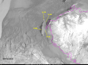
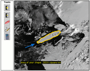
Iceberg B-15A, itself a chunk of the original Vermont-sized B-15, has finally broken into several pieces off Cape Adair.
|
It finally breaks!—Iceberg B-15A, itself a chunk of the original Vermont-sized B-15, has finally broken into several pieces off Cape Adair. According to the European Space Agency, “it broke up into 9 pieces along fault lines on October 27.”
In March of 2000, Antarctica’s Ross Ice Shelf began to calve large tabular icebergs, the first time since satellite imagery became available. SSEC’s Antarctic Meteorological Research Center has monitored their movement ever since. The very first and largest was named B-15 for its original position and chronology. Glaciologists, especially Douglas MacAyeal of the University of Chicago’s Department of Geophysics, had never been able to follow the movement of such large pieces of ice, and were excited to use the images that AMRC provided. MacAyeal also collaborated with UW’s Automatic Weather Station project that places stations throughout the continent and provides the data freely to researchers, thanks to National Science Foundation support.
When B-15 broke into 2 pieces, the AWS and AMRC groups and MacAyeal placed stations on the largest piece. Three separate stations were put on B-15A to triangulate for wind speed and direction. Since 2001, Jonathan Thom of the AWS group has placed weather stations with GPS on 3 more icebergs. This way, the researchers have been able to pinpoint the movements of the bergs. Meteorologist Shelley Knuth (AMRC) reports that 2 stations remain on B-15A, the largest of the remaining 9 pieces.
The iceberg breakup comes close to the anniversary of the signing of the Antarctica treaty. The New York Times reports that “on Dec. 1, 1959, representatives of 12 countries, including the United States, signed a treaty in Washington setting aside Antarctica as a scientific preserve, free from military activity.”
The Iceberg FAQ was written when public interest in the large icebergs was at its height. The Digital Library for Earth System Education recently incorporated it into its database of educational Web sites.
 |
|
Russ Dengel (SSEC) maintains a Web site for PDA Animated Weather (PAW). The PAW is continuously underdevelopment as Dengel accomodates request from a diverse community of PDA users.
|
Praise for PAW—Russ Dengel’s (SSEC)PDA Animated Weather (PAW), a PDA-friendly weather Web service, continues to receive glowing reviews as he updates and expands its capabilities to meet the needs of his users. The site currently provides users with composite radar and satellite weather images and forecasts. Users can chose from a multitude of geographic regions and data options including animation, zoom and roam functions.
Dengel accommodates requests from a diverse community. Recently, he tailored his services for the fire department in Puerto Rico by setting up a radar loop centered on San Juan and adding a large sector for satellite data about clouds over the area. Dengel will continue to work with fire fighters in Puerto Rico to add helpful products to the PAW service. He also helped the fire department in Boise, ID by adding sophisticated 3-D data fields and volumetric radar products.
 |
|
Dengel offers users a wide variety of weather products covering regions across the USA. Users can choose an area and set what type of data they would like to receive. PAW also lets users animate the imagery as well as zoom and roam.
|
Praise for PAW also flooded a message board on myTreo.net,a site for Treo Smart Phone users. After a user posted the link to the PAW site, others responded with compliments for the service. Many sent suggestions to Dengel, which he handled efficiently. Joe Johnson, a Treo user in California, recently sent Dengel a thank you: “I just want to say THANK YOU! You are providing a great service to the Treo community.”
The Milwaukee Area Skywarn Association also appreciates PAW products and recently added a link to the PAW site on the Skywarn Web site’s front page. The association’s executive director, Skip Voros, told Dengel that he’s “off to a great start.”
Robert Rabin disseminated word of PAW throughout the National Severe Storms Laboratory (NSSL) and passed along some of the positive feedback to Dengel. “The more I use this more it becomes evident that Russ really thought through the issues,” NSSL’s Ken Howard wrote. “What a great effort.”
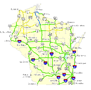 image courtesy of WI DOT |
|
Working with the Wisconsin DOT, PAW now provides information about winter road conditions.
|
Working with theWisconsin Department of Transportation, Dengel now provides a PAW version of the DOT’s winter road condition information. He plans to use the information to create an item that users can superimpose on top of current satellite and radar images.
A testament to the value of the service, new users keep picking up PAW products and spreading word of the site’s usefulness. In response to feedback and suggestions from these users, Dengel constantly adds new products and features.
Meetings and Field Experiments
AGU annual meeting —The American Geophysical Union annual meeting is the largest gathering of geophysicists and physicists in the world. The group meets this year in San Francisco from December 5–9. Researchers in SSEC’s Cooperative Institute for Meteorological Satellite Studies (CIMSS) and their NOAA counterparts stationed at SSEC have a strong presence.
Most SSEC and CIMSS presentations are being given in the Atmospheric Sciences section. Andy Heidinger (in the NOAA/NESDIS Advanced Satellite Products Branch at SSEC) was invited to give “Cloud Products: From POES to NPOESS,” written with Bryan Baum (NASA’s Langley Research Center (LARC) stationed at SSEC) and Fuzhong Weng (NOAA Science Center). This talk is an overview of the new NPOESS capabilities for cloud remote sensing and reviews planned cloud products. Heidinger will explain expected deficiencies in cloud products derived from each sensor alone and will discuss benefits of combining data from multiple NPOESS sensors.
 |
|
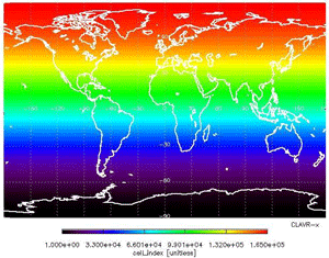
Above is a map projection created with PATMOS-x data. PATMOS-x includes data from all 5 channel AVHRR’s and includes a full suite of cloud products.
|
Heidenger is also presenting the poster, “Towards a new high cloud climatology from PATMOS-x,” produced withMichael Pavolonis(NOAA/NESDIS/ ASPB at SSEC), and Aleksandar Jelenak (NOAA/NESDIS Office of Research and Applications). ThePathfinder Atmospheres Extended (PATMOS-x) projectis a new cloud climatology using data from 1982 to 2005. PATMOS-x includes data from all 5 channel AVHRR’s and includes a full suite of cloud products.
Steve Ackerman (CIMSS director), Richard Frey, (CIMSS), EdwinEloranta (UW–Madison’s Department of Atmospheric Sciences), andRobert Holz (recent Ph.D in AOS) are presenting the paper, “ Cloud Detection: The Impact of Optical Depth, Spectral Thresholds, FOV, and Averaging,” that explores how new capabilities of the latest satellite instruments can make it easier to detect thin cirrus clouds, often missed in passive remote sensing. In her release about the paper, University Communications’ Paroma Basu notes that “scientists often struggle to define the point at which they cease to be clouds,” and that it is hard to make readings of areas filled with different clouds and cloud conditions. Her release appeared in “Wisconsin Week Wire” (December 7). United Press International and Scripps Howard News Service picked up the article. Ackerman was interviewed for LiveScience as well. Reporter Ker Thannoted that satellite data may have made traditional definitions of clouds inadequate.
 |
|
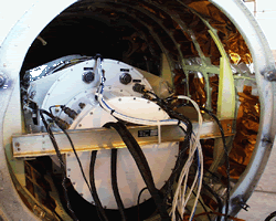
Dan Deslover presents a poster detailing results from satellite calibration and validation experiments that used NAST-I.
|
Dan Deslover (CIMSS)will present the poster, “High Spectral Resolution Infrared Cloud Measurements from the NPOESS Airborne Sounder Testbed-Interferometer(NAST-I) During Several Satellite Calibration/Validation Experiments,” produced with Holz. It focuses on flights taken on 6 September 2004 and 17 October 2004. Both campaigns were conducted over ground-based validation sites which included a suite of atmospheric sensors for comparison and calibration purposes.
In the Atmospheric Sciences poster session, Holz and Ackerman are presenting “Arctic Winter High Spectral Resolution Cloud Height Retrievals.” They present a new technique that accounts for the Arctic’s challenging winter environment that makes it difficult to accurately measure cloud-top heights.
 |
|
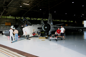
Kenneth Vinson presents a poster featuring results from AVE-Houston 2004 and 2005. The Scanning HIS took part in these field programs aboard a WB-57 (pictured above).
|
Kenneth Vinson(CIMSS) will presents the poster, “Aircraft Level Air Temperature Derived From the High Accuracy Radiometric Observations of the Scanning HIS Interferometer During the AURA Validation Experiment (AVE-Houston 2004 and 2005),” produced with Hank Revercomb,Steven Dutcher,Robert Knuteson,David Turner, and David Tobin (all SSEC). The S-HIS upwelling and down-welling radiance observations are being used in the creation of an aircraft level air temperature product. Results are presented that represent the current state of these measurements and comparisons with other in-situ temperature measurements on board the AVE flights.
In the Biogeosciences section, Robert Knuteson is presenting “Comparison of Land Surface Temperature from AIRS and MODIS,” written with Jacob Cychosz, Szu-Chia Lee, Hank Revercomb, David Tobin and Kenneth Vinson (all SSEC). Monthly mean land surface estimates of temperature from the Atmospheric InfraRed Sounder on NASA’s Aqua satellite are compared with corresponding estimates from Aqua’s MODerate-resolution Imaging Spectroradiometer.
 |
|
Tommy Jasmin, Tom Whittacker and Steve Ackerman (all of CIMSS) are working on “Satellite Observations in Science Education,” a project funded by NASA with a goal of developing an Internet-based education environment.
|
In Education and Human Resources,Tommy Jasmin is presenting “Satellite Observations in Science Education,” produced with TomWhittaker and Steve Ackerman (all of CIMSS) and L. L. Howles (UW–Madison Department of Information Technology). The five-year project, funded by NASA, has as its goal to develop an Internet-based education environment that provides interactive learning activities that teach remote sensing principles and exploratory data analysis.
In Earth and Space Science Informatics, Tom Rink presents “HYDRA—Hyperspectral Data Research Application,” written with Tom Whittaker. HYDRA is a freely available, easy-to-install Java-based tool to visualize and analyze large local or remote datasets.
 image courtesy of Bill Smith
|
|
The GIFTS program will improve severe weather forecast as well as global weather prediction models.
|
Better weather forecasts with GIFTS —During the November 29 broadcast, NPR’sNews and Notes with Ed Gordonfeatured a piece on theGeosynchronous Imaging Fourier Transform Spectrometer (GIFTS) program. Ed Gordon discussed the instrument and its potential with Bill Smith, an SSEC scientist and professor at Hampton University. GIFTS is a satellite instrument being developed to observe processes in the atmosphere that lead to storm development. In light of this year’s long and devastating hurricane season, Smith commented that GIFTS would provide “more precise landfall predictions that could save us a lot of money.” Smith also told of the instrument’s ability to improve thunderstorm and tornado forecasting. According to Smith, GIFTS could “observe the convergence of moisture in the low levels of the atmosphere, which gives rise to a severe thunderstorm or tornado, about an hour before such a s storm can be seen … on radar.” The instrument will also improve global weather prediction models. If all goes as planned, GIFTS could launch aboard a Russian satellite in 2009.
PSL connections—The Fall 2005 Observer, newsletter of UW-Madison’sPhysical Sciences Laboratory (PSL), reminded us of SSEC’s links to PSL. An article about PSL’s new firn drill notes that it is based on a design by SSEC engineer Jim Green. PSL has improved speed and smoothness of their new drill. Firn is dense, deep snow that can be difficult to drill through.
An article on IceCube, the neutrino telescope being constructed at the South Pole, notes that Claire Pettersen, IceCube Test Engineer, worked with SSEC’s Don Thielman when he was employed at PSL. Thielman is an SSEC systems engineer. Pettersen worked with him as a student helper.
 |
|
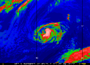
CNN used one of the Tropical Cyclones group’s images of Hurricane Epsilon.
|
One more time—As this year’s non-stop hurricane season began to wind down, Hurricane Epsilon rolled through the North Atlantic. On November 29, CNNfeatured an image from the CIMSS Tropical Cyclones group on their front page to accompany an article about Hurricane Epsilon and the “Worst Hurricane Season on Record.”
Looking back—On November 22, PBS aired Nova ’s special presentation looking at Hurricane Katrina from a scientific perspective. The companion Web site features hurricane imagery from SSEC and acknowledges CIMSS Tropical Cyclones group members Chris Velden (CIMSS) and Tim Olander (CIMSS).
Hurricane Images—On Wisconsin magazine features a stunning satellite image of Hurricane Katrina almost in the middle of its Winter 2005 edition. The UW alumni publication noted the research of the Tropical Cyclones group led by Chris Velden (MS ’82). The group develops techniques that help the National Hurricane Center make “spot-on” forecasts.
The Boscobel Dial, newspaper for Boscobel, Wisconsin, uses the same image on the first page of its second section on December 8, 2005 as its weather photo. The caption notes that the image was produced on SSEC’s Man computer Interactive Data Access System.
 |
|
Starting in December, the GOES Clear Sky Brightness product went into operational use. CIMSS researchers developed this product.
|
Product approved for operational use—TheSatellite Products and Services Review Board recently approved a Clear Sky Brightness Temperature productfor operational use starting this December. CIMSS researchers developed this product at the request of the National Centers for Environmental Prediction’s Environmental Modeling Center and the European Centre for Medium-Range Weather Forecasts. The product uses satellite data from GOES-East and –West imagers and provides information over five spectral bands. NCEP and ECMWF plan to assimilate the product into global weather prediction models to better analyze the initial state of the atmosphere when forecasting.
 |
|
Robert Aune (NOAA at SSEC) used modern forecasting technology to recreate the storm that sank the Edmund Fitzgerald. His simulation helps researchers see the “meterology behind the storm.”
|
Edmund Fitzgerald simulation makes the news—Thirty years after theEdmund Fitzgerald disappeared into Lake Superior along with her 29 crewmembers and several tons of ore, Robert Aune (NOAA at SSEC )recreated the storm that swamped the great ship that November evening in 1975. UW–Madison’s University Communications posted the press release on its Web site on November 10 and distributed it via their Wisconsin Week news wire on November 16. Science Daily, an online science news service, posted this release on November 16. WIBA and WISC-TV both interviewed Aune about his CRAS simulation of the storm that sank the Edmund Fitzgerald. WISC-TV aired the piece during its evening newscasts on November 10. The Wisconsin State Journal’s Ron Seely wrote an article about the simulation that ran on November 13. Aune also spoke about the simulation at UW-Madison’s first Wednesday Night at the Lab on November 16 where other members of the SSEC community also gave presentations.
New products for forecasters—On November 1, CIMSS began providing National Weather Service (NWS) forecast offices routinely with full resolution Derived Product Image products such as total precipitable water, lifted index (stability), and surface skin temperature. Called the Geostationary Operational Environmental Satellite (GOES) Merged Sounding Product System (MSPS), this is the first time that 10-km full resolution hourly products are being provided routinely for the standard operational display system for all NWS offices. The previous operational (DPI) products were generated at approximately 50 km resolution for the NWS Advanced Weather Interactive Processing System (AWIPS).
To educate the forecasters who will use these products, CIMSS researchers are preparing training material for the Virtual Institute for Satellite Integration Training (VISIT) program, which regularly provides distance learning to NWS offices.
Presentations and Publications
 |
|
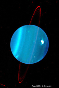
Icarus, an astronomy journal, featured images of Uranus observed by Lawerence Sromovsky and Patrick Fry with the Keck II telescope.
|
Cover of Icarus—The cover of the astronomy journal Icarus (15 December 2005) features images of Uranus observed with the Keck II telescope in Hawaii, by Lawrence Sromovsky and Patrick Fry. That issue carries their article, “Dynamics of cloud features on Uranus.” Sromovsky and Fry used the Keck II to discover numerous cloud features, the better to track winds and study the planet’s dynamics.
Presentation in Salt Lake City—At the annual combined meeting of the American Society of Agronomy, Crop Science Society of America, and Soil Science Society of America, in Salt Lake City (6-10 November) Christine Molling presented “The Impact of Log-Normally-Distributed Hydraulic Conductivity on Modeled Runoff.”
Undergraduate research—UW-Madison produced a video of the 6th annual Undergraduate Symposium last year. As part of the undergraduate research process, Steve Ackerman (CIMSS) mentored Jessica Staude(SSEC). With Ackerman’s assistance, Staude completed an atmospheric science project that she then presented at the symposium. Both Ackerman and Staude appeared in the video. Ackerman explained that undergraduate research allows students to experience what it’s like to be “a full-fledged member of a research team.”
High schoolers conduct research at CIMSS—written with help from Robert Aune As a part of a UW-Madison program, two Madison area high school students, Bryce Lampe and Adeyinka Lesi, recently completed an eight-week summer internship at CIMSS. Under the direction of Robert Aune (NOAA at SSEC), the students conducted a research project called “Modeling Satellite Tracers with a Simple Barotropic Model.” Lampe and Lesi used a simple 2-dimensional barotropic model to track 6.7 micron and 13.3 micron brightness temperatures from the GOES-12 imager at different pressure levels in the atmosphere. They were able to accurately track brightness temperatures for three-hour periods, as long as clouds were not present. Lampe and Lesi concluded their experience by presenting their results at a Madison Area School District event. The students were part of a program that placed eighteen high schoolers from the Madison area with advisors from various departments at the University of Wisconsin-Madison to experience first hand the process of conducting basic applied research.
Rosalyn Pertzborn, director of SSEC’s Office of Space Science Education, spoke to a delegation of educators, diplomats and other officials in New Delhi for launch of a new initiative between India and U.S. universities. Talks at the Indo-US Inter-University Collaborative Initiative in Higher Education and Research are taking place at the Presidential Palace, New Delhi, December 7 and 8. Pertzborn and Sanjay Limaye, SSEC planetary scientist, are representing the University of Wisconsin-Madison. Pertzborn’s presentation was one of many given by educators including deans of engineering at Harvard and University of California-San Diego, vice provosts at University of Washington, University of Massachusetts-Amherst, Georgia Institute of Technology, and many other higher education officials in the U.S. and India. Their talks followed a keynote address by Bill Gates that inaugurated the start of an “unprecedented research and education collaboration between the Indian government, several Indian universities, three international corporations and 15 U.S. universities, including the University of Wisconsin-Madison,” according to University Communications.
Inundated with praise—The stream of praise for CIMSS’s Tropical Cyclones group continues as this year’s remarkable hurricane season settles down. John Bryant from San Francisco sent the following message complimenting the group’s work on the Morphed Integrated Microwave Imagery at CIMSS (MIMIC) project, which uses satellite data to produce animations. “Great job on the MIMIC project, gentlemen,” Bryant wrote in an e-mail. “What a great resource for weather researchers. Thanks!”
Suomi student—Tom Vonder Haar, who received Master’s and Ph.D. degrees in meteorology under SSEC founding director, Professor Verner Suomi, was noted in On Wisconsin, Winter 2005. Vonder Haar was recently inducted into the National Academy of Engineering. He directs the Cooperative Institute for Research in the Atmosphere in Fort Collins, CO, a sister organization to SSEC’s Cooperative Institute for Meteorological Satellite Studies.