Monthly News Summary – November 2005
Thirty years later – Recreating the storm that sank the Edmund Fitzgerald
by Jennifer O’Leary
|
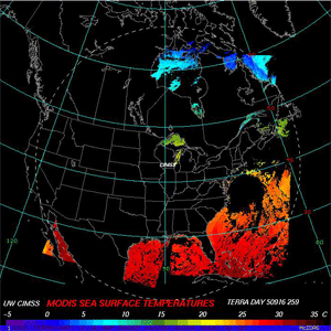
image courtesy of Robert Aune |
|
Surface wind speed (knots) and direction from a CRAS model simulation of the Edmund Fitzgerald Storm valid 12:00 PM CDT, November 10, 1975, approximately seven hours before the last communication with the ship. Northwesterly gale force winds (34 to 40 knots, in red) are indicated in the eastern Lake Superior region where the ship was lost.
|
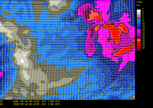
On Nov. 10, 1975, Lake Superior swallowed the Edmund Fitzgerald, along with her 29 crewmembers and cargo of almost 26,000 tons of ore. The tale of the wreck evolved into a Midwestern legend. Thirty years later, researchers at the University of Wisconsin-Madison have recreated the storm using the latest forecast technology.
November storms tend to roll across the Great Lakes, gathering strength and fury. The one that sank the Fitzgerald was no exception. Simulations of weather events like this allow scientists to identify and study characteristics of severe storms. Looking back also helps forecasters and weather modelers improve severe weather prediction techniques.
Robert Aune, a scientist with the National Oceanic and Atmospheric Administration (NOAA) stationed at the University of Wisconsin-Madison Space Science and Engineering Center (SSEC), recently created a simulation of the storm that swept across Lake Superior on that November evening.
Satellite technology was brand new in 1975, so Aune obtained conventional observations through an ongoing project at the National Center for Environmental Prediction and the National Center for Atmospheric Researchthat uses modern techniques and technology to reanalyze weather data from 1949 through the present.
Aune plugged reanalyzed data from November 8-11, 1975 into a model in operation at Madison’s Cooperative Institute of Meteorological Satellite Studies (CIMSS). The CIMSS Regional Assimilation System uses atmospheric observations from several different instruments, including those aboard satellites, to produce weather forecasts.
Aune says these models normally require satellite data, so the biggest challenge was in building this model from other data sources. The effort has broader potential, he says: “Running retrospective cases like this — especially on extreme events — is a good exercise to see if we can reproduce features of a particular storm that happened years ago.”
Besides validating the CRAS research model, Aune’s case study will be used to teach fundamental winter storm dynamics in Professor Steve Ackerman’s basic meteorology course in Madison.
WIBA and WISC-TV both interviewed Bob Aune about his CRAS simulation of the storm that sank the Edmund Fitzgerald. WISC-TV aired the piece during its evening newscasts.
 |
|
A new technique identifies volcanic ash using GOES 12 imagery and automated four-channel technology.
|
Volcanic ash identification—
Researchers at CIMSS developed a technique to identify volcanic ash using GOES 12 imagery and new automated four-channel technology. The Four Channel Volcanic Ash Mask recently identified an eruption of the Santa Ana volcano in El Salvador. The imagery of the eruption also demonstrated that this product can distinguish volcanic clouds from neighboring thunderstorms, which look similar in the visible and infrared bands.
Weather on your PDA—Russ Dengel (SSEC) recently added a Web Cam view of Lake Mendota to his host of products for PDAs. The Web Cam takes images from a window in the Soil Sciences building on the UW-Madison campus. Dengel maintains PDA Animated Weather (PAW).
Investigating suspicious results—Andy Heidinger (NOAA at SSEC) recently ran an analysis to help NASA identify the source of suspicious data. The International Satellite Cloud Climatology Project switched from Advanced Very High Resolution Radiometer on the NOAA-14 to the instrument on NOAA-16 and found an increase in clouds. Heidinger’s analysis showed that the discrepancy was not due to calibration differences between the two satellites.
Meetings and Field Experiments
|
|
|
The Mediterranean Agency for Remote Sensing and Environmental Control hosted the Direct Broadcast meeting.
|
Direct Broadcast Meeting, Benevento, Italy 3-7 October—About 200 members of the Direct Broadcast community gathered from around the world in Benevento, Italy in early October. The Mediterranean Agency for Remote Sensing and Environmental Control (MARSec) hosted the meeting that focused on three main areas: direct readout application algorithms, direct readout systems, and gap-filling missions. Cosponsors were NASA, the NPOESS Integrated Program Office,NOAA, MARSec, the University of Wisconsin–Madison, and the Province of Benevento. The meeting was covered in the Benevento newspaper and on local television.
The group, made up of users and providers of directly broadcast polar-orbiting satellite data, both current and future, meets yearly to share concerns. According to co-organizer Patrick Coronado, “in the last two years we have made great strides in obtaining, developing and utilizing science algorithms for real-time and temporal applications.” He counted 101 verifiable direct broadcast sites around the world, with varying capabilities and purposes. At the 2005 meeting, the group “explored the latest application algorithms and systems and their impact on science, commerce and decision-making infrastructures.” He noted that providing useful and timely data remained a challenge. This meeting also looked ahead to challenges to be faced during and after the planned change to the National Polar-orbiting Operational Environmental Satellite System, a converged system combining capabilities of civilian and military weather satellites.
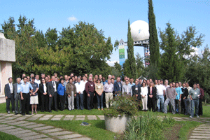 photo courtesy of Terri Gregory photo courtesy of Terri Gregory |
|
The group, made up of users and providers of directly broadcast polar-orbiting satellite data, both current and future, meets yearly to share concerns.
|
High officials of the province and University of Sannio welcomed the meeting participants. Then Jim Dodge, NASA’s first direct broadcast program manager, stated the initial program goal: “Sharing of time-critical and environmentally useful data for regional use and interpretation.” Dodge said that the program had achieved “remarkable progress in understanding satellite sensor characteristics, satellite scanning and motions, ground system designs and operations.” He gave many examples from sites around the world: the World Data Center, Hokkaido University Fisheries Science, online data from Thailand and Singapore, Korea’s browse catalog UW-Madison’s real-time products, Ocean Univ. S. Florida, Brazil’s INPE, and many hurricane images.
Attendees of the Benevento meeting receive and use data from NASA’s Earth Observing System research satellites Aqua and Terra (mostly MODIS data), NOAA satellites, Landsat, SPOT, ERS and other satellites. They presented a great variety of beneficial and creative uses of that data, including those developed at The University of New Mexico specific to regional needs like rangeland and desert assessment. The U.S. Geological Survey showed its AmericaView Project at EROS Data Center.
Among the wide variety of offerings were two outreach programs: Jasmine Nahorniak (Oregon State) presented one in development while Federica Rossi (MARSec) presented her flourishing education program, embraced by local schools at every level.
Commercial equipment providers also attended and presented features of antennas and other tools that make direct broadcast possible. One such presenter was Rich Isaacman who gave the second keynote address and noted that direct readout has changed dramatically since its beginning. He noted that an active user community is important. He hoped for a three-way partnership of users, government, and industry.
Government supports the DB community in a variety of ways, not only by supplying the data and helping other institutions to do that. Angelita Kelly (NASA Goddard Space Flight Center (GSFC)) reviewed NASA’s earth science satellite missions, pronouncing them healthy.
|
image courtesy of Kathy Strabala |
|
Kathy Strabala (CIMSS) demonstrated improvements and adjustments to the International MODIS/AIRS Processing Package (IMAPP).
|
Software and data products to enhance the data and make it easier to use were presented in abundance. Steve Dutcher (CIMSS) presented OPeNDAP, software for serving up data to users, and Hydra, client software for visualizing instrument data. Roberto Esposito (University of Sannio) presented his own algorithm to remove striping from MODIS data. Kathy Strabala (CIMSS) showed how the International MODIS/AIRS Processing Package (IMAPP), developed for the direct broadcast community, is being expanded and adjusted to be used with more data types and to work better with current ones.
Many presentations were devoted to NPOESS—its management, steps required for a successful launch and subsequent data reception, and data products to be developed and tested. Five Product Evaluation and Algorithm Test Elements ( PEATEs) are being chosen, each with a different focus. The University of Wisconsin–Madison will develop and test data products related to the atmosphere, to ensure that researchers can use data from the sensors. Robert Murphy of the Integrated Program Office, noted that the next generation imager, VIIRS, will continue the functionality of sensors like DMSP’s Optical Line Scanner , NOAA’s Advanced Very High Resolution Radiometer , and NASA’s SeaWIFS and MODerate-resolution Imaging Spectroradiometer , with many enhancements. The new polar-orbiting satellite system will cover the globe completely every day. NPOESS contractor Northrup Grumman’s John van de Wouw presented a roadmap to the eventual implementation. Meeting co-organizer John Overton was excited by the accomplishments made with Terra and Aqua from launch through product development. He assured the audience that NPOESS would be as gratifying, if as challenging.
Posters showed a wide variety of direct broadcast data uses, including a new fire information system for southern Africa, detecting fog in India, temperature analysis of Switzerland’s Lake Geneva, MARSec and CIMSS collaboration in a parallel processing computing environment, developing algorithms to monitor the environment and vegetation change in New Mexico, NPOESS direct readout terminals and other hardware developments, and many other areas of research and current use.
A common theme of providers and users alike was the need for near real-time data in the most useful form possible. Publishing on the Web was considered a good way to do this.
 photo courtesy of Terri Gregory photo courtesy of Terri Gregory |
|
Meeting participants and their guests enjoyed the legendary Italian food and hospitality.
|
Italian food and hospitality are legendary. That experienced during the week of the meeting was no exception. A local business catered delicious lunches and receptions, and participants were treated to two exciting outings. Monday evening’s was somewhat marred by rain and the lateness of the hour, but attendees and guests were still charmed by the visit to a traditional family-style restaurant and winery. After hours of driving on Benevento province’s winding mountain roads, bus passengers collectively gasped at the vision of S. Agata dei Goti’s walls carved out of local rock—buildings were lit up and clearly visible upon approach over the main bridge into the tiny mountain village. A visit to the underground winery and a traditional Italian family-style multicourse meal were highlights of the evening. After the meeting’s official end Thursday, many meeting attendees stayed for a Friday visit to famed Pompeii, south of Naples in the shadow of Mt. Vesuvius, still an active volcano.
Meeting organizers were Patrick Coronado (NASA’s Goddard Space Flight Center), John Overton (NPOESS Integrated Program Office), Liam Gumley (SSEC), Federica Rossi (MARSec) and Paolo Antonelli (CIMSS). Presentations will be made available on the Web.
MUG meets in Madison—The University of Wisconsin-Madison’s Space Science and Engineering Center hosted the annual Man computer Interactive Data Access System (McIDAS) Users’ Group Meeting on October 27-28 at Madison’s Edgewater Hotel. The annual meeting provides an opportunity for members of the McIDAS Users’ Group to exchange information and give input on the development of the system to staff at SSEC.
 |
|
At the 2005 meeting of MUG, members had a chance to exchange information and give input on the development of the system.
|
A sophisticated suite of software packages, McIDAS helps users acquire, display, analyze, interpret and manage geophysical data. Thirty-nine sites in six countries and across the United States constitute the McIDAS Users’ Group. SSEC created McIDAS and continues to maintain it. New users in 2005 include the Indian Space Research Organization’s Space Applications Centre in Ahmedabad, India; the National Weather Service Pacific Region in Honolulu, HI; and Honeywell Aerospace in Redmond, WA.
Approximately 40 MUG members attended the meeting where presenters from different sites described and discussed issues with software and data.Presentations included the status of current and plans for future geostationary and polar-orbiting satellites, and the servers to handle satellite and other data. The use of files in the World Meteorological Organization’s standard format, the GRIdded Binary (GRIB) format, received particular attention. GRIB, a much more compact data format than the native McIDAS GRID file format, will replace the latter to handle model output.
After a look at the current version of McIDAS, Tom Whittaker (CIMSS) and Gail Dengel (CIMSS) gave the audience a preview of McIDAS’s future. They demonstrated the initial efforts for the new McIDAS-V development project, which utilizes tools from both the McIDAS VisAD and Unidata IDV (Integrated Data Viewer) software systems. McIDAS-V also will include features to link to McIDAS-X, the current McIDAS version. The preview generated much interest and anticipation among the audience members. The Data Center hopes to release McIDAS-V in 2007.
 image courtesy of Liam Gumley
|
|
During hurricane season, the Tropical Cyclones group helps the public understand the science behind hurricanes. Hurricane Wilma brought the group another torrent of media requests.
|
Inundated—As this year’s eventful hurricane season continued through late October, Hurricane Wilma brought another torrent of media requests forCooperative Institute for Meteorological Satellite Studies’s Tropical Cyclones group. The group provides a valuable resource for the media as they try to keep the public aware and informed.
Many on-air interviews with members of the group gave details about the science behind hurricanes. On October 21, Tim Olander (CIMSS) appeared on Wisconsin Public Television’s Here and Now to discuss the Tropical Cyclones group’s work and Hurricane Wilma. The Here and Now Web page includes links to the CIMSS home page and the Tropical Cyclones site. On October 23, Madison’s local NBC affiliate interviewed Tony Wimmers (CIMSS) and Howard Berger (CIMSS) for the 10 p.m. news. The piece included imagery produced by CIMSS researchers. An article in the October 26 edition of the Capital Timesincluded comments from Berger on the property destruction caused by hurricanes in Florida. Wimmers and Berger also appeared with Dave Stettner (CIMSS) on Milwaukee Channel 12’s 5 p.m. newscast. A few days later, Stettner fielded a phone call from WiBA radio verify hurricane information.
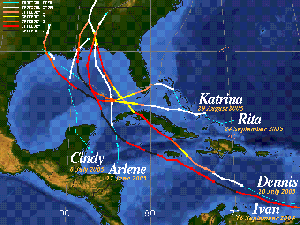 image courtesy of Tim Olander
|
|
Tim Olander created this image for the Gulf Islands National Seashore park newspaper. It shows the tracks of the hurricanes that blew through that area in 2004 and 2005.
|
In addition to interviews, media outlets also find the group’s imagery useful. After Hurricane Katrina, Olander created an image for the Gulf Islands National Seashore park newspaper. The image featured the paths of the tropical cyclones and hurricanes that devastated the area in 2004 and 2005. “As editor of the park newspaper, which is handed out to the tourists coming to the National Park, your team provided the best source that I could find to assimilate the incoming storms,” Park Ranger Beckie Mims said in an email.
One of SSEC’s Hurricane Katrina images appeared prominently in a full-page ad that ran in the New York Times for Environmental Defense and accompanied an article on the Environmental Defense Web site. TheUniversity of Northern Iowa also used an SSEC image of Hurricane Katrina with a message about hurricane relief efforts from the university’s president. NASA’s Earth Observatory Web site posted an image of Hurricane Wilma processed by Liam Gumley (SSEC) using data from SSEC’s direct broadcasting facility. As Hurricane Vince loomed off the Iberian Peninsula, Stettner provided imagery to Spain’s Revista del Aficionado a la Meteorologia. This online newsletter featured an article on Vince in its November edition and two images from the Tropical Cyclones group accompanied the article.
Many of these groups and publications found these images through theTropical Cyclones Web site, which typically receives many visitors during hurricane season. The site set its current record of three million hits in one day last year during Hurricane Ivan. This year, September 21 came close with approximately 2.5 million hits. “Words cannot describe how much your web site has helped me to know and understand what’s going on,” said New Orleans native George Izquierdo in an email after Hurricane Katrina.
SSEC in Polar Press Clips 2005 —Every year, the National Science Foundation compiles news about the polar regions from each year. Polar Press Clips 2005 included an article that refers to SSEC’s work in support of the IceCube project. Originally published on January 4, 2005 in Daily Pioneer News, the article profiles Brain Pechan, a “UWP alumnus working in Antarctica.” The story mentions SSEC’s Ice Coring and Drilling Service’s Enhanced Hot Water Drill and the center’s role in developing the requirements for the drill.
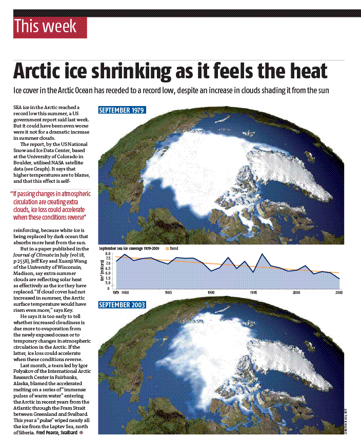
Melting Arctic ice —The ice floating in the Arctic Ocean continues to shrink, setting a record low at the end of summer 2005. An article in the October 8 edition of New Scientist investigated what causes the ice to melt. The article mentions results from a recent climate change study conducted byXuanji Wang (CIMSS) and Jeff Key (NOAA at SSEC). The study looked at the relationship of cloud cover over the Arctic and the amount of ice in the Arctic sea. Wang and Key determined that the increased cloud cover during the summer months over the last decade actually moderated the effects of higher temperatures.
Measuring rainfall—Chris Velden (CIMSS) recently served on a committee commissioned by NOAA to assess the future of space-based missions to measure rainfall. The committee focused on providing pre-launch recommendations for NASA’s Global Precipitation Measurement Missionand determining possible uses for the data. The final report is due next summer.
Weather Guys— Weather Guys and professors Steve Ackerman andJonathan Martin answered sundry questions about weather and climate in their appearance on Larry Meiller’s WHA Radio call-in show Monday morning, October 31. They explained how much energy it would take to move large tabular icebergs to supply freshwater needs and take them out of the way of ships and penguins. They noted that the icebergs wind up in the iceberg graveyard, would also mess up the fresh water balance in the Pacific Ocean. They also discussed the three different types of storms called cyclones. You can learn the fascinating answers to questions like these by listening the last Monday of every month. In Madison and the surrounding area, tune your radio to 970 AM or 90.7 FM, or listen on the Web from anywhere. You can also use the station’s online archive. Ackerman directs UW-Madison’s Cooperative Institute for Meteorological Satellite Studiesand Martin chairs the Department of Atmospheric and Oceanic Sciences.
Presentations and Publications
Cloud properties paper published—The October issue of the Journal of Applied Meteorology included a paper titled “Retrieval of Cloud Microphysical Properties from MODIS and AIRS.” Jun Li (CIMSS),Allen Huang (CIMSS) and Tim Schmit (NOAA at SSEC) co-authored this paper with Ping Yang of Texas A&M University.
AIRS sounding retrieval paper published— Advances in Atmospheric Sciences published a paper on AIRS sounding retrieval in the October issue. Jun Li (CIMSS), XuebaoWu (CIMSS), and Fang Wang co-authored the paper titled “Atmospheric profile retrieval with AIRS data and validation at the ARM cart site.”
 |
|
The Science Alliance booth at the WEEA conference featured information about members of the alliance including SSEC.
|
Science Alliance booth—Margaret Mooney (SSEC) organized the UW Science Alliance booth at this year’s annualWisconsin Association for Environmental Education conferenceheld on October 28 at the Pyle Center. The booth featured information about different members of the alliance including SSEC.
Looking ahead —SSEC will host the first Wednesday Nite @ the Lab on November 16 at 7 p.m. in the Genetics/Biotech auditorium. SSEC’s librarian, Jean Philips (SSEC), will present The Bentley Snow Crystal Collection, an assortment of snow crystal images from the 19th century. The Antarctic Meteorological Research Center’s Matthew Lazzara (AMRC) will relay tales of adventures conducting research in the Antarctic. Finally, Howard Berger (CIMSS) will discuss how 21st Century satellite technology improves the ability to forecast and track hurricanes. According to the UW’s Osher Lifelong Learning Institute’s Web site, the night at the lab allows participants to “see science in action in a real UW lab when you come to campus for free, hands-on learning sessions.” Margaret Mooney (SSEC) will accompany and introduce the group.
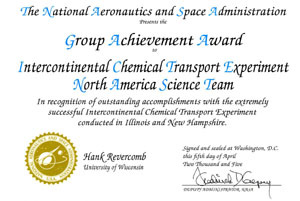
Folklore award for Wisconsin Weather Stories— The Folklore and Education Section of the American Folklore Society awarded the 2005 Dorothy Howard Folklore and Education Prize to the Wisconsin Weather Stories project for “most effectively [encouraging] folklore and folkloristic approaches in school environments.” Started in 2003, the Wisconsin Weather Stories project created a curriculum using a collection of local weather stories and meteorological data. The Cooperative Institute of Meteorological Satellite Studies within the University of Wisconsin-Madison’s Space Science and Engineering Center, Wisconsin Arts Board, and the UW Folklore Program all participated in the project and share the award. Group achievement award— Hank Revercomb (SSEC) recently received an award from NASA for his role in the North American Science Team during an experiment last year. Revercomb and the Scanning HIS team participated in the Chemical Transport Experiment conducted in Illinois and New Hampshire.
Professor Steven Ackerman, director of CIMSS, suggests that, “Often in our society, science and folklore are set up as oppositional, as in technology vs. tradition, or logic vs. irrationality. One project goal was to model a new kind of interaction between folklore and science, showing that both are based on careful observation of one’s environment.” The reviewers recognized that element in Wisconsin Weather Stories, explaining, “It compliments rather than debunks the value of folklore concepts’ interaction with science concepts.”
University communications featured SSEC’s release regarding this award as the top news story on November 1. UW-Madison’s home page displayed a link to the story. The release included links to CIMSS’s home page and the Wisconsin Weather Stories’ Web site.
SSEC staff members elected officers—Two SSEC staff members currently serve as officers in the Federation of Earth Science Information Partners (ESIP). Officers were elected during the consortium’s annual meeting in June in San Diego. Among them are Margaret Mooney(SSEC), who, as Vice Chair of Education, assists the chair of that committee, and Tommy Jasmin (CIMSS), Vice Chair of Information Technology and Interoperability, assists the chair of that committee. ESIP conducts business primarily through its committees, so that the education committee helps develop and standardize educational materials, while the committee devoted to information technology and interoperability in part tries to ensure that “data, information and services can be readily exchanged and integrated to improve Earth science data, information, products and services.” ESIP was founded in 1998 with funds from NASA to collect, interpret and develop applications for satellite-generated Earth observation information. According to its Web site, “the consortium includes more than 80 member organizations, spanning NASA and NOAA’s data centers, government research laboratories, research universities, education resource providers, technology developers, and nonprofit and commercial enterprises.” Its Web site is an amazing resource in itself, listing many, many tools and data sets of interest to the earth science community and the general public.
Thanks from the Air Force Academy —Major Kurt Brueske recently thanked Tom Whittaker (CIMSS) for allowing the United States Air Force Academy to use his WINPLOT java applet, which SSEC uses to produce the local weather update on the SSEC Homepage. According to Major Brueske, Whittaker “went out of the way to answer newbie java-related questions.” In 2004, Whittaker provided the source code for the applet to allow those at the academy to monitor local weather conditions. The link opened for public use in 2005.