Monthly News Summary – October 2005
A popular source for hurricane information
by Jennifer O’Leary
 |
|
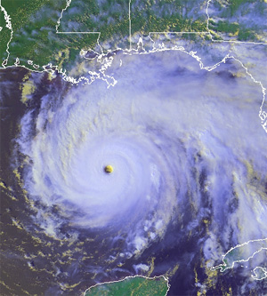
Chris Velden and his Tropical Cyclones research team use satellite data to study hurricanes and develop better prediction tools. The above image was produced using data from NOAA-16 on September 22.
|
Hot on the heels of Hurricane Katrina, this year’s hurricane season continued to rage off the coast of the southern United States with Hurricanes Ophelia and Rita. Seeking explanations and predictions, the media once again turn to the Cooperative Institute of Meteorological Satellite Studies’ Tropical Cyclones team.
“It makes us feel good that we’re playing a small role in the saving of lives, potentially,” team leader Chris Velden (CIMSS) said in a report aired on Madison’s ABC affiliate on September 22. Velden and his research team use satellite data to study hurricanes and develop better prediction tools.
As Hurricane Rita intensified on September 21, the band of researchers used their tools to provide the National Hurricane Center with invaluable information. The reconnaissance plane scheduled to fly into the storm on the night of the 20th experienced technical difficulties and turned back. During this time, a computer procedure called the Advanced Objective Dvorak Technique indicated a rapid intensification. Velden noticed this and notified the crew at the National Hurricane Center. His contribution appeared in the hurricane center’s online discussion: “Satellite images indicate that the cloud pattern is typical of an intense hurricane … T-numbers from … the University of Wisconsin CIMSS are peaking near 7.0 on the Dvorak scale.” Developed by the CIMSS team, the technique uses digital infrared information to create a profile for a storm including its strength and potential path.
 |
|
“It helps forecasters reduce the time that they spend trying to use [satellite data] to decide what’s happening,” team member Tony Wimmers said in the ABC report.
|
In addition to supplying information on the fly, the Tropical Cyclones group provides many real-time products to the National Hurricane Center and other government organizations. The group creates and improves technology that helps meteorologists use satellite data to better understand the characteristics of tropical cyclones. Their work results in more accurate forecasts and, consequently, more effective warnings for the public. “It helps forecasters reduce the time that they spend trying to use [satellite data] to decide what’s happening,” team member Tony Wimmers said in the ABC report.
The media rely on the CIMSS team to help the public figure out the science behind the hurricane reports. On the 22nd, ABC reporter Carl Agnelly (with local WKOW-TV) spoke with Velden and Wimmers. The report focused on the different products and techniques Velden and his team use to aid forecasters. The footage included shots of the group’s imagery as well as a look at the instrumentation on the roof of SSEC’s home in the Atmospheric, Oceanic & Space Sciences Building. Velden also appeared on WISC-TV’s Live at Five on September 20 and gave an interview to the Los Angeles Fox News affiliate. He also spoke with WIBA Radio’s Josh Wescott.
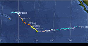
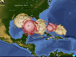 image courtesy of Tim Olander image courtesy of Tim Olander |
|
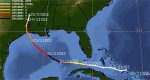
Tim Olander produced this image showing Hurricane Rita’s track with Hurricane Katrina’s. The image used the data available on September 23.
|
Tim Olander, a researcher with the Tropical Cyclones team, also provided the media witha tool to communicate with the public. At the request of The Star Ledger, Olander produced an image showing Hurricane Rita’s track along side Hurricane Katrina’s. According to the graphics editor, the image appeared on the front page of their September 23 evening edition.
While appearing in various media outlets, the Tropical Cyclones team also maintains a large Web presence. Imagery and detailed forecast data make their Web site a popular stop for those seeking information about hurricanes. The site received 2.5 million hits on September 21, nearing their record of three million set last year during Hurricane Ivan. Yahoo currently lists the group’s site in its directory for current information on hurricanes, typhoons and tropical cyclones.
Unsolicited praise for their tropical cyclones site reflects its popularity and utility. “Your Web site is the best weather site I have ever seen! Keep up the good work and thank you for being there,” Janet West Brooks of Suncoast Property Consultants in St. Pete Beach, FL said in e-mail. Laura Wheeler with the American Red Cross also offered up praise for the site. “I just wanted to say thank you for keeping the Web site up to date with such wonderful pictures and information,” she said. “I have printed out a couple pictures to use on our bulletin board for visuals and everyone loves them.”
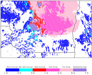
Another look at the tornado outbreak— written with help from Kris Bedka Using data from the tornado outbreak in Southwestern Wisconsin on August 18, Kris Bedka (CIMSS) demonstrated the stand-alone value of satellite-derived products to forecasters for thunderstorm growth prediction. These particular products constitute an element in an aviation safety system for thunderstorm avoidance under development by a team within the Federal Aviation Administration (FAA) and are provided by CIMSS researchers as a part of the Advanced Satellite Aviation Weather Products (ASAP) program. While only a piece of the puzzle in the FAA’s system, Bedka applied the products to the data from August 18 and found that an individual forecaster relying solely on satellite information could have identified the precursors to predict the severe thunderstorms and tornados that eventually occurred. According to Bedka, a forecaster can pick out important details from these products that a computer may ignore.
 |
|
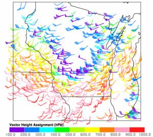
Before the storms on August 18, the satellite wind product indicated certain factors that trigger thunderstorm development.
|
For example, a product that looks at wind datashowed a subtle change in direction of the wind with higher altitudes to the east of the storms and a flow of air from western Wisconsin set to converge with it. A forecaster on August 18 would have identified the collision of these winds as a trigger for continued thunderstorm development. The satellite wind product allows a forecaster to identify signs of impending storm characteristics. These include storm-induced wind speeds at the surface and the possibility for hail and tornadoes associated with rotating storms.
 |
|
The convective cloud mask helps forecasters identify clouds with the potential to become thunderstorms.
|
Another product helps monitor cloud characteristics. Using statistical properties of cloud features to identify six different classes of clouds, theconvective cloud maskspeeds up the forecasting process by pointing out the clouds with the potential to evolve into thunderstorms. Satellite-derived imagery shows the differences among the clouds, allowing the mid-level “towering” cumulus clouds to stand out from the others – something that a weather prediction model will not indicate. Forecasters looking at the data from this product on August 18 would have noticed these threatening clouds in the pre-storm environment.
 |
|
The cloud-top cooling rate corresponds to the cloud’s growth. A faster cooling rate indicates faster growth and a potential thunderstorm.
|
A forecaster can get even more specific by monitoring the temperatures at the top of the clouds with the15 cloud-top cooling rate product. Faster cooling rates signal faster growth and stronger storm updrafts. Once rapid growth begins, it often doesn’t stop until the cloud becomes a huge thunderstorm. “It’s almost like taking a boulder and pushing it down a hill,” Bedka said. Using this satellite product, forecasters on August 18 would have had only to watch the clouds with rapid cooling rates.
Bedka notes that demonstrating the forecaster’s ability to obtain so much prediction information from a satellite has broad implications particularly in areas of the world do not have the other pieces included in the FAA’s system such as high-resolution computer model output or radar data. Although these regions lack weather radar coverage, satellites can see these areas well and can provide beneficial information. SSEC’s interactive case study of the August 18 tornado event now includes Bedka’s analysis.
Educating educators about hurricanes—The Teacher’s Domain projectplans to use imagery from CIMSS’s Tropical Cyclones team in their hurricanes section. They will use the images of Hurricane Ivan that previously appeared in NOVA ScienceNow: Hurricanes. Teacher’s Domain targets teachers and students in grades K-12. The project provides an interactive Web-based resource for a variety of topics.
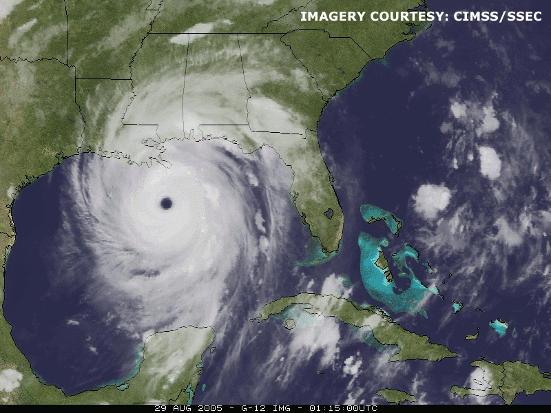 image courtesy of Rick Kohrs image courtesy of Rick Kohrs |
|
The National Climate Data Center used this animation of Hurricane Katrina on a page devoted to hurricane climatology. Click for animation.
|
Featured animation—The National Climate Data Center used an animation of Hurricane Katrina on their page devoted to hurricane climatology. Rick Kohrs (SSEC) produced the animation. The page also links to CIMSS’s Tropical Cyclones team’s Web page for Hurricane Katrina.
Featured on the UW-Madison home page—The University of Wisconsin-Madison’s home pagecurrently includes an SSEC image of Hurricane Katrina created by Dave Santek (CIMSS) under “Featured Sites.” The image links to a page with information about ways to offer help to those areas devastated by the storm. A section for media outlets seeking information directs users to the September edition of In the News for “expertise on hurricane imagery and forecasting.”
 |
|
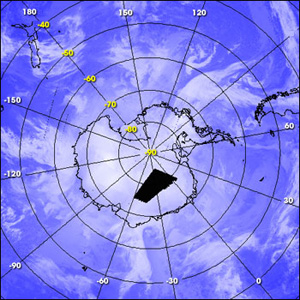
Some of SSEC’s work in polar regions received mention in an article featured in NASA’s Earth Observatory. Several images from the AWS/AMRC gallery accompany the article, including a composite image of Antarctica cloud conditions on September 6. |
Providing “instant” data—SSEC’s work in polar regions received mention in aSeptember 6 articlefeatured in NASA’sEarth Observatory. The article discusses the importance of MODIS data to polar research projects. Jeff Key (NOAA at SSEC) and Matthew Lazzara (CIMSS) helped install a MODIS direct broadcast system at McMurdo Station in Antarctica. Reporter Holli Riebeek notes that this direct broadcast capability will improve weather forecasts and help researchers monitor weather conditions while working in the field. She also includes information about Lazzara’s plans to use the data to research fog in Antarctica and about Key’s polar winds work. Several images from the AWS/AMRC gallery accompany the article, including one taken by Shelly Knuth (SSEC’s AMRC) and a composite image of Antarctic cloud conditions from September 6.
 |
|
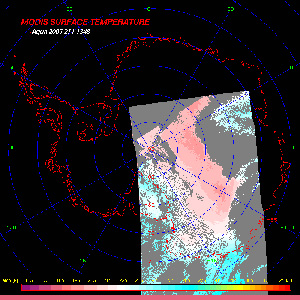
The MODIS DB suite at McMurdo now generates several more products, including ice surface temperature.
|
Expanding the McMurdo product suite—The MODIS Direct Broadcast suite at McMurdo now includes several more products. In addition to the polar wind product, the system also generates: cloud amount, cloud top pressure, cloud particle phase, clear-sky, low-level atmospheric temperature inversion strength and depth, ice surface temperature and ice surface albedo. All of the processing occurs at McMurdo. With this system, the goal is to provide forecasters with real-time products and to decrease the time necessary to produce wind data. Faster generation of these data sets will facilitate their incorporation into numerical weather prediction systems.
Creating a long-term Polar Wind record —Recently, CIMSS’s Richard Dworak began generating polar wind information using historical Global Area Coverage data from the Advanced Very High Resolution Radiometer (AVHRR). Dworak plans to produce a data set that includes wind speed, height, and direction in Polar Regions from 1982-2004. Researchers will find the data set helpful in climate studies as well as for future re-analysis projects at the National Centers for Environmental Prediction (NCEP), the National Center for Atmospheric Research (NCAR), and the European Centre for Medium-Range Weather Forecasts (ECMWF).
 |
|
UW/CIMSS analyses contributed significantly to a National Hurricane Center online discussion of Hurricane Jova. This image shows the storm’s track.
|
Contributing to hurricane discussions—CIMSS received credit in an online National Hurricane Centerdiscussion on September 22. UW/CIMSS analyses contributed significantly to the discussion of the weakening of Hurricane Jova, particularly in the sections about the vertical wind shear. “I don’t think I’ve ever seen this much CIMSS coverage in one [tropical cyclone] report!” Dave Stettner (CIMSS) said.
Tropical cyclone experts—Tim Olander and Jim Kossin of CIMSS’s Tropical Cyclones group added their insight to a September 9 Science Magazine article on Hurricane Katrina. Olander commented on the storm’s rapid intensification and discussed the rarity of such an event. Kossin theorized about the causes. He indicated that the unusually warm waters in the Gulf of Mexico and the absence of strong, high-altitude winds probably contributed. Go to Hurricane Katrina and Its Aftermath to access content free to the public. This includes the article that quotes Olander and Kossin,“Scientists’ Fears Come True as Hurricane Floods New Orleans.”
A positive story of hurricane forecasting—One of UW-Madison’s student newspapers, The Daily Cardinal, ran an article about the highly accurate forecasts of Hurricane Katrina in their September 28 edition. Reporter Mike Richards spoke with Chris Velden (CIMSS) and Tim Olander (CIMSS) to uncover the positive story amid disaster. Velden discussed the “live toll” that will reach into the millions as a direct result of excellent forecasting efforts that predicted the area where the storm would make landfall with an unprecedented 15-mile margin two days before the storm hit. Forecasters also correctly predicted the storm’s intensity as it made landfall. Olander stressed that it is important not to “cry wolf” when forecasting a hurricane’s intensity as it hits land and he reminded readers of the high costs attached to public severe weather warnings.
Presentations and Publications
IDEA on the cover—The Bulletin of the American Meteorological Society (BAMS) used an article about the multi-agency partnership to Infuse Satellite Data into Environmental Applications (IDEA) for the cover story of their September issue. The article focused on a study from September 2003 that demonstrated the capabilities of an online tool to improve air quality forecasts of fine particulate matter. Because of the Environmental Protection Agency’s positive feedback, CIMSS took on the project in 2004 and the prototype expanded.
Cultural angle —The fall edition of On Wisconsin included a mention of a science program developed to connect Native American storytelling to science. Sanjay Limaye (SSEC) and Patty Loew of the UW’s Life Sciences Communications Department put together this outreach effort with northern Wisconsin in mind and plan to travel to several schools over the academic year. The goal is to encourage Native American children to study science.
 |
|
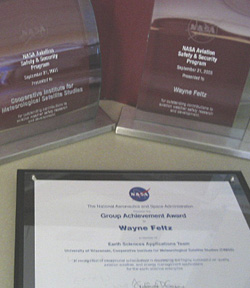
The NASA Aviation Safety and Security Program presented Wayne Feltz and CIMSS with trophies for their work in ASAP and the TAMDAR validation. Several CIMSS researchers received individual certificates of appreciation.
|
National recognition—On September 21, the NASA Aviation Safety and Security Program presented Wayne Feltz (CIMSS) and CIMSS with trophies for research in the Advanced Satellite Aviation-weather Program (ASAP), and their work on Tropospheric Airborne Meteorological Data Report (TAMDAR) validation. Feltz was both the ASAP leader at CIMSS and the principal investigator for the UW-CIMSS TAMDAR validation project. The NASA Aviation Safety and Security Program funded both research endeavors. Anthony Wimmers, Michael Pavolonis, Kristopher Bedka, Sarah Bedka, Steven Ackerman, andChristopher Velden (all with CIMSS) received certificates of appreciation for their work on ASAP. CIMSS efforts for the TAMDAR validation project also earned Sarah Bedka, Kristopher Bedka, John Short, andErik Olson (all with CIMSS) certificates of appreciation.
Hard work awarded—by Alex Harrington
Alex Harrington, an undergraduate senior working for CIMSS, recently attended the Regional Space Grant Consortium (RSGC) conference September 15-17th in Chicago, IL. There, he presented a poster titled “Validating CRAS forecasted satellite imagery using GOES.” Harrington’s research demonstrates validation of forecasts derived from a numerical weather prediction model, the CIMSS Regional Assimilation System (CRAS), when compared against actual satellite imagery from Geostationary Operational Environmental Satellites (GOES). The conference included many undergraduate and graduate students from all areas of aerospace science across the Midwest. Harrington was the only student from Wisconsin, and the only student to present meteorology-oriented research at the conference. By earning first place in the poster session, Harrington was invited to give a special presentation of his research. He also received a $500 award, which will be matched by the Wisconsin Space Grant Consortium (WSGC). Harrington would like to thank WSGC and RSGC for such a noteworthy experience.
In Ackerman’s view—CIMSS’s Steven Ackerman took time from his busy schedule to speak at the Chazen Museum of Art on September 13. He compared a group of landscape paintings from 19th century Europe and Russia. Ackerman analyzed the use of color in clouds, sky, and water while he helped the audience to see these works from his perspective as an atmospheric scientist.
Building images—The fall edition of On Wisconsin featured a story detailing UW-Madison’s plans for a campus makeover based on an architect’s vision from almost 100 years ago. Several photos accompany the article including two that clearly show SSEC’s 16-floor building with its roof-top array of instruments.